
Conasprella (Conasprella) boucheti ( Richard, 1983 )
|
publication ID |
https://doi.org/ 10.5852/ejt.2023.896.2291 |
|
publication LSID |
lsid:zoobank.org:pub:F53C16AD-46F5-413B-9ACE-29713C9ED8D9 |
|
DOI |
https://doi.org/10.5281/zenodo.8414976 |
|
persistent identifier |
https://treatment.plazi.org/id/03898788-CA77-3C51-D7A2-FE1A33EDFDFC |
|
treatment provided by |
Plazi |
|
scientific name |
Conasprella (Conasprella) boucheti ( Richard, 1983 ) |
| status |
|
Conasprella (Conasprella) boucheti ( Richard, 1983) View in CoL View at ENA
Figs 2 View Fig , 34–35 View Fig View Fig
Conus (Endemoconus) boucheti Richard, 1983: 53 View in CoL .
Conus View in CoL species no. 108, 108a – Estival 1981: 110–111.
Conus boucheti View in CoL – R̂ckel et al. 1995b: no. 237, pl. 51 figs 21–24.
Endemoconus boucheti – Tucker & Tenorio 2013: 115.
Conasprella boucheti View in CoL – Monnier et al. 2018a: 196.
Material examined
176 lots (438 specimens). See Supp. file 1.
Type material
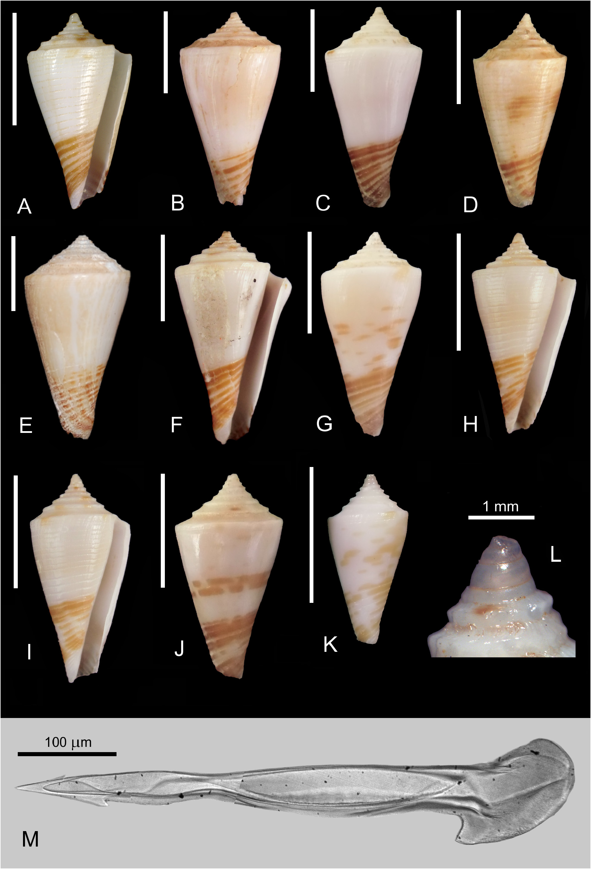
Holotype NEW CALEDONIA • 17.5 mm; SW of Île des Pins, off New Caledonia ; 22°05′ S, 167°15′ E; 400 m depth; MNHN-IM-2000-2578 ( Fig. 34A View Fig ). GoogleMaps
Figured material
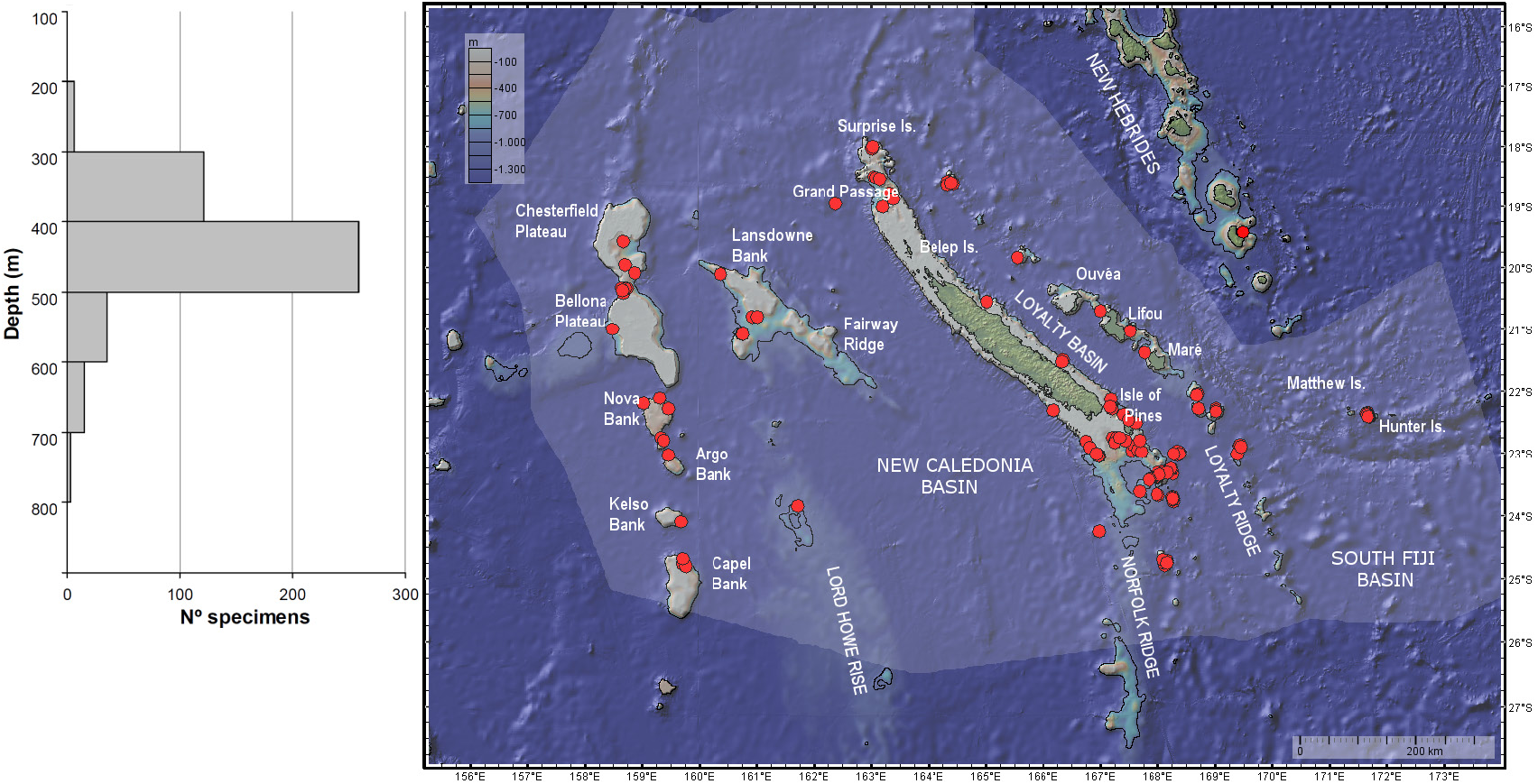
NEW CALEDONIA • 23.8 mm; off New Caledonia , stn CC246; 22º08′ S, 167º11′ E; 410‒420 m depth; 3 Oct. 1985; MUSORSTOM 4 expedition; MNHN ( Fig. 34B View Fig ) GoogleMaps • 24.5 mm; Plateau des Chesterfield , off New Caledonia, stn DW2610; 19º34′ S, 158º41′ E; 486‒494 m depth; 19 Oct. 2005; EBISCO expedition; MNHN ( Fig. 34C View Fig ) GoogleMaps • 20.8 mm; Loyalty Ridge , off New Caledonia, stn DW460; 21º02′ S, 167º31′ E; 420 m depth; 20 Feb. 1989; MUSORSTOM 6 expedition; MNHN ( Fig. 34D View Fig ) GoogleMaps • 27.3 mm; Lansdowne Fairway , off New Caledonia, stn DE16; 20º48′ S, 160º56′ E; 500 m depth; 21 Jul. 1988; CORAIL 2 expedition; MNHN ( Fig. 34E View Fig ) GoogleMaps • 24.8 mm; off S New Caledonia , stn DW222; 22º58′ S, 167º33′ E; 410‒440 m depth; 30 Sep. 1985; MUSORSTOM 4 expedition; MNHN ( Fig. 34F View Fig ) GoogleMaps • 20.2 mm; Norfolk Ridge , Banc Jumeau Est, off New Caledonia, stn DW13; 23°45′ S, 168°17′ E; 400 m depth; 12 Aug. 1999; LITHIST expedition; MNHN ( Fig. 34G View Fig ) GoogleMaps • 17.2 mm; Loyalty Ridge , off New Caledonia, stn DW459; 21º01′ S, 167º31′ E; 425 m depth; 20 Feb. 1989; MUSORSTOM 6 expedition; MNHN ( Fig. 34H View Fig ) GoogleMaps • 18.5 mm; same collection data as for preceding; MNHN ( Fig. 34I View Fig ) GoogleMaps • 18 mm; Nova Bank Nord , off New Caledonia, stn DW2534; 22º17′ S, 159º28′ E; 390‒430 m depth; 10 Oct. 2005; EBISCO expedition; MNHN ( Fig. 34J View Fig ) GoogleMaps • 12.6 mm; Loyalty Ridge , off New Caledonia, stn DW487; 21º23′ S, 167º46′ E; 500 m depth; 23 Feb. 1989; MUSORSTOM 6 expedition; MNHN ( Fig. 34K View Fig ) GoogleMaps • 19.6 mm; Norfolk Ridge , Munida, off New Caledonia, stn DW3107; 23º01′ S, 169º23′ E; 380‒440 m depth; 27 Oct. 2008; TERRASSES expedition; MNHN ( Fig. 34L View Fig ) GoogleMaps • 19 mm; Grand Passage , off N New Caledonia, stn DW3003; 18º34′ S, 163º08′ E; 450-454 m depth; 7 May 2008; CONCALIS expedition; Atheris coll. ( Fig. 34M View Fig ) GoogleMaps .
Geographical distribution and bathymetry
New Caledonia, Coral Sea and New Hebrides Arc including Vanuatu, typically at depths between 300 and 600 m. Also reported from Fiji at depths of 390‒405 m ( Moolenbeek et al. 2008).
Remarks
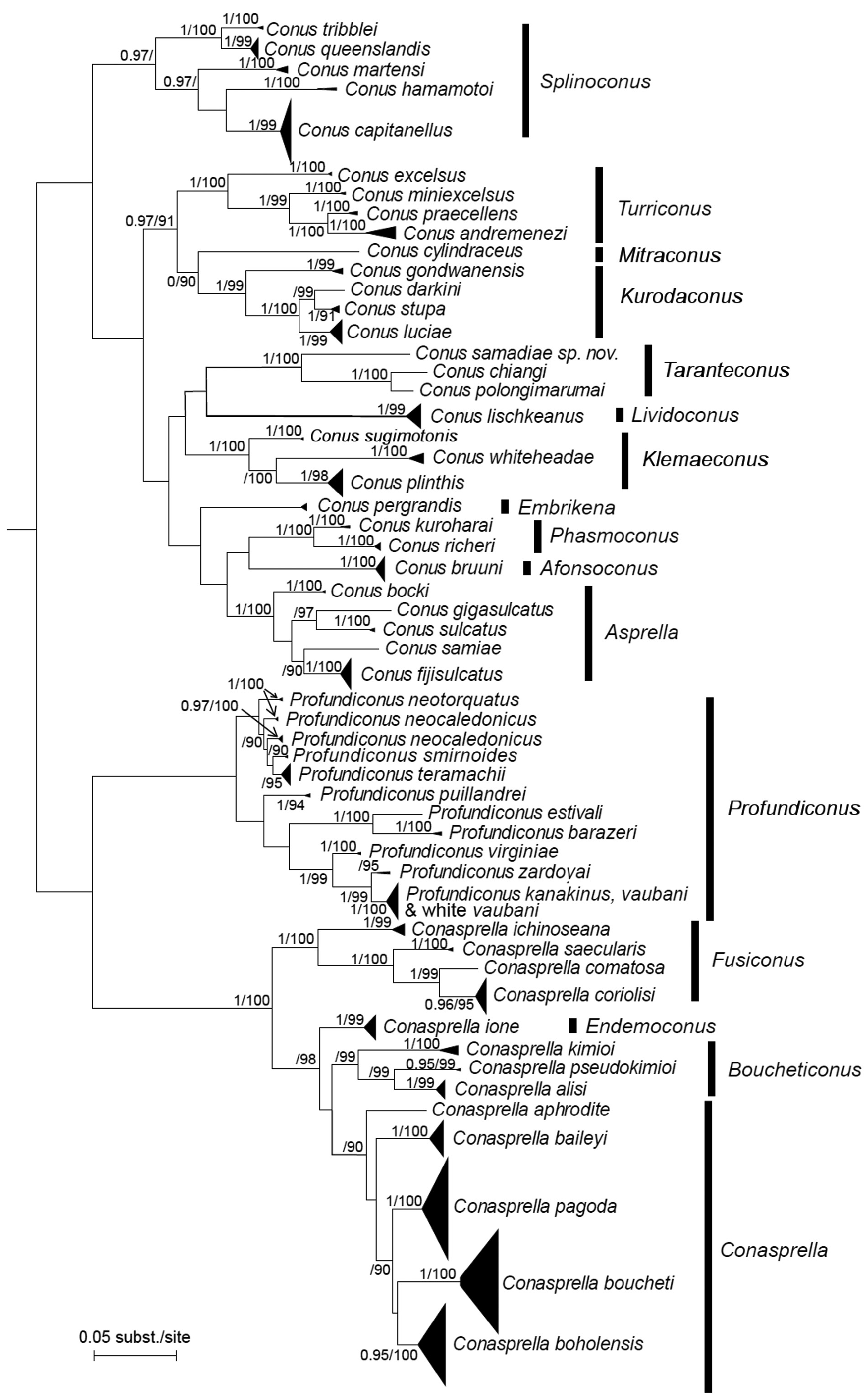
Small to medium-sized (maximum shell length 30 mm) conical shell with a carinate shoulder and moderately high spire of concave outline. Protoconch multispiral of about 3 whorls ( Fig. 34L View Fig ). Teleoconch sutural ramp with strong radial threads. There are 3 or 4 closely-set punctate spiral grooves just below the shoulder. Other than this, the last whorl can be essentially smooth, or variably covered with wide, axially striate spiral grooves. The typical shell pattern consists of about 6–8 broad brown spiral lines on the ribbons between the basal spiral grooves, but certain specimens also display interrupted brown bars and dashes or irregular brown blotches on the lavender-white area above the basal third. Radular tooth ( Fig. 34M View Fig ) with an indistinct barb and a pointed blade covering about one third of the anterior section, which is much shorter than the posterior section. Shaft fold present. Basal spur is present on top of the slanted base. This is a relatively abundant species in deep water around New Caledonia. In the phylogeny ( Fig. 2 View Fig ), all the sequenced specimens of C. boucheti form a well-supported clade which is sister to the other species of Conasprella .
| MNHN |
Museum National d'Histoire Naturelle |
No known copyright restrictions apply. See Agosti, D., Egloff, W., 2009. Taxonomic information exchange and copyright: the Plazi approach. BMC Research Notes 2009, 2:53 for further explanation.
|
Kingdom |
|
|
Phylum |
|
|
Class |
|
|
Order |
|
|
Family |
|
|
Genus |
Conasprella (Conasprella) boucheti ( Richard, 1983 )
| Tenorio, Manuel J. & Puillandre, Nicolas 2023 |
Conasprella boucheti
| Monnier E. & Limpalaer L. & Robin A. & Roux C. 2018: 196 |
Conus (Endemoconus) boucheti
| Richard G. 1983: 53 |
Conus
| Estival J-C. 1981: 110 |