
Oxynoemacheilus angorae ( Steindachner 1897 )
|
publication ID |
https://doi.org/10.11646/zootaxa.5133.4.1 |
|
publication LSID |
lsid:zoobank.org:pub:58A39822-32D1-4907-A866-7E75E5DA70A2 |
|
DOI |
https://doi.org/10.5281/zenodo.6533124 |
|
persistent identifier |
https://treatment.plazi.org/id/038FBA1C-256C-0C7D-FF22-FDD2EBF67E0E |
|
treatment provided by |
Plazi |
|
scientific name |
Oxynoemacheilus angorae ( Steindachner 1897 ) |
| status |
|
Oxynoemacheilus angorae ( Steindachner 1897) View in CoL
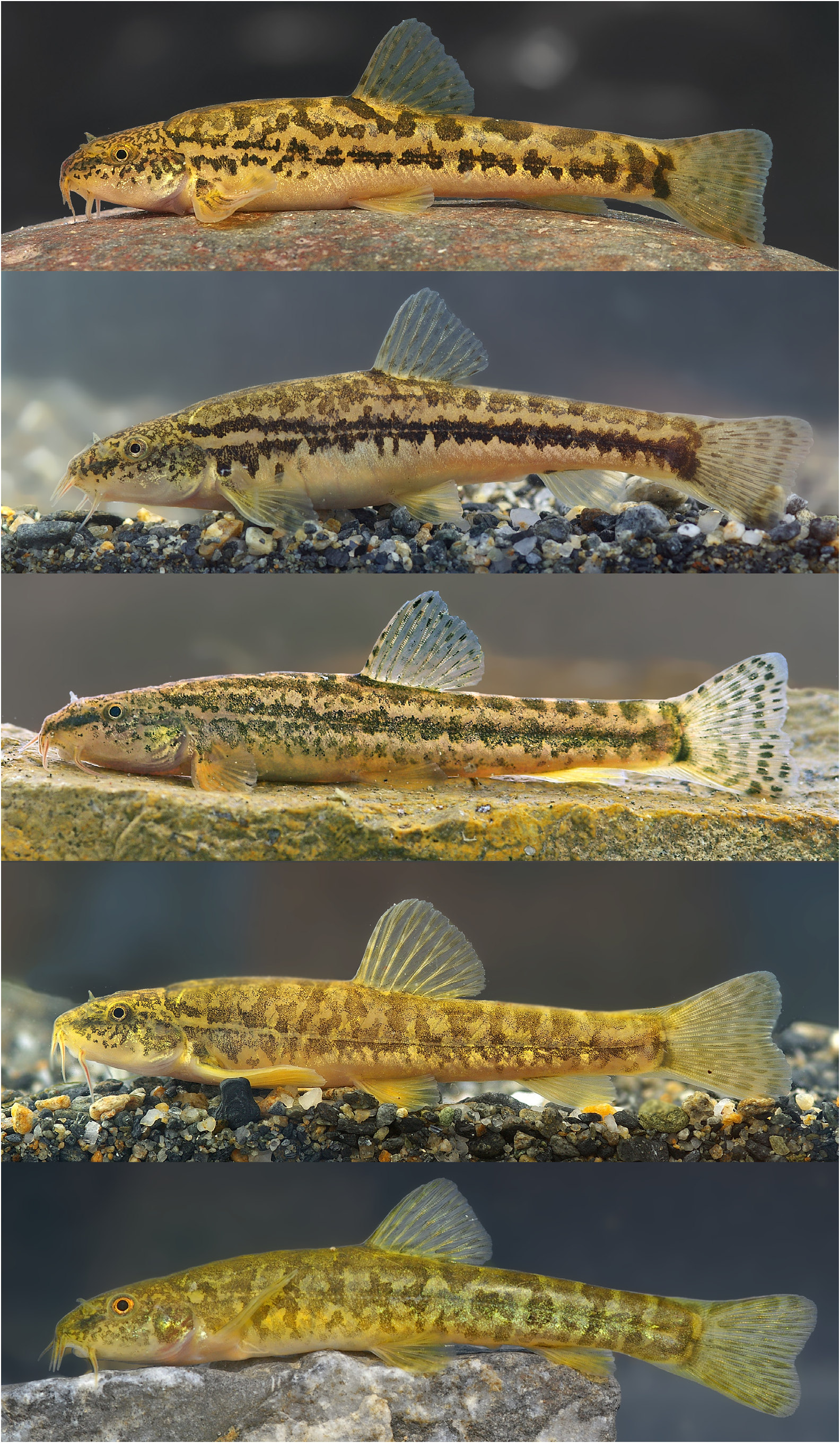
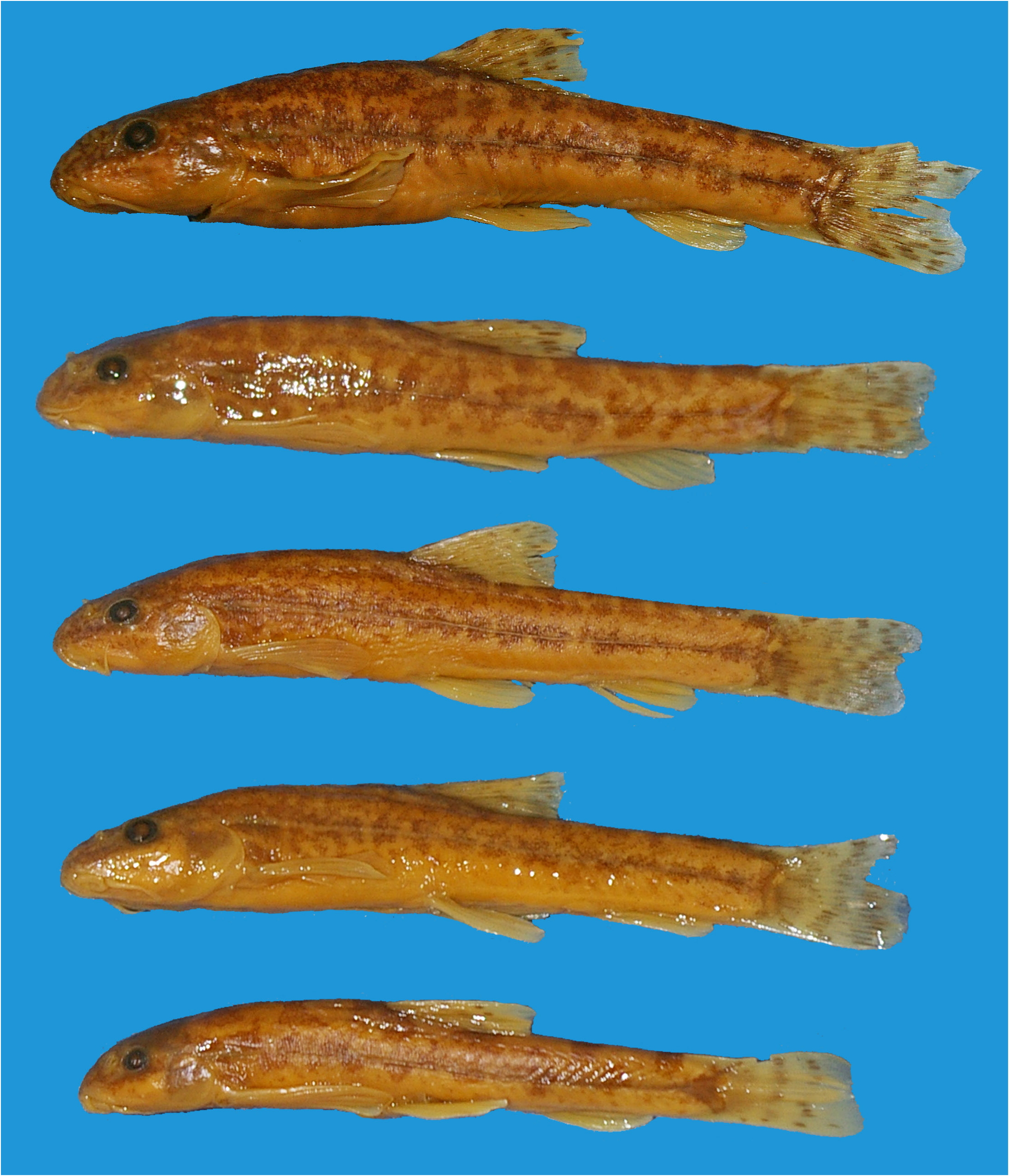
( Fig. 4 View FIGURE 4 )
Nemacheilus angorae Steindachner 1897:693 View in CoL [9], Pl. 4 ( Figs. 4a–c View FIGURE 4 ) ( type locality: Isparta prov.: Isparta Creek GoogleMaps , Eğirdir-Isparta Road, 1st railway pass, 37.6333 30.5166, Turkey)
Barbatula phoxinoides View in CoL Erk’akan, Nalbant & Özeren 2007:75, Fig. 6 View FIGURE 6 ( type locality: Bursa prov.: İznik , 40°41’N 29°30’E, Turkey.) GoogleMaps
Material examined. FFR 15591, 11, 49–74 mm SL; Turkey: Eskişehir prov.: Seydisuyu stream at bridge near Akin , 39.3376 30.5077.—FFR 15592, 3 GoogleMaps , 39–49 mm SL; Turkey: Çorum prov.: Çayır stream at bridge, 10 km east to Osmancık , 40.9786 34.9303.—FFR 15593, 1 GoogleMaps , 52 mm SL; Turkey: Çankırı prov.: Maruf upstream of Alpsarı Reservoir , 40.6777 33.4981.—FFR 15594, 4 GoogleMaps , 40–66 mm SL; Turkey: Çankırı prov.: Tatlıçay stream at Buğay , 40.7133 33.4933.—FFR 15595, 2 GoogleMaps , 45–49 mm SL; Turkey: Çorum prov.: Kızılırmak 2 km west to Osmancık , 40.9780 34.7758.—FFR 15596, 1 GoogleMaps , 39 mm SL; Turkey: Kırıkkale prov.: Kılıçözü stream near Takazlı , 39.6877 33.9321.— FFR 15597, 19 GoogleMaps , 35–63 mm SL; Turkey: Ankara prov.: Peçeneközü stream near Devekovan , 38.8666 33.7065.— FSJF 1939 , 29 GoogleMaps , 34–63 mm SL; Turkey: Eskişehir prov.: Pürtek stream at Mülkköy, a tributary of River Pursak , 39.5550 31.7583.— FSJF 1914 , 12 GoogleMaps , 46–65 mm SL; Turkey: Eskişehir prov.: stream Allıkova about 37 km south of Bozüyük, at road from Bozüyük to Kütahya, 39.6816 30.1540.— FSJF 1948 , 1 GoogleMaps , 52 mm SL; Turkey: Balıkesir prov.: Susurluk stream east of Susurluk , 39.9172 28.1656.— FSJF 1968 , 5 GoogleMaps , 54–64 mm SL; Turkey: Adapazarı ( Sakarya) prov.: Sakarya River at Şerefiye , 40.5959 30.3234.— FSJF 2400 , 25 GoogleMaps , 40–58 mm SL; Turkey: Bursa prov.: Çakırca stream at Çakırca, east of İznik Lake , 40.4625 29.6746.— FSJF 2498 , 17 GoogleMaps , 42–68 mm SL; Turkey: Ankara prov.: Öz stream at Kızılcahamam, east of Çeltikci , 40.3135 32.4670.— FSJF 2579 , 18 GoogleMaps , 49–65 mm SL; Turkey: Konya prov.: Deliköyboğazı stream 5 km south of Ilgın, at road to Beyşehir , 38.2356 31.8803.— FSJF 2878 , 23 GoogleMaps , 23–67 mm SL; Turkey: Sivas prov.: Yıldız stream between Yıldızeli and Sivas, 39.7585 36.7643.— FSJF 3090 , 3 GoogleMaps , 48–57 mm SL; Turkey: Konya prov.: Ilgın Lake , 38.3208 31.8903.— FSJF 3139 , 7 GoogleMaps , 33–52 mm SL; Turkey: Çorum prov.: Arkuç stream between Dodurga and Laçin, 40.7987 34.8567.— FSJF 3211 , 8 GoogleMaps , 86– 49 mm SL; Turkey: Konya prov.: Dereöz stream at Doğanhisar , 38.1356 31.6674.— FSJF 3731 , 18 GoogleMaps , 47–63 mm SL; Turkey: Çankırı prov.: Şabanözü stream 5 km south of Şabanözü , 40.4339 33.2835.— FSJF 3736 , 10 GoogleMaps , 31–59 mm SL; Turkey: Ankara prov.: stream flowing to Peçenek reservoir, 2 km east of Devekovan , 38.8667 33.7070 GoogleMaps .
New material used in molecular genetic analysis. FSJF-DNA 46 ; Eskişehir prov.: Pürtek stream at Mülkköy, a tributary of River Pursak , 39.5550 31.7583 ( GenBank accession numbers: ON123686 View Materials ) GoogleMaps .— FSJF-DNA 48 ; Turkey: Eskişehir prov.: Allıkova stream about 37 km south of Bozüyük , at road from Bozüyük to Kütahya, 39.6816 30.1540 ( GenBank accession numbers: ON123684 View Materials , ON123685 View Materials ) GoogleMaps .— FSJF-DNA 889 ; Turkey: Ankara prov.: Öz stream at Kızılcahamam, east of Çeltikci , 40.3135 32.4670 ( GenBank accession numbers: ON123682 View Materials , ON123683 View Materials ) GoogleMaps .— FSJF-DNA 2831; Turkey: Afyonkarahisar prov.: spring Başkurt 20 km southeast of Çifteler , 39.2660 31.1463 ( GenBank accession numbers: ON123696 View Materials ) GoogleMaps .
Additional distribution records. Yeğen et al. 2007: 38.4967 30.0828, 38.5503 30.2053, 39.0106 31.5594, 39.0842 31.3689, 39.1439 31.4136; Ilhan & Balık 2008: 38.9578 31.8313, 40.0903 31.8890, 40.9387 33.8949, 41.2217 34.1956, 41.2761 34.1874; Van Neer et al. 2008: 39.0482 31.3273, 39.3725 31.0697, 39.4146 31.1232, 39.5756 30.9066, 40.0318 31.4437, 40.1193 31.3260, 40.1328 31.6390, 40.3962 30.5044, 40.4118 29.7087, 40.5383 30.2988; Berber et al. 2011: 40.1613 28.6722; Erk’akan 2012: 40.0667 32.8667, 40.6833 29.5000; Ekmekçi & Yoğurtçuoğlu 2014: 39.0501 31.3234, 39.1465 31.9644, 39.1946 31.6216, 39.2086 32.0713; Geiger et al. 2014: 38.5353 32.4842, 40.4436 29.5167; Kelleci et al. 2021: 38.5913 33.5409; 38.6292 34.2985; Saylar et al. 2018: 40.1437 32.3889; Çiçek et al. 2019: 40.2038 33.0219, 40.3439 33.0389, 40.4038 29.3154; Turan et al. 2019: 38.2694 31.7036, 39.4175 31.5186, 40.3714 30.7128, 40.4822 32.6531; Aksu et al. 2020: 40.2829 28.6658, 40.3256 28.7569, 40.1710 28.9726, 40.2542 29.1505, 40.2334 29.2727, 40.2424 29.2948, 40.2257 29.3199; Sungur 2020: 38.3745 34.1754; Yoğurtçuoğlu et al. 2021a: 39.7376 30.5077; unpublished records: 38.8933 31.9750.
Diagnosis. Oxynoemacheilus angorae is distinguished from O. anatolicus and all other species of the O. angorae group by having a series of dark-brown midlateral blotches usually fused into a wide, irregular shaped midlateral stripe, rarely a mottled pattern (vs. a mottled or marbled pattern or a series of midlateral blotches or short bars not forming a stripe), and a depigmented stripe along the anterior part of the lateral line (vs. absent or very poorly expressed). Oxynoemacheilus angorae is further distinguished from O. anatolicus by having pre-dorsal back with a mottled or marbled pattern, rarely with distinct saddles (vs. pre-dorsal back usually with 3–4 large saddles, wider than interspace); and caudal peduncle depth 1.5–1.8 times in its length (vs. 1.3–1.6).
Distribution. Oxynoemacheilus angorae is widespread in the Simav, Sakarya and Kızılırmak River drainages as well as in Lake Ilgın and İznik basins in the Marmara and Black Sea basins.
Remarks. Based on our COI dataset, O. angorae is well separated from all other studied Oxynoemacheilus species, and by a minimum K2P distance of 3.0% to O. nasreddini , its closest relative. It is also supported as a distinct species by the PTP approach, but not by the mPTP delimitation. One of the analysed O. angorae individuals from the Sakarya River drainage (FSJF-DNA 2831) differ by a minimum 1.8 % K2P (and maximum 2.2 %) distance from the other O. angorae in our dataset. As we have only DNA of one individual from that population, it is recommended to re-visit the place and explore if an undescribed species might be involved.
No known copyright restrictions apply. See Agosti, D., Egloff, W., 2009. Taxonomic information exchange and copyright: the Plazi approach. BMC Research Notes 2009, 2:53 for further explanation.
|
Kingdom |
|
|
Phylum |
|
|
Class |
|
|
Order |
|
|
Family |
|
|
Genus |
Oxynoemacheilus angorae ( Steindachner 1897 )
| Yoğurtçuoğlu, Baran, Kaya, Cüneyt & Freyhof, Jörg 2022 |
Barbatula phoxinoides
| Erk'akan, F. & Nalbant, T. T. & Ozeren, S. C. 2007: 75 |
Nemacheilus angorae
| Steindachner, F. 1897: 693 |