
Aphanotorulus horridus ( Kner 1854 )
|
publication ID |
https://doi.org/10.11646/zootaxa.4072.5.1 |
|
publication LSID |
lsid:zoobank.org:pub:9C5743A5-6F97-471E-8F60-99A744193FE1 |
|
DOI |
https://doi.org/10.5281/zenodo.6055316 |
|
persistent identifier |
https://treatment.plazi.org/id/039887CC-FFD8-FF9D-94F1-4A10FC6D91D8 |
|
treatment provided by |
Plazi |
|
scientific name |
Aphanotorulus horridus ( Kner 1854 ) |
| status |
|
Aphanotorulus horridus ( Kner 1854)
( Fig. 11 View FIGURE 11 )
Hypostomus horridus Kner, 1854: 259 View in CoL , pl. 1 (fig. 1). Type locality: Forte do Principe am Rio Guaporé, Brazil. Syntypes (3): NMW 16325 (1), NMW 86604 (1). Originally proposed as Hyp. horridus View in CoL .
Plecostomus biseriatus Cope, 1872: 285 View in CoL . Type locality: the Amazon, between the mouth of the Rio Negro and the Peruvian Amazon or Ucayale River. Holotype: ANSP 8279.
Plecostomus scopularius Cope, 1871: 55 View in CoL . Type locality: the Amazon above the mouth of the Rio Negro. Lectotype: ANSP 8081, designated by Fowler (1915: 233); illustrated in Cope (1872a: pl. 16, no. 1).
Plecostomus virescens Cope, 1874: 137 View in CoL . Type locality: not explicitly given [Upper Amazon]. Syntypes: ANSP 21280 (4).
Material examined. Bolvia: AMNH 77469 (2), Rio Mamore; 8 kilometers north of Exaltacion, Depto Beni, Col. by S. Anderson, 29 September 1965; INHS 36997 (1), Rio Maniqui at San Borja, Beni, Bolivia; USNM 305509 (2), Rio Curiraba @ 10 km NE El Porvenir Biol. Sta., @ 40 Air km E San Borja, Dept. Beni, Ballivia Prov., - 14.917, -66.283, col. by W.C. Starnes, T.A. Monroe, J. Sarmiento, et al., 31 August 1987. Brazil: AMNH 12604 (1), Vicinity of mouth of Rio Macaua (tributary Rio Iaco), near Sena Madureira, 09º20’S, ca. 68º45’W, col. by B.A. Krukoff, 1934; ANSP 8081 (1), ( Holotype: Plecostomus scopularius, Cope 1871 ), Amazon River, above the mouth of the Rio Negro, R. Perkins; MCZ 33518 (2), Rio Jurua [vicinity of mouth of Rio Embira, trib. of Rio Tarauaca, in turn a trib. of Rio Jurua], Amazonas, col. by B.A. Krukoff, 1934; MCZ 33524 (2), Rio Purus [vicinity of mouth of Rio Macaua, trib. of Rio Iaco, in turn a tri. of Rio Purus], Acre, col. by B.A. Krukoff, 1933; MCZ 7794 (1),; MCZ 7799 (2), Tabatinga [Rio Solimoes at Tabatinga (aka Sapurara) and environs], Amazonas, THAYER 133, col. by D. Bourget, 1865; MCZ 7802 (2), Lago Cudajas [Lago Badajos], Amazonas, THAYER 0 25, col. by S.V.R. Thayer, D. Bourget, 1865; MCZ 7803 (2), Lago Manacapuru; Manacapuru [Lago Grande de Manacapuru], Amazonas, THAYER 0 60, col. by W. James, 1865; MCZ 7879 (3), Obidos; Obydos [Rio Amazonas at Obidos], Pará, THAYER 0 76, col. by Length Agassiz and party, 26 August 1865; MZUSP 23260 (1), Rio Solimões, Amazonas, 4º5’S 63º9’W, Expedição Permanente à Amazônia, 28 September 1968; MZUSP 28368 (2), Rio Machado, próximo à foz, Rondônia, 8º4ºS 62º54’W, Expedição Permanente à Amazônia, 21 November 1975; MZUSP 49682 (1), Rio Acre, Seringal Bom Destino (1 hora acima de Porto Acre), Acre, 9º36’S, 67º32’W, 19 October 1994; MZUSP 49839 (1), Rio Acre, seringal Perseverança, Rio Purus drainage, Acre,; MZUSP 50374 (1), Rio Juruá, Colocacão São João, Acre, 9º9’S, 72º41’W, 8 July 1993; MZUSP 50377 (1), Rio Tejo, Ponto 13, Foz Bajé, Acre, 8º56’S 72º34’W, 8 March 1994; MZUSP 50489 (1), Foz do São João, Rio Juruá, Acre, 9º9’S, 72º41’W, 18 July 1994; MZUSP 50491(1), Foz do Breu, Rio Juruá, Acre, 9º25’S 72º43’W, 21 July 1994; MZUSP 50494 (1), Foz do Tejo, Rio Juruá, Acre, 8º58’S 72º42’W, 15 July 1994; MZUSP 57622 (1), Rio Madeira, Amazonas, 3º49’54”S 59º3’58”W, col. by Zanata et al., 7 August 1996; MZUSP 60372 (1), Rio Aripuanã, Porto de Balsa (rio acima), estrada que liga o distrito de Colniza a Panelas, km 18, Aripuanã, Mato Grosso, 9º34’45”S 59º25’19”W, col. by F. Machado, C.H. Melo, C.M.C. Leite & M.F. Catarino; USNM 0 41540 (1), Manacapouru; USNM 308227 (2), Ressaca Da Ilha De Marchantaria, Amazonas, col. by P. Bayley, 2 March 1977. Colombia: FMNH 96065 (5), Amazon River 1 mi. upstream from Leticia, Amazonas, col. by Thomerson et al., 11 November 1973. Ecuador: USNM 177235 (1), Rio Cotapino, Trib. of the Suno, -0.708, -77.342, col. by J. Olalla, October 1950. Peru: ANSP 21280-83 (4), ( Syntypes: Plecostomus virescens Cope 1874 ), Upper Amazon, col. by Prof. James Orton; AUM 42001 (1), Rìo Tahuamanu, road crossing in vicinity of San Lorenzo, Madre de Dios, col. by M.H. Sabaj, Length Souza, M. Arce, Length deSouza, and N.J. Salcedo, 1 August 2004; AUM 45568 (1), Rìo Nieva, 7.4 km SSW Juan Velasco (Sta Maria de Nieva), Condorcanqui, Amazonas, col. by N.K. Lujan, D.C. Werneke, D.C. Taphorn, D.P. German, and D. Osorio, 5 August 2006; AUM 45585 (1), Rìo Marañon, pongo above Borja, 35.5 km NE Juan Velasco (Sta Maria de Nieva), Condorcanqui, Amazonas, col. by N.K. Lujan, D.C. Werneke, D.C. Taphorn, A.S. Flecker, K.A. Capps, D.P. German, and D. Osorio, 6 August 2006; FMNH 70157 (1), Madre de Dios: Rio Inambari, col. by E.R. Blake, 6 October 1958; INHS 36566 (1), Rio Napo at Mazan, Dept. Loreto, Peru; INHS 36796 (1), Iquitos, at fish market, Dept. Loreto, Peru; INHS 55406 (1), Rio Amazonas at beach along E bank of E channel opposite Iquitos, Dept. Loreto, Peru; MUSM 12628 (1), Tambopata, Rio Madre de Dios, El Bacon, Madre de Dio, Peru, 20 August 1997; MUSM 19897 (1), Tambopata, Rio Los Amigos, Madre de Dios, Peru, 17 August 2001; MUSM 26699 (1), Alto Amazonas, Trompeteros, Rio Corrientes, Loreto, Peru, 20 October 2005; MUSM 9976 (1), Tambopata, lago Valencia, Madre de Dios, Peru, 24 October 1995; MZUSP 26754 (1), Rio Aguaytia, Nuevo Requena, Pucallpa, col. by H. Ortega, 23 October 1973; MZUSP 26788 (1), Rio Neshuya, estrada Pucallpa- Huanuco, Pucallpa, Ucayali, col. by H. Ortega, 24 July 1978; MZUSP 26789 (2), Yarinacocha, Pucallpa, Cel. Portillo, Ucayali, col. by H. Ortega, 10 August 1973; UF 126268 (1), Cano Puinahua, opposite mouth of Rio Pacaya. Habitat - Beaches & Muddy bottom, Loreto, col. by J.S. Albert et al., 23 September 2002; USNM 0 86834 (2), Yurimaguas, Rio Paranapura, col. by W.R. Allen, November 1920; USNM 123268 (1), Rio Morona, col. by W.R. Allen, October 1920; USNM 124911 (2), Shansho Cano, col. by W.G. Scherer, 18 October 1935; USNM 167886 (1), Yurimaguas, Rio Huallaga, col. by W.R. Allen, November 1920; USNM 167887 (2), Iquitos, Loreto Region, col. by W.R. Allen, September 1920; USNM 167888 (1), Yurimaguas, Rio Paranapura, col. by W.R. Allen, November 1920; USNM 263916 (3), Madre De Dios; Rio Tambopata, Opposite Boat Landing For Explorer'S Inn., Madre de Dios Region, - 12.833 S, - 69.300 W, col. by H. Ortega, R.P. Vari, 21 August 1983; USNM 263919 (1), Shore of Isla About 15 km Downriver of Junction of Rio Tambopata and Rio Madre De Dios., Madre de Dios Region, - 12.500 S, - 69.147 W, col. by R.P. Vari, H. Ortega, S.L. Jewett, 25 August 1983; USNM 350530 (1), Department Madre De Dios: Parque Nacional Manu, Pakitza and Vicinity, Madre de Dios Region, col. by H. Ortega, October 1987. Unknown: ANSP 8279 (1), Amazon River, col. by R.C. Perkins.
Diagnosis. Aphanotorulus horridus can be diagnosed from A. ammophilus and A. unicolor by a single, large buccal papillae (vs. multiple buccal papillae); from A. emarginatus by having a smaller snout-nares distance to interorbital width ratio (70.5– 97.8% vs. 98.0– 175.4%), which separates 92% of individuals ( Fig. 2 View FIGURE 2 ); from A. phrixosoma by having fewer elongate hypertrophied covering the dorsal and ventral surfaces of body except the head (vs. many hypertrophied odontodes present—see A. phrixosoma description); and from A. gomesi only by range. Aphanotorulus horridus can be further diagnosed from I. spinosissima and I. tenuicauda by having flat compound pterotics (vs. rounded ridges on the compound pterotics in I. spinosissima and I. tenuicauda and sharp ridge present in I. villarsi ); from I. spinosissima by having a larger caudal fin depth to head length ratio (see diagnosis of I. spinosissima ); from I. acuarius by having a supraoccipital crest with posterior edge gently sloping into nape (vs. I. acuarius with posterior edge perpendicular to head).
Description. Morphometric data given in Table 3 View TABLE 3 . Head moderately deep with elevated supraoccipital crest; supraoccipital crest taller than nape and posterior edge of crest gently sloping into nape. Nape flat.
Pectoral-fin spine reaches posterior to insertion of pelvic fin. Pelvic-fin spine reaches insertion of anal-fin spine. Two plates separate adipose-fin membrane and first dorsal procurrent caudal fin spine.
Lateral line plates 27–30 (mode 28; n= 73); dorsal-fin base plates six to eight (mode seven; n= 73); folded dorsal plates 10–14 (mode 12; n= 72); plates between dorsal and adipose fin six to 11 (mode nine; n= 73); adipose fin plates one to four (mode three; n= 73); anal fin base plates one to three (mode two; n= 73); plates from anal fin insertion to last plate on caudal peduncle 13–19 (mode =17; n =73); plates in folded pectoral fin four to eight (mode six; n =72); number of teeth on dentary 10–42 (mode =27; n =73); number of teeth on premaxilla nine to 37 (mode =22; n =73).
Sexual Dimorphism. Breeding males with short hypertrophied odontodes on ventral surfaces of body except head. Odontodes on body short; only on posterior edges of plates. Odontodes present on pectoral- and caudal-fin spines; odontodes increase in density and length distally on each fin spine. Hypertrophied odontodes absent from pelvic, dorsal, and adipose fin spines.
Color in alcohol. Light tan background color with brown spots. Small spots covering head, increasing in size and becoming more elongate posteriorly along the body. In adults, spots begin to fuse together on head to create lines with reticulated patterns; largest specimens with mostly reticulated lines present, few spots remaining. Some specimens with small spots on ventral side of body along pectoral girdle. Paired fins with elongate spots, usually forming bands on fins. Dorsal fins in adults with elongate spots forming bands. Small, random spotting pattern apparent on adipose fin. Lower half of caudal fin rays darker in color than base color, dark coloration not extending to lower caudal spine.
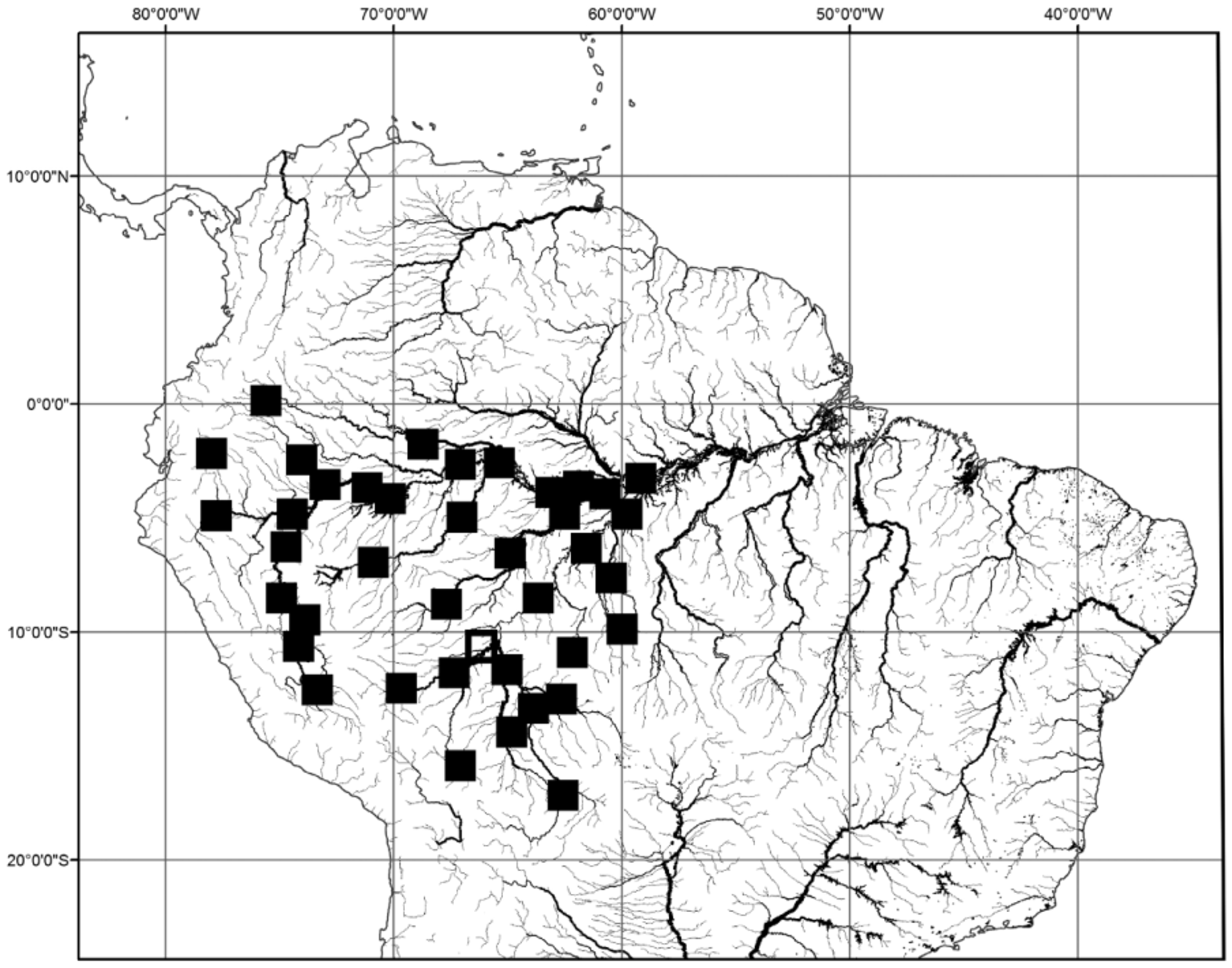
Distribution. Aphanotorulus horridus is found in the upper Amazon River, including the mainstem, Rio Napo, Rio Marañon, Rio Ucayali, Rio Juruá, Rio Purus, and Rio Madiera ( Fig. 12 View FIGURE 12 ).


| AMNH |
American Museum of Natural History |
| INHS |
Illinois Natural History Survey |
| USNM |
Smithsonian Institution, National Museum of Natural History |
| ANSP |
Academy of Natural Sciences of Philadelphia |
| MCZ |
Museum of Comparative Zoology |
| MZUSP |
Museu de Zoologia da Universidade de Sao Paulo |
| FMNH |
Field Museum of Natural History |
| AUM |
Auburn University Museum of Natural History |
No known copyright restrictions apply. See Agosti, D., Egloff, W., 2009. Taxonomic information exchange and copyright: the Plazi approach. BMC Research Notes 2009, 2:53 for further explanation.
|
Kingdom |
|
|
Phylum |
|
|
Class |
|
|
Order |
|
|
Family |
|
|
Genus |
Aphanotorulus horridus ( Kner 1854 )
| Ray, C. Keith & Armbruster, Jonathan W. 2016 |
Plecostomus virescens
| Cope 1874: 137 |
Plecostomus biseriatus
| Cope 1872: 285 |
Plecostomus scopularius
| Cope 1871: 55 |
Hypostomus horridus
| Kner 1854: 259 |