
Tetramorium signatum Emery, 1895
|
publication ID |
https://doi.org/ 10.5852/ejt.2018.454 |
|
publication LSID |
lsid:zoobank.org:pub:07F6B28D-ECA4-4F14-8132-0A58DE156057 |
|
DOI |
https://doi.org/10.5281/zenodo.3818718 |
|
persistent identifier |
https://treatment.plazi.org/id/039887DC-FFBF-A440-2B6D-A57EFDF5A72F |
|
treatment provided by |
Valdenar |
|
scientific name |
Tetramorium signatum Emery, 1895 |
| status |
|
Tetramorium signatum Emery, 1895 View in CoL
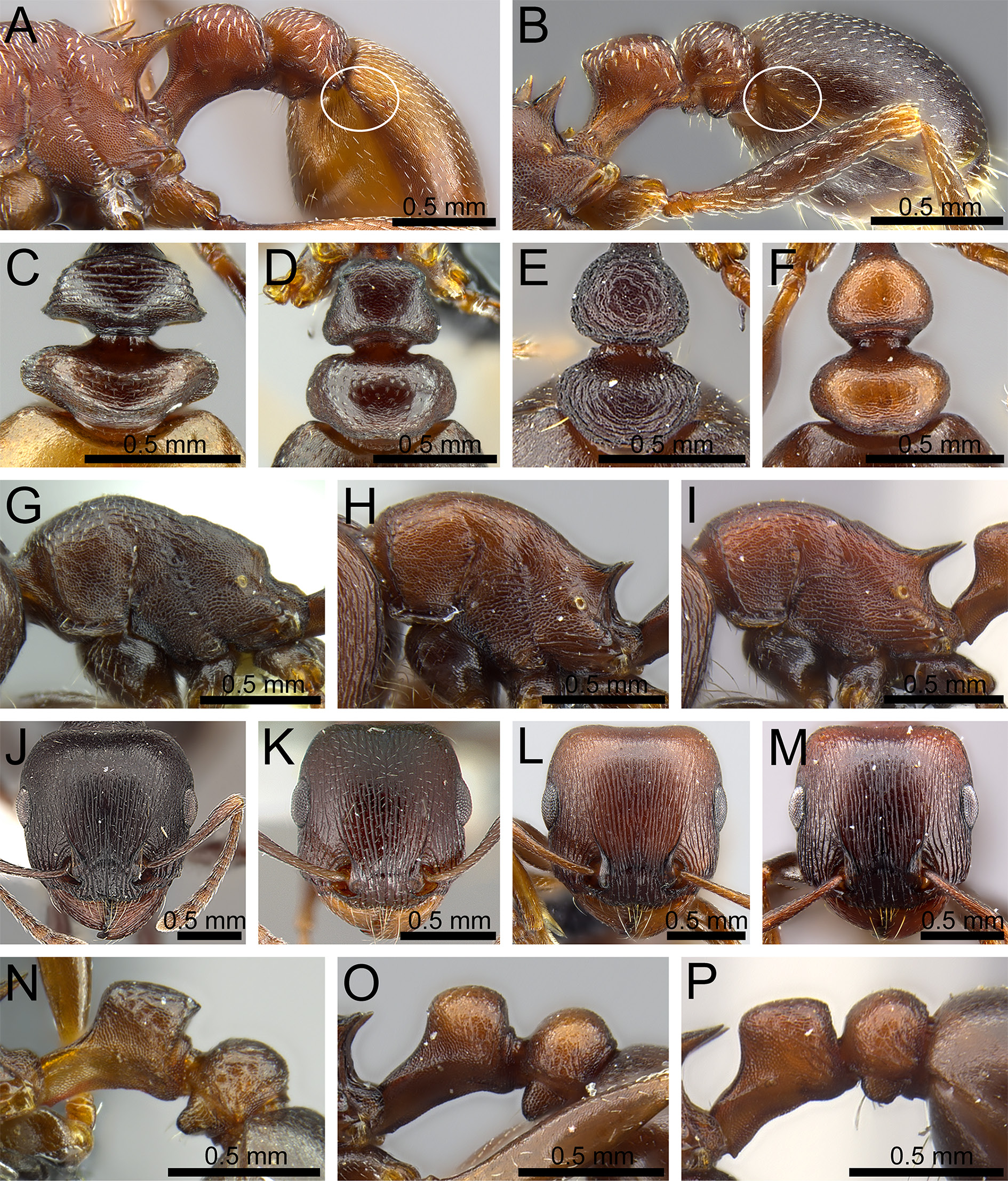
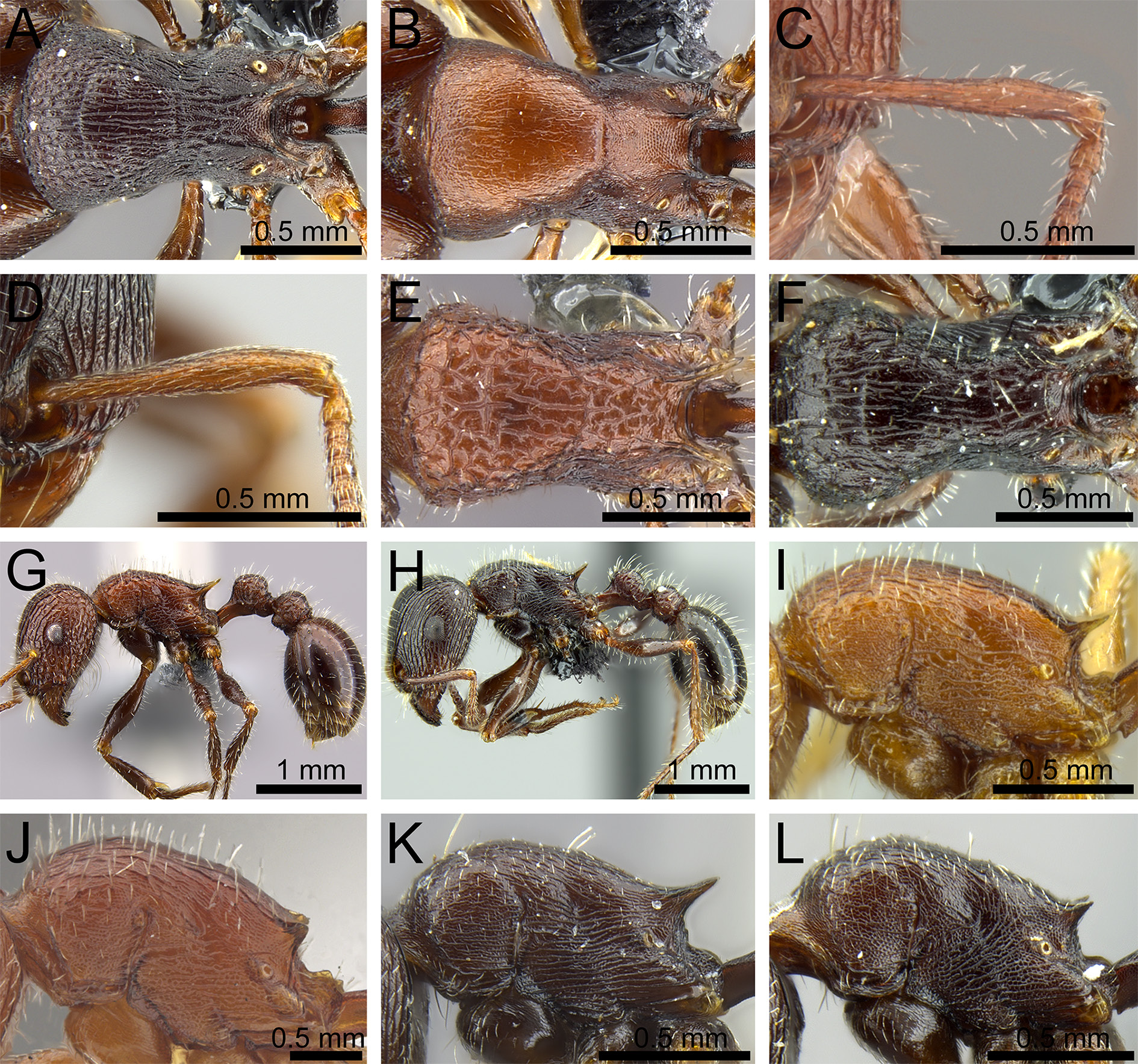
Figs 3E View Fig , 4A View Fig , 22 View Fig , 24 View Fig
Tetramorium solidum var. signatum Emery, 1895: 35 View in CoL View Cited Treatment (included in Bolton 1980: 251).
Tetramorium solidum subsp. lugrubre Forel, 1910: 425 (included in Bolton 1980: 251).
Tetramorium solidum var. grootensis Forel, 1913: 118 (included in Bolton 1980: 251).
Tetramorium solidum var. tuckeri Arnold, 1926: 259 (included in Bolton 1980: 251).
Diagnosis
Tetramorium signatum is similar to T. rufescens and T. pogonion . Tetramorium pogonion is relatively smaller compared to the other two species with relatively larger eyes (OI> 30) and a different head shape ( Fig. 3K View Fig ). Tetramorium signatum and T. rufescens can be separated on basis of the sculpture pattern on the dorsum of mesosoma. In T. signatum , the dorsum of the mesosoma has distinct longitudinal or irregular rugulae ( Fig. 4A View Fig ), whereas in T. rufescens , the dorsum of the mesosoma has a dense reticulate punctation and sometimes with a few short faint longitudinal costulae ( Fig. 4B View Fig ).
Material examined
Type material
SOUTH AFRICA: syntype of Tetramorium solidum var. signatum Emery, 1895: 1 pinned worker, Western Cape, Matjiesfontein, E. Simon leg. ( MSNG: CASENT0904841 ); syntypes of Tetramorium solidum var. grootensis Forel, 1913: 1 pinned queen, 1 pinned ♂, Eastern Cape, Willowmore, H. Brauns leg. ( BMNH: CASENT0901188 ; MHNG: CASENT0909156 ).
ANGOLA: syntype of Tetramorium solidum subsp. lugrubre Forel, 1910: 1 pinned worker, Mossamedes , de Picard leg. ( MHNG: CASENT0909157 ).
NAMIBIA: syntypes of Tetramorium solidum var. tuckeri Arnold, 1926: 1 pinned queen, 1 pinned worker, Brehdon , 20 Dec. 1915, R.W.E. Tucker leg. ( BMNH: CASENT0901189 ; SAMC: SAM-ENT-0011762).
Other material
SOUTH AFRICA (262 pinned specimens): Northern Cape: Dreghorn , 26.85755° S, 20.78949° E, 862 m a.s.l., 17 Dec. 2007, N. Mbanyana and H.G. Robertson leg. (SAM-HYM-C019926); GoogleMaps Dreghorn , 26.85755° S, 20.78949° E, 862 m a.s.l., 17 Dec. 2007, N. Mbanyana and H.G. Robertson leg. ( SAM- HYM-C019927); GoogleMaps Cullinan Farm , 26.34087° S, 22.61083° E, 977 m a.s.l., 19 Dec. 2007, N. Mbanyana and H.G. Robertson leg. (SAM-HYM-C019928 to SAM-HYM-C019932); GoogleMaps Cullinan Farm, 26.34087° S, 22.61083° E, 977 m a.s.l., 19 Dec. 2007, N. Mbanyana and H.G. Robertson leg. (SAM-HYM-C019933 to SAM-HYM-C019937); GoogleMaps Cullinan Farm , 26.85770° S, 20.78656° E, 855 m a.s.l., 17 Dec. 2007, N. Mbanyana and H.G. Robertson leg. (SAM-HYM-C019938); GoogleMaps between Askham and Vansylsrus, 27.03322° S, 21.09746° E, 872 m a.s.l., 18 Dec. 2007, nest entrance with crater of soil around entrance, N. Mbanyana and H.G. Robertson leg. (SAM-HYM-C019939); GoogleMaps Cullinan Farm , 26.33562° S, 22.61217° E, 962 m a.s.l., 17 Dec. 2007, N. Mbanyana and H.G. Robertson leg. (SAM-HYM-C019940); GoogleMaps Cullinan Farm, 26.34087° S, 22.61083° E, 977 m a.s.l., 19 Dec. 2007, N. Mbanyana and H.G. Robertson leg. (SAM-HYM-C027128); GoogleMaps Loeriesfontein (SAM-HYM-C019277); Loeriesfontein ( SAM- HYM-C019283); Rietfontein Oos (SAM-HYM-C019284); road between Karsten Farms and Goodhouse, Kokerboom site, Klein Pella , 29.06211° S, 18.97985° E, 832 m a.s.l., 16 Dec. 2007, Gariep rocky desert with Kokerboom and Euphorbi a, N. Mbanyana and H.G. Robertson leg. (SAM-HYM-C019946, SAM- HYM-C019954); GoogleMaps road between Karsten Farms and Goodhouse, Kokerboom site, Klein Pella , 29.03527° S, 18.97662° E, 678 m a.s.l., 16 Dec. 2007, east desert with large Eurphobia trees, N. Mbanyana and H.G. Robertson leg. (SAM-HYM-C019955); GoogleMaps road between Karsten Farms and Goodhouse, Euphorbia site, Klein Pella , 29.03527° S, 18.97662° E, 678 m a.s.l., 16 Dec. 2007, east Gariep desert with large Euphorbia , soil around the entrance, N. Mbanyana and H.G. Robertson leg. (SAM-HYM-C019956); GoogleMaps road from Klein Pella to Orange River , 28.95083° S, 18.199153° E, 449 m a.s.l., Gariep plain desert, 16 Dec. 2007, sandy soil with gravel, shallow soil, found foraging on ground, N. Mbanyana and H.G. Robertson leg. (SAM-HYM-C019957); GoogleMaps Goegab Nature Reserve , Jul. 1998, U. Kruger leg. (SAM-HYM-C013303); Brandvlei , 30°31′ S, 20°29′ E, 28 May 1986, A.J. Prins leg. (SAM-HYM-C001716); GoogleMaps Dreghorn near Chalets , 26.85770° S, 20.78656° E, 855 m a.s.l., 17 Dec. 2007 (SAM-HYM-C019904, SAM-HYM-C019905, SAM-HYM-C019907, SAM-HYM-C019921); GoogleMaps Dreghorn , 26.85755° S, 20.78949° E, 862 m a.s.l., 17 Dec. 2007, N. Mbanyana and H.G. Robertson leg. (SAM-HYM-C019922, SAM-HYM-C019925); GoogleMaps Hopetown, 4 km E of Hopetown , Hopetown Municipal Farm , 15 Feb. 1992, B. Chambers leg. (SAM-HYM-C010856); road between Karsten Farms and Goodhouse, 29.06211° S, 18.97985° E, 832 m a.s.l., 16 Dec. 2007, N. Mbanyana and H.G. Robertson leg. (SAM-HYM-C019868); GoogleMaps Mokala National Park, Lilydale Lodge , 29.06377° S, 24.47202° E, 602 m a.s.l., 12 Jan. 2009, N. Mbanyana and H.G. Robertson leg. (SAM-HYM-C023331); GoogleMaps Tankwa Karoo National Park , 32.17430° S, 19.97382° E, 602 m a.s.l., 7 Jan. 2009, N. Mbanyana and H.G. Robertson leg. (SAM-HYM-C023332, SAM-HYM-C023324); GoogleMaps Mokala National Park, Lilydale Lodge , 29.06377° S, 24.47202° E, 602 m a.s.l., 12 Jan. 2009, N. Mbanyana and H.G. Robertson ( SAM- HYM-C023310); GoogleMaps Mokala National Park, 29.14467° S, 24.28437° E, 1185 m a.s.l., 12 Jan. 2009, N. Mbanyana and H.G. Robertson leg. (SAM-HYM-C023311); GoogleMaps Kimberley (SAM-HYM-C004019); Melton Wold , 31.46626° S, 22.72004° E, 1332 m a.s.l., 9 Jan. 2009, N. Mbanyana and H.G. Robertson leg. (SAM-HYM-C023315, SAM-HYM-C023316); GoogleMaps Tankwa Karoo National Park, 32.17430° S, 19.97382° E, 490 m a.s.l., 7 Jan. 2009, N. Mbanyana and H.G. Robertson leg. (SAM-HYM-C023317, SAM-HYM-C023318); GoogleMaps Melton Wold, 31.46741° S, 22.721550° E, 1333 m a.s.l., 7 Jan. 2009, N. Mbanyana and H.G. Robertson leg. (SAM-HYM-C023320); GoogleMaps Tankwa Karoo National Park , 32.17430° S, 19.97382° E, 602 m a.s.l., 7 Jan. 2009, N. Mbanyana and H.G. Robertson leg. ( SAM- HYM-C023322, SAM-HYM-C023325, SAM-HYM-C023327, SAM-HYM-C023328); GoogleMaps Dreghorn near Chalets, 26.85770° S, 20.78656° E, 855 m a.s.l., 17 Dec. 2007, nest in soil underground, nest entrance at base of grass tuft, N. Mbanyana and H.G. Robertson leg. (SAM-HYM-C024391); GoogleMaps Kortkop Farm, near Strydenburg , 30°09′ S, 23°44′ E, 17 Jun. 1995, pitfall trap, Karoo vegetation, B. Chambers leg. ( SAM- HYM-C008768); GoogleMaps Tankwa Karoo National Park , 32.21512° S, 20.07671° E, 522 m a.s.l., 7 Jan. 2009, N. Mbanyana and H.G. Robertson leg. (SAM-HYM-C023321); GoogleMaps Tankwa Karoo National Park , 32.24758° S, 20.09660° E, 490 m a.s.l., 7 Jan. 2009, N. Mbanyana and H.G. Robertson leg. ( SAM- HYM-C023319); GoogleMaps Tankwa Karoo National Park , 32.42325° S, 19.98843, 379 m a.s.l., 7 Jan. 2009, N. Mbanyana and H.G. Robertson leg. (SAM-HYM-C023326); Kalahari Gemsbok National Park, Gemsbokplain waterhole and dung, 26°09.1′ S, 20°31.8′ E, 935 m a.s.l., 21 Nov. 1997, M. Uhlig leg. (SAM-HYM-C011358); GoogleMaps Namakwaland, Gamsberg 2009 transect v4 -s7-t1, 29.22153° S, 18.97957° E, 959 m a.s.l., hand collected, 5 Sep. 2009, P. Hawkes and J. Fisher leg. ( CASC: CASENT0250961 ). GoogleMaps – Western Cape: Ladismith (SAM-HYM-C019279); Onder-Downs (SAM-HYM-C019282); 33 km from Prince Albert Road on Leeu Gama Road , 32°56′ S, 21°59′ E, 10–19 Oct. 1996, T.E. Tshiguvho leg. (SAM-HYM-C009330); GoogleMaps 40 km from Seekoegat on Prince Albert Road , 33°10′ S, 22°10′ E, 10–19 Oct. 1996, T.E. Tshiguvho leg. (SAM-HYM-C009331); GoogleMaps 2 km from Prince Albert Road on Leeu Gamka road, 33°11′ S, 22°02′ E, 10–19 Oct. 1996, T.E. Tshiguvho leg. (SAM-HYM-C009332); GoogleMaps Josephskraal, 33.04182° S, 20.72157° E, 896 m a.s.l., 16 Apr. 2008, Koedoesberge-Moordenaars Karoo , nesting in soil under rock, N. Mbanyana and H.G. Robertson leg. (SAM-HYM-C020573); GoogleMaps Abrahamskraal , 32.92874° S, 22.00435° E, 522 m a.s.l., 12 Apr. 2008, drainage line with deep soils soft at about 20 cm and after that harder and compacted, nesting in soil under rock, N. Mbanyana and H.G. Robertson leg. (SAM-HYM-C020506, SAM-HYM-C020510, SAM-HYM-C020513); GoogleMaps Abrahamskraal, 32.93011° S, 22.00949° E, 522 m a.s.l., 12 Apr. 2008, rocky ridges with sparsely distributed shrubs, shallow soil, N. Mbanyana and H.G. Robertson leg. (SAM-HYM-C020330, SAM-HYM-C020335, SAM- HYM-C020344); GoogleMaps Gamkaskloof, 33°21′48″ S, 21°37′39″ E, 24 Oct. 2005, Nama Karoo rocky hillside, N. Mbanyana and H.G. Robertson leg. (SAM-HYM-C019028); GoogleMaps Gamkaskloof, 33°21′48″ S, 21°37′39″ E, 25 Oct. 2005, Nama Karoo rocky hillside, N. Mbanyana and H.G. Robertson leg. ( SAM- HYM-C019033); GoogleMaps Vêrgenoeg, 33.24421° S, 21.47939° E, 670 m a.s.l., 10 Apr. 2008, Koedoesberge-Moordenaars Karoo , N. Mbanyana and H.G. Robertson leg. (SAM-HYM-C020400); GoogleMaps Vêrgenoeg, 33.24467° S, 21.47597° E, 670 m a.s.l., 10 Apr. 2008, Koedoesberge-Moordenaars Karoo , east-facing rocky slope, N. Mbanyana and H.G. Robertson leg. (SAM-HYM-C020431); GoogleMaps Josephskraal, 33.04182° S, 20.72157° E, 896 m a.s.l., 16 Apr. 2008, Koedoesberge-Moordenaars Karoo , found nesting in deep soil on elevated flood plain, N. Mbanyana and H.G. Robertson leg. (SAM-HYM-C020469, SAM- HYM-C020452); GoogleMaps Vrede, Anysberg Nature Reserve , Karoo vegetation, 33°28′00″ S, 20°35′00″ E, 27 Feb. 1999, foraging in front of a bungalow, H.G. Robertson leg. (SAM-HYM-C013034); GoogleMaps Vrede, Anysberg Nature Reserve , 33°28′00″ S, 20°35′00″ E, 27 Feb. 1999, Karoo vegetation, foraging on sandy soils near river (SAM-HYM-C013039); GoogleMaps Prince Albert, Tierberg Research Station , 33.168833° S, 22.270111° E, 740 m a.s.l., 14 Feb. 2006, succulent Karoo , pitfall trap, Iimbovane Outreach Project , B. Braschler leg. (SAM-HYM-C024974); GoogleMaps Vêrgenoeg, 33.23126° S, 21.46445° E, 630 m a.s.l., 10 Apr. 2008, Koedoesberge-Moordenaars Karoo , Karoo plain with succulent components mainly mesems ( Aizoaceae ), nest with at least 15 entrances covering about half a meter square, N. Mbanyana and H.G. Robertson leg. (SAM-HYM-C020539, SAM-HYM-C020546); GoogleMaps Josephskraal, 33.04287° S, 20.7193° E, 900 m a.s.l., 16 Apr. 2008, Koedoesberge-Moordenaars Karoo , Karoo plain slightly N-facing, N. Mbanyana and H.G. Robertson leg. (SAM-HYM-C020436); GoogleMaps Die Hell, Synamn Hut , 33°21′49″ S, 21°37′39″ E, 25 Oct. 2005, A. MacArthur leg. (SAM-HYM-C019522); GoogleMaps Namakwa Sands, 31°16′14.1″ S, 17°56′23.7″ E, 31 Mar.–4 Apr. 2003, natural vegetation, Strandveld , pitfall traps, N. Ndivhuwo leg. (SAM-HYM-C018093, SAM-HYM-C018097). GoogleMaps – Eastern Cape: Willowmore, 1 Jan. 1914, Rhodesia Museum (SAM-HYM-C004017); Willowmore, Oct. 1912, Dr H. Brauns leg. (SAM-HYM-C004018); 16 km N of Willowmore on Brakfontein Farm , 33°09′ S, 23°26′ E, sand, Karoo scrub, nesting on ground partly under rock, 5 Sep. 1988, H.G. Robertson leg. (SAM-HYM-C005328); GoogleMaps Aberdeen, 27 May 1987, A.J.Prins andA. Roux leg.(SAM-HYM-C001686); Vanrhyns Pass , 24Aug.1963 (SAM-HYM-C004122); Brandkop , 22 Apr. 1963 (SAM-HYM-C004124); Blomplaas, 60 km SE of Aberdeen, 32°52′ S, 23°40′ E, 5 Sep. 1988, bare ground on Karoo scrub, nesting underground, H.G. Robertson leg. ( SAM- HYM-C001317); GoogleMaps 16 km N of Willowmore on Brakfontein Farm , 33°09′ S, 23°26′ E, 5 Sep. 1988, sand, Karoo scrub, nest partly under rock, partly underground, H.G. Robertson leg. (SAM-HYM-C001311). GoogleMaps
NAMIBIA: 61.2 km S of Gobabis on C20, at intersection of C20 and D1790, 23°44.908′ S, 18°50.987′ E, 1246 m a.s.l., nesting in deep red-orange sandy soils, nest with a crater of soil around entrance, 17 Apr. 2011, N. Mbanyana and H.G. Robertson leg. (SAM-HYM-C027005); GoogleMaps 31 km NW of Henties Bay on C35, 21°55.433′ S, 14°25.164′ E, nesting in loose gravely soil, entrance in open, 9 Apr. 2011, N. Mbanyana and H.G. Robertson leg. (SAM-HYM-C027007); GoogleMaps Klein-Aus-Vista , 26°39.221′ S, 16°14.532′ E, 1325 m a.s.l., rocky N-facing slope with low shrubs and grass, soil shallow and gravelly, 5 Apr. 2011, N.Mbanyana and H.G.Robertson leg.(SAM-HYM-C027009); GoogleMaps 157km from Gobabis on C20, 23°44.908′S, 18°50.987′ E, 17 Apr. 2011, entrance with crater of soil around, N. Mbanyana and H.G. Robertson leg. (SAM-HYM-C027011); GoogleMaps Klein-Aus Vista , 26°39.198′ S, 16°14.542′ E, 1273 m a.s.l., 3 Apr. 2011, nest in rocky sand soil at base of dead grass tuft in middle of dry riverbed, entrance with crater of soil around it (SAM-HYM-C026892, SAM-HYM-C027012); GoogleMaps Klein-Aus Vista, 26°39.143′ S, 16°14.546′ E, 1316 m a.s.l., 4 Apr.2011, nest in rocky sands, with about four entrances closer to each other with crater of soil around entrance (SAM-HYM-C027015); GoogleMaps Marienfluss, Koakoveld , 17°23′38.4″ S, 12°29′59.2″ E, 15 Oct. 2008, M. Picker leg. (SAM-HYM-C023244); GoogleMaps Kakamas, Orange River , National Museum of South Rhodesia leg. (SAM-HYM-C004019); Marienfluss, Koakoveld , 17°23′38.4″ S, 12°29′59.2″ E, 15 Oct. 2008, M. Picker leg. (SAM-HYM-C027002); GoogleMaps Gamsberg, 29.22153° S, 18.97953° E, 929 m a.s.l., 15 Dec. 2007, P. Hawkes and J. Fisher leg. (SAM-HYM-C024382); GoogleMaps Diamond Area 1, 27°17′ S, 15°58′ E, 2–3 Nov. 1986, pitfall traps, E. Griffin leg. (SAM-HYM-C027111); GoogleMaps Keetmanshoop District, Khabus 146, 26°18′ S, 18°13′ E, on sandy plain next to dry riverbed, 14 Apr.–30 Jun. 1988, N. and G. Olivier leg. (SAM-HYM-C027177); GoogleMaps Keetmanshoop District, Khabus 146, 26°17′ S, 18°14′ E, on dolerite hill, E slope, pitfall traps, 23 Jul.–1 Oct. 1988, N. and G. Olivier leg. (SAM-HYM-C027180); GoogleMaps Diamond Area 1, 28°12′ S, 16°49′ E, 14–29 Sep. 1994, pitfall traps, E. Marais leg. (SAM-HYM-C027182); GoogleMaps Klein Aus 10, Luderitz District , 26°38′ S, 16°10′ E, 12–26 Nov. 1993, E. Marais leg. (SAM-HYM-C027185); GoogleMaps Keetmanshoop District, Khabus 146, 26°18′ S, 18°13′ E, on sandy plain next to riverbed, 14 Mar.– 14 Apr. 1988, N. and G. Olivier leg. (SAM-HYM-C027186, SAM-HYM-C027187); GoogleMaps Diamond Area 1, 28°14′ S, 16°39′ E, 25–29 Sep. 1994, E. Marais leg. (SAM-HYM-C027189); GoogleMaps Sendelingsdrift, Diamond Area 1, 28°07′ S, 16°50′ E, 14–29 Sep. 1994, E. Marais leg. (SAM-HYM-C027190); GoogleMaps Askham and Vansylsrus, 27.03322° S, 21.09746° E, 872 m a.s.l., nest with crater of soil around entrance, 18 Dec. 2007, N. Mbanyana and H.G. Robertson leg. (SAM-HYM-C024392); GoogleMaps Uniab Delta , 20.11° S, 13.12° E, collected from nest, 9Apr. 1987, J. Irish leg. (SAM-HYM-C001053); GoogleMaps 40 km W of Aus Desert , 26°34.7′ S, 15°53.6′ E, 25 Nov. 1997, M. and B. Uhlig leg. (SAM-HYM-C011357); GoogleMaps 9 mi. NW of Grunau , 4 May 1958, E.S. Ross and R.E. Leech leg. ( CASC: CASENT0280906 ).
Measurements (worker N =47)
HL 0.885 –1.249 (1.092); HW 0.875 –1.219 (1.053); SL 0.708 –0.934 (0.808); EL 0.266 –0.344 (0.308); PH 0.393 –0.590 (0.488); PW 0.570 –0.816 (0.695); WL 0.944 –1.328 (1.139); PSL 0.079 –0.246 (0.179); PTH 0.285 –0.438 (0.348); PTL 0.246 –0.384 (0.319); PTW 0.275 –0.471 (0.356); PPH 0.295 –0.482 (0.377); PPL 0.226 –0.334 (0.279); PPW 0.315 –0.610 (0.437); OI 25–33 (29); CI 90–105 (96); SI 71–82 (77); DMI 55–81 (61); LMI 35–57 (43); PSLI 7–21 (16); PeNI 45–58 (51); LPeI 80–108 (92); DPeI 93–124 (112); PpNI 51–75 (63); LPpI 62–97 (74); DPpI 128–200 (157); PPI 106–132 (123).
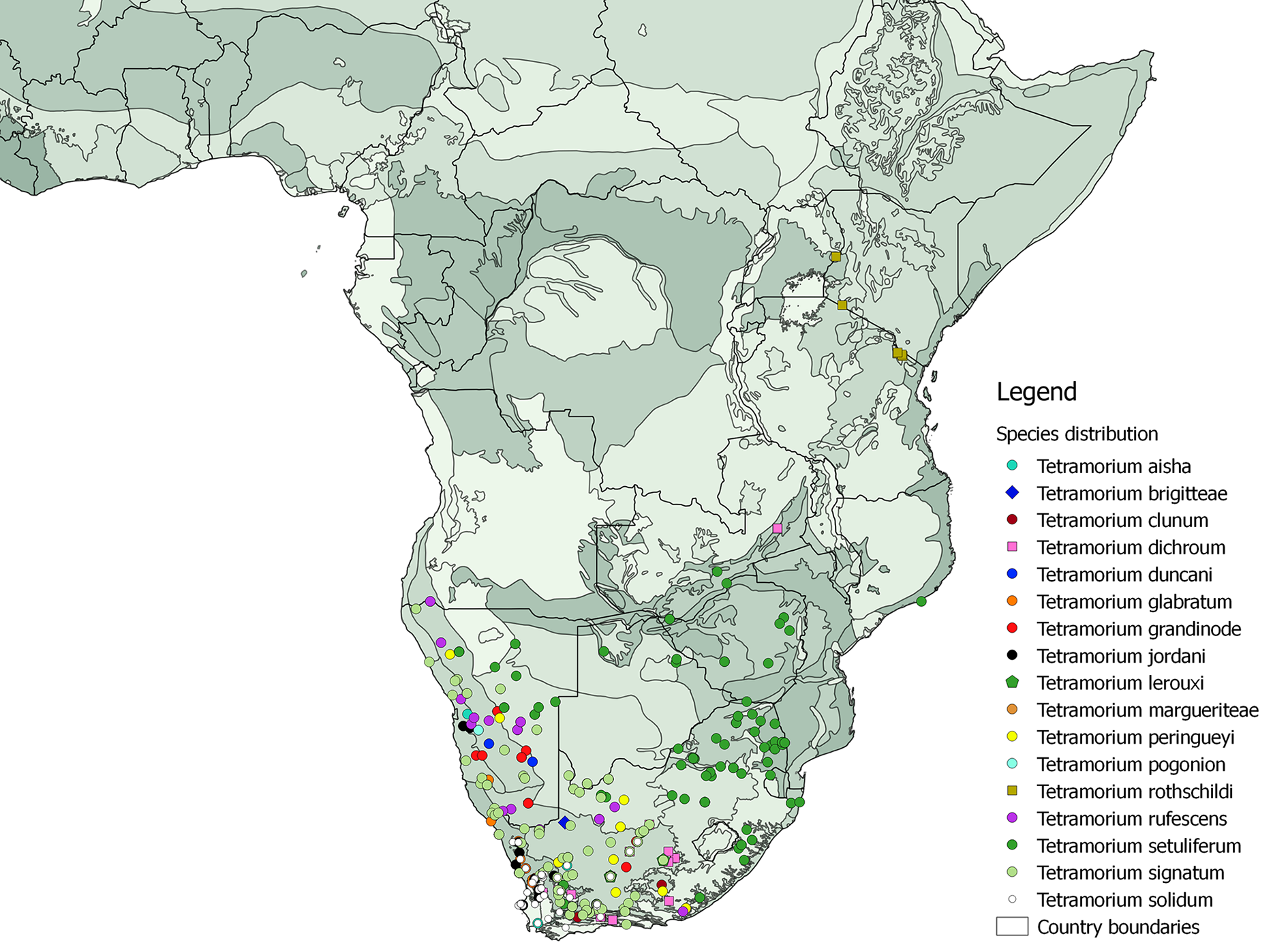
Distribution
Known from South Africa and Namibia.
Remarks
The material examined matched mostly Bolton’s description, but a number of differences were noted. Interestingly, the colour variation in this species is explained by geographical distribution. It looks like there are two forms, the Karoo form and the Kalahari sand form. The specimens collected in the Karoo region mainly in South Africa are brown to black. The specimens collected from red sand dunes (Northern Cape, i.e., Dreghorn and Cullinan Farm, and parts of southern Namibia) are reddish. There is also variation in sculpture pattern. In black coloured specimens, the mesosoma has a strong irregular sculpture on the pronotum and short longitudinal striations on the mesonotum with a punctulate sculpture in between. The nodes have a punctulate sculpture overlain by irregular striations. The first gastral tergite is punctulate or shagreened at the base. Most of the reddish specimens have a strong, irregular sculpture on the pronotum and short longitudinal striations on the mesonotum with a punctulate sculpture in between. In a few specimens, the nodes are predominantly smooth with only reticulate sculpture. The spine length varies in all forms from medium, which are broad at the base, to very short. Based on that high degree of morphological variation, there is a possibility that there is more than one species within both T. signatum and T. rufescens . Nevertheless, this can only be properly addressed within a molecular phylogenetic framework, which is outside the scope of this study. We are hopeful to resolve this question in a future study addressing the evolutionary and biogeographical history of this group. This species has been recorded from South Africa (Eastern Cape, Western Cape and Northern Cape) and Namibia. It has been recorded from the following ecoregions: Albany Thickets, Kalahari Xeric Savanna, Kaokoveld Desert, Knysna-Amatole Montane Forests, Montane Fynbos and Renosterveld, Nama Karoo (including Koedoesberge-Moordenaars Karoo), Namib Desert, Namibian Savanna Woodlands and Succulent Karoo. This species nests in sandy to loamy soils, entrances sometimes with crater of soil around them. Alates were collected from nests in December. Two nests were found with Thysanura inquilines. This species has been collected by digging up nests and also from pitfall traps, yellow pan traps, tuna baits, sugar baits and cookie baits.

| MSNG |
Italy, Genova, Museo Civico di Storia Naturale "Giacomo Doria" |
| BMNH |
United Kingdom, London, The Natural History Museum [formerly British Museum (Natural History)] |
| MHNG |
Switzerland, Geneva, Museum d'Histoire Naturelle |
| SAMC |
South Africa, Cape Town, Iziko Museum of Capetown (formerly South African Museum) |
| CASC |
USA, California, San Francisco, California Academy of Sciences |
| MSNG |
Museo Civico di Storia Naturale di Genova 'Giacomo Doria' |
| MHNG |
Museum d'Histoire Naturelle |
| SAMC |
Iziko Museums of Cape Town |
No known copyright restrictions apply. See Agosti, D., Egloff, W., 2009. Taxonomic information exchange and copyright: the Plazi approach. BMC Research Notes 2009, 2:53 for further explanation.
|
Kingdom |
|
|
Phylum |
|
|
Class |
|
|
Order |
|
|
Family |
|
|
SubFamily |
Myrmicinae |
|
Tribe |
Crematogastrini |
|
Genus |
Tetramorium signatum Emery, 1895
| Mbanyana, Nokuthula, Garcia, Francisco Hita, Robertson, Hamish Gibson & Roux, Johannes Jacobus Le 2018 |
Tetramorium solidum var. tuckeri
| Bolton B. 1980: 251 |
| Arnold G. 1926: 259 |
Tetramorium solidum var. grootensis
| Bolton B. 1980: 251 |
| Forel A. 1913: 118 |
Tetramorium solidum subsp. lugrubre
| Bolton B. 1980: 251 |
| Forel A. 1910: 425 |