
Dolichoderus scabridus Roger
|
publication ID |
https://doi.org/10.11646/zootaxa.3716.2.1 |
|
publication LSID |
lsid:zoobank.org:pub:E76C890A-DC27-4B8A-90CD-41D10682E8FA |
|
DOI |
https://doi.org/10.5281/zenodo.6146856 |
|
persistent identifier |
https://treatment.plazi.org/id/039C0778-2816-FFA4-FF74-F0A7E3498DF1 |
|
treatment provided by |
Plazi |
|
scientific name |
Dolichoderus scabridus Roger |
| status |
|
Dolichoderus scabridus Roger View in CoL
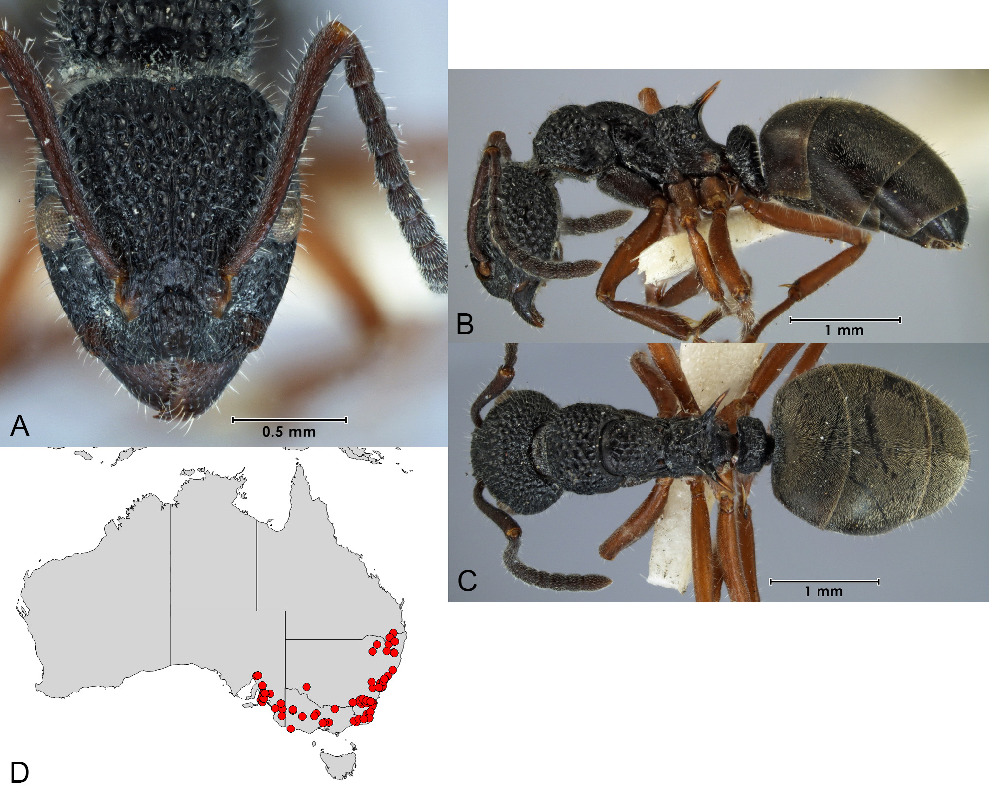
( Fig. 23 View FIGURE 23 )
Dolichoderus scabridus Roger, 1862: 244 .
Polyrhachis foveolatus Lowne, 1865: 334 (junior synonym of scabridus by Mayr 1876:80). Dolichoderus scabridus ruficornis Santschi, 1916: 175 ( new synonym).
Types. Dolichoderus scabridus : "Several" worker syntypes from Australia (specific locality not given) (Roger 1862:244, probably in BMNH). Polyrhachis foveolatus: Unspecified material from Sydney, New South Wales (BMNH). Dolichoderus scabridus ruficornis : 3 worker syntypes from Australia (specific locality not given) (NHMB).
Diagnosis. Pronotum rounded, lacking spines; propodeum with elongate spines directed upward at angle of 45° or less to horizontal plane, the angle between them at least 90°; dorsum of petiolar node broad, base of propodeal spines forming a "U" with a broad concavity connecting their bases (sometimes this region flat or weakly convex); legs yellowish-red in colour, distinctly lighter than the colour of the body.
This species is most similar to D. inferus but differs in having yellowish-red legs. This species is also similar to D. ypsilon , D. rufotibialis and D. niger , but in D. scabridus (and D. inferus ) the petiolar node is broad rather than angular, and the bases of the propodeal spines form a broad "U" rather than a narrowly angled "V" when viewed from the front.
Worker description. See Fig. 23 View FIGURE 23 . All specimens very similar to that figured with the exception of the antennal scape colour, which varies from red to dark reddish-brown.
Measurements (n=5). CI 93–100; EI 19–24; EL 0.26–0.33; HL 1.34–1.47; HW 1.26–1.47; ML 1.89–2.10; MTL 1.10–1.22; PronI 68.58–74.77; PronW 0.91–1.04; SI 95–106; SL 1.30–1.46.
Material examined. Australian Capital Territory: 9 Km East of Mount Gudgenby, Namadgi National Park (Lepschi,B.J.) (ANIC); Black Mountain (Shattuck,S.O.; Taylor,R.W.) (ANIC); Black Mountain, near CSIRO site (Shattuck,S.O.) (ANIC); Black Mt., Site 1 (Barnett,N.J.) (ANIC); Blundells (Greaves,T.) (ANIC); Blundells [Blundells Flat] (Bruce,W.A.; Greaves,T.) (ANIC); Lees Creek (Greaves,T.) (); Lees Spring (Greaves,T.) (ANIC); nr. Picadilly Circus (Taylor,R.W.) (ANIC); Uriarra [Forest] (collector unknown; Greaves,T.; Greaves,T. & F.G.H.) (ANIC); Woods Reserve, nr. Gibraltar Falls (Naumann,I.D.) (ANIC); New South Wales: 2 mi. S of Guyra (Greaves,T.) (ANIC); 23km NW Batemans Bay (Shattuck,S.O.) (ANIC); 2mi. S Guyra (Greaves,T.) (ANIC); 38km SEbyS Mungo (Shattuck,S.O.) (ANIC); 3km SW Morrisset (Gush,T.) (ANIC); 4 mi. S of Deepwater (Greaves,T.) (ANIC); 4.5km N Batemans Bay (Shattuck,S.O.) (ANIC); 4km NE Mt. Wog Wog, 17km SE Bombala (Margules,C.R.) (ANIC); 4km NE Mt. Wog Wog, 17km SE Bombala (Greenslade,P.J.M.) (ANIC); 4mi. S Deepwater (Greaves,T.) (ANIC); 8km SE Ebor (Taylor,R.W.) (ANIC); 9km NE Batemans Bay, West Side Hwy 1, ca. 0.5km N Durras Rd. (Shattuck,S.O.) (ANIC); Acacia Plat. (Armstrong,J.) (ANIC); Acacia Plateau (Armstrong,J.) (ANIC); Bago Forest (Greaves,T.) (ANIC); Bago Forest, Batlow (Greaves,T.) (ANIC); Bago State Forest (Greaves,T.) (ANIC); Bark Hut, Mt. Kaputar Nat. Pk. (Shattuck,S.O.) (ANIC); Batemans Bay (Billen,J.) (ANIC); Bega (Smith) (ANIC); Botany Bay (Schrader,H.P.) (ANIC); Brisbane Water National Park (Gush,T.) (ANIC); Bundeena (Ward,P.S.) (ANIC); Clyde Mountain, Eastern fall (Colless,D.H.) (ANIC); Clyde Mountain, Western fall (Colless,D.H.) (ANIC); Como (collector unknown; Nicholson) (ANIC); Congo, 8km SE by E of Moruya (Upton,M.S.) (ANIC); Cowan (Taylor,R.W.) (ANIC); Dawsons Spring, Mt. Kaputar National Park (Shattuck,S.O.) (ANIC); East Boyd State Forest, Goanna Rd., 56km SE Bombala (Lambkin,C. & Starick,N.) (ANIC); Ebor (Lowery,B.B.) (ANIC); Governor, Mt. Kaputar, Narrabri (Room,P.M.) (ANIC); Gwydir Hwy, 5km E Warialda (Reichel,H.L.M.) (ANIC); Leumeah (Lowery,B.B.) (ANIC); Lidsdale S.F., Lithgow (York,A.) (ANIC); Maroota State Forest (Gush,T.) (ANIC); Menai (collector unknown; Freeland,J.) (ANIC); Mount Ku-ring-gai (Lowery,B.B.) (ANIC); Mumbulla State Forest (Gush,T.) (ANIC); nr. Georges River, Leumeah (Imai,H.T.) (ANIC); Olney State Forest (Gush,T.) (ANIC); Runnyford Ck., Nelligen (collector unknown; Liepa,Z.) (ANIC); South Black Ra., Tallaganda National Park., 14.5km fr. Hoskinstown (Lambkin,C. & Starick,N.) (ANIC); Sydney (Lea) (ANIC); Tantawangalo Mts. (collector unknown; Hill,G.F.) (ANIC); Tomago (Jackson,G.P.) (ANIC); Wang Wauk State Forest (Gush,T.) (ANIC); Whiporie, 55km S Casino (York,A.) (ANIC); Wild Cattle Flat (collector unknown) (ANIC); Woronora (Bason,M.L. & Coutman,J.J.) (ANIC); Queensland: Girraween Nat. Park, Bald Rock Creek Camping Area (Shattuck,S.O.) (ANIC); Girraween NP, nr. The Pyramids (Reichel,H.L.M.) (); South Australia: Alligator Gorge, Flinders Ra. (Greenslade,P.J.M.) (ANIC); Belair (Greenslade,P.J.M.) (ANIC); Belair Nat. Pk. (Greenslade,P.J.M.) (ANIC); Bordertown (McArthur,A.J.) (SAMA); Bridgewater ( Baker,G.F.; Baker,G.H.; Greenslade,P.J.M.) (ANIC); Clare (McAreavey,J.M.) (ANIC); Cleland, Mt. Lofty Ra. (Yeatman,E.) (ANIC); Coorong-Keith, 5km SSW Bunbury (Greenslade,P.J.M.) (ANIC); Cox Scrub National Park (McArthur,A.J.) (SAMA); Gawler, Hale National Park. (Greenslade,P.J.M. & Forrest,J.) (ANIC); Hale National Park. (Greenslade,P.J.M.) (ANIC); Jupiter Creek, 4km W Echunga (Shattuck,S.O.) (ANIC); Kangaroo Creek Reservoir near Athelstone (Lowery,B.B.) (ANIC); Kuitpo (Greenslade,P.J.M.) (ANIC); Long Gully, Belair National Park (McQuillan,P.B.) (SAMA); Mt. Bold Reservoir, SE of Adelaide (Ward,P.S.) (ANIC); Mt. Crawford Forest Reserve (Tuckwell,R.) (SAMA); Mt. Lofty (Greenslade,P.J.M. & Kirkby,C.A.) (ANIC); Mt. Remarkable (Greenslade,P.J.M.) (ANIC); Mt. Remarkable Summit (Greenslade,P.J.M.) (ANIC); Mt. Remarkable, Flinders Ranges (Greenslade,P.J.M.) (ANIC); Myponga (collector unknown; Elston,A.H.) (ANIC); Ngarkat Conservation Park, between Bucks camp well and Box Flat (Mathews,E.G. & Forrest,J.A.) (SAMA); Ngarkat Conservation Park, between north boundary and 12km NW (Forrest,J.A.) (SAMA); Para Wirra Recreation Park (Gross,G.F.) (SAMA); Para Wirra [as Parrawirra] (Greenslade,P.J.M.) (ANIC); Roachdale Reserve, near Williamstown (Szent- Ivány,J.J.H.) (SAMA); S Flinders Ra., Black Hill (Greenslade,P.J.M.) (ANIC); Sevenhill (Lowery,B.B.) (ANIC); Victor Harbour (Greenslade,P.J.M.) (ANIC); Victoria: 50km NNE Orbost nr. Goongerah, Bendoc-Bonang S.F., Bonang Highway (Lambkin,C. & Starick,N.) (ANIC); Bendigo (Froggatt,W.W.; McAreavey,J.) (ANIC); Buchan (collector unknown) (ANIC); Coburg (collector unknown; Spry,F.P.) (ANIC); Coopracambra NP, 26km NNE Cann River (Lambkin,C. & Starick,N.) (ANIC); Greensborough (McAreavey,J.) (ANIC); Kiata (C.H.B.) (ANIC); Maldon (Goudie,J.C.) (ANIC); Portland (Lowery,B.B.) (ANIC); Riddell (collector unknown; Hill,G.F.) (ANIC); Ryans Lookout, Warby Range State Park (Shattuck,S.O.) (ANIC); Salt Lake track, Little Desert National Park (Shattuck,S.O.) (ANIC); Stawell (C.H.B.) (ANIC); Youngs Creek, 12km N Orbost [Young Creek] (Colless,D.H. & Liepa,Z.) (ANIC).
Comments. Dolichoderus ruficornis was established as a subspecies of D. scabridus . Its type specimens differ from typical D. scabridus in having the antennal scapes red rather than dark reddish-brown. No other differences could be found between these two forms during this study and given the minor overall differences in antennal colour both forms are here considered to belong to a single species. It should be noted, however, that the D. ruficornis form predominates at lower elevations in South Australia although it has also been found in Victoria (a single collection from Greensborough) while the D. scabridus form from South Australia is generally found at higher elevation sites in the Flinders Ranges. Across Victoria and New South Wales the D. scabridus form predominates.
Dolichoderus scabridus is one of the most frequently encountered species within the genus, occurring from north-eastern New South Wales south and west to the Adelaide, South Australia region. It is found in a wide range of forested habitats ranging from mallee and spinifex on sand through dry sclerophyll to wet sclerophyll; they have also been found in pine plantations. Workers forage in columns on the ground, on rotten logs and on tree trunks. Nests occur in rotten branches, logs and stumps on the ground, under bark and in soil under rocks.
The following literature has examined this taxon: Clark (1930) (male description), Wheeler and Wheeler (1951) (larval description), Cavill and Hinterberger (1960a) (glandular compounds), Cavill and Hinterberger (1960b) (glandular compounds), Crozier (1970) (karyotype), Wheeler and Wheeler (1974) (larva); Imai, Crozier and Taylor (1977) (karyotype), Blum and Hermann (1978) (venom and venom apparatus) and Freeland et al. (1982) (behaviour, morphology).
No known copyright restrictions apply. See Agosti, D., Egloff, W., 2009. Taxonomic information exchange and copyright: the Plazi approach. BMC Research Notes 2009, 2:53 for further explanation.
|
Kingdom |
|
|
Phylum |
|
|
Class |
|
|
Order |
|
|
Family |
|
|
Genus |