
Aquilegia grubovii Erst et al. (2016: 30)
|
publication ID |
https://doi.org/ 10.11646/phytotaxa.576.2.7 |
|
DOI |
https://doi.org/10.5281/zenodo.7461385 |
|
persistent identifier |
https://treatment.plazi.org/id/039CE85C-FF9E-BD5A-31E5-828EFFF23CAB |
|
treatment provided by |
Plazi |
|
scientific name |
Aquilegia grubovii Erst et al. (2016: 30) |
| status |
|
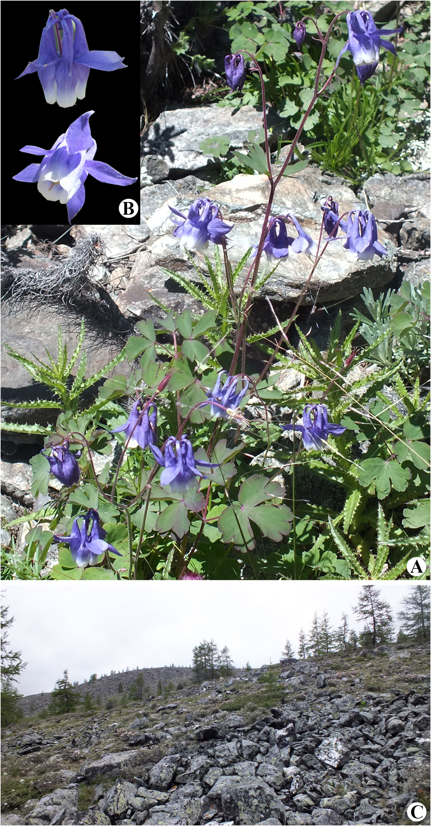
Aquilegia grubovii Erst et al. (2016: 30) View in CoL . Fig. 1A, B View FIGURE 1 .
Type:— MONGOLIA. Eastern Khentii Mountains , upstream of Kerulen and Onon river , bare rocky peaks, NNO to Khentii-Han , western slope, among the boulders, 26 July 1928, N. P. and V. A. Ikonnikov-Galitskiy 546 (holotype and isotype LE!) .
Description:—Perennial herb with short vertical taproot, simple or branched, bearing 3–9 flowering stems. Aerial stems 20–75 cm high, erect, proximally sparsely pubescent with simple hairs, distally glandular-pubescent, at base with dried leaves of the previous year. Basal leaves 5–25 cm long, ternate or 2-ternate, petioles 4–15 cm long, pubescent with short glandular and simple hairs; second order leaflets widely obovate or rounded, 3-lobed or 3-partite; lobes 5–13, rounded or obtuse. Lower cauline leaves 7–18 cm long, ternate or 2–ternate, petioles 4–9 cm long, covered with simple and glandular hairs; nerves of the blades sparsely pubescent with simple and glandular hairs on the lower page; second order leaflets obovate or rounded, 3–5-lobed or separate; lobes 5–15, rounded. Upper cauline leaves 1–6 cm long, ternate or simple, deeply 3-partite, petioles 0.2–1.5 cm long. Bracts 1-ternate to simple, 1–3-fid or partite, with lanceolate or triangular, acute or almost rounded segments; lobes 3–5, rounded or obtuse. Upper cauline leaves and bracts pubescent with short glandular and simple hairs. Flowers 1.5–2.2 cm long, 1.8–3 cm in diameter. Sepals lanceolate or oblong-triangular, acuminate at apex, blue-purple or blue, 0.8–1.5 cm long, sparsely pubescent on the edges. Petals 2-colored, spur blue or purple, 1.5–3 cm long, inflated at the base, cone-shaped, curved or hooked; petal laminae obovate, apex rounded or truncate, white or pale yellow, 1–4 mm shorter than the stamens. Filaments pale cream or white, anthers lemon yellow. Carpels 5–7. Follicles pubescent with short glandular and simple hairs 1–1.5 cm long, styles 4–10 mm long, hooked. Seeds 1.5–2 mm long, surface tuberculate.
Notes: — Aquilegia grubovii could be a stable hybridogenous species. This species is morphologically close to A. oxysepala and A. ganboldii . They have the same characters of sepals (lanceolate with an acute tip) and mixed type of pubescence (simple hairs and glandular trichomes). In addition, A. grubovii is related to A. sibirica Lamarck (1783: 150) and A. amurensis Komarov (1926: 8) especially by its chromatic characteristics of the flower (blue or violet sepals and spurs, white petal laminae).
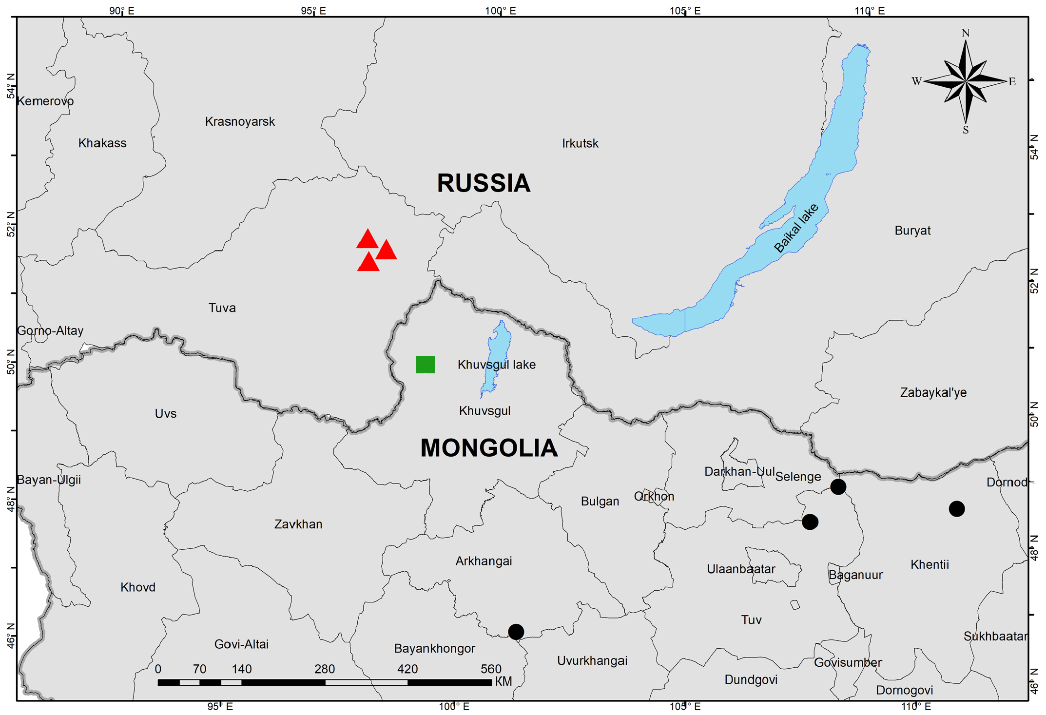
Habitat and distribution: —In Russia (Republic of Tuva), Aquilegia grubovii occurs in habitats similar to those in Mongolia. A stone run (Old Turkic “qorum”) is a rock landform resulting from the erosion of particular rock varieties caused by freezing-thawing cycles in periglacial conditions during the last Ice Age (Mather & Kirtley 1967). Accumulations of stones and the accumulated nutrient soils between them create favorable conditions for the survival of plants. Stones accumulate heat and moisture, and also protect from adverse conditions. The sparseness of woody vegetation and the presence of shrubs give it resistance to frost in winter and fire in dry periods, and the rod-shaped nature of the roots allows it to survive in adverse conditions, when the above-ground parts of the plant are likely to die off. Due to the similarity of environments and climates found in known locations, A. grubovii is expected to be found in other nearby regions in Russia. This species has a natural distribution in the north of Mongolia (Arkhangai, Tuv, and Khentii provinces) and the border regions in Russia (Republic of Tuva) and is endemic to northern Mongolia (Baasanmunkh et al. 2021, 2022) and the border regions of Russia ( Fig. 2 View FIGURE 2 ).
Conservation status: —In Mongolia, only five collections of Aquilegia grubovii are known, from four provinces (Khentii, Tuv, Selenge and Arkhangai), in northern and central Mongolia. The population closest to Russia was recently found in Khuvsgul province. The study of all known populations did not reveal any obvious threats to the existence of the species we found, but the total geographical range of A. grubovii is severely fragmented due to special habitat, representing a barrier to a possibly more continuous distribution range. We estimated an AOO of 24 km ², and EOO of ca. 261,000 km ². Thus, the species is categorized as Vulnerable (VU) due to an AOO of <100 km ², severely fragmented populations (despite the few known locations) with small number of individuals and habitat specificity. Preliminary conservation status of A. grubovii , according to IUCN’s Extent of Occurrence criteria, is categorized as Least Concern (LC) at the global level ( IUCN 2022).
Additional specimens examined:— RUSSIA. Tuva Republic, Todzhinsky Raion, “Azas” Reserve, middle course of the River Azas, 20 km above the mouth of the Myun (right tributary of the Azas River ,aAt the base of the Stone Run ( Bowman Creek ), 52°33´01´´ N, 97°35´03´´ E, alt. 1051 m, 21 July 1996, D. N GoogleMaps . Shaulo & I . Shaulo 62 ( NS) ; Tuva Republic, Todzhinsky Raion, “Azas” Reserve, middle course of the Azas River, 20 km above the mouth of the Myun (right tributary of the Azas River ),at the base of the Stone Run ( Bowman Creek ), 52°33´02´´ N, 97°35´01´´ E, alt. 1070 m. 21 July 1996, D. N GoogleMaps . Shaulo & I . Shaulo 62 ( NS) ; Tuva Republic, Todzhinsky Raion, “Azas” Reserve, middle course of the Azas River, 20 km above the mouth of the Myun (right tributary of the Azas River ), north-east slope of the Stone Run , 52°33´03´´ N, 97°35´07´´ E, alt. 1055 m. 7 July 2002, D. N GoogleMaps . Shaulo 10 ( NS) .
MONGOLIA. Eastern Khentii Mountains, upstream of Kerulen and Onon river , bare rocky peaks, NNO to Khentii-Han, western slope, among the boulders, 26 July 1928, N . P. and V. A. Ikonnikov-Galitskiy 546 ( LE); Arkhangai province, Bulgan Sum , Highland, behind Hoshigot, in forest, 25 July 1977, E . Ganbold 8647 ( UBA); Tuv province, Erdene Sum, Estiin Rashaan, 10 km from Ramaakoas to Ezher, rocks in birch forest, 16 June 1982, Ch. Sanchir et al. ( UBA); Khuvsvul province, Ulaan-Uul sum, Mongorog river , rocky and stony area, 8 July 2019, N . Nyamgerel ( UBU) .
| N |
Nanjing University |
| P |
Museum National d' Histoire Naturelle, Paris (MNHN) - Vascular Plants |
| V |
Royal British Columbia Museum - Herbarium |
| A |
Harvard University - Arnold Arboretum |
| LE |
Servico de Microbiologia e Imunologia |
| I |
"Alexandru Ioan Cuza" University |
| E |
Royal Botanic Garden Edinburgh |
| UBA |
Mongolian Academy of Sciences |
| UBU |
Mongolian State University |
No known copyright restrictions apply. See Agosti, D., Egloff, W., 2009. Taxonomic information exchange and copyright: the Plazi approach. BMC Research Notes 2009, 2:53 for further explanation.
|
Kingdom |
|
|
Phylum |
|
|
Class |
|
|
Order |
|
|
Family |
|
|
Genus |