
Dendrobium camaridiorum Rchb.f.
|
publication ID |
https://doi.org/ 10.5852/ejt.2020.633 |
|
DOI |
https://doi.org/10.5281/zenodo.3803514 |
|
persistent identifier |
https://treatment.plazi.org/id/03A887CA-FF89-FFA4-FDCE-540A6332F99B |
|
treatment provided by |
Valdenar |
|
scientific name |
Dendrobium camaridiorum Rchb.f. |
| status |
|
Dendrobium camaridiorum Rchb.f. View in CoL
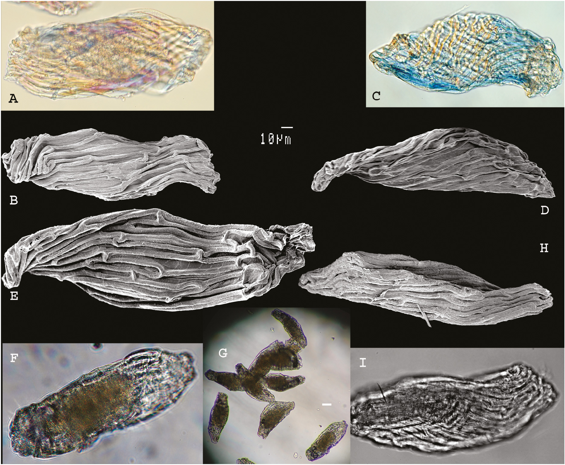
Figs 1E View Fig , M–N, Q–R, 3 View Fig A–B, 4 View Fig Bb, 5 View Fig A–B, 6 View Fig
Linnaea 41: 89 (Reichenbach 1877). – Type: NEW CALEDONIA • Balade; Vieillard 1332 (nec 1192); lectotype: W, here designated; isolectotype: P[ P00124865 ]!.
Material examined
NEW CALEDONIA – Deplanche 528bis; P[ P00124867 , P00124868 ] • Legand 4888; P[ P00124869 ] • s. loc., cultivated in Parc E. Liais, Cherbourg-en-Cotentin ; 5 Apr. 2003; M. Pignal 2046; (original data: collected alive in 1985 in New Caledonia); P[ P00777178 ]. – Province Nord • Haute vallée de la Tchamba ; [21°1′55″ S, 165°13′36″ E]; alt. 100–200 m; gallery forest, near the river; 28 Dec. 1965; H.S. MacKee 13753; P[ P00124850 ] GoogleMaps • Haute vallée de l’Amoa (exploitation forestière Létocart ); [21°0′2″ S, 165°14′31″ E]; alt. 300–500 m; humid forest; 13 Jan.1966; H.S.MacKee 14228; P[ P00124838 , P00124849 ] GoogleMaps • Haute Amoa ; [20°58′24″ S, 165°10′21″ E]; alt. 50–100 m; humid forest; 20 Nov. 1967; H.S. MacKee 17984; P[ P00124846 , P00124874 ] GoogleMaps • Haute Tchamba (exploitation forestière Letocart ); [21°1′11″ S, 165°13′46″ E]; alt. 500 m; humid forest; 21 Nov. 1967; H.S. MacKee 17991; P[ P00124872 ] GoogleMaps • Mont Ignambi (north-east slope); [20°27′11″ S, 164°35′50″ E]; alt. 900 m; humid forest on schists; 8 Nov. 1971; H.S. MacKee 24639; P[ P00124845 ] GoogleMaps • Ponérihouen: east buttress of Mont Aoupinié ; [21°11′0″ S, 165°17′48″ E]; alt. 700–850 m; humid forest on grauwackes; 28 Jun. 1972; H.S. MacKee 25626; P[ P00124844 ] GoogleMaps • Farino, Pic Vincent ; [21°2′48″ S, 165°10′8″ E]; alt. 700 m; humid forest; 3 Mar. 1973; H.S. MacKee 26374; P[ P00124843 ] GoogleMaps • Haute Diahot , Tendé, exploitation forestière Frouin ; [20°24′37″ S, 164°31′19″ E]; alt. 600 m; humid forest, micaschists; 26 Apr. 1976; H.S. MacKee 31162; P[ P00124839 ] GoogleMaps • Roche Ouaième ; [20°38′35″ S, 164°51′36″ E]; alt. 850 m; maquis, schists; 22 Dec. 1977; H.S. MacKee 34465 (leg. Cherrier); P[ P00121154 ] GoogleMaps • Monéo ; [21°8′21″ S, 165°27′51″ E]; alt. 250 m; altered serpentine plateau, maquis; 25 Apr. 1979; H.S. MacKee 36818; P[ P00124877 ] GoogleMaps • Pouébo: Mont Mandjélia ; [20°24′9″ S, 164°31′28″ E]; alt. 700 m; humid forest, micaschists; 8 Feb. 1981; H.S. MacKee 38729 (leg. Bégaud); P[ P00124870 ] GoogleMaps • Mandjélia , forested slopes; [20°24′ S, 164°32′ E]; alt. 500 m; 20 Dec. 1981; G. McPherson 4531; MO GoogleMaps • Ponandou River Valley, forested slopes below Mont Inédète ; 20°49′10″ S, 165°11′18″ E; alt. 550 m; 10 May 2002; G. McPherson 18723; MO GoogleMaps • Cascade la Guen ; 19 Nov. 2010; J. Munzinger 6358, P. Lowry, M. Callmander, H. Vandrot, T. & M. Teimpouene; MO • Bopope, base of the Kantalupaik (south buttress), summit of the Inédète range; 20°51′7″ S, 165°0′28″ E; alt. 320 m; 28 Dec. 2017; fl.; M. Pignal 516 5, J. Munzinger & D. Bruy; P[ P01073021 ] GoogleMaps • Balade ; [20°18′56″ S, 164°29′52″ E]; s.d.; E. Vieillard 1332; P[ P00124865 ] GoogleMaps • Mont Görö Até ; 21°1′42″ S, 165°10′12″ E; 19 Nov. 2002; F. Tronchet 484, J. Munzinger, D. Létocart, I. Létocart, J.-P. Butin, A. Oddi & A. Obry; P[ P00354837 , P00354120 ]. – Province Sud GoogleMaps • Forest of ‘Mois de Mai’ ; [22°7′6″ S, 166°38′48″ E]; 13 Jun. 1951; M.G. Baumann-Bodenheim 14050; P[ P00124861 ] GoogleMaps • ibid.; 24 Jun. 1951; M.G. Baumann-Bodenheim 14179; P[ P00124860 ] GoogleMaps • Mont “Algaoné” [Algaoué], serpentine; [22°12′10″ S, 166°31′40″ E]; alt. 500 m; 19 Dec. 1950; A. Guillaumin 7031 & M.G. Baumann-Bodenheim; P[ P00124859 ] GoogleMaps • Mé Amméri ; [21°39′34″ S, 165°50′36″ E]; alt., 700 m; 27 Nov. 1950; A. Guillaumin 8647 & M.G. Baumann-Bodenheim; P[ P00124852 ] GoogleMaps • ibid.; 27 Nov. 1950; A. Guillaumin 8700 & M.G. Baumann-Bodenheim; P[ P00124851 ] GoogleMaps • ibid.; 28 Nov. 1950; A. Guillaumin 8744 & M.G. Baumann-Bodenheim; P[ P00124854 ] GoogleMaps • ibid.; 28 Nov. 1950; A. Guillaumin 8721; P[ P00124748 ] GoogleMaps • ibid.; 28 Nov. 1950; A. Guillaumin 8780 & M.G. Baumann-Bodenheim; P[ P00124853 ] GoogleMaps • ibid.; 28 Nov. 1950; A. Guillaumin 8882 & M.G. Baumann-Bodenheim; P[ P00124855 ] GoogleMaps • ibid.; 29 Nov. 1950; A. Guillaumin 8938 & M.G. Baumann-Bodenheim; P[ P00124856 ] GoogleMaps • ibid.; 29 Nov. 1950; A. Guillaumin 8969 & M.G. Baumann-Bodenheim; P[ P00124858 ] GoogleMaps • ibid.; 30 Nov.1950; A. Guillaumin 9030 & M.G. Baumann-Bodenheim; P[ P00124864 ] GoogleMaps • Forest of Rivière Bleue ; [22°6′11″ S, 166°38′0″ E]; 22 Feb. 1951; A. Guillaumin 10965 & M.G. Baumann-Bodenheim; P[ P00124857 ] GoogleMaps • ibid.; A. Guillaumin 10966a & M.G. Baumann-Bodenheim; P[ P00124863 ] GoogleMaps • Mont Bario ; [22°10′54″ S, 166°30′18″ E]; alt. 500 m; 20 Apr. 1951; A. Guillaumin & M.G. Baumann-Bodenheim 12523a; P[ P00124862 ] GoogleMaps • Farino: forest of Mépéou (Exploitation forestière Germain); [21°37′5″ S, 165°46′35″ E]; alt. 500 m; humid forest; 11 Feb. 1966; H.S. MacKee 14412; P[ P00124848 , P00124873 ] GoogleMaps • Col d’Amieu: Mont Pembai ; [21°34′36″ S, 165°49′38″ E]; alt. 500–600 m; humid forest; 10 Jun. 1973; H.S. MacKee 26765; P[ P00124842 ] GoogleMaps • ibid.; H.S. MacKee 26766; P[ P00124841 ] GoogleMaps • Port Boisé , associated to 30278; [22°20′58″ S, 166°56′18″ E]; 24 Jan. 1976; H.S. MacKee 30672 (leg. Aymard); P[ P00124840 ] GoogleMaps • 4 km west of Mé Aoui; [21°25′27″ S, 165°32′6″ E]; alt. 600 m; humid forest, schists; 31 Oct. 1976; H.S. MacKee 32173 (leg. Bégaud); P[ P00124847 ] GoogleMaps • Port Boisé ; [22°20′59″ S, 166°56′19″ E]; 9 May 1978; H.S. MacKee 35091 (leg. Bégaud); P[ P00124878 ] GoogleMaps • Paita: Tao ; [20°34′24″ S, 164°47′57″ E]; 8 Apr. 1982; H.S. MacKee 40310 (leg. Bégaud); P[ P00121153 ] GoogleMaps • Piste du Dzumac ; [22°4′46″ S, 166°26′34″ E]; alt. 800 m; 16 Mar. 1985; H.S. MacKee 42497 (leg. Aymard); P [ P00124875 ] GoogleMaps • Dzumac track ; [22°4′2″ S, 166°26′39″ E]; alt. 900 m; humid forest, serpentine terrain; 20 Dec. 1985; H.S. MacKee 42955 (leg. Aymard); P[ P00124871 ] GoogleMaps • Thy River valley , ca 12 air-km NE of Nouméa, rainforest near 400 m; [20°10′55″ S, 166°31′19″ E]; 8 Apr. 1979; G. McPherson 1530; P[ P00124876 ]; MO GoogleMaps • Mt. Rembai: above Col d’Amieu, forested slopes ; [21°36′ S, 165°51′ E]; alt. 650–850 m; 9 May 1984; G. McPherson 6542; P[ P00124876 ]; MO GoogleMaps • Flanc du Mont Dore ; [22°17′36″ S, 166°35′17″ E]; s.d.; Musée Néocalédonien 394; P [ P00124866 ] GoogleMaps .
Description
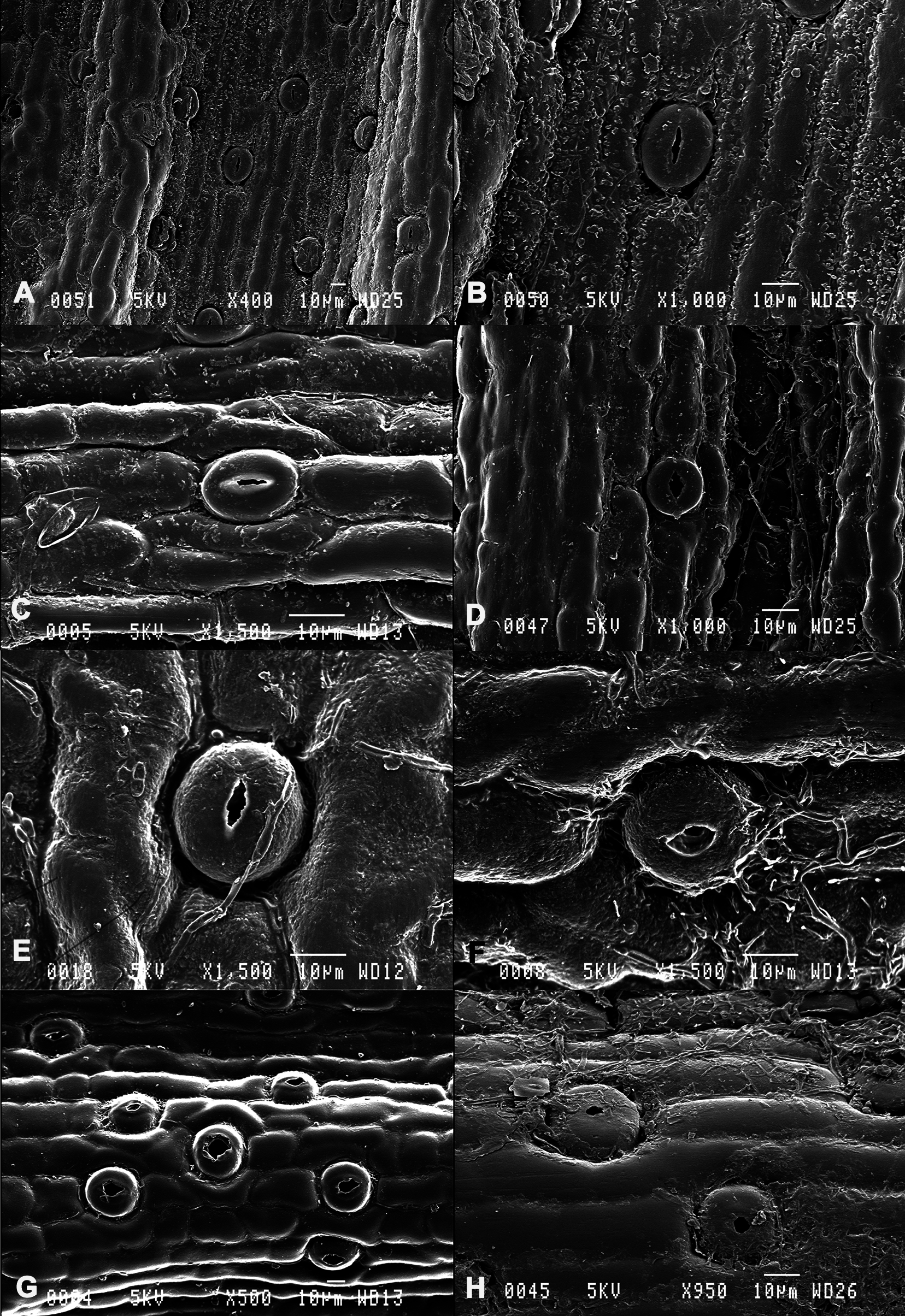
Epiphyte (also lithophytic), erect with graminoid habit. Roots whitish, ca 1–2 mm wide, at the base of the plant (axillary roots lacking, but sometimes with adventive rooted plantlets, ‘keikis’). Stems spindly, 20–70 cm long, cylindrical, covered by the sheaths of the oldest leaves, lamina remaining only from the upper middle to the upper third of the adult stem. Lamina narrow and long, 45–100 × 4–5 mm, apex attenuated, carrying a V-shaped depression under half of its length ( Fig. 1R View Fig ). Internodes 25–30 mm long at the base of the stem. Sheaths deeply furrowed, beak opposite to the lamina, flute-shaped. Inflorescences always 2-flowered. Ovary resupinate. Flower white, fragrant. Sepals long, narrow, attenuated, ca 35 × 2 mm. Petals long and narrow, equaling the sepals, 30 × 2 mm. Lip trilobate, lateral lobes rounded, median lobe ending as a point, the lip with orange deep within. Central carina proximal, without papillose hairs, edge slightly toothed. Dots yellow-orange on the mentum and the carina. Mentum 4 mm long. Column 3 mm long. Fruit fusiform, greenish yellow, ca 15 mm long and 8 mm in diameter. Dried seed with transparent testa about 191 × 54 μm, fusiform, with extremity and base truncate. Extremity strongly spiral. Hydrated seed ovate sacciform. Cells cubic or with extremities rounded, elongate, ca 57–100 × 7.3–8.5 μm, edges thick with spiral orientation, cellular walls smooth. Embryo spherical ca 10–11 μm in diameter ( Fig. 3 View Fig A–B).
Distribution and ecology
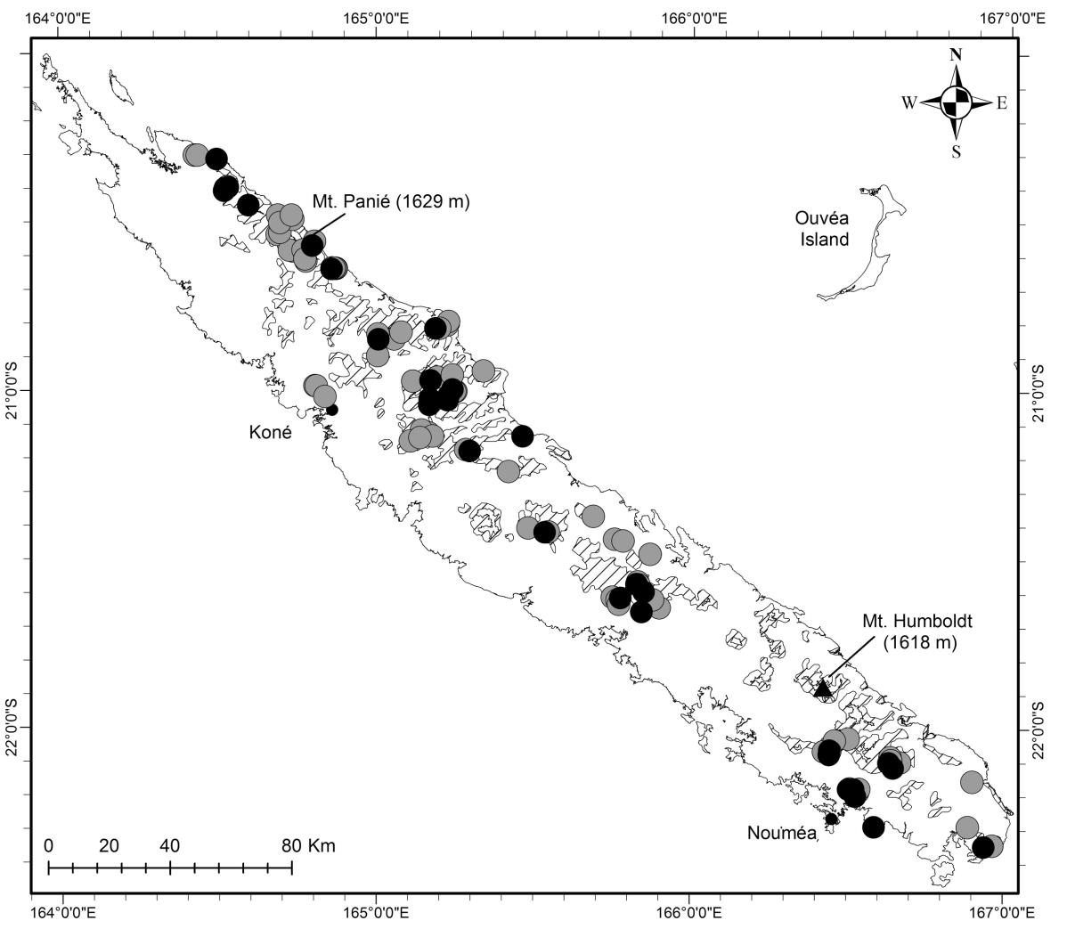
The endemic plant is widespread in humid or gallery forests all over the main island ‘Grande-Terre’, from 50 to 900 m, but has not been observed in sclerophyll forest (west coast), or in the extreme northwest ( Fig. 6 View Fig ).
Taxonomic notes
Dendrobium camaridiorum produces numerous adventive plantlets (‘keikis’), which is not the case of D. butinii sp. nov. The long, attenuated leaves with a V-shaped depression on the blade surface are the easiest characters to observe in D. camaridiorum . It is distinguished from D. butinii sp. nov. by the white, very elongated sepals (shorter and green in D. butinii sp. nov.). Leaf anatomy shows D. camaridiorum very similar to D. letocartiorum sp. nov. (see details under D. letocartiorum sp. nov. below).
Phenology
Flowers are observed throughout the year. It seems that the hours of opening (in the morning) and closing of the flowers (in the afternoon) are synchronous throughout the territory.
IUCN status
Dendrobium camaridiorum is the most abundant species of the graminoid group in New Caledonia, and was evaluated as Least Concern (LC) by the New Caledonian Red List Authority.
Typification
Vieillard’s numeration cannot be understood as true collection numbers ( Morat 2010). Indeed, he often attributed the same number to different gatherings that he regarded as comprising a single species, however he confused many taxa, thereby generating some nomenclatural problems as many of his collections were chosen as types (see for example Pierre et al. 2014). Comparison of the material deposited at W with a specimen at P that clearly represents the same collection indicates that an error occurred in transcribing the number on the former, which is probably a fragment removed from the original specimen. Labels on the Paris specimen bear the number Vieillard 1332, whereas the sheet at W is numbered 1192, which in fact corresponds to material of Phyllanthus cornutus Baill. ( Euphorbiaceae Juss. ). The material in Vienna consists of a stem fragment, several leaves, a single, dissected, immature flower, and a drawing of the Paris material. The latter is a tracing of the Paris plant (Hallé, pers. comm.). This interpretation is consistent with Reichenbach’s visit to P in April 1864 ( Paris Herbarium Visit Catalogue ). Paris’s material comprises a bud and a tuft of 3 stems, and is clearly conspecific with the fragmentary collection at W. We can reasonably assume that Reichenbach studied both P and W material, which would thus represent syntypes. We have selected the material at W as the lectotype as it clearly served as the basis of the description of the flower.


| MO |
Missouri Botanical Garden |
| P |
Museum National d' Histoire Naturelle, Paris (MNHN) - Vascular Plants |
No known copyright restrictions apply. See Agosti, D., Egloff, W., 2009. Taxonomic information exchange and copyright: the Plazi approach. BMC Research Notes 2009, 2:53 for further explanation.
|
Kingdom |
|
|
Phylum |
|
|
Class |
|
|
Order |
|
|
Family |
|
|
Genus |
Dendrobium camaridiorum Rchb.f.
| Pignal, Marc & Munzinger, Jérôme 2020 |
Linnaea
| Linnaea 41: 89 |