
Mycale (Oxymycale) acerata Kirkpatrick, 1907
|
publication ID |
https://doi.org/ 10.11646/zootaxa.4658.3.3 |
|
publication LSID |
lsid:zoobank.org:pub:D926CCEC-56EF-4E9A-98BE-CEB4D4D3D60A |
|
DOI |
https://doi.org/10.5281/zenodo.5584978 |
|
persistent identifier |
https://treatment.plazi.org/id/03B087ED-FFD6-FFB9-FF59-FCF5FBE9D8CB |
|
treatment provided by |
Plazi |
|
scientific name |
Mycale (Oxymycale) acerata Kirkpatrick, 1907 |
| status |
|
Mycale (Oxymycale) acerata Kirkpatrick, 1907 View in CoL
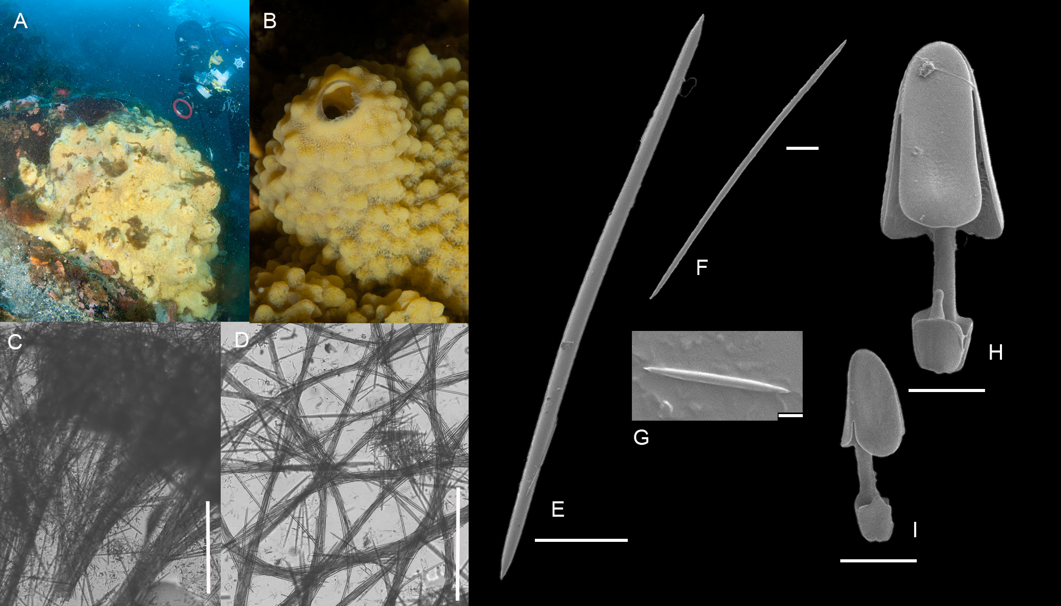
( Figure 18 View FIGURE 18 )
Synonomy: Mycale acerata Kirkpatrick, 1907 ; Mycale acerata var. minor Hentschel, 1914 ; Mycale acerata var. sphaerulosa Hentschel, 1914 ; Oxymycale acerata ( Kirkpatrick, 1907) .
Specimens. BELUM. Mc 2015.552 Gøuvernoren Wreck, Enterprise Island (64°32.407’S, 61° 59.884’W), depth 8–19 m; collected by C. Goodwin and E. Priestley, 12/02/2015 GoogleMaps ; BELUM. Mc 2015.604 Grotto Island , Verdansky Base (Site 1) (65°14.615’S, 64° 15.019’W), depth 14–24 m; collected by C. Goodwin and E. Priestley, 16/02/2015 GoogleMaps ; BELUM. Mc 2015.617 and BELUM. Mc 2015.631 Grotto Island , Verdansky Base (Site 2) (65°14.529’S, 64° 15.451’W), depth 6–18 m; collected by C. Goodwin and E. Priestley, 16/02/2015 GoogleMaps ; BELUM. Mc 2015.649 Rocks near San Martin Islands (65°41.297’S, 65° 20.091’W), depth 6–21 m; collected by C. Goodwin and E. Priestley, 17/02/2015 GoogleMaps ; BELUM. Mc 2015.655 The Minnows, Prospect Point (66°01.642’S, 65° 21.323’W), depth 6–18 m; collected by C. Goodwin and E. Priestley, 17/02/2015 GoogleMaps .; BELUM. Mc 2015.660 Detaille Island (Site 1) (66°52.373’S, 66° 46.967’W), depth 6–24 m; collected by C. Goodwin and E. Priestley, 18/02/2015 GoogleMaps ; BELUM. Mc 2015.690 Rocks NW of Laktionov Island (65°45.536’S, 65° 47.319’W), depth 6–23 m; collected by C. Goodwin and E. Priestley, 22/02/2015 GoogleMaps ; BELUM. Mc 2015.697 and BELUM. Mc 2015.710 Vieugue Island (65°38.758’S, 65° 12.540’W), depth 10–22 m; collected by C. Goodwin and E. Priestley, 23/02/2015 GoogleMaps ; BELUM. Mc 2015.731 Port Charcot, Booth Island (65°03.853’S, 64° 01.868’W), depth 6–16 m; collected by C. Goodwin and E. Priestley, 23/02/2015 GoogleMaps ; BELUM. Mc 2015.780 Under Spiggot Peak, Orne Harbour (64°37.755’S, 62° 33.018’W), depth 5–21 m; collected by C. Goodwin and E. Priestley, 25/02/2015 GoogleMaps ; BELUM. Mc 2015.807 Neptune’s Bellows, Deception Island (62°59.607’S, 60° 33.601’W), depth 7–18 m; collected by C. Goodwin and E. Priestley, 26/02/2015 GoogleMaps ; BELUM. Mc 2015.833 and BELUM. Mc 2015.836 Diomedea Island (62°12.185’S, 58° 56.760’W), depth 10–18 m; collected by C. Goodwin and E. Priestley, 01/03/2015 GoogleMaps .
External morphology. In situ appearance ( Figure 18A View FIGURE 18 ): Lemon yellow, massive, sponge, individuals can be very large - some of our specimens were over 60 cm in diameter. Large specimens are composed of a series of fused mounds, often these bear terminal oscules. The surface of the sponge is covered in small nodules ~ 5 mm in diameter, giving it a bumpy appearance ( Figure 18B View FIGURE 18 ).
Preserved appearance. Grey mass. Skeletal columns visible as distinct fibres ~ 0.5 mm across. Preserving alcohol coloured yellow.
Skeleton: Choanosomal skeleton plumo-reticulate formed of columns of oxea 10–20 spicules thick ( Figure 18C View FIGURE 18 ). Ectosome is composed of a mesh of fibres 4–8 spicules thick ( Figure 18D View FIGURE 18 ). Microscleres are abundant, the larger chelae form rosettes.
Spicules: Measurements from BELUM.Mc2015.780.
Oxeas ( Figure 18E View FIGURE 18 ): 629(679)748 by 16(22) 27 µm with abruptly pointed ends.
Anisochelae 1 ( Figure 18H View FIGURE 18 ): 69(79) 86 µm in rosettes. The lower alae bears a short, antenna-like, projection.
Anisochelae 2 ( Figure 18I View FIGURE 18 ): 33(45) 55 µm. The lower alae bears a single pointed tooth.
Microxeas ( Figure 18F View FIGURE 18 ) 30(84)111 by 1.6(2.1) 2.6 µm. Spindle shaped.
Tiny oxeas/raphides ( Figure 18G View FIGURE 18 ): 6.6(7.1) 7.8 µm.
Remarks. The spicule sizes reported for the type are oxeas 850 by 16 µm, chelae 105 and 47 µm, and trichodragmata 62 µm, although the tiny oxeas are not mentioned—these were not obvious in all of our specimens. Specimens produced a lot of slime on collection. Mycale acerata was very abundant, present at most of our sampling sites, often in large quantities. It is one of the dominant species on the Antarctic Peninsula ( Kowalke 1998).
Mycale acerata is faster growing than many other Antarctic sponges and has been demonstrated to increase 43–67% in terms of wet weight in a year, because of this, it is thought to be able to compete successfully against many slower growing benthic species and may become spatially dominant in some benthic environments ( Dayton et al. 1974). Populations seem to be regulated by predation, particularly that of the asteroids Perknaster fuscus Sladen, 1889 and Acodontaster conspicuus (Koehler, 1920) .
Distribution. Mycale acerata is common along the Antarctic Peninsula, and widespread around the Antarctic and sub-Antarctic (records from Wilheim II Coast, Wilkes Land, South Shetland Islands, Princess Ragnhild Coast, Lars Christensen Coast, Kerguelen, Macquarie Island, Bouvet Island, South Orkneys, South Georgia), as well as being recorded from the Falkland Islands, Chile and Argentina ( Koltun 1964; Brueggeman 1998; Rios et al. 2004; Hajdu et al. 2016). It has been recorded from 10–761 m + depth ( Brueggeman 1998).
| BELUM |
Ulster Museum, Belfast |
No known copyright restrictions apply. See Agosti, D., Egloff, W., 2009. Taxonomic information exchange and copyright: the Plazi approach. BMC Research Notes 2009, 2:53 for further explanation.
|
Kingdom |
|
|
Phylum |
|
|
Class |
|
|
Order |
|
|
Family |
|
|
Genus |
|
|
SubGenus |
Mycale |