
Myxilla (Myxilla) austini, Ott & Reiswig & Harbo, 2019
|
publication ID |
https://doi.org/ 10.11646/zootaxa.4700.1.1 |
|
publication LSID |
lsid:zoobank.org:pub:8EEC6F00-769B-4BF4-B60F-C4AE5D7BB769 |
|
DOI |
https://doi.org/10.5281/zenodo.5584108 |
|
persistent identifier |
https://treatment.plazi.org/id/03BA8781-FF80-FFEB-93F7-64342602F988 |
|
treatment provided by |
Plazi |
|
scientific name |
Myxilla (Myxilla) austini |
| status |
sp. nov. |
Myxilla (Myxilla) austini View in CoL n. sp.
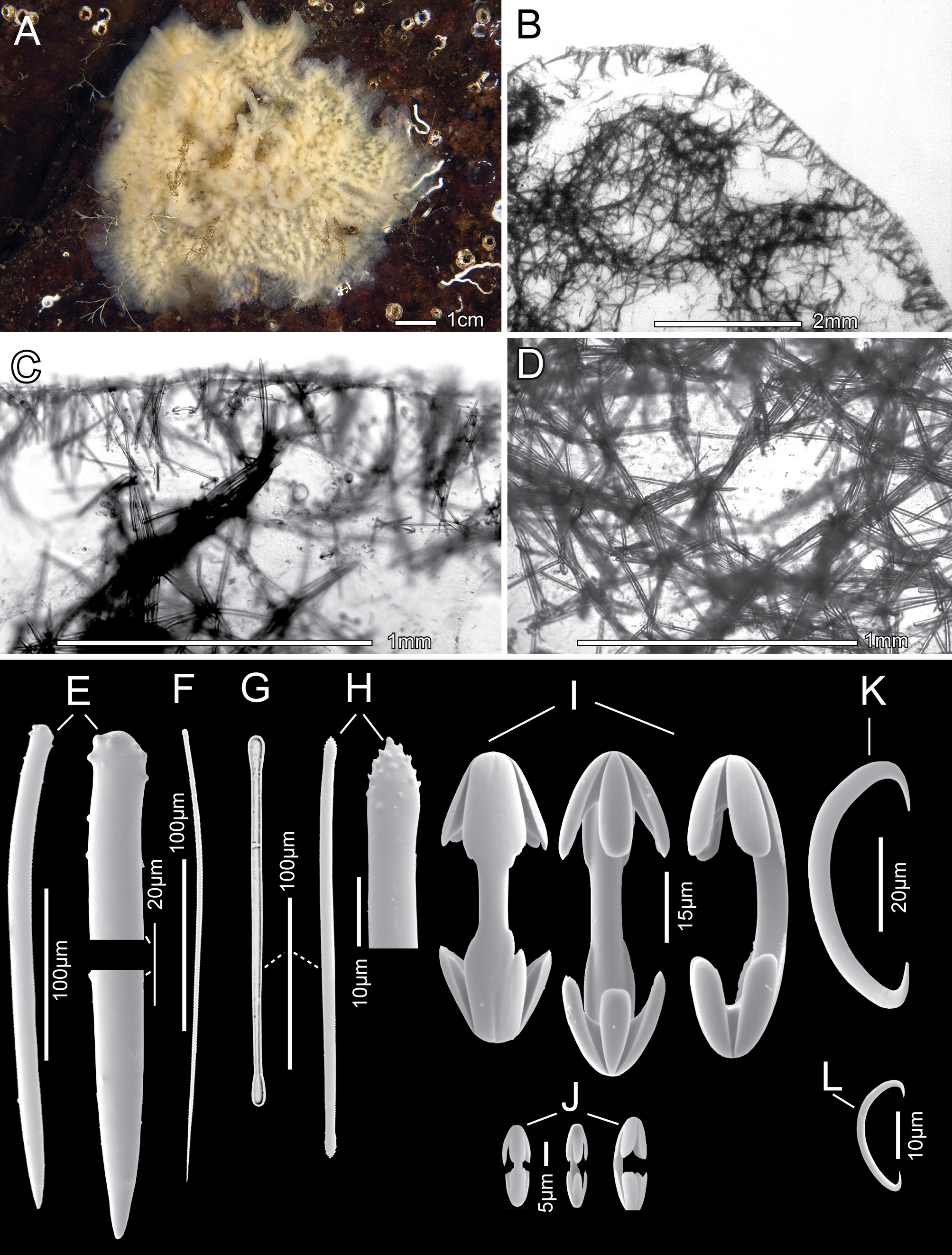
Tables 8 View TABLE 8 and 9 View TABLE 9 , Figure 4 View FIGURE 4
Diagnosis. Sponge surface fistulate, microhispid. Megascleres include fairly common to rare tylotes. Microscleres include uncommon unguiferate isochelae (juvenile forms?)
Etymology. The sponge is named in honour of the late Dr. William C. Austin. Bill was a highly regarded marine biologist, environmentalist and educator who studied and documented marine life of the Pacific Coast of North America for close to 60 years.
Material Examined. Holotype: RBCM Holotype 019-00106-001, Stn. NM 365 , Croker Island , Indian Arm, BC, 49° 25.794’ N / 122° 51.830’ W, coll. N. McDaniel, 25 April 2018, 15 m depth, 1 specimen GoogleMaps .
Paratype: RBCM Paratype 019-00107-001, Stn. NM 273 , Croker Island , Indian Arm, BC, 49° 25.747’ N / 122° 51.874’ W, coll. N. McDaniel, 7 February 2012, 20 m depth, 1 specimen GoogleMaps .
Other Material Examined: (all deposited at RBCM) RBCM 019-00108-001, Stn. NM 344 , Croker Island , Indian Arm , BC, 49° 25.792’ N / 122° 51.889’ W, coll. N. McDaniel, 14 Sep 2016, depth 15 m, 1 specimen GoogleMaps . RBCM 019-00108 View Materials - 002 View Materials , Stn . NM 345 , Croker Is., Indian Arm , BC, 49°25.792’N / 122°51.889’ W W, coll. N. McDaniel, 14 Sep 2016, 15 m depth, 1 specimen GoogleMaps . RBCM 019-00110 View Materials - 001 View Materials , Stn . NM 347 , Sakinaw Rock, Sechelt , BC, 49° 34.039’ N / 123° 48.178’ W, coll. N. McDaniel, 18 Sep 2016, 25 m depth, 1 specimen GoogleMaps . RBCM 019-00111 View Materials - 001 View Materials , Stn . NM 379 , Croker Is., Indian Arm , BC, 49°25.788’ N / 122°51.775’ W W, coll. N. McDaniel, 27 Aug 2018, depth 15 m, 1 specimen GoogleMaps . RBCM 019-00111 View Materials - 002 View Materials , Stn . NM 380 , Croker Is., Indian Arm , BC, 49°25.788’ N / 122°51.775’ W, coll. N. McDaniel 27 Aug 2018, depth 15 m, 1 specimen GoogleMaps . RBCM 019-00111 View Materials - 003 View Materials , Stn . NM 381 , Croker Is., Indian Arm , BC, 49°25.788’ N / 122°51.775’ W, coll. N. McDaniel, 27 Aug 2018, depth 15 m, 1 specimen GoogleMaps . RBCM 019-00112 View Materials - 001 View Materials , Stn . NM 383 , Ayers Point, Hood Canal , WA, 47° 22.664’ N / 123° 6.828’ W, coll. G. Jensen, 6 Jan 2018, depth 15 m, 1 specimen GoogleMaps .
| RBCM |
Royal British Columbia Museum |
No known copyright restrictions apply. See Agosti, D., Egloff, W., 2009. Taxonomic information exchange and copyright: the Plazi approach. BMC Research Notes 2009, 2:53 for further explanation.
|
Kingdom |
|
|
Phylum |
|
|
Class |
|
|
Order |
|
|
Family |
|
|
Genus |