
Fluminicola ahjumawi, Hershler & Liu & Frest & Johannes, 2007
|
publication ID |
https://doi.org/ 10.1111/j.1096-3642.2007.00243.x |
|
DOI |
https://doi.org/10.5281/zenodo.5488424 |
|
persistent identifier |
https://treatment.plazi.org/id/03BC4773-0B4A-F733-40E9-F9431A85FB15 |
|
treatment provided by |
Felipe |
|
scientific name |
Fluminicola ahjumawi |
| status |
sp. nov. |
FLUMINICOLA AHJUMAWI SP. NOV. (AHJUMAWI
PEBBLESNAIL)
Type material: Holotype ( Fig. 16A View Figure 16 ), USNM 1020691 View Materials , spring run north of Sam Wolfin Spring, south of Pit River and powerlines, 1.93 km south-west of Pit 1 Powerhouse , Pacific Gas and Electric land, Shasta County, California (625140 E, 4537060 N, 860 m), 31 August 2001 TF, EJ . Paratypes, USNM 1020699 View Materials , from same lot .
Referred material: CALIFORNIA. Modoc County: USNM 1020703 View Materials , Jimmerson Spring on south side of Modoc County 93, 3.38 km north-west of Jimmerson Mountain (642800E, 4567230 N, 1318 m), 19 July 2002 TF, EJ . Shasta County: USNM 1020692 View Materials , spring on west side of run of Thousand Spring, 0.32 km south-west of source of Thousand Springs, south of Mares Meadow , Thousand Springs Ranch (621560 E, 4552530 N, 1011 m), 1 September 2001 TF, EJ. – USNM 1020693 View Materials , Hat Creek at Bridge Picnic Area across from Bridge Campground , Lassen National Forest (632000 E, 4510000 N, 1262 m), 29 August 2001 TF, EJ. – USNM 1020694 View Materials , three unnamed springs on point opposite large island in Pit River (north-east side), c. 0.31 km north-west of CA 299 bridge across Pit River (621680 E, 4537580 N, 841 m), 12 September 1993 TF, EJ. – USNM 1020695 View Materials , ibid., 3 August 2001 TF, EJ. – USNM 1020696 View Materials , lower part of unnamed spring run, north-east side of Lions Club Picnic Grounds, near access road and just above (west of) Pit River, near Pit River Hatchery (625090 E, 4538340 N, 869 m), 31 August 2001 TF, EJ. – USNM 1020697 View Materials , ibid., 16 August 2000, TF, EJ. – USNM 1020698 View Materials , Honn Creek at Honn Creek Campground, just east of CA 89 , c. 2.9 km south of Hat Creek Forest Service Station, Lassen National Forest (626450 E, 4515120 N, 1034 m), 29 August 2001 TF, EJ. – USNM 1020700 View Materials , west spring source of Mallard Creek, west of source of Thousand Springs, Thousand Springs Ranch (621120 E, 4552740 N, 1011 m), 1 September 2001 TF, EJ. – USNM 1020701 View Materials , Beaver Creek just over 0.16 km downstream (west of) Beaver Spring, 0.16 km upstream of FS34N10 crossing, Lassen National Forest (649540 E, 4520640 N, 479 m), 24 September 2001 TF, EJ. – USNM 1020702 View Materials , Burney Creek at Falls Trail bridge, c. 0.08 km upstream of Burney Falls , McArthur–Burney Falls Memorial State Park (613420 E, 4540640 N, 881 m), 25 September 2001 TF, EJ. – USNM 1020704 View Materials , Lost Creek (upper site) in lava field on north side of Wilcox Road, west of Hat Creek Rim , Lassen National Forest (632560 E, 4513140 N, 1141 m), 29 August 2001 TF, EJ. – USNM 1020797 View Materials , Lost Creek above intake for upper penstock (of two), c. 0.32 km above mouth of canyon, Hat Creek Rim, Lassen National Forest (634450 E, 4513060 N, 1241 m), 3 November 2002 TF, EJ. – USNM 1020798 View Materials , Lost Creek (upper most site) in lava field on north side of Wilcox Road, west of Hat Creek Rim , inside and west of Lassen National Forest boundary (632730 E, 4513100 N, 1141 m), 3 November 2002 TF, EJ. – USNM 1020791 View Materials , upper end of Sucker Springs Creek channel, north-east of California Fish and Game Pit River Hatchery on west side of access road and Pit River , 0.97 km southwest of Pit 1 Powerhouse (Pacific Gas and Electric) (625320 E, 4538180 N, 875 m), 31 August 2001 TF, EJ .
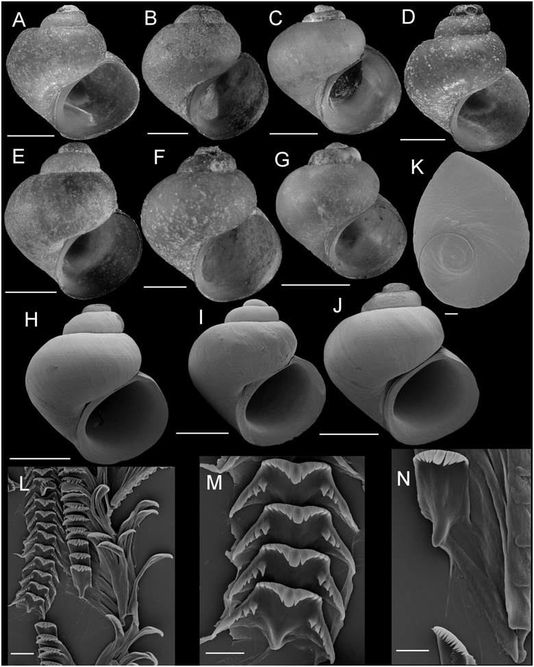
Diagnosis: Readily differentiated from geographically proximal and occasionally syntopic F. seminalis by its smaller size, broader shell, more convex and narrowly shouldered teleoconch whorls, broader columellar lip, weaker collabral growth lines, and thinner, lighter coloured periostracum. Differs from other congeners of the Pit River basin by the combination of fairly large size, globose or broadly conical shell, ovate or weakly angled aperture, absent or very narrow umbilicus, and well-developed columellar lip.
Description: Shell ( Fig. 16A–J View Figure 16 ; Table 10) usually subglobose to trochoidal, rarely ovate-conic, usually having eroded spire; height, 2.42–4.53 mm; whorls, 3.25– 3.75. Protoconch 1.4 whorls, diameter approximately 0.70 mm. Teleoconch whorls medium to high convexity, often having broad, prominent shoulders, rarely having subsutural thickening or weak cord. Aperture ovate or weakly angled adapically, sometimes having subsutural angulation. Parietal lip complete, adnate, sometimes thickened across parietal wall and forming fairly broad callus. Columellar lip medium width, often covering umbilical region. Outer lip usually thin, rarely thickened, prosocline, sometimes weakly sinuate. Shell usually anomphalous, sometimes having rimate umbilicus; umbilical region sometimes weakly excavated. Periostracum tan or brown. Last 0.5 whorl of operculum weakly frilled ( Fig. 16K View Figure 16 ). Central radular tooth approximately 37 µm wide, cutting edge almost horizontal (very slightly indented), lateral cusps three to six; central cusp parallel-sided, rounded; basal cusps two to four; basal tongue Vshaped, even with lateral margin ( Fig. 16M View Figure 16 ). Lateral tooth face rectangular; central cusp rounded; lateral cusps four to five (inner), four to five (outer); outer wing flexed, elongate ( Fig. 16N View Figure 16 ). Inner marginal teeth having 24–32 cusps ( Fig. 16L View Figure 16 ). Outer marginal teeth having 25–37 cusps; basal wing narrowly rectangular or absent ( Fig. 16L View Figure 16 ). Head-foot dark brown or black. Ctenidium abutting pericardium; ctenidial filaments 18, broadly triangular, lacking pleats. Osphradium elongate, positioned opposite centre of ctenidium. Bursa copulatrix as long as wide, pyriform; duct short. Seminal receptacle medium-sized, completely overlapped by albumen gland. Rectal furrow well developed on albumen gland. Capsule gland a little longer than albumen gland. Genital aperture a simple pore. Penis medium-sized, thick, distal end tapering or pointed ( Fig. 7H View Figure 7 ). Penis having black internal pigment concentrated in distal two-thirds of length; brown melanin cover often present on base. Penial duct near centrally positioned, weakly undulating medially.
Distribution: Broadly ranging within the lower Pit River basin, including drainages of Hat Creek, Lost Creek, and Fall River. Also found at one locality in the upper Pit River basin (Jimmerson Spring).
Etymology: Referring to the Native American tribe (also known as the Achumawi) that lived in the vicinity of the Fall and Pit Rivers.
Remarks: In the phylogenetic trees, this species often occupied a near basal position within clade A. On the basis of sequence divergence, F. ahjumawi is most similar to F. lunsfordensis ( COI 1.9–2.7%) and Fluminicola sp. (B) (cytb 1.4–2.5%).
This species was referred to as F. turbiniformis by Frest & Johannes (1993) and as Fluminicola n. sp. 10 by Frest & Johannes (1995a).

| TF |
Department of Mineral Resources |
| EJ |
Ein Yabrud collection catalogue entries at The Hebrew University |
| COI |
University of Coimbra Botany Department |
No known copyright restrictions apply. See Agosti, D., Egloff, W., 2009. Taxonomic information exchange and copyright: the Plazi approach. BMC Research Notes 2009, 2:53 for further explanation.
|
Kingdom |
|
|
Phylum |
|
|
Class |
|
|
Order |
|
|
Family |
|
|
Genus |