
Fluminicola multifarius, Hershler & Liu & Frest & Johannes, 2007
|
publication ID |
https://doi.org/ 10.1111/j.1096-3642.2007.00243.x |
|
DOI |
https://doi.org/10.5281/zenodo.10544949 |
|
persistent identifier |
https://treatment.plazi.org/id/03BC4773-0B79-F722-4364-FCEA1D60FC5C |
|
treatment provided by |
Felipe |
|
scientific name |
Fluminicola multifarius |
| status |
sp. nov. |
FLUMINICOLA MULTIFARIUS SP. NOV. (SHASTA
PEBBLESNAIL)
Type material: Holotype ( Fig. 24A View Figure 24 ), USNM 883782 View Materials , Big Springs (source) at Big Springs City Park northwest of the city of Mount Shasta , south of Spring Hill , Siskiyou County, California (556400 E, 4575265 N, 1092 m), 25 May 1991 TF, EJ . Paratypes (from same lot), USNM 1020753 View Materials .
Referred material: CALIFORNIA. Siskiyou County: USNM 1020754 View Materials , topotypes, 12 October 1992 TF, EJ. – USNM 1020755 View Materials , topotypes, 23 August 2001 TF, EJ. – USNM 1020756 View Materials , Ney Springs on the north side of Ney Springs Road, north tributary of Ney Springs Creek , east of Faery Falls , south-west of the city of Mount Shasta (556120 E, 4568040 N, 964 m), 12 October 1992 TF, EJ. – USNM 1020757 View Materials , ibid., 23 August 2001 TF, EJ. – USNM 1020758 View Materials , Sacramento River on the north side, just upstream and opposite from the mouth of Stink Creek , at former site of USGS gauging station, just west (upstream) of the site of Cantara (Cantara Bend), near the end of Cantara Road , Cantara / Ney Springs Wildlife Area (California Fish and Game) (557860 E, 4568220 N, 915 m), 13 October 1992 TF, EJ. – USNM 1020759 View Materials , ibid., 21 September 1996 TF, EJ. – USNM 1020760 View Materials , ibid., 17 August 2000 TF, EJ. – USNM 1020761 View Materials , unnamed spring above north side of Sacramento River , ditched on north side of UPRR track, tributary (west side) to first permanent creek west of Big Canyon Creek, east of Cantara Bend ( Cantara town site) (559160 E, 4568405 N, 885 m), 6 September 1993 TF, EJ. – USNM 1020762 View Materials , ibid., 1 October 2001 TF, EJ. – USNM 1020763 View Materials , unnamed spring above sharp bend in Sacramento River (north side), collected on north side of UPRR track, east of Cantara Bend ( Cantara town site) (558820 E, 4568560 N, 878 m), 6 September 1993 TF, EJ. – USNM 1020764 View Materials , ibid., 1 October 2001 TF, EJ. – USNM 1020765 View Materials , Big Springs three middle runs upstream of wooden bridges of access trail, c. 31 m west of eastern-most spring run, Big Springs City Park north-west of the city of Mount Shasta, south of Spring Hill (556370 E, 4575265 N, 1092 m), 23 August 2001 TF, EJ. – USNM 1020766 View Materials , Big Springs westernmost run upstream of wooden bridge of access trail, c. 61 m west of eastern-most spring run and 31 m west of three middle spring runs, south of Spring Hill on west edge of Big Springs City Park north-west of the city of Mount Shasta (556330 E, 4575280 N, 1092 m), 23 September 1996 TF, EJ, JL. – USNM 1020767 View Materials , ibid., TF, EJ, JL. – USNM 1020768 View Materials , Big Springs east spring run downstream of wooden bridge of access trail, c. 31 m south of source springs, Big Springs City Park northwest of the city of Mount Shasta, south of Spring Hill (556390 E, 4575240 N, 1092 m), 23 August 2001 TF, EJ. – USNM 1020769 View Materials , west spring run of Big Springs on west side of Big Springs City Park, collected approximately 61 m below spring sources, north-west of the city of Mount Shasta , south of Spring Hill (556350 E, 4575220 N, 1089 m), 23 August 2001 TF, EJ. – USNM 1020771 View Materials , Bundoora Spring c. 0.16 km west of Tom Cabin Spring and ruins of Tom’s Cabin , west of access road off FS40N44 c. 0.48 km west of Camp 4, Shasta National Forest (584400 E, 4564900 N, 1083 m), 30 September 2001 TF, EJ. – USNM 1020801 View Materials , Lower Elk Spring , at spring house (577223 E, 4572303 N, 1179 m), 4 November 2004 AH. – USNM 1020802 View Materials , ibid., 21 December 2004 JC. – USNM 1020803 View Materials , Elk Spring , outflow channel (577316 E, 4572190 N, 1172 m), 21 December 2004 JC. – USNM 1020772 View Materials , spring flowing under UPRR tracks (source on west side of tracks), collected on both sides of tracks, west of Sacramento River, opposite mouth of Sweetbrier Creek , near the former site of Conant (556720 E, 4551100 N, 561 m), 25 August 2001 TF, EJ. – USNM 1020773 View Materials , Crystal Spring near its source (which is now a covered well) on west-facing slope above the Sacramento River, above bridge of Zig Zag Trail , Shasta Springs, St. Germain Foundation (561580 E, 4566360 N, 854 m), 17 October 1992 TF, EJ. – USNM 1020774 View Materials , ibid., 25 August 2001 TF, EJ. – USNM 1020775 View Materials , 1020776 View Materials , Rock Spring above (east of) UPRR tracks, above Sacramento River (east side), Shasta Springs (561580 E, 4566200 N, 769 m), 17 October 1992 TF, EJ. – USNM 1020777 View Materials , 1020778 View Materials , ibid., 24 August 2001 TF, EJ. – USNM 1020779 View Materials , fourth spring from the north at the lower (downstream) end of Shasta Springs complex, east side of the Sacramento River above UPRR track (561560 E, 4566000 N, 756 m), 21 October 1992 TF, EJ. – USNM 1020780 View Materials , 1020781 View Materials , 1020782 View Materials , 1020792 View Materials , ibid., 24 August 2001 TF, EJ. – USNM 1020800 View Materials , springs north of Mossbrae Falls on a west-facing slope, east side of the Sacramento River above UPRR track near the north end of railroad bridge (561520 E, 4565800 N, 756 m), 21 October 1992 TF, EJ. – USNM 1020783 View Materials , ibid., 24 August 2001 TF, EJ. – USNM 1020784 View Materials , spring runs north of Mossbrae Falls on a west-facing slope, east side of the Sacramento River , near the east side of UPRR bridge (561560 E, 4565720 N, 769 m), 21 October 1992 TF, EJ. – USNM 1020785 View Materials , ibid., 24 August 2001 TF, EJ. – USNM 1020786 View Materials , east side of the Sacramento River at Cave Springs below Cave Springs Resort and Motel , Dunsmuir ; 30 m transect north (upriver) from Cave Springs run (560710 E, 4564080 N, 724 m), 24 August 2001 TF, EJ. – USNM 1020787 View Materials , ibid., 14 October 2003 TF, EJ. – USNM 1020788 View Materials , spring run north of Crystal Spring ( Glacier Spring ) run, north side of northern most switch back of Zig Zag Trail, Shasta Springs, Saint Germain Foundation (561520 E, 4566310 N), 25 August 2001 TF, EJ .
Diagnosis: Readily distinguished from F. scopulinus , which also lives in the Sacramento River headwaters, by its smaller shell umbilicus and broader columellar lip. Distinguished from F. seminalis , which also lives in the McCloud River drainage, by its smaller size, more convex shell whorls, well-developed shell parietal lip, more numerous radular tooth cusps, and squatter penis.
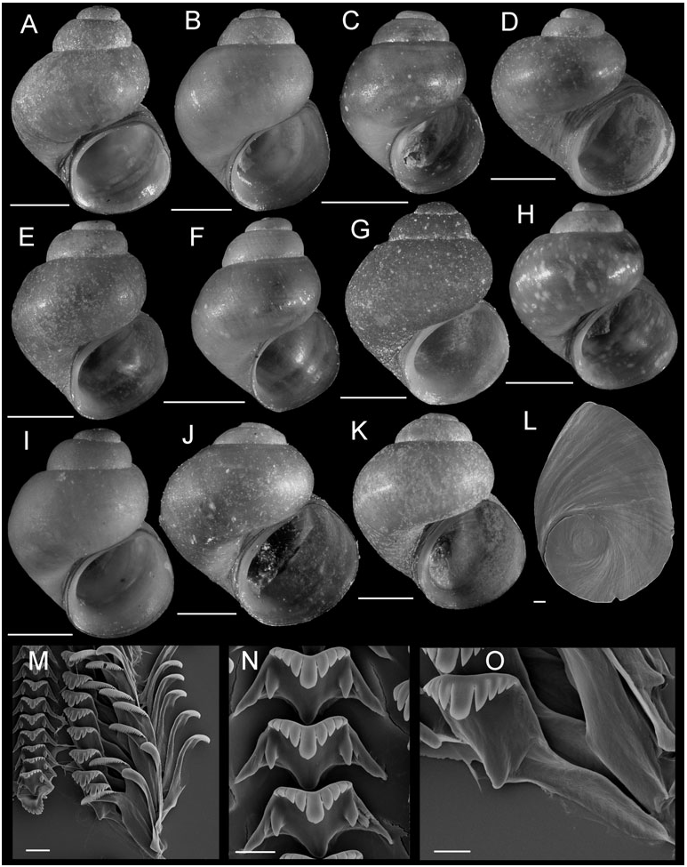
Description: Shell ( Figs 24 View Figure 24 , 25A–K View Figure 25 ; Table 15) usually subglobose to narrow conical; height, 2.30–4.64 mm; whorls, 3.25–4.50. Protoconch 1.4 whorls, diameter approximately 0.82 mm; spiral microsculpture often wavy or wrinkled near apex. Teleoconch whorls weakly to highly convex, often having weak subsutural angulation; shoulders usually absent or narrow, rarely broad. In some conical shelled populations, specimens had last 1.0 whorl loosened from body whorl, producing an almost scalariform appearance ( Figs 24P View Figure 24 , 25D View Figure 25 ). Aperture broadly ovate, often angled above. Parietal lip complete, thin or slightly thickened, usually adnate, sometimes slightly disjunct, lip usually forming callus. Columellar lip medium width, often covering all or most of umbilical region. Outer lip thin or slightly thickened, sometimes markedly so, prosocline, weakly sinuate. Shell usually anomphalous, sometimes narrowly rimate, rarely perforate. Periostracum tan, brown, or light green. Last 0.5 operculum whorl frilled ( Fig. 25L View Figure 25 ). Central radular tooth approximately 41 µm wide, cutting edge convex, lateral cusps three to four; central cusp parallel-sided, rounded or weakly pointed; basal cusps one to two, basal tongue V- or U-shaped, even with lateral margin ( Fig. 25N View Figure 25 ). Lateral tooth face broadly rectangular; central cusp rounded, lateral cusps three (inner), three to four (outer); outer wing flexed, medium length ( Fig. 25O View Figure 25 ). Inner marginal teeth having 22–29 cusps ( Fig. 25M View Figure 25 ). Outer marginal teeth having 23–33 cusps; basal wing rectangular ( Fig. 25M View Figure 25 ). Head-foot dark brown, almost black. Ctenidium connected to pericardium by short, efferent branchial vessel; ctenidial filaments approximately 17, without pleats. Osphradium elongate, positioned opposite middle of ctenidium. Bursa copulatrix horizontal; ovate, pyriform or triangular; duct medium length. Seminal receptacle small or medium-sized, sometimes only partly overlapped by albumen gland. Glandular oviduct having well-developed rectal furrow. Capsule gland about as long as albumen gland. Genital aperture a simple pore or weak papilla. Penis mediumsized, fairly broad, tightly coiled, distal end pointed or papillate ( Fig. 7M View Figure 7 ). Penis having dark brown or black patch of internal pigment concentrated distally, surface pigment very light. Penial duct positioned near outer edge, straight except for a few distal undulations.
Distribution: Sacramento River headwater region (as far downflow as Conant), and a few sites in the upper reaches of the McCloud River drainage ( Fig. 20 View Figure 20 ).
Etymology: From New Latin multifarius , meaning in many places, or in various manners, and referring to the broad range of shell shape observed in this species.
Remarks: As noted in the Results section, this species is composed of two distinct subclades that differ by 2.1–3.0% ( COI) and 3.3–4.7% (cytb) and are allopatrically distributed, with one ranging from Shasta Springs to Conant along the Sacramento River and the other distributed in the Sacramento headwater region from Cantara Bend to Big Springs (north of the city of Mount Shasta) as well as in the upper McCloud River drainage. Marked shell variation, with shape ranging from subglobose to narrowly conic and the entire body whorl sometimes completely loosened from the coiling axis, was observed within both subclades and sometimes within individual populations. Distinct shell morphs (e.g. at site 65) collected in sympatry did not differ in sequences of either gene and also did not differ anatomically. On the basis of these observations and the morphological overlap described above, we chose to treat the two subclades as a single species at this time, although the evolutionary and taxonomic significance of the remarkable shell variation within this taxon merits additional study. F. multifarius was variably positioned relative to other species of clade C described herein in the phylogenetic analyses and differs from these by 2.6–4.6% ( COI) and 6.4–10.3% (cytb).
Populations of this species were referred to as Fluminicola n. sp. 1, Fluminicola n. sp. 3, Fluminicola n. sp. 4, and Fluminicola n. sp. 5 by Frest & Johannes (1993).


No known copyright restrictions apply. See Agosti, D., Egloff, W., 2009. Taxonomic information exchange and copyright: the Plazi approach. BMC Research Notes 2009, 2:53 for further explanation.
|
Kingdom |
|
|
Phylum |
|
|
Class |
|
|
Order |
|
|
Family |
|
|
Genus |