
Camponotus grandidieri Forel
|
publication ID |
https://doi.org/10.11646/zootaxa.4238.2.2 |
|
publication LSID |
lsid:zoobank.org:pub:1030F6ED-734A-44C1-9D9C-BC94BCB7A6CD |
|
DOI |
https://doi.org/10.5281/zenodo.3512206 |
|
persistent identifier |
https://treatment.plazi.org/id/03BD9D5B-FFC1-FFA4-FF43-FA51FF73FEAD |
|
treatment provided by |
Plazi |
|
scientific name |
Camponotus grandidieri Forel |
| status |
|
Camponotus grandidieri Forel View in CoL
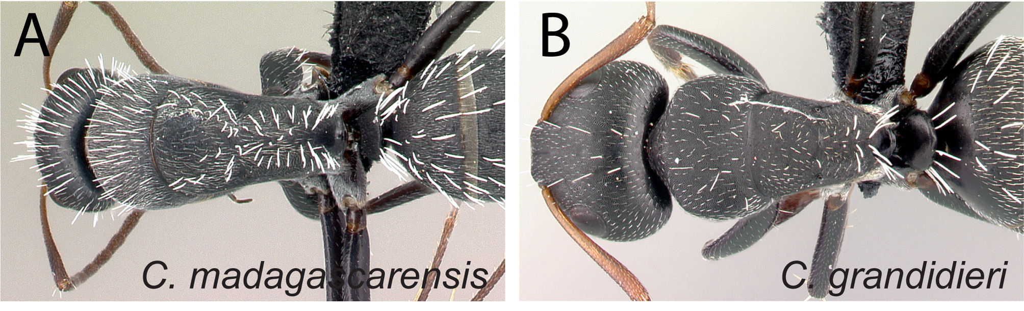
( Figures 4 View FIGURE 4 B, 8C, 10B, 13, 22)
Camponotus grandidieri Forel, 1886: 3 View in CoL View Cited Treatment . Lectotype minor worker, present designation, Madagascar (Voeltzkow), AntWeb CASENT0101121 ( NHMB) [examined] . Paralectotypes: 4 workers with same data as lectotype but specimen coded: CASENT0101120 ( NHMB) ; CASENT0101368, CASENT0101369, CASENT0101370 (MHNG) and 3 males on same pin with specimen code CASENT0101371 (MHNG) [examined]. [As subspecies of Camponotus foraminosus: Mayr, 1893: 195 View in CoL ; Forel, 1907: 14. Revived to a species status: Forel, 1914: 270. Combination in Camponotus (Myrmotrema) View in CoL : Forel, 1913: 145; Wheeler, 1922a: 1050; Emery, 1925: 132; Bolton, 1995: 131].
Camponotus grandidieri atrabilis Santschi, 1915: 269 View in CoL , 273. Lectotype minor worker, present designation, Madagascar, Toamasina province, Sainte Marie (Voeltzkow), AntWeb CASENT0101122 ( NHMB) [examined] . Paralectotypes: 2 workers of same data as lectotype but with specimen code: CASENT0101123 ( NHMB), CASENT0102452 ( MHNG). [Original combination in Camponotus (Myrmotrema) View in CoL ; Wheeler, 1922a: 1051; Emery, 1925: 132; Bolton, 1995: 86]. Syn. n.
Camponotus grandidieri comorensis Santschi, 1915: 269 View in CoL , 274. Lectotype major worker, present designation, Comoros Islands, Grande Comores ( H. Pobéguin), AntWeb CASENT0101125 ( NHMB) [examined] . Paralectotype worker of same data as lectotype but with specimen code: CASENT0101124 ( NHMB). [Combination in Camponotus (Myrmotrema) View in CoL : Forel, 1913: 145; Wheeler, 1922a: 1051; Emery, 1925: 132; Bolton, 1995: 93]. Syn. n.
Diagnosis. Body color black. A few pairs of whitish erect hairs confined to posteromedian portion of head; gap between two hairs on promesonotum usually larger than length of hair. Erect hairs on uppermost portion of petiolar node, posterodorsal angle of propodeum, and junction between lateral propodeal surface and declivity equal to or longer than distance between posteroventral angle of mesosoma and propodeal spiracle.
Description. Minor worker. In full-face view head small (CS: 1.23±0.13; 1.05–1.64) and as long as broad (CWb/CL: 0.92±0.03; 0.88 – 0.99), but slightly converging anteriorly; posterior margin more or less convex. Median portion of clypeus transversely trapezoidal (ClyL/GPD: 0.66±0.03; 0.60–0.71). Eyes either breaking lateral outlines of head or not, their posterior level located at posterior sixth portion of head (PoOc/CL: 0.16±0.01; 0.15– 0.19). Anterior clypeal margin truncate with obtuse lateral angle; posterior margin weakly notched medially. Mandible triangular, apical margin armed with six sharp teeth. Antennal scape long, approximately its distal portion surpassing posterior cephalic margin. In lateral view, outline of promesonotal dorsum broadly convex, without anterior and dorsolateral margination; propodeal dorsum inclined posteriorly. In dorsal view, mesosoma widest at level of pronotum and decreasing in width toward propodeal declivity. Propodeal spiracle opening slitlike. Petiolar node scalelike and tapering dorsally. Mesotibial and metatibial spurs pectinate.
Dorsolateral portion of head and mesosoma finely and densely reticulate punctate, punctures on lateral portion of mesosoma much larger. Gastral tergites with imbricate sculpture or much finer and denser reticulate punctures anteriorly, that become sparser posteriorly. Mandible imbricate superimposed with sparse piligerous punctures. Whitish erect hairs thinner and shorter on head and pronotum, becoming thicker from mesonotum through petiolar node and gastral segments. Hairs arranged as follows: a few pairs on median portion of head from clypeus to near posterior cephalic margin; a few pairs on pronotum, one to three pairs on mesonotum, scattered on propodeal dorsum and junction of lateral propodeal surface and declivity; a row on upper half of posterolateral margin of petiolar node. Some erect hairs on dorsum of petiolar node, posterodorsal angle of propodeum and junction between lateral propodeal surface and declivity equal to or longer than distance between posteroventral angle of mesosoma and opening of propodeal spiracle. On mesosoma, pubescence shorter than distance between hairs; on gastral tergites pubescence longer than distance between hairs; pubescence lacking on upper half of mesopleuron. Body color black and dull; appendages basally reddish or dark brown, apical portion and antennae brown to light brown.
Major worker. With characteristics of minor worker, except: head much larger (CS: 1.97±0.21; 1.56 – 2.21; CWb/CL: 1.03±0.04; 0.95–1.08); lateral margins slightly convex and converging to base of more robust mandibles. Apical margin of mandible with up to seven teeth. Median portion of clypeus more rectangular (ClyL/GPD: 0.88±0.07; 0.78–0.97). Eyes located more medially (CWb/CL: 1.03±0.04; 0.95 – 1.08; CW/CL: 0.92±0.02; 0.89– 0.95) and more anteriorly, their posterior level on posterior fifth of head (PoOc/CL: 0.20±0.01; 0.18–0.23). One fifth of apical portion of scape extending beyond posterior cephalic margin. In dorsal view, small portion of metanotum visible along midline of mesosoma, between metanotal groove and propodeum. Sculpture of lateral portion of head from near base of mandible, along level of interior ocular margin, to level of postocular margin imbricate, superimposed with sparse, larger punctures, which are equipped with two to four smaller punctures from which one appressed hair arises medially. More pairs of whitish erect hairs on median portion of head; numerous on promesonotum. Body color the same as minor except mandibles, anterior portion of clypeus, and anterolateral portion of head darker in color.
Discussion. See discussion under C. auropubens .
The species delimitation for C. grandidieri on the basis of qualitative morphology-based analysis is supported by the combination of exploratory analysis of NC-clustering and partitioning methods with the confirmatory analysis of LDA and shape PCA. The species is identified correctly by simple confirmatory LDA at 100% success.
Distribution and biology. Camponotus grandidieri is widespread in Africa and the Malagasy region. In the latter it occupies many different types of habitats, but is absent on Reunion Island. It has been collected from coastal scrub and littoral forest to spiny forest and tropical dry forest through montane rainforest and savannah woodland. It is also known from mangrove forest and human-dominated areas such as urban gardens and roadsides. Across these habitats, colony nests have been found most often in dead branches above the ground and in rotten logs, and rarely in dead tree stumps, rot pockets and trunks of live trees, under rocks, and under root mats and litter on rocks. Individual workers forage on the ground and on lower vegetation.
Additional material examined. COMOROS: Anjouan: Bimbini , -12.19635, 44.23752, 5 m, coastal scrub, mangrove, ( B.L. Fisher et al.) ( CASC) ; -12.18771, 44.35929, 65 m, coastal roadside, (B.L. Fisher et al.) (CASC); - 12.38051, 44.50217, 20 m, coastal scrub, (B.L. Fisher et al.) (CASC); -12.18771, 44.35929, 65 m, coastal roadside, (B.L. Fisher et al.) (CASC); -12.25764, 44.38915, 20 m, along roadside, (B.L. Fisher et al.) (CASC); -12.22265, 44.2882, 10 m, coastal scrub, along road, (B.L. Fisher et al.) (CASC); Grande Comores: Domani , -11.51778, 43.28, 25 m, coastal scrub, ( B.L. Fisher et al.) ( CASC) ; Domani , -11.48805, 43.2777, 5 m, mangroves, ( B.L. Fisher et al.) ( CASC) ; Goudjoulachamle , -11.44826, 43.27373, 80 m, coastal scrub on lava, ( B.L. Fisher et al.) ( CASC) ; Pidjani , -11.75447, 43.45148, 35 m, coastal scrub, ( B.L. Fisher et al.) ( CASC) ; Trou du Prophète , -11.38087, 43.31335, 10 m, coconut plantation on beach, ( B.L. Fisher et al.) ( CASC) ; Mohéli: Lac Boundouni , -12.37915, 43.85165, 25 m, dry forest, ( B.L. Fisher et al.) ( CASC) ; Madahali , -12.37421, 43.86857, 50 m, coastal dry forest scrub, ( B.L. Fisher et al.) ( CASC) ; Ouallah , -12.34234, 43.66851, 1 m, mangrove, ( B.L. Fisher et al.) ( CASC) ; Ouallah , -12.32717, 43.65952, 10 m, coastal scrub, ( B.L. Fisher et al.) ( CASC) ; (Vöeltzkow) (NHMB); EUROPA ISLAND: [ Insel Europa Westlich von Madagascar], ( Voeltzkow) ( MHNG) ; Europa Island, -22.34775, 40.37041, 10 m, spiny forest on coral, ( B.L. Fisher) ( CASC) ; -22.39054, 40.37935, 15 m, coastal dune vegetation, (B.L. Fisher) (CASC); -22.34775, 40.37041, 10 m, spiny forest on coral, (B.L. Fisher) (CASC); -22.33909, 40.38752, 8 m, coastal dune vegetation, (B.L. Fisher) (CASC); MADAGASCAR: Province Antsiranana: [ Madagascar], ( NHMB) ; [Nosibé], (Völtzkow) (MHNG); Ambanja , -13.68268, 48.45245, 30 m, urban/garden, ( B.L. Fisher et al.) ( CASC) ; Ambilobe , -13.19728, 49.04868, 61 m, urban/garden, ( B.L. Fisher et al.) ( CASC) ; Ambilobe , -13.19728, 49.04868, 61 m, urban/garden, ( B.L. Fisher et al.) ( CASC) ; Ambondrobe, 41.1km 175° Vohemar , -13.71533, 50.10167, 10 m, littoral rainforest, ( B.L. Fisher) ( CASC) ; Andrafiabe, 2.6 km E; Reserve Special d'Ankarana , Antsiranana Province, -12.91667, 49.05, forest edge in savanna, ( M.E. Irwin & E.I. Schlinger) ( CASC) ; Antalaha , -14.9013, 50.28095, 23 m, urban/garden, ( B.L. Fisher et al.) ( CASC) ; Antongombato , 2.2 km SW Antsiranana, - 12.37285, 49.22893, 74 m, urban/garden, ( B.L. Fisher et al.) ( CASC) ; Antsaraingy , -12.89492, 49.65785, 13 m, savannah woodland, ( B.L. Fisher et al.) ( CASC) ; Antsaraingy , -12.89713, 49.65916, 37 m, littoral forest, ( B.L. Fisher et al.) ( CASC) ; Antsiranana, -12.27777, 49.29155, 43 m, urban/garden, ( B.L. Fisher et al.) ( CASC) ; Daraina , -13.255, 49.61667, 100 m, roadside, ( B.L. Fisher) ( CASC) ; Orangea dry forest, Baie de dune 900 m E of Camps Minier , -12.23283, 49.3665, 152 m, dry forest, ( Mike, Rinha) ( CASC) ; Forêt Ambato, 26.6 km 33° Ambanja , -13.4645, 48.55167, 150 m, rainforest, ( B.L. Fisher) ( CASC) ; Galoko chain, Mont Galoko , -13.58745, 48.71419, 380 m, rainforest, ( B.L. Fisher et al.) ( CASC) ; Nosy Faly , -13.36435, 48.49137, 40 m, open secondary vegetation, ( B.L. Fisher et al.) ( CASC) ; Nosy faly, Tafiambotry , 35.3 km N Ambanja, -13.3654, 48.48775, 7 m, littoral rainforest, ( B.L. Fisher et al.) ( CASC) ; Rés. Analamerana, 28.4 km 99° Anivorano-Nord , -12.74667, 49.49483, 60 m, tropical dry forest, ( B.L. Fisher) ( CASC) ; Sakaramy 7 km N of Joffre Ville, -12.33333, 49.25, 360 m, low rain forest in open area, ( Mike, Frank, Rinha) ( CASC) ; Sambava , -14.26145, 50.16295, 23 m, urban/ garden, ( B.L. Fisher et al.) ( CASC) ; Taizambato , 22.9 km NE Ambanja, -13.5092, 48.56722, 16 m, coconut plantation, ( B.L. Fisher et al.) ( CASC) ; Vohemar , -13.37723, 50.0205, 25 m, cultivated land, ( B.L. Fisher et al.) ( CASC) ; Vohemar , -13.35967, 50.0039, 16 m, urban/garden, ( B.L. Fisher et al.) ( CASC) ; 7 km N Joffre Ville [camp 2 of Fisher ], -12.33333, 49.25, 360 m, in dry forest, (R. Harin'Hala) ( CASC) ; Montaigne Francais , -12.325, 49.33333, 150 m, along forested limestone ridge, (R. Harin'Hala) ( CASC) ; Parc National Montagne d'Ambre [first campsite], -12.51444, 49.18139, 960 m, rainforest, (R. Harin'Hala) ( CASC) ; Parc National Montagne d'Ambre [lemur trail], -12.51667, 49.18333, 975 m, rainforest, (R. Harin'Hala) ( CASC) ; Parc National Montagne d'Ambre [ Petit Lac road], -12.52028, 49.17917, 1125 m, rainforest, (R. Harin'Hala) ( CASC) ; Sakalava Beach [vegetated beach dunes], -12.26278, 49.3975, 10 m, across sandy trail in dwarf litoral forest, (R. Harin'Hala) ( CASC) ; Province Fianarantsoa: Ampandravelo II Non Protected Area , 10.78 km NE Ranohira, -22.53917, 45.51548, 873 m, shrubland, ( A. Ravelomanana) ( CASC) ; dry wash, 1 km E of Isalo National Park Interpretive Center , Fianarantsoa Prov., -22.62667, 45.35817, 885 m, dry wash, (R. Harin'Hala) ( CASC) ; Forest d' Ambalamanakana, - 20.73333, 47.2, (A. Pauly) (CASC); Ampangabe III Non Protected Area , 21.26 km W Itremo, -20.6125, 46.60883, 1412 m, savannah woodland, ( A. Ravelomanana) ( CASC) ; Antohatsahomby III Non Protected Area , 22.79 km NW Itremo, -20.54806, 46.58599, 1499 m, Uapaca woodland, ( A. Ravelomanana) ( CASC) ; Forêt d'Atsirakambiaty , 7.6 km 285° WNW Itremo, -20.59333, 46.56333, 1550 m, grassland, ( Fisher, Griswold et al.) ( CASC) ; Horombe Region, District of Ihosy , Betapia ( Border of Fianarantsoa and Tulear ), 9 km SW of Ilakaka Saphir town, -22.62883, 45.36117, 1036 m, Uapaca forest , ( Rin'ha, Mike) ( CASC) ; Manakara , -22.14817, 48.02267, 10 m, urban gardens, coastal Casuarina equisetifolia, ( B.L. Fisher et al.) ( CASC) ; Province Mahajanga: Antsalova , -18.68333, 44.61667, 100 m, ( D.C. Lees) ( PSWC) ; Bemeraha , 9 km E Antsalova, -18.65, 44.71667, tsingy, ( D.C. Lees) ( PSWC) ; Forêt de Tsimembo , 8.7 km 336° NNW Soatana, -19.02139, 44.44067, 20 m, tropical dry forest, ( Fisher, Griswold et al.) ( CASC) ; Melaky Region, District of Maintirano , Asondrodava dry forest against dune, 15 km N of Maintirano, -17.96533, 44.0355, 16 m, dry forest, ( Irwin, Rinha) ( CASC) ; Melaky Region, District of Besalampy , Marofototra palm forest, 17 km W of Besalampy, -16.72167, 44.42367, 10 m, palm trees on sand, ( Irwin, Rinha) ( CASC) ; Parc National de Baie de Baly, 12.4 km 337° NNW Soalala , -16.01, 45.265, 10 m, tropical dry forest, ( Fisher, Griswold et al.) ( CASC) ; Province Toamasina: Ste Marie , ( Voeltzkow) ( MHNG) ; ( Tamatave), Prison de Tamatave , -18.16667, 49.38333, ( A. Pauly) ( CASC) ; 2.1 km 315° Mahavelona , - 17.67017, 49.49583, 30 m, eucalyptus plantation, ( B.L. Fisher et al.) ( CASC) ; Ambalahasina , 62.4 km 19° Toamasina, -17.59452, 49.46785, 15 m, coastal scrub, ( B. Blaimer, F.N. Raharimalala) ( CASC) ; Ampasimbe , 118 km 17° Toamasina, -17.09283, 49.47783, 25 m, urban garden, ( B. Blaimer, F.N. Raharimalala) ( CASC) ; Ampasina-Maningory , 104 km 13° Toamasina, -17.21467, 49.4055, 20 m, urban garden, ( B. Blaimer, F.N. Raharimalala) ( CASC) ; Andasibe National Park , botanic garden near entrance, West of ANGAP office, -18.92639, 48.40783, 1025 m, tropical forest, ( M.E. Irwin, R. Harin'Hala) ( CASC) ; Anosintany , 139 km 21° Toamasina, - 16.91117, 49.58867, 10 m, coastal scrub, ( B. Blaimer, F.N. Raharimalala) ( CASC) ; Antaratasy , 43.5 km 23° Toamasina, -17.76733, 49.47767, 15 m, urban garden, ( B. Blaimer, F.N. Raharimalala) ( CASC) ; Antetezambaro , 16 km 21° Toamasina, -17.05283, 49.567, 10 m, urban garden, ( B. Blaimer, F.N. Raharimalala) ( CASC) ; Brickaville , -18.82183, 49.07017, 24 m, urban/garden, ( B.L. Fisher et al.) ( CASC) ; Moramanga, 29 km E of Moramanga, Andasibe National Park , -18.93767, 48.41167, 822 m, rainforest, ( Mike, Rin'ha) ( CASC) ; Fenoarivo , 85.7 km 13° Toamasina, -17.38117, 49.415, 10 m, beach/coastal scrub, ( B. Blaimer, F.N. Raharimalala) ( CASC) ; Ile Sainte Marie, Forêt Ambohidena, 22.8 km 44° Ambodifotatra , -16.82433, 49.96417, 20 m, littoral rainforest, ( B.L. Fisher et al.) ( CASC) ; Mahanoro , -19.89933, 48.80883, 15 m, urban/garden, ( B.L. Fisher et al.) ( CASC) ; Mahavelona ( Foulpointe), -17.66667, 49.5, clay forest, lagoon forest, between Canal des Pangalanes and beach, Forest Analalava , ( A. Pauly) ( CASC) ; Mananara , -16.16798, 49.76768, 19 m, urban garden, ( B.L. Fisher et al.) ( CASC) ; Maroantsetra , -15.43442, 49.73907, 19 m, urban garden, ( B.L. Fisher et al.) ( CASC) ; Nosy Mangabe , - 15.5, 49.76667, < 5 m, littoral vegetation, ( P.S. Ward) ( PSWC) ; Parcelle E 3 Tampolo , -17.28104, 49.43012, 10 m, littoral forest, ( Malagasy ant team) ( CASC) ; Station Forestière Tampolo , 10 km NNE Fenoarivo Atn., -17.2825, 49.43, 10 m, littoral rainforest, ( B.L. Fisher) ( CASC) ; Tamatave , -18.15467, 49.41267, 20 m, urban/garden, ( B.L. Fisher et al.) ( CASC) ; Tampolo , -17.28333, 49.41667, 10 m, littoral forest, ( Malagasy ant team) ( CASC) ; Tanambao Nosibe , 29.6 km 23° Toamasina, -17.89117, 49.45617, 15 m, coastal scrub, ( B. Blaimer, F.N. Raharimalala) ( CASC) ; Toamasina-Port , -18.16033, 49.42717, 5 m, urban garden, ( B. Blaimer, F.N. Raharimalala) ( CASC) ; Toamasina-Ville , -18.15517, 49.4095, 10 m, urban garden, ( B. Blaimer, F.N. Raharimalala) ( CASC) ; Vatomandry , -19.33283, 48.9795, 16 m, urban/garden, ( B.L. Fisher et al.) ( CASC) ; Province Toliara: 3.7 km 102° ESE Belo sur Mer , -20.73472, 44.04, 10 m, spiny forest/thicket, ( Fisher, Griswold et al.) ( CASC) ; Anosy Region, District of Amboasary , 58 km SW of Fort Dauphin, 8 km NW of Amboasary, Berenty Special Reserve , -25.021, 46.3055, 36 m, spiny forest, ( Mike, Rin'ha) ( CASC) ; Atsimo-Andrefana Region , -23.45314, 43.76448, 20 m, coastal spiny bush on sandy soil, ( B.L.Fisher, F.A.Esteves et al.) ( CASC) ; Atsimo-Andrefana Region, Sarodrano , - 23.52243, 43.74031, 15 m, Didiereaceae forest on sand dunes, ( B.L.Fisher, F.A.Esteves et al.) ( CASC) ; Forêt de Beroboka , 5.9 km 131° SE Ankidranoka, -22.23306, 43.36633, 80 m, tropical dry forest, ( Fisher, Griswold et al.) ( CASC) ; Forêt de Tsinjoriaky , 6.2 km 84° E Tsifota, -22.80222, 43.42067, 70 m, spiny forest/thicket, ( Fisher, Griswold et al.) ( CASC) ; Makay Mts. , -21.34228, 45.18314, 410 m, gallery forest on sandy soil, ( B.L. Fisher et al.) ( CASC) ; Manderano , -23.5275, 44.08833, 70 m, gallery forest, ( Frontier Project) ( CASC) ; Parc National d'Andohahela, Forêt de Manatalinjo , 33.6 km 63° ENE Amboasary, 7.6 km 99° E Hazofotsy, -24.81694, 46.61, 150 m, spiny forest/thicket, ( Fisher, Griswold et al.) ( CASC) ; Parc National de Kirindy Mite , 16.3 km 127° SE Belo sur Mer, -20.79528, 44.147, 80 m, tropical dry forest, ( Fisher, Griswold et al.) ( CASC) ; Ranobe , -23.04085, 43.61012, 30 m, gallery forest, Frontier Wilderness Project, ( CASC) ; Sakaraha , -22.91233, 44.53283, 470 m, urban/garden, ( B.L. Fisher et al.) ( CASC) ; Toliara, -23.3575, 43.669, 20 m, urban/garden, ( B.L. Fisher et al.) ( CASC) ; Ambohimahavelona village 33 km NE of Tulear, Andoharano dry forest, -23.44083, 43.89967, 43-46 m, dry forest/ spiny bush, ( ME Irwin, Rin'ha) ( CASC) ; Mikea Forest , deciduous dry forest, Tulear Province, -22.90367, 43.4755, 30 m, deciduous dry forest, (R. Harin'Hala) ( CASC) ; near ANGAP office, Zombitse National Park , Tulear Province, -22.8865, 44.69217, 840 m, deciduous spiny forest, (R. Harin'Hala) ( CASC) ; 11km SE Ampasimanolotra (= Brickaville ), -18.9, 49.13333, 5 m, littoral vegetation, ( P.S. Ward) ( PSWC) ; Andilana, Nosy Bé , -13.25, 48.18333, < 5 m, ( D.M.Olson) ( PSWC) ; Manankinany , -17.03333, 49.53333, ( L.A. Nilsson) ( PSWC) ; Nosy Be: 4km ESE Andoany (= Hellville ), -13.41667, 48.3, < 5 m, littoral vegetation, ( P.S. Ward) ( PSWC) ; Rantabe, N Soanierana Ivongo, -16.88333, 49.65, (L.A. Nilsson) (PSWC); MAURITIUS: Rodrigues: Anse Fumier , -19.7149, 63.4163, ( Michael Madl) ( CASC) ; Baie Pistache , -19.7149, 63.4163, ( Michael Madl) ( CASC) ; Citronelle , - 19.7149, 63.4163, ( Michael Madl) ( CASC) ; Grand Montagne , -19.70572, 63.46498, 358 m, ( L. Lach) ( CASC) ; Balaclava , ( Michael Madl) ( CASC) ; Botanical Gardens , -20.10628, 57.58033, 100 m, ( A.V. Suarez) ( CASC) ; IAA, (S. Buckland) (N. Cole) (L. Lach) (CASC); Ile aux Aigrettes , -20.41883, 57.7305, 1 m, coastal scrub, ( B.L. Fisher et al.) ( CASC) ; Ile Aux Aigrettes, -20.41902, 57.73018, on island, ( A.V. Suarez) ( CASC) ; Ile Marianne, - 20.36667, 57.78333, 5 m, ( L. Lach) ( CASC) ; La Nicolière Reserve , ( Michael Madl) ( CASC) ; La Nicolière Reserve, ( Michael Madl) ( Brice Noonan , University of Mississippi); Le Pouce Mt . , 700–800 m, native forest, ( W.L. Brown) ( MCZC) ; Le Pouce , ( L. Lach) ( CASC) ; Magenta , -20.31667, 57.45, 150 m, dry closed forest, ( P.S. Ward) ( UCDC) ; Mahebourg , ( N. Room) ( CASC) ; Montagne du lion, -20.36306, 57.72611, 393 m, Wet II vegetation, many traveler's palms, ( J. Casquet) ( CASC) ; Perrier Nature Reserve , -20.35207, 57.49417, 564 m, ( A.V. Suarez) ( CASC) ; Pieter Both Mt. , Moka Range, -20.19217, 57.55533, 770 m, closed vegetation, ( B.L. Fisher et al.) ( CASC) ; Port Louis, ( F. Blard) ( UCDC) ; Port Louis Waterfront, -20.15528, 57.5, ( A.V. Suarez) ( CASC) ; Scaevola , ( L. Lach) ( CASC) ; Side of Le Pouce , -20.19167, 57.50667, 176 m, 100% butterfly liana ( Hiptage benghalensis, invasive),( J.Casquet) ( CASC) ; Souillac, ( Michael Madl) ( Brice Noonan, University of Mississippi); Souillac , ( Michael Madl) ( CASC) ; SSR Botanical Gardens , -20.10757, 57.57923, ( L. Lach) ( CASC) ; MAYOTTE: Coconi: DAF Campus , -12.83333, 45.13333, ( R. Jocqué) ( CASC) ; Combani , south coast track between the airport and lagoon, -12.81069, 45.2793, 7 m, native littoral and secondary vegetation, Jacques Rochat /Insectarium de La Réunion, ( CASC) ; Convalescence , -12.76667, 45.18333, road verges, ( R. Jocque & G. DeSmet) ( CASC) ; Convalescence , north coast from airport, -12.80099, 45.28701, 1 m, monospecific mangrove ( Sonneratia alba) ( J. Rochat, S. Gasnier, G. Paulus /Insectarium de La Réunion) ( CASC) ; Dapani , -12.97495, 45.16183, 1 m, mangrove, coastal scrub, ( B.L. Fisher et al.) ( CASC) ; Dapani, Labattoir , western slope of the hill, -12.79216, 45.27709, 71 m, secondary thicket and diverse vegetation, ( CASC) ; Dziani Karihani, Ilang-Ilang plantation, -12.78333, 45.11667, ( R. Jocque & G. DeSmet) ( CASC) ; Mont Chongui summit, -12.99567, 45.13428, 550 m, rainforest, ( B.L. Fisher et al.) ( CASC) ; Mt. Benara , track to reserve gate, -12.86667, 45.18333, 250 m, ( R. Jocque & G. DeSmet) ( CASC) ; Ngouja , grazed dry forest, ( R. Jocqué) ( CASC) ; Petite Terre , -12.79119, 45.29403, 125 m, coastal scrub degraded, ( B.L. Fisher et al.) ( CASC) ; Petite Terre, Dziani Dzaha , -12.78333, 45.11667, ( R. Jocque & G. DeSmet) ( CASC) ; Tanaraki , -12.75754, 45.0678, 10 m, coastal scrub, ( B.L. Fisher et al.) ( CASC) ; Tsingoni , -12.78333, 45.1, mangrove, ( R. Jocque & G. DeSmet) ( CASC) ; SEYCHELLES: Aldabra Atoll: Malabar Island, -9.37417, 46.43852, 5 m, casuarina forest, ( S.M. Goodman) ( Brice Noonan, University of Mississippi); Picard , old settlement, -9.39606, 46.20465, 2 m, coastal scrub, ( B.L. Fisher) ( CASC) ; Aride Island, -4.21407, 55.6682, 10 m, native forest, ( B.L. Fisher et al.) ( CASC) ; Aride Island, -4.21167, 55.66924, 75 m, mixed forest, ( B.L. Fisher et al.) ( CASC) ; Aride Island, ( J. Gerlach) ( CASC) ; Conception Island, -4.66527, 55.37086, 20 m, mixed forest, ( B.L. Fisher et al.) ( CASC) ; Conception Island, -4.66311, 55.36821, 65 m, mixed forest, ( B.L. Fisher et al.) ( CASC) ; Cosmoledo Atoll : [Wizard Island], on the dune, next to Tournefortia argentea , -9.75306, 47.64889, < 10 m, lowland coastal, coralline island, ( G. Galman) ( CASC) ; Cousine , -4.35107, 55.64785, ( Robert Andrew Bell) ( CASC) ; Cousine , -4.3507, 55.64777, P. grandis forest, ( René Gaigher) ( CASC) ; Curieuse Island, -4.28364, 55.72697, 5 m, mangrove, ( B.L. Fisher et al.) ( CASC) ; Félicité Island, -4.31991, 55.86909, 75 m, coastal scrub, ( B.L. Fisher et al.) ( CASC) ; Félicité Island, -4.32012, 55.86683, 20 m, coastal scrub, ( B.L. Fisher et al.) ( CASC) ; La Digue Island, -4.34419, 55.84187, 200 m, mixed native forest, ( B.L. Fisher et al.) ( CASC) ; La Digue Island, - 4.35613, 55.84331, 300 m, forest, ( B.L. Fisher et al.) ( CASC) ; La Digue Island, -4.34419, 55.84187, 25 m, coastal scrub, ( B.L. Fisher et al.) ( CASC) ; La Digue Island, Veuve Réserve , -4.35697, 55.82791, 15 m, littoral forest, ( B.L. Fisher et al.) ( CASC) ; L'llot Island, ( J. Gerlach) ( CASC) ; Mahé Island: Baie Lazare, ( Vincent Robert) ( CASC) ; Cascade, -4.67494, 55.49819, 150 m, roadside, ( B.L. Fisher et al.) ( CASC) ; Glacis la Réserve, -4.71023, 55.50435, 300 m, forest and glacis, ( B.L. Fisher et al.) ( CASC) ; Mont Copolia , -4.65121, 55.45835, 520 m, forest, ( B.L. Fisher et al.) ( CASC) ; Mont Serbert , -4.67859, 55.50408, 490 m, glacis vegetation, ( B.L. Fisher et al.) ( CASC) ; Port Launay , -4.65323, 55.40207, 12 m, mangrove, ( B.L. Fisher et al.) ( CASC) ; Port Launay , -4.65892, 55.41067, 10 m, mangrove, ( B.L. Fisher et al.) ( CASC) ; Port Launay , -4.65892, 55.41067, 10 m, mangrove, ( B.L. Fisher et al.) ( CASC) ; Vingt Cinq Sous , -4.62894, 55.40912, 460 m, mixed forest along road, ( B.L. Fisher et al.) ( CASC) ; Mare Aux Cochon , ( J. Gerlach) ( CASC) ; Praslin , -4.34985, 55.7489, dry palm forest/scrub, ( Robert Andrew Bell) ( CASC) ; Praslin Island: -4.33457, 55.74543, in palm forest, ( Robert Andrew Bell) ( CASC) ; Praslin , -4.34977, 55.72881, 20 m, coastal scrub, ( B.L. Fisher et al.) ( CASC) ; Praslin , -4.33374, 55.72235, 10 m, mangrove, coconut, beach scrub, ( B.L. Fisher et al.) ( CASC) ; Fond Peper , -4.33341, 55.7408, 200 m, mixed forest, ( B.L. Fisher et al.) ( CASC) ; Newcome , -4.301, 55.6926, 130 m, palm forest, ( B.L. Fisher et al.) ( CASC) ; Praslin tower, -4.34093, 55.74514, 370 m, mixed forest, ( B.L. Fisher et al.) ( CASC) ; Silhouette Island: -4.49076, 55.25341, 20 m, coastal scrub, ( B.L. Fisher et al.) ( CASC) ; La Passe , -4.48484, 55.25074, 35 m, park/garden, ( B.L. Fisher et al.) ( CASC) ; on coastal path to Anse Mondon , -4.46951, 55.24159, 10 m, coastal scrub, ( B.L. Fisher et al.) ( CASC) ; on path to Anse Mondon , -4.46893, 55.22936, 255 m, forest, ( B.L. Fisher et al.) ( CASC) ; on path to Anse Mondon , -4.46893, 55.22936, 255 m, forest, ( B.L. Fisher et al.) ( CASC) ; St. Pierre, ( J. Gerlach) ( CASC) ; Vaches Marins , ( J. Gerlach) ( CASC) .
No known copyright restrictions apply. See Agosti, D., Egloff, W., 2009. Taxonomic information exchange and copyright: the Plazi approach. BMC Research Notes 2009, 2:53 for further explanation.
|
Kingdom |
|
|
Phylum |
|
|
Class |
|
|
Order |
|
|
Family |
|
|
Genus |
Camponotus grandidieri Forel
| Rakotonirina, Jean Claude, Csősz, Sándor & Fisher, Brian L. 2017 |
Camponotus grandidieri atrabilis
| Bolton 1995: 86 |
| Emery 1925: 132 |
| Wheeler 1922: 1051 |
| Santschi 1915: 269 |
Camponotus grandidieri comorensis
| Bolton 1995: 93 |
| Emery 1925: 132 |
| Wheeler 1922: 1051 |
| Santschi 1915: 269 |
| Forel 1913: 145 |
Camponotus grandidieri
| Bolton 1995: 131 |
| Emery 1925: 132 |
| Wheeler 1922: 1050 |
| Forel 1914: 270 |
| Forel 1913: 145 |
| Forel 1907: 14 |
| Mayr 1893: 195 |
| Forel 1886: 3 |