
Sphenomorphus meyeri ( Doria 1874 )
|
publication ID |
https://doi.org/ 10.11646/zootaxa.3490.1.1 |
|
publication LSID |
lsid:zoobank.org:pub:A0DB5E47-3CBC-44D7-83A1-5235E9EE289D |
|
DOI |
https://doi.org/10.5281/zenodo.5874680 |
|
persistent identifier |
https://treatment.plazi.org/id/03BF87DA-FFBE-FF93-99E9-73E9FC45E3B0 |
|
treatment provided by |
Plazi |
|
scientific name |
Sphenomorphus meyeri ( Doria 1874 ) |
| status |
|
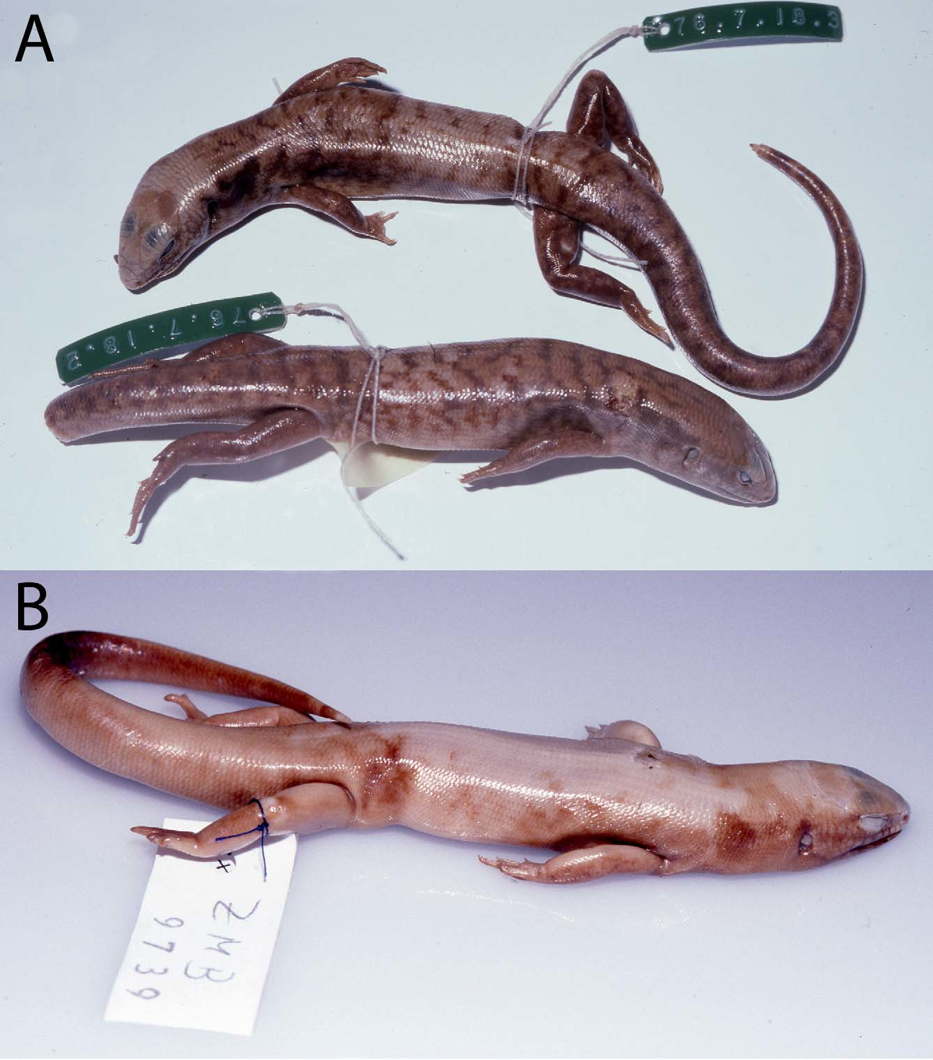
Sphenomorphus meyeri ( Doria 1874)
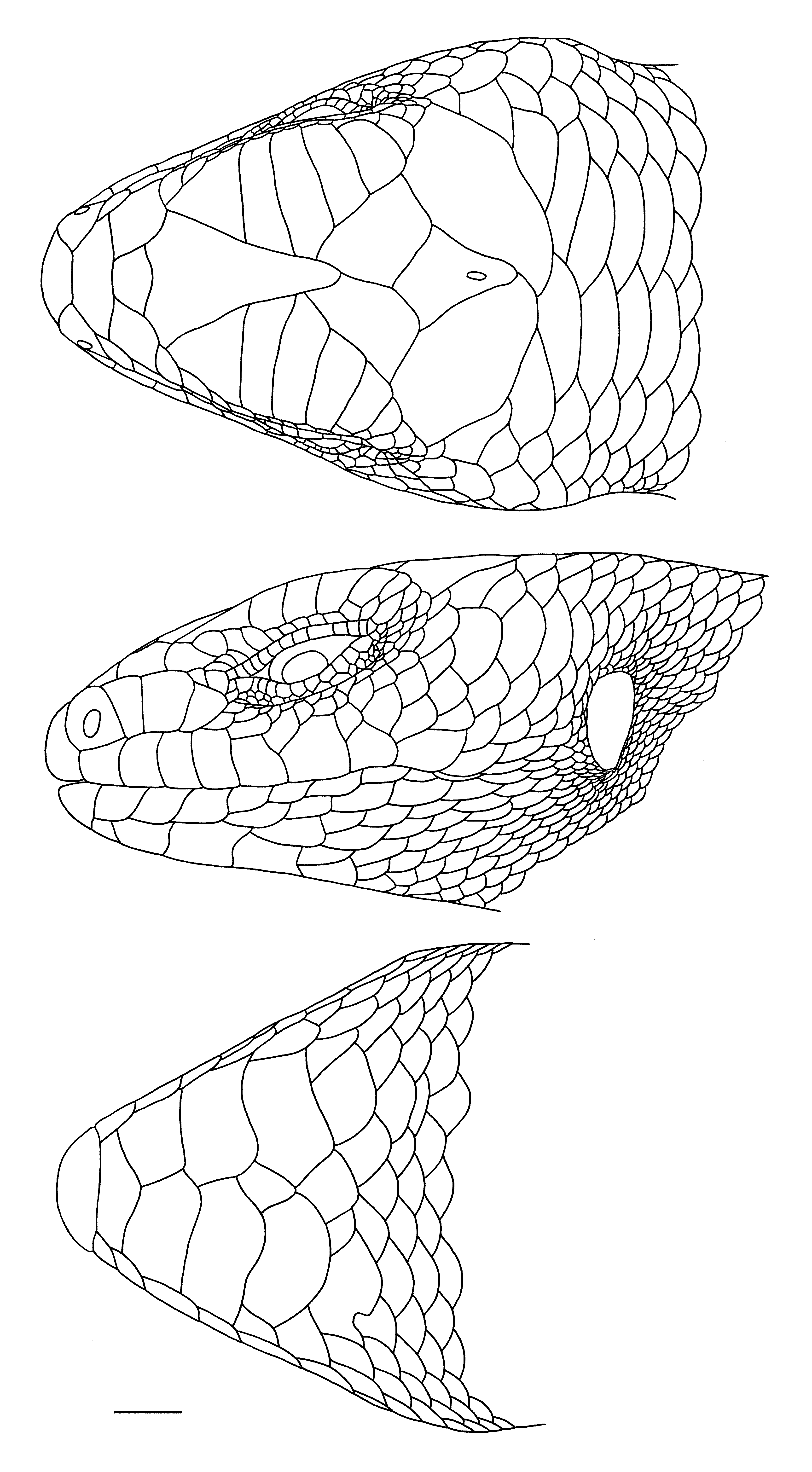
( Figs. 9–13 View FIGURE 9 View FIGURE 10 View FIGURE 11 View FIGURE 12 View FIGURE 13 )
Lygosoma (Hinulia) Meyeri Doria 1874: 332 ; plate 11, fig 13.
Syntypes: BMNH 76.7.18.2–3; MSNG 27877a–d; NHMW 16650:1–2; RMNH. RENA 4253; ZMB 7937a–b, 9739; 12 syntypes not located; type locality Wokan, Aru Islands.
Hinulia papuensis Macleay 1877: 62 View in CoL . Holotype: AM R31847. Type locality Katow, [Binaturi River, Papua New Guinea] .
Diagnosis. This species can be distinguished from all other Sphenomorphus on the basis of the following combination of characters: size large (maximum SVL = 126 mm); prefrontals in contact or separated by an azygous scale; body scales smooth; midbody scales 40–57 (mean = 47.6, sd = 2.71, n = 198); paravertebral scales (A) 76–115 (mean = 94.2, sd = 6.83, n = 191); subdigital lamellae below the fourth toe (A) 14–22 (mean = 17.9, sd = 1.38, n = 187), divided into a larger preaxial series (from which the counts are derived) and a smaller postaxial series; frontal contacting first three (when a total of six) or four (when a total of seven) supraoculars; colour pattern consists of relatively thin, sinuous dark brown crossbars against a light brown background and some indication of a white stripe along the upper lip.
A full analysis of geographic variation in this species will be the subject of a separate paper.
Distribution. Low to mid altitudes (below 1100 m) in the western two thirds of New Guinea, including the Aru Islands and the Raja Ampat Islands ( Fig. 14 View FIGURE 14 ).
Sphenomorphus meyeri [n = 212]
Indonesia: Kepulauan Aru: BMNH 76.7.18.2–3, RMNH. RENA 4253, ZMB 7937–38, 9739 (syntypes of meyeri ), [Wokam], Aru Islands [5°35'S 134°32'E] GoogleMaps ; WAM R109628, R109580, R109583, R109591, Karangguli (5°48'S 134°15'E) GoogleMaps .
Indonesian New Guinea: No precise locality: MNHN 1244, RMNH. RENA 3830a-c .
Papua Barat Province: AMNH 94313, Mt Besar, above Wailebet, 1500', Batanta I., Raja Ampat Is. (0°53'S 130°36'E) GoogleMaps ; BPBM 3122, Kebar Valley, 550 m, Vogelkop (0.867°S 133.083°E) GoogleMaps ; RMNH. RENA 7425a-b, Batanta I., Raja Ampat Is .; 7426a-b, Gagie [Pulau Gag 0°27'S 129°52'E] or Gebe [Pulau Gebe 0°05'S 129°20'E] GoogleMaps ; 30003–05, Kampong Gariau, Jamoer Meer [3°42'S 134°56'E] GoogleMaps ; 30006, Ajamaroe [Ajamaru], Vogelkop [1°14'S 132°12'E] GoogleMaps ; 30007, Manokwari [0°52'S 134°05'E] GoogleMaps ; 30008, Djitmau, Vogelkop [1°14'S 132°20'E] GoogleMaps ; 30009, Toeog, Vogelkop [coordinates unknown] ; 30010, Komara, Vogelkop [?Koemana/Kumawa, Bomberoi Peninsula 3.8333°S 132.8333°E] GoogleMaps ; 30011, Pasir Poetih [=Pasir Putih, Vogelkop, 0°52'S 134°06'E] GoogleMaps .
Papua Province: AMNH 66354, Hollandia, Indonesia [2°32'S 140°41'E] GoogleMaps ; BPBM 3395, Itoda (4.036°S 136.09°E) GoogleMaps ; FMNH 152333, MCZ 28681, Mimika River [ca. 4°43'S 138°28'E] GoogleMaps ; MCZ 68919, Kamu Valley [ca. 3°33'S 136°089'E] ; RMNH. RENA 29982–30000 , Tanah Merah [6°06'S 140°17'E]; 30001–02, Kauh, Digoel River [5°50'S 140°12'E]; 30012–13, Kawakit, Digoel River [5°39'S 140°14'E] ; 30014–16, Katem [5°09'S 140°43'E] .
Papua New Guinea: Western Province: AM R31847 (holotype of papuensis ) , Katow [9°08'S 142°57'E] GoogleMaps ; R64302, AMNH 111724, MCZ 141056 –60, 141064, PNGNM R22359, USNM 195770, Emeti, Bamu River (7°45'S 143°15'E) GoogleMaps ; AM R93236, R 121161, AMNH 105862–64, 106274, MCZ 152326, 152358–59, 152364–66, SAM R11434, Wipim (8°51'S 142°54'E) GoogleMaps ; AMNH 57543, Fly River ; 57902, Daru (9°05'S 143°12'E) GoogleMaps ; 59941, Sturt I., Fly River, (8°10'S 142°15'E) GoogleMaps ; BMNH 1987.523–26, USNM 195880, Oriomo, Oriomo River (8°52'S 143°11'E) GoogleMaps ; 1987.527, Runginae, Ok Mart River [Rumginae Mission, 5°54'S 141°16'E] GoogleMaps ; MCZ 119492, Balimo (8°02'S 142°57'E) GoogleMaps ; 119493–94, 140748, Ningerum (5°42'S 141°07'E) GoogleMaps ; 123990, Menemsore (5°53'S 141°15'E) GoogleMaps ; 134749, Morehead (8°43'S 141°38'E) GoogleMaps , 135501–02, PNGNM R22360, Oriomo Stn (8°52'S 143°11'E) GoogleMaps ; MCZ 137558–59, Mata (8°40'S 141°44'E) GoogleMaps ; 140846, Kuru (8°55'S 143°03'E) GoogleMaps ; 152351–53, Matkomrae (5°49'S 141°09'E) GoogleMaps ; 152354, Old Zim, Oriomo River (8°46'S 143°05'E) GoogleMaps ; 152355, Derongo (5°25'S 141°06'E) GoogleMaps ; 152360–62, Boboa I., Lake Murray (7°01'S 141°30'E) GoogleMaps ; UPNG 8812, 8806A, Kasua (7°11'S 142°55'E) GoogleMaps ; USNM 213383–84, Makapa village, Aramia River, Balimo subprovince (7°57'S 142°34'E) GoogleMaps ; 213385, Samacki River, Aramia River, Balimo subprovince (7°46'S 142°16'E) GoogleMaps ; 213386, Ali village, Aramia River, Balimo subprovince (7°54'S 142°20'E) GoogleMaps . Gulf Province: AMNH 102336, FMNH 170590, MCZ 101249 –69, 101273 –74, 145233–47, 145249–51, PNGNM R24282, SAM R10985, WAM R67634–35, Uraru, Purari River (6°54'S 144°54'E) GoogleMaps ; BMNH 1970.859–60, MCZ 101242 –46, 109236–39, Oroi, Purari River [= Orloli, 7°26'S 145°11'E] GoogleMaps ; BPBM 13120, 13122, 13130, 13164–65, Lakekamu field camp, along east branch of Avi Avi River, 120 m (7.735°S 146.496°E) GoogleMaps ; 13158–59, 13162, PNGNM 25036, 25038, Ivimka, Lakekamu River (7.735°S 146.496°E) GoogleMaps ; MCZ 100440 –41, Camp II, Pio River, 1000' (6°44'S 144°52'E) GoogleMaps , 100442, Weiana, 1500' (6°44'S 144°52'E) GoogleMaps ; 100443, Ining River, Soliabeda [Soliabedo], 1200' (6°40'S 144°55'E) GoogleMaps ; 100444, Camp I, Soliabeda [Soliabedo], 3500' [6°37'S 144°50'E] GoogleMaps ; 100445, Soliabeda [Soliabedo] (6°40'S 144°55'E) GoogleMaps ; 101247, Koni (6°59'S 145°03'E) GoogleMaps ; 101272, Camp III, Nimi River [6°48'S 144°52'E] GoogleMaps ; 101842, Koni, Purari River, 250' (6°59'S 145°03'E) GoogleMaps ; 150877, 30km N, 14 km W Kikori, Kikori River [7°08'S 144°07'E] GoogleMaps ; USNM 518582, 11 km S Tekedu, Ivimka camp (7.4405°S 146.2945°E) GoogleMaps . Central Province: AM R24428, Angabanga River, Kairuku subdivision (8°49'S 146°34'E) GoogleMaps . Sandaun Province: AM R115497, Skgonga River [4°33'S 141°10'E] GoogleMaps ; BPBM 23177–80, Camp 1, Torricelli Mountains, 550 m (3.39329°S 142.52826°E) GoogleMaps . Southern Highlands Province: AM R118731–34, Fau (6°14'S 142°42'E) GoogleMaps ; R118735–39, Waro (6°32'S 143°11'E) GoogleMaps ; R118740, Fogamaiyu (6°31'S 143°05'E) GoogleMaps ; R118741, Namosado (6°15'S 142°47'E) GoogleMaps . Chimbu Province: BPBM 19063, Wera Sera field station, 850 m, Crater Mountain (6°43.43675'S 145°05.5575'E) GoogleMaps .


| MSNG |
Museo Civico di Storia Naturale di Genova 'Giacomo Doria' |
| NHMW |
Naturhistorisches Museum, Wien |
| RMNH |
National Museum of Natural History, Naturalis |
| ZMB |
Museum für Naturkunde Berlin (Zoological Collections) |
| WAM |
Western Australian Museum |
| MNHN |
Museum National d'Histoire Naturelle |
| AMNH |
American Museum of Natural History |
| BPBM |
Bishop Museum |
| FMNH |
Field Museum of Natural History |
| MCZ |
Museum of Comparative Zoology |
| USNM |
Smithsonian Institution, National Museum of Natural History |
| SAM |
South African Museum |
No known copyright restrictions apply. See Agosti, D., Egloff, W., 2009. Taxonomic information exchange and copyright: the Plazi approach. BMC Research Notes 2009, 2:53 for further explanation.