
Psammokalliapseudes granulosus Brum, 1973
|
publication ID |
https://doi.org/ 10.11646/zootaxa.4711.1.2 |
|
publication LSID |
lsid:zoobank.org:pub:B3FFF924-44D6-403A-87B4-62EA2E2907D2 |
|
persistent identifier |
https://treatment.plazi.org/id/03D0975F-FFF4-584C-89F1-D3BABF03F9F2 |
|
treatment provided by |
Plazi |
|
scientific name |
Psammokalliapseudes granulosus Brum, 1973 |
| status |
|
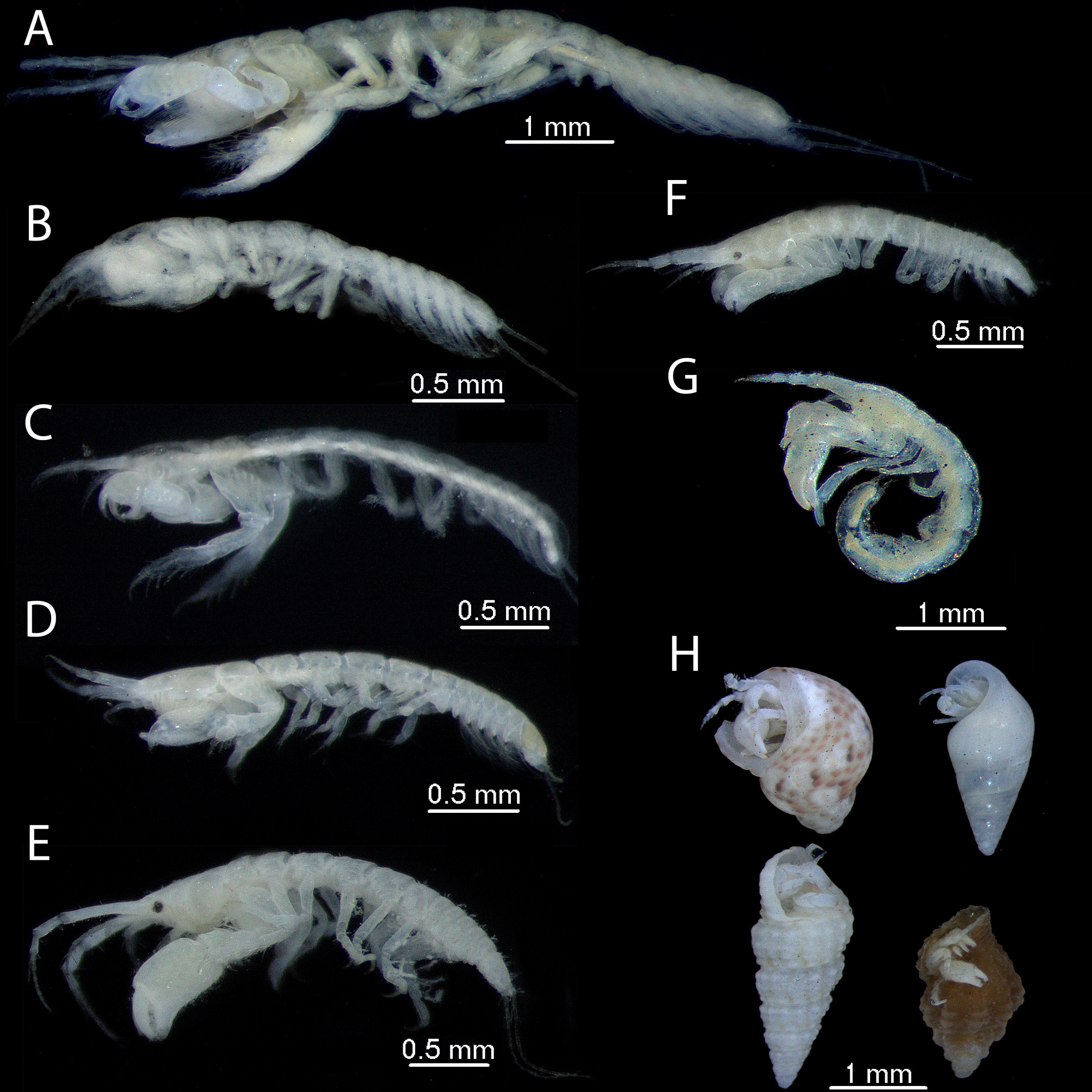
Psammokalliapseudes granulosus Brum, 1973 View in CoL
( Fig. 3 View FIGURE 3 C–D)
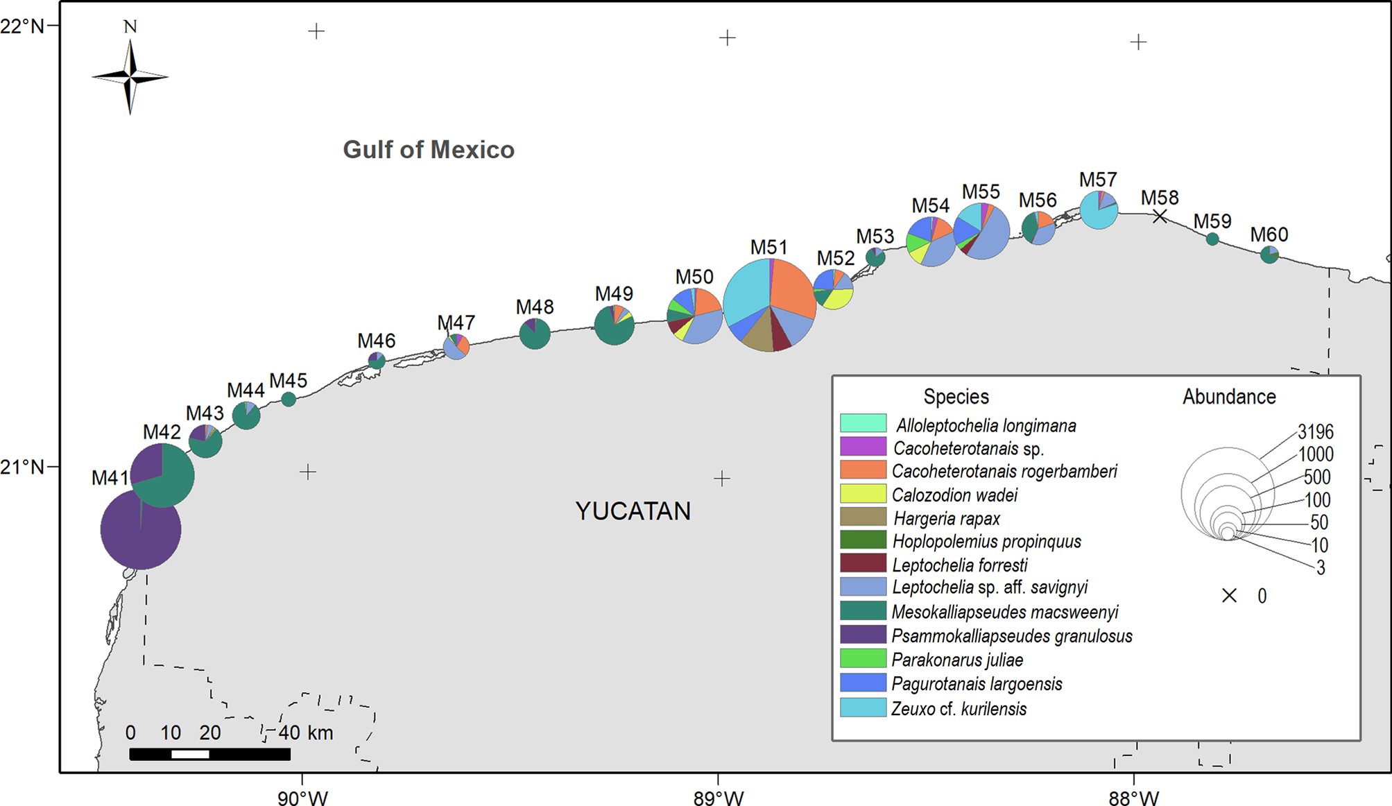
Examined material. TA: 2158 individuals. CNCR 34807 . Tr-Loc: M41- Celestun, Yucatan , Mexico 20°51’43.56’’N 90°24’4.179’’W, 881 ♀, 328 ♀ o, 47 ♀ m, 557♂, 44 juv, five man., 7 May 2005, 26 November 2005, 11 March 2006, coll. AV, SP GoogleMaps ; Tr-Loc : M42- Celestun , Yucatan, Mexico 20°59’9.059’’N 90°21’7.516’’W, 100 ♀, 62 ♀ o, five ♀ m, 88 ♂, five juv, five man., 7 May 2005, 26 November 2005, 11 March 2006, coll. AV, SP GoogleMaps ; Tr-Loc : M43- Celestun , Yucatan, Mexico 21°3’53.319’’N 90°14’57.728’’W, four ♀, five ♀ o, seven ♂, 7 May 2005, 26 November 2005, 11 March 2006, coll. AV, SP GoogleMaps ; Tr-Loc : M46- Chuburna , Yucatan, Mexico 21°15’21.6’’N 89°50’20.288’’W, one ♀, 8 May 2005, 27 November 2005, 12 March 2006, coll. AV, SP GoogleMaps ; Tr-Loc : M48- Chicxulub , Yucatan, Mexico 21°19’21.179’’N 89°27’25.156’’W, two ♀, one ♀ o, two ♂, three juv, 8 May 2005, 27 November 2005, 12 March 2006, coll. AV, SP GoogleMaps ; Tr-Loc : M49- Telchac , Yucatan, Mexico 21°20’41.1’’N 89°15’53.236’’W, three ♀, two ♂, 8 May 2005, 27 Novem- ber 2005, 12 March 2006, coll. AV, SP GoogleMaps ; Tr-Loc : M53- Dzilam , Yucatan, Mexico 21°30’24.619’’N 88°38’1.679’’W, one ♀, 15 May 2005, 13 November 2005, 13 March 2006, coll. AV, SP GoogleMaps ; collected at depths of 0.8–4.6 m, on coarse sand, medium sand, fine sand, and very fine sand GoogleMaps
.
Local distribution. ( Table 1 View TABLE 1 , Fig. 2 View FIGURE 2 ).
Geographical distribution. Atlantic Ocean: Hollywood, Port Everglades, Miami, Lauderdale Fort Florida; GoM: Panama City, Apalachicola, Tampa Bay, Florida Keys, Florida Bay, Veracruz Reef System National Park; Caribbean Sea: Puerto Morelos Reef National Park, Quintana Roo, Puerto Rico, Tobago.
Recognition characters. Rounded rostrum; without eyes; mandibular palp with one simple terminal setae; carpus and propodus of cheliped with long simple setae on inner margin; pereopod-1 with dactylus having three spines on ventral margin and curled sensory setae on dorsal margin. Male cheliped much more robust than in female.
Remarks. This species has its geographical range extended to the southeastern portion of the GoM ( Mexico). It inhabits between 100 and 200 m perpendicular to the shoreline, in fragments of coral rock, sandy bottoms with corals and algae, in coarse sand, medium sand, fine sand, and clayey sand, at depths 15 to 53 m. It feeds by scraping organic material (e.g., microflora) from the sand. Also, it can filter fine particles of detritus.
References. Heard et al. (2004); Drumm (2005a, 2005b); Heard & Anderson (2009); Drumm & Heard (2010); Drumm & Heard (2011); Winfield et al. (2013); Monroy-Velázquez et al. (2017); Winfield et al. (2017).
| TA |
Timescale Adventures Research and Interpretive Center |
No known copyright restrictions apply. See Agosti, D., Egloff, W., 2009. Taxonomic information exchange and copyright: the Plazi approach. BMC Research Notes 2009, 2:53 for further explanation.
|
Kingdom |
|
|
Phylum |
|
|
Class |
|
|
Order |
|
|
SubOrder |
Apseudomorpha |
|
SuperFamily |
Apseudoidea |
|
Family |
|
|
SubFamily |
Tanapseudinae |
|
Genus |