
Diogmites angustipennis Loew
|
publication ID |
https://doi.org/ 10.5281/zenodo.196750 |
|
DOI |
https://doi.org/10.5281/zenodo.6208738 |
|
persistent identifier |
https://treatment.plazi.org/id/03D287D1-FFD6-1670-FF28-663DF548AAC5 |
|
treatment provided by |
Plazi |
|
scientific name |
Diogmites angustipennis Loew |
| status |
|
Diogmites angustipennis Loew View in CoL
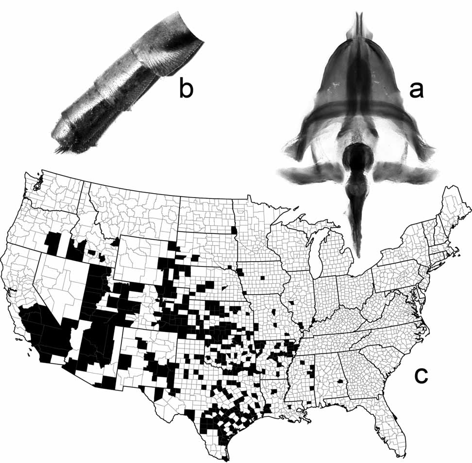
( FIGS 1 View FIGURE 1 , 3 View FIGURE 3 , 4 View FIGURE 4 )
Diogmites angustipennis Loew 1866: 23 View in CoL .
Diogmites symmachus Loew 1872: 66 View in CoL . New synonymy.
Deromyia pulchra Back 1909: 361 View in CoL (= Diogmites pulcher ). New synonymy. Diogmites grossus Bromley 1936: 236 View in CoL . New synonymy.
Diagnosis. Male 16.5–28.9 mm long (mean = 23.4 mm); female 15.2–29.9 mm long (mean = 24.2 mm). Average antennomere:scape ratios 1.0:1.5:3.6. Male wing 13.8–20.6 mm long (mean = 16.8 mm); female wing 10.0–20.1 mm long (mean = 16.9 mm). Phallus not bilobed ( Fig. 3 View FIGURE 3 a). Female abdominal tergites 1–4 or 1–5 and sternites 1–5 pollinose and opaque; tergites 5–8 or 6–8 and sternites 6–8 polished ( Fig. 3 View FIGURE 3 b).
Discussion. Diogmites angustipennis varies widely in size and color, but few specimens display the darkest pigmentation found among specimens of D. bilobatus sp. nov. There is a general tendency for specimens from more southern areas to be darker, but regional populations often display a wide range of coloration. Most specimens collected at College Station, Texas, have medium brown abdominal tergites, but a few have yellowish orange tergites. On the other hand, most specimens collected in Sedgwick County, Kansas, and Woodbury County, Iowa, have yellowish orange abdominal tergites, but a few have medium brown tergites. Specimens from Rooks County, Kansas, all collected 9 August 1912 at 1775 feet elevation, range from yellowish orange to nearly black. Of the 83 males collected in Garden Grove, Orange County, California in August and September, 1941, 41 specimens have black dorsal longitudinal thoracic stripes. Most females also have black thoracic stripes, but a few show the more typical pattern and lack dark thoracic markings.
There is also a wide size range, even within the same population. The Sedgwick County females range from 20 mm long to 28 mm long. The Rooks County females range in length from 22 to 29 mm. Garden Grove males range from 20 to 28 mm long, and females from the same locality range from 26 to 32 mm long.
Females usually have tergites 6–8 and the corresponding sternites completely glabrous. In some individuals, especially those that fit the descriptions of Diogmites grossus or D. pulcher , tergite 5 also is largely glabrous, except for the lateral edges, but sternite 5 is always pollinose and dull. Both ovipositor types can often be found in the same population. At Lamar, Prowers County, Colorado, the type locality of Diogmites grossus , some females have dull and pollinose tergite 5 while others have a largely glabrous tergite 5. Most of the seven specimens that I have seen from Masters, Weld County, Colorado have a glabrous tergite 5, but in one specimen this tergite is clearly pollinose dorsally. Most females from Utah that I have seen have a largely glabrous tergite 5, but most specimens from California have a pollinose tergite 5. Many of the specimens from the large series collected at Garden Grove, Orange County, California in August and September, 1941, have dark mesonotal stripes and wings yellowed around the veins, and they key to D. pulcher in Bromley’s (1936) key. Three-quarters of the females have the fifth tergite pollinose, but one quarter have the fifth tergite glabrous. Glabrous fifth tergites are found in some specimens from the following states: Arizona, California, Colorado, Idaho, Kansas, Nebraska, New Mexico, Oklahoma, Oregon, Texas, Utah, and Wyoming.
However, there is a tendency toward regional consistency in both size and color. Specimens collected from agricultural lands, mostly cotton and soybean fields, in Conway County, Arkansas, in the late 1950s and early 1960s are shorter (19.1±3.0 mm; n = 27) than the average 23.8 mm length. They tend to be lightly pigmented, and their abdomens appear bright golden orange. Specimens collected from vineyards in northwest Arkansas in 2003 are much larger (25.9±2.6 mm; n = 31), and their abdomens are a fairly dark brown. It is tempting to speculate that prey availability and edaphic factors to which the soil-dwelling larvae are exposed, such as frequency of disturbance and insecticide concentrations, might account at least in part for the observed variation.
The known range of D. angustipennis in North America north of Mexico extends from southeastern North Dakota to southeastern Alabama in the east, and from southeastern Oregon to southern California in the west ( Fig. 3 View FIGURE 3 c). This species also occurs in northern Mexico. Labels on museum specimens indicate that adults are active from April and May to late November in the southern part of the species’ range. However, most museum specimens bear labels dated July, August, or September. Specimens have been collected at College Station, Brazos County, Texas, from early April to late October. In Colorado, they have been collected from mid July to late September.
In Platte County, southeastern Wyoming, Lavigne and Holland (1969) found that Diogmites angustipennis is a common denizen of the open plains, often found in rank and shrubby vegetation along intermittent stream beds. It is a strong flier, making flights up to 50 to 100 yards, often landing on tall vegetation. It tends to forage from the ground in the morning before the soil becomes too warm. Later in the day it forages from horizontal branches of various shrubs. These asilids usually take their prey in the air, although they will sometimes capture prey crawling on the ground or on vegetation. They take many kinds of prey in at least seven insect orders, 29 families, and 51 genera. However, they seem to have a clear preference for relatively large Hymenoptera . Out of 97 prey species recorded by Lavigne and Holland (1969), 63% were Hymenoptera and 25% were Diptera .
Nearby, in Weld County, Colorado, O’Neill and Bjostad (1987) found that Diogmites angustipennis preys on males of the bee Nomia nevadensis bakeri Cockerell ( Hymenoptera : Halictidae ). The male bees congregate in large numbers and compete heavily for emerging virgin females. In their zeal to find and guard mates they become conspicuous targets for predation by D. angustipennis .
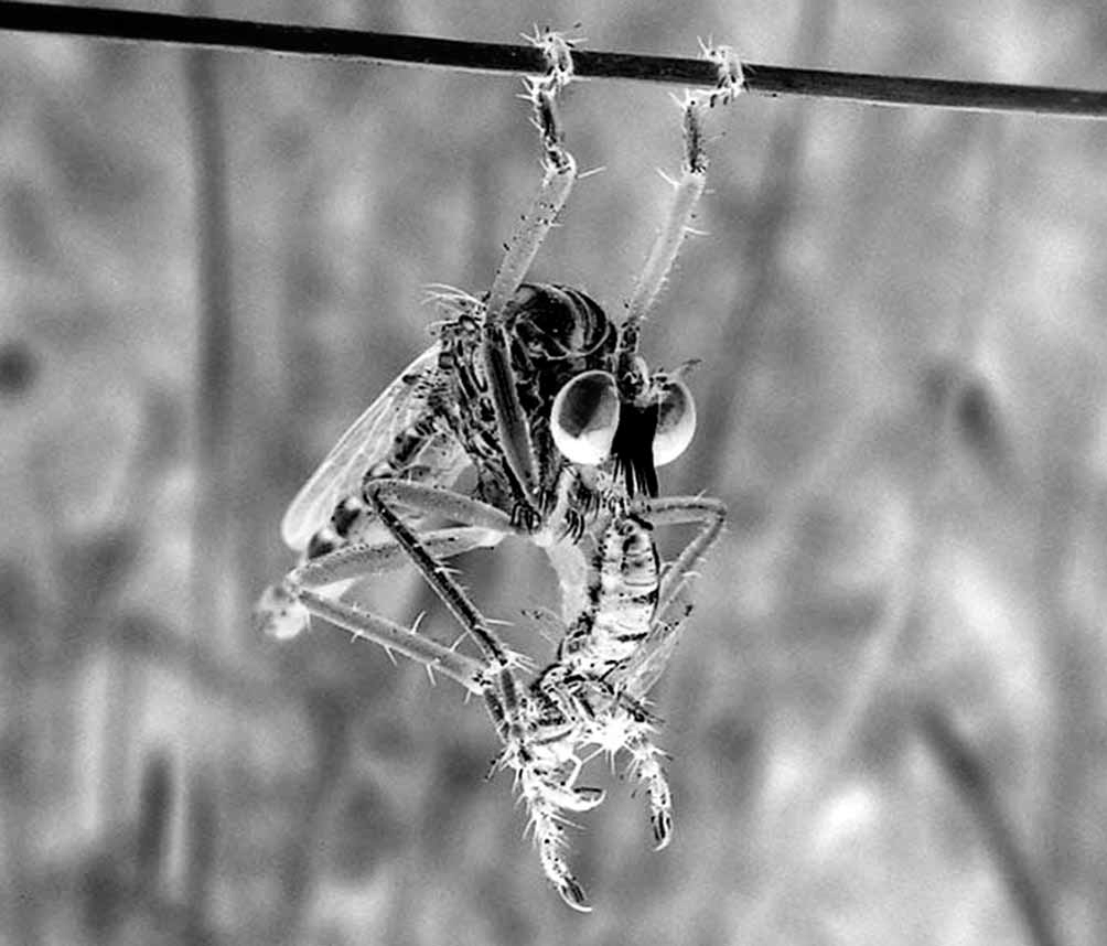
Captured prey is enclosed within the fly’s spiny legs. The asilid carries it to a suitable perch, from which it hangs by one or both front tarsi ( Fig. 4 View FIGURE 4 ), earning it the nickname “hanging thief. Once the prey is manipulated into a suitable position, the predator impales it with its proboscis, usually through the membranous cervix. Prey is usually held from above and behind, oriented facing the same direction as the fly. This helps the asilids to avoid the stings of aculeate Hymenoptera ( Lavigne and Holland 1969).
In the Wyoming study, most mating activity occurred during the middle of the day. On warm days, large numbers of males held their front tarsi high and out in front while flying slowly from shrub to shrub with their wings producing a loud buzz. When a male found another individual feeding or foraging, he began a courtship hover about one foot from his potential mate, with front legs held above the thorax. When the other individual was a receptive female, the couple mated in an end-to-end position for a period of several hours.
Females oviposited in the morning. They dragged their ovipositors over the soil and thrust them from side to side, evidently sensing the soil texture. At appropriate sites, they pushed their ovipositors into the soil and jerked the terminal spines upward from time to time, displacing the soil as the abdomen sank down to the first segment. Eggs were deposited side by side in the soil in clutches of 5– 14 eggs each.
Bromley (1934) discussed the biology of D. angustipennis and D. symmachus in Texas. It is possible that some of the observations he relates were actually made on D. bilobatus , which occurs widely in Texas. He found the flies to be common in cotton fields, pastures, and waste lands, especially in areas of alluvial and sandy soils. They flew with a high-pitched buzz, darting among plants and preying on honey bees, wasps, and other insects. They could be pests around bee hives. They were also cannibalistic, the females often killing and devouring approaching males. Out of 113 prey items recorded in eight orders, 60% were Hymenoptera and 24% were Diptera , mostly Asilidae . These prey data are nearly identical to those recorded in the Wyoming study.
Some museum specimens that I examined have the following prey items pinned beneath them:
Orthoptera : Acrididae , Texas, Zavala County, Nueces River, 4 mi. E La Pryor, 9.IX.1972 (SEMC).
Hemiptera : Coreidae , Texas, McLennan County, 9.VII.1945 (TAMU). Coreidae , Leptoglossus sp., Texas, Montague County, Forestburg, 26.IX.1941 (USNM). Reduviidae , Texas, McLennan County, 17.VI.1934 (CAS). Reduviidae , Sinea sp., Wyoming, Crook County, Devils Tower National Monument, 16–18.VIII.1983 (ESUW).
Coleoptera : Carabidae , Cicindela , Texas, McLennan County, 9.VII.1933 (TAMU). Chrysomelidae , Texas, Montague County, Forestburg, 25.IX.1941 (USNM). Scarabaeidae , Texas, McLennan County, 20.VI.1934 (FSCA). Scarabaeidae , Texas, Victoria County, 15 mi. N Victoria, 28IX.1965 (UCDC).
Diptera : Asilidae , Efferia sp., Wyoming, Platte County, Wheatland, 24.VIII.1964 (ESUW). Asilidae , Machimus sp., Colorado, Douglas County, 28.VIII.1969 (CSUC). Asilidae , Prolepsis tristis (Walker) , Texas, Brazos County, College Station, 30.IX.1932 (USNM). Asilidae , Prolepsis tristis (Walker) , Texas, Brazos County, College Station, 23.IX.1933 (USNM). Asilidae , Promachus bastardii (Macquart) , Texas, Brazos County, College Station, 21.VI.1932 (USNM). Asilidae , Stichopogon trifasciatus (Say) , Texas, Dickens County, Spur, 11.IX.1932 (USNM). Bombyliidae , Texas, Montague County, Forestburg, 26.IX.1941 (USNM). Muscidae , Wyoming, Platte County, Wheatland, 16.IX.1973 (ESUW). Stratiomyidae , Hoplitimyia sp., Texas, Brazos County, College Station, 27.VIII.1933 (TAMU). Stratiomyidae , Stratiomys meigenii (Wiedemann) , McLennan County, Texas, Valley Mills, 24.VII.1932 (USNM).
Lepidoptera : Texas, Brazos County, College Station, 23.IX.1933 (CAS).
Hymenoptera : Andrenidae , California, Fresno County, Kingsburg, 6.VIII.1952 (UCDC). Andrenidae , Utah, Millard County, Delta, 30.VII.1949 (EMUS). Apidae , Apis mellifera Linnaeus , Colorado, Boulder County, Boulder, 25.VII (AMNH). Apidae , Apis mellifera Linnaeus , Kansas, Cherokee County, 5 km E Crestline, 2.VIII.1985 (SEMC). Apidae , Apis mellifera Linnaeus , Kansas, Riley County, Manhattan, September (KSUC). Apidae , Apis mellifera Linnaeus , Texas, Bexar County, 2.X.1931 (CAS). Apidae , Apis mellifera Linnaeus , Texas, Bexar County, 11.IX.1931 (TAMU). Apidae , Apis mellifera Linnaeus , Texas, Bexar County, 8.X.1931 (CAS). Apidae , Apis mellifera Linnaeus , Texas, Lavaca County, 10 mi. N Hallettsville, 28.IX.1965 (UCDC). Apidae , Apis mellifera Linnaeus , Texas, Uvalde County, Nueces River, Highway 55, S of Campwood, 13.VI.1992 (CSUC). Apidae , Apis mellifera Linnaeus , Wyoming, Crook County, Devils Tower National Monument, 16–18 August 1983 (ESUW). Apidae , Bombus sp. Texas, Bexar County, 2.X.1931 (CAS). Pompilidae , Oklahoma, Comanche Co., Punch Bowl Road, 2 mil. E Letra, 1.VII.2003 (CSUC). Pompilidae , Texas, Brazos County, College Station, 4.VI.1933 (TAMU). Pompilidae , Texas, McLennan County, 16.VII.1933 (TAMU). Pompilidae , Wyoming, Platte County, Glendo Road, 13 mi. W Glendo, 26.VII.1998 (CSUC). Scoliidae , Scolia sp., Colorado, Las Animas County, Iron Canyon, Steinman’s Ranch., Purgatoire River, 14.VII.1991. Sphecidae , Ammophila sp., Colorado, Las Animas County, Iron Canyon, Steinman’s Ranch., Purgatoire River, 14.VII.1991 (CSUC). Sphecidae , Ammophila sp., Utah, Pine Valley, VIII.1950 (USNM). Sphecidae , Sceliphron caementaria (Drury) , Kansas, Riley County, Manhattan, 26.VII.1955 (KSUC). Sphecidae , Sceliphron caementaria (Drury) , Texas, Brazos County, College Station, 23.VIII.1932 (USNM). Sphecidae , Tachytes sp., Oklahoma, Comanche County, Fort Sill, Quanah Range, 0.5 mi. E Falcon Gate, 19.IX.2003. Sphecidae , Arizona, Yavapai County, Oak Creek Canyon, 15.VIII.1938 (USNM). Sphecidae , Texas, McLennan County, 8.VII.1934 (FSCA). Sphecidae , Utah, Westside Lake, 20.VIII.1950 (USNM). Tiphiidae , Myzinum sp., Louisiana, Beauregard Parish, 16.VIII.1928 (SEMC). Tiphiidae , Myzinum sp., Oklahoma, Comanche County, Fort Sill, West Range, short grass, 13–14 September 2002. Tiphiidae , Texas, Brazos County, College Station, 19.VI.1932 (USNM). Tiphiidae , Texas, Lavaca County, 15 mi. S Hallettsville, 28.IX.1965 (UCDC). Vespidae , Eumenes sp., Kansas, Riley County, Manhattan, 5.IX.1931 (KSUC). Vespidae , California, Tulare County, Vislia, 23.VIII.1950 (UCDC). Vespidae , Kansas, Cherokee County, 5 km. E Crestline, 2.VIII.1985 (SEMC). Vespidae , Oklahoma, Comanche County, Fort Sill, East Range, 10.VIII.2002. Vespidae , Texas, Bexar County, 2.X.1931 (CAS). Vespidae , Texas, Brazos County, College Station, 5.VI.1932 (TAMU). Vespidae , Texas, Brazos County, College Station, 24.X.1945 (TAMU).
Type material examined. Diogmites angustipennis was originally described from two female specimens collected in Kansas. I have examined both specimens, which are in the MCZ collection, and I hereby designate one of them as lectotype for clarification and to ensure stabilization in nomenclature. That specimen bears the following labels: ‘Kansas’; ‘Loew coll.’; ‘ Type 12820’; ‘ angustipennis ’; ‘ Jan.–July 2003 MCZ image database’; ‘ Lectotype, Diogmites angustipennis Loew, 1866 , designated by J. K. Barnes 2004’. The paralectotype ( MCZ) bears the following labels: ‘Mat’; ‘Loew coll.’; ‘ Type 12820’. “Mat probably refers to the collector, Matamoras, cited in the original description.
Diogmites symmachus View in CoL was originally described from a male and a female specimen, both collected in Texas. I have examined both specimens, which are in the MCZ collection, and I hereby designate the male specimen as lectotype for clarification and to ensure stabilization in nomenclature. That specimen bears the following labels: ‘Texas Lafr.’; ‘Loew coll.’; ‘ Type 12826’; ‘ symmachus Lw. Cent. View in CoL X’; ‘ Jan.–July 2003 MCZ image database’; ‘ Lectotype Diogmites symmachus Loew, 1872 View in CoL , designated by J. K. Barnes 2004’. The female paralectotype (MCZ) bears the following labels: ‘Texas Lafr.’; ‘Loew coll.’; ‘ Type 12826’. “Lafr. might be a flawed reference to the collector of the specimens, Gustaf Wilhelm Belfrage, who was cited in the original description. Belfrage was a Swedish nobleman who spent the last 16 years of his life, 1867–1882, collecting insects in Texas, mostly in Bosque and McLennan Counties and surrounding areas of central Texas. He sold collections to many museums in the United States and Europe ( Geiser 1948).
The D. angustipennis View in CoL female lectotype is 21.6 mm long, and its wing is 16.4 mm long. The D. symmachus View in CoL male lectotype is 19.3 mm long, and its wing is 13.5 mm long. The D. angustipennis View in CoL lectotype has a brown mesonotum and brown abdominal tergites, whereas the D. symmachus View in CoL lectotype has a more orange or ochreous mesonotum and abdomen. In both the D. angustipennis View in CoL lectotype and the D. symmachus View in CoL female paralectotype, abdominal tergites 1–5 and the corresponding sternites are dull and pollinose, whereas tergites 6–8 and the corresponding sternites are glabrous except for the lightly pollinose extreme lateral edges of tergite 6.
Diogmites pulcher was originally described from a single male collected in Los Angeles County, California. This holotype (USNM) bears the following labels: ‘ Type No. 11027 U. S. N. M.’; ‘ Type D. pulchra’; ‘ Deromyia pulchra Back. ’.
Diogmites grossus was originally described from a male holotype, three male paratypes, 12 female paratypes, and 19 paratypes of unspecified sex. I have examined the holotype and eight paratypes. The holotype (USNM) bears the following labels: ‘COLO. Prower Co., Lamar, 279, Aug. 25, 1925, F. M. Gaige’; ‘ Deromyia bigoti Bellardi, Det. C. T. Greene 1928’; ‘ Holotype ɗ, Diogmites grossus Bromley’; ‘SWBromley Collection 1955’.
The D. pulcher holotype is 26.3 mm long, and it wing is 17.6 mm long. It is a darkly pigmented specimen. The mesonotum bears three dark brown vittae. The middle vitta is divided longitudinally and reaches to the pronotum. The abdominal tergites are dark brown dorsally, and the otherwise hyaline wings are distinctly yellowed around the veins. The lateral flanges of the ventral aedeagal channel are not well developed. The D. grossus holotype is 29.8 mm long, and its wing is 19.0 mm long. The mesonotum lacks distinct vittae and the abdominal tergites are brown, about the same color as in the D. angustipennis lectotype. The lateral flanges of the ventral aedeagal channel are not well developed. The hyaline wings have some light yellowing around the veins. There is no pale bloom or sheen that distinctly sets this specimen apart from the D. angustipennis lectotype. Diogmites grossus paratypes in the USNM collection from Lamar, Prowers County, Colorado; Parma, Canyon County, Idaho; and Moab, Grand County, Utah have the typical D. angustipennis abdominal vestiture, with tergites 1–5 and the corresponding sternites dull and pollinose and tergites 6–8 and the corresponding sternites glabrous. One paratype from near Midvale, Salt Lake County, Utah, has abdominal tergites 1–4 dull and pollinose. Tergite 5 is glabrous dorsally and pollinose laterally. Sternite 5 is pollinose. Tergites and sternites 6–8 are glabrous.
Other material examined. UNITED STATES. ALABAMA: Macon County, Tuskegee, 22.VII.1930, Ψ ( SEMC).
ARIZONA: Apache County, Horseshoe Cienega, 12 mi. E McNairy on Rt. 73, 30.VII.1962, ɗ ( UAIC). Cochise County, Willcox, 1.VIII.1909, ɗ ( USNM); 14.VIII.1958, 12ɗ ( UCDC, UCR); 30.VIII.1958, ɗ ( UCDC); 27.VIII.1959, 14ɗ ( EMEC); 31.VIII.1959, 20ɗ ( EMEC); 1 mi. S Willcox, 23.VIII.1961, 2ɗ ( UAIC); 3 mi. SE Willcox, 31.VIII.1959, ɗ ( AMNH). Coconino County, 27 mi. N Cameron, 30.VIII.1967, Ψ ( UCR); Flagstaff, 5.VIII.1973, ɗ ( UCR); Grand Canyon, 11.IX.1932, ɗ ( EMUS); "General Springs", 6200', 28.VIII.1935, Ψ ( USNM); Oak Creek Canyon, 15.VIII.1938, ɗ ( USNM); 13.VIII.1958, ɗ ( EMEC); 1.VIII.1962, ɗ ( BYU); 4.VIII.1982, Ψ ( UCR); 10.VIII.1991, ɗ ( UCDC); 6000', August, 3ɗ ( AMNH, OSU); Oak Creek Canyon, Pine Flat Campground, 22.VIII.1967, ɗ ( UCR); West Fork of Oak Creek, 30.VIII.1985, 2ɗ ( BYU). Gila County, Carrizo, 1.IX.1986, ɗ, Ψ ( EMUS); 5 mi. N Payson, East Verde Park, 12.IX.1969, ɗ ( UCR); Sierra Ancha Mountains, August, Ψ ( USNM); Sierra Ancha Mountains, 4.IX.1932, ɗ ( CAS). Maricopa County, Granite Reef, 12.IX.1936, ɗ, Ψ ( AMNH); Granite Reef Dam, 29.VIII.1964, ɗ ( EMEC); Granite Reef Dam, 16.IX.1968, ɗ, Ψ ( CAS); Phoenix, August, ɗ, Ψ ( USNM); Phoenix, 1929, ɗ ( WSU); Tempe, 17.VII.1962, Ψ ( EMEC); ASU, Tempe, 12.IX.1973, Ψ ( CAS). Navajo County, Shumway, 1.IX.1959, 2Ψ ( CAS); White Mountains, September, 2ɗ ( AMNH, CAS). Santa Cruz County, Sonoita, 4000', 10.X.1930, Ψ ( USNM). Yavapai County, near Del Rio Verde River, 18.IX.1929, ɗ ( CAS); Oak Creek, Red Rock Crossing, 30.VIII.1985, Ψ ( BYU). Yuma County, Yuma, VIII.1936 ( AMNH); Yuma, alfalfa, 6.VII.1925, ɗ ( CAS); 4.IX.1925, Ψ ( CAS); 3.IX.1926, ɗ, Ψ ( CAS).
ARKANSAS: Benton County, Lowell, Bishop Vineyard, Malaise trap, 29.VII.2003, ɗ (UAAM); 14.VIII.2003, 8ɗ (UAAM). Bradley County, cotton, 8.VII.1959, ɗ, Ψ (UAAM). Carroll County, Roberts Farm, 29.VII.2003, Ψ (UAAM). Columbia County, pond, 1989, Ψ (UAAM). Conway County, 10.VIII.1961, ɗ (CAS); 28.VIII.1961, Ψ (CAS); 8.IX.1961, Ψ (CAS); 15.VII.1964, Ψ (UAAM); alfalfa, 10.VIII.1961, 3Ψ (UAAM); 9.IX.1961, ɗ, Ψ (UAAM); corn, 12.VII.1959, Ψ (UAAM); 9.IX.1961, ɗ, 2Ψ (UAAM); 27.VII.1964, Ψ (UAAM); cotton, 14.VII.1959, 2Ψ (UAAM); 24–25.VIII.1959, ɗ, 2Ψ (UAAM); 2.IX.1959, 2ɗ, 13Ψ (UAAM, USNM); 6.VI.1960, Ψ (UAAM); 14–19.VII.1960, ɗ, 4Ψ (UAAM); 26.VIII.1960, 6Ψ (UAAM); 6.IX.1960, 2ɗ, 2Ψ (UAAM); 25.VIII.1961, Ψ (UAAM); 11.IX.1961, Ψ (UAAM); 5.VII.1963, ɗ (UAAM); sorghum, 12.VII.1959, ɗ (UAAM); soybeans, 18.VII.1960, 3ɗ (UAAM); 6.VII.1961, ɗ (UAAM); 10.VII.1961, ɗ, 3Ψ (UAAM); 25.VII.1961, 3ɗ, 6Ψ (UAAM); 26.VII.1961, Ψ (UAAM); 1.VIII.1961, ɗ, 3Ψ (UAAM); 10.VIII.1961, 4Ψ (UAAM); 16.VIII.1961, ɗ, Ψ (UAAM); 20.VIII.1961, 3ɗ (UAAM); 24– 31. VIII.1961, 5 ɗ, 17Ψ (UAAM);5–11. IX.1961, 2 ɗ, 9Ψ (UAAM); 20.X.1961, ɗ (UAAM); 10.VIII.2003, ɗ (UAAM); weeds, 17.VII.1959, ɗ (UAAM); 14.VII.1960, ɗ (UAAM); 26.VIII.1960, ɗ (UAAM); 6.IX.1960, ɗ (UAAM); 24.VII.1961, 2Ψ (UAAM); 30.VIII.1961, Ψ (UAAM); 11.IX.1961, ɗ (UAAM). Craighead County, 10.VIII.1967, Ψ (UAAM); 25.VIII.1984, 2Ψ (ASUC); 13.IX.1993, Ψ (ASUC); Bono Bog, 11– 21. VII.2003, 3 ɗ (UAAM); Hatchie Coon, 24.VIII.2003, Ψ (UAAM); Jonesboro, bypass, abandoned field, 8.VII.1979, ɗ (UAAM); 7–9. VIII.1979, 2 ɗ, Ψ (UAAM); Lester Levee, 23.VII.2003, ɗ (UAAM). Cross County, 14.X.1995, Ψ (ASUC); Village Creek State Park, 9.IX.2003, Ψ (UAAM). Faulkner County, Camp Robinson Wildlife Development Area, 12–17. VII.2003, 2 ɗ, 2Ψ (UAAM); 26.VIII.2003, Ψ (UAAM). Franklin County, 4.VII.2003, ɗ (UAAM). Greene County, Crowley's Ridge State Park, 10.VII.2003, 2ɗ (UAAM). Hempstead County, cotton, 19–29. VIII.1959, 2 ɗ, 8Ψ (UAAM); 15.IX.1959, Ψ (UAAM); 5– 6.IX.1960, ɗ, 35Ψ (UAAM); field peas, 29.VIII.1959, Ψ (UAAM); Hope, 22.IX, Ψ (UCDC). Izard County, 15.X.1986, Ψ (ASUC). Jefferson County, cotton, 14.VII.1959, Ψ (UAAM). Lawrence County, 20.IX.1983, 3Ψ (ASUC); 4.IX.1988, Ψ (ASUC); Imboden, ɗ, 4Ψ (CSUC, OSEC). Little River County, weeds, 4.VII.1961, ɗ (UAAM). Madison County, Hindsville, Gay Vineyard, Malaise trap, 26–29. VII.2003, 10 ɗ, Ψ (UAAM); 14.VIII.2003, 10ɗ, 6Ψ (UAAM). Mississippi County, Johnson grass, 12.VII.1967, ɗ (UAAM); willow, 29.VII.1966, ɗ (UAAM); Mississippi River, near Armorel, 30.VIII.2003, ɗ, 3Ψ (UAAM). Perry County, Toad Suck beach, 16–19.VIII.2003, ɗ, 3Ψ (UAAM). Poinsett County, 21.X.1992, Ψ (ASUC). Pulaski County, grass, 15.XI.1999, Ψ (UAAM). Randolph County, 26.IX.1986, Ψ (ASUC); Hwy 63 & Eleven Point River, 5.IX.2003, 2ɗ, 2Ψ (UAAM). Sebastian County, 15.IX.1926, 3Ψ (OSEC, UAAM). St. Francis County, 5.IX.1926, 2Ψ (OSEC, UAAM). Stone County, above Gunner Pool, 5.VIII.2003, Ψ (UAAM). Washington County, 9.IX.1953, Ψ (USNM); IX.1955, Ψ (UAAM); 3.IX.1959, Ψ (UAAM); X.1959, Ψ (UAAM); IX.1960, ɗ (UAAM); 2.IX.1960, Ψ (UAAM); 12.IX.1960, Ψ (UAAM); 8.X.1960, Ψ (UAAM); 7.IX.1965, ɗ (CAS); 26.VII.1969, Ψ (UAAM); light trap, 25.VII.1965, ɗ (UAAM); crimson clover, 22.VIII, 2Ψ (UAAM); crimson clover, 24.VIII, ɗ (UAAM); crimson clover, 28.VIII.1959, Ψ (UAAM); eggplant, 17.VIII.1959, Ψ (UAAM); weeds, X.1959, ɗ (UAAM); C. Creek, grass and weed swamp, 20.VIII.1932, 2Ψ (UAAM); Clear Creek, 4.IX.1954, Ψ (UAAM); Cove Creek, meadow, 8.IX.1962, Ψ (UAAM); Fayetteville, University of Arkansas farm, 18.IX.2002, ɗ (UAAM); 5.VII.2003, ɗ (UAAM); 8.VIII.2003, ɗ (UAAM). White County, Bald Knob, abandoned vineyard, Malaise trap, 12.VIII.2003, Ψ (UAAM); Bald Knob NWR, 23.VIII.2003, Ψ (UAAM); Judsonia, Gillam Vineyard, Malaise trap, 12.VIII.2003, Ψ (UAAM); Searcy, Smith Vineyard, Malaise trap, 15.VII.2003, ɗ (UAAM); 31.VII.2003, ɗ (UAAM); 12.VIII.2003, ɗ (UAAM). Woodruff County, 12.IX.1983, Ψ (ASUC).
CALIFORNIA: Fresno County, Clovis, 7.X.1951, Ψ (CAS); Fresno, IX.1929, 2 male, Ψ (EMEC); 4.IX.1935, ɗ (AMNH); 23.X.1954, Ψ (CAS); 30.IX.1955, ɗ (CAS); 1.X.1955, ɗ (CAS); 20.IX.1958, ɗ (CAS); 8 mi. NW Kerman, 10.VIII.1961, ɗ (CAS); Kerman, 10.VIII.1973, Ψ (EMEC); Kingsburg, 6– 7.VIII.1952, ɗ (UCDC); Reedley, 20.VIII.1950, ɗ (UCDC); Reedley, 11.IX.1952, Ψ (UCDC). Inyo County, Lone Pine , 7.IX.1935, 2ɗ, 2Ψ (USNM). Kern County, 28.VIII.1958, Ψ (UCDC); button willow, 6.VIII.1955, Ψ (EMEC); near Hwy 99, 1.7 mi. S of Hwy 223, 8.IX.1990, Ψ (UCR); 29.IX.1990, ɗ (UCR); 22.IX.1998, ɗ, Ψ (UCR); 3.5 mi. S of Hwy 223, 0.5 mi. E Wible Rd., 15.IX.1998, Ψ (UCR); Bakersfield, 24.IX.1965, Ψ (EMEC); Shafter, 14.IX.1952, ɗ, 2Ψ (CAS). Kings County, Lemoore, 6.VIII.1932, 2ɗ, 4Ψ (CAS, EMEC). Los Angeles County, Bellflower, 1.X.1956, Ψ (CAS); Huntington Park, 1.IX.1937, ɗ (CAS); Los Angeles, VII.1961, ɗ (UCR); Norwalk, on flowers, 8.VIII.1949, Ψ (EMEC); Pasadena, 5.IX.1963, Ψ (UCR). Orange County, Anaheim, 26.VIII.1958, ɗ (BYU); Garden Grove, 6–22. VIII.1941, 18 ɗ, 8Ψ (CAS); 2–3.IX.1941, 54ɗ, 9Ψ (CAS, EMUS); 22–23. IX.1941, 11 ɗ, Ψ (CAS); 9.VIII.1949, Ψ (UCR). Riverside County, Banning, 26.VIII.1909, ɗ (USNM); Blythe, 22.VIII.1966, Ψ (NMSB); Ripley, sweeping alfalfa, 12.VIII.1946, 2Ψ (EMEC); Riverside, 17.IX.1933, Ψ (UCR); 14.X.1933, Ψ (CAS); 20.IX.1962, ɗ (UCR). San Bernadino County, 3 mi. S Highland, 5.VIII.1957, ɗ (EMEC); Needles, 22.IX.1909, Ψ (USNM); Redlands, 1913, ɗ, Ψ (EMEC); San Bernadino, [no date], 2ɗ (CAS). San Diego County, San Ysidro, 1.IX.1948, ɗ (UCR). Tulare County, Lindsay, 6.IX.1932, ɗ, Ψ (UCR); Visalia, 9.IX.1945, Ψ (CAS); 23.VIII.1950, Ψ (UCDC).
COLORADO: Alamosa County, Box Canyon, near Alamosa, 2.IX.1921, Ψ (CAS). Arapahoe County, Roxborough State Park, VI.1993, ɗ, 2Ψ (CSUC). Baca County, Rd. 18, 0.8 mi. N of Rd G, 12.VII.1991, Ψ (CSUC); S Lamport, 2.VIII.1933, 2Ψ (USNM); Picture Canyon picnic area, 16.VII.1992, ɗ, 4Ψ (CSUC); Sand Canyon, 13.VII.1991, Ψ (CSUC). Bent County, Rd CC, 24.VIII.1996, Ψ (CSUC); 2.5 mi. S Caddoa, sand dunes along Caddoa Ck., 11.VII.1991, ɗ, 4Ψ (CSUC); Hasty, 17.VII.1974, 2ɗ (CSUC); John Marin Reservoir, GG Road (Caddoa Cr.), 26.VIII.2001, ɗ (CSUC). Boulder County, 12.IX.1926, Ψ (CSUC); 7.VIII.1934, 2ɗ (USNM); Boulder, 25.VII, ɗ (AMNH); 9.VIII, ɗ (USNM); 13.VIII, ɗ (USNM); 7.VIII.1906, Ψ (AMNH); 28.VIII.1907, Ψ (WSU); 2.VIII.1932, ɗ, Ψ (CSUC); 5.VIII.1932, ɗ (WSU); 20.VII.1933, ɗ, 2Ψ (CAS, CUIC); 30.VIII.1933, ɗ (CUIC); 27.VII.1934, 4ɗ, 2Ψ (CSUC, WSU); 3.VIII.1934, ɗ (CSUC); Boulder, Gregroy Canyon, about 5600', 12.VIII.1922, ɗ (USNM); Marshall, 13.VIII.1964, Ψ (UAIC); White Rocks, 13.VIII, Ψ (CSUC); White Rock, near Boulder, about 4003’N, 10508’W, about 5100 ft., 13.VIII.1919, ɗ (AMNH). Clear Creek County, 3.VIII.1898, ɗ, Ψ (OSU). Crowley County, Crowley, 1.IX.1932, Ψ (CAS); Ordway, 6.VIII.1937, 3Ψ (CSUC, WSU). Douglas County, Kinny Creek, 3.VIII.1994, Ψ (CSUC); mouth Varic Cyu, 28.VIII.1969, ɗ (CSUC). El Paso County, Colorado Springs, on ground, 31.VII.1964, ɗ (WFBM). Freemont County, 6.5 km NE Canon City, 1740 m, 28.VII.1992, 3Ψ (CMNH). Huerfano County, 6000', 14.VIII, ɗ, Ψ (KSUC); La Veta, 5.VIII.1933, ɗ (CSUC); Walsenburg, 3–6. VIII.1925, 2 ɗ, 3Ψ (UMMZ). Jefferson County, 24.VII.1961, ɗ (KSUC); Golden, 9.VIII.1898, ɗ (OSU); 18.VIII.1938, Ψ (CAS); Morrison, 13.VIII.1898, ɗ, 2Ψ (OSU). Kiowa County, N Eads, 20.VII.1933, ɗ (CSUC). Kit Carson County, S Burlington, 27.VII.1933, ɗ (CSUC). Larimer County, Bellvue Fishery, 27.VIII.2001, Ψ (CSUC); Dixon Res., 2.VIII.1993, Ψ (CSUC). Fort Collins, 14.VII.1900, Ψ (CAS); 23.IX.1915, ɗ (CSUC); 31.VII.1936, Ψ (CSUC); 7.VIII.1936, ɗ (CSUC); 15.VII.1959, ɗ (UCR); 30.IX.1967, ɗ (CSUC); 19.VIII.1977, Ψ (CSUC); mixed grass prairie, 31.VII.1993, ɗ (ESUW); Horsetooth, 30.VIII.1991, Ψ (CSUC); Lory State Park, 29.VII.1994, 2ɗ (CSUC); Masonville, 5.IX.1933, ɗ, Ψ (CSUC); Pineridge Open Space, 30.VIII.1995, Ψ (CSUC). Las Animas County, Iron Canyon, Steinman's Ranch (Rourke Ranch), Purgatoire R., 14.VII.1991, 13ɗ, 15Ψ (BYU, CSUC). Lincoln County, Genoa, 15.VIII.1940, Ψ (KSUC). Mesa County, 2 mi NE Gateway, 9.VIII.1981, ɗ (CSUC). Moffat County, Brown's Park, 3.VIII.1983, ɗ (ESUW). Montezuma County, McElmo Canyon, Anazasi SRMA, G Road, 25.VIII.1992, Ψ (CSUC). Montrose County, 18 mi. SE Gateway, 19.VIII.1963, Ψ (KSUC). Morgan County, Fort Morgan, 5.VIII.1960, 2ɗ (FSCA); Muir Springs, 3.IX.1990, Ψ (CSUC). Otero County, Co. Rt. 109, MP 37, 11.VIII.1990, 7Ψ (CSUC); Co. Rt. 109, MP 42, 11.VIII.1990, ɗ (CSUC); La Junta, about 3759’N, 10331’W, about 4100 ft. alt., 12.VIII.1920, 2ɗ (AMNH);Vogel Canyon Picnic Area, 3 mi. off Rt. 109, 17.VII.1992, Ψ (CSUC); Vogel Canyon, 14.VII.1993, ɗ, Ψ (CSUC); 13.VIII.1993, Ψ (CSUC); Vogel Canyon, 18 mi. S La Junta, 1200 m, 27.VII.1994, ɗ (CSUC). Prowers County, Lamar, 25–27.VIII.1925, ɗ, 6Ψ (USNM); Pueblo, 4.VIII.1938, ɗ (CSUC). Weld County, Co. Rd. 122, 5 mi. E of SR 85, 7.IX.1992, Ψ (CSUC); Deerfield, 29.VIII.1940, 2ɗ (KSUC); Greeley, 24.VIII.1930, ɗ (KSUC); Masters, 4300', 3.IX.1939, ɗ, 7Ψ (USNM); Roggen, 31.VIII.1938, 2ɗ (USNM, WIRC); Co. Rd. 386, 3 mi. N Roggen, 21.VIII.1990, ɗ (CSUC); Co. Rd. 386, N Roggen, sand dunes, 26.VIII.1990, 3ɗ, 2Ψ (CSUC). Yuma County, Wray, 3700', 17–19.VIII.1919, ɗ, Ψ (AMNH, USNM).
IDAHO: Canyon County, Parma, 12.VIII.1934, ɗ (USNM); 4.VIII.1939, ɗ (UCDC). Elmore County, Dietrich Butte, 31.VII.1968, ɗ (ESUW); 2 mi. NE Glens Ferry, 9.IX.1967, 4Ψ (ESUW); Mt. Home, 27.VIII.1967, Ψ (ESUW). Fremont County, St. Anthony, sand dunes, 9.IX.1967, Ψ (ESUW). Lincoln County, 5 mi. E Dietrich, 6.VIII.1065, 4ɗ (WFBM); 7 mi. W Shoshone, 1.VIII.1961, ɗ (WFBM). Owyhee County, Bruneau Dunes State Park, 28.VII.1989, 2ɗ (BYU); Sand Dunes Lake, 10.VIII.1966, 2ɗ (CAS, WFBM).
ILLINOIS: Hardin County, Elizabethtown, 5.IX.1924, Ψ (INHS). Jackson County, Grand Tower, 10.VII.1909, Ψ (INHS). Morgan County, Meredosia, sand, 17.VIII.1913, 4Ψ (INHS); Meredosia, 19– 22. VIII.1917, 3 ɗ (INHS). Union County, Anna, 9.VII.1883, 2ɗ (INHS).
INDIANA: Posey County, New Harmony, 16.VIII.1918, 2ɗ, 2Ψ (USNM).
IOWA: Fremont County, Waubonsie State Park, loess–hill prairie, 5.VIII.1969, ɗ (ISUI). Plymouth County, 0.3 mi. N Sioux City, 7.VIII.1971, ɗ (ISUI). Story County, Ames, 16.VII.1948, 2ɗ, Ψ (ISUI). Woodbury County, 3 mi. SE Holly Springs, 4214’N, 962’W, 30.VII.1967, 5ɗ, 3Ψ (ISUI); Sioux City, 17.VIII.1953, ɗ (ISUI).
KANSAS: Barber County, 1468', 1916, 9ɗ, 7Ψ (SEMC, USNM). Butler County, 1285', 1916, 3ɗ, 4Ψ (SEMC, UAAM). Cherokee County, 888', 1915, Ψ (SEMC); 5 km E Crestline, 2.VIII.1985, ɗ, 5Ψ (SEMC); Lawton, 15.VIII.1930, ɗ (KSUC). Clark County, 1950', 26.VIII.1911, ɗ, 4Ψ (OSEC, OSU). Clay County, Clay Center, 15.VIII.1979, Ψ (UCR); Morganville, 31.VII.1962, Ψ (UCR). Comanche County, 15.VII, ɗ (KSUC); 2089', 1916, 7ɗ, 4Ψ (SEMC). Douglas County, 20.VII.1956, ɗ (SEMC); Lawrence, 10.IX.1954, Ψ (EMUS). Elk County, 1008', 1916, ɗ, Ψ (SEMC, USNM). Ellis County, 2000 ft., 19.VII.1912, ɗ (OSU). Ellsworth County, 17.VII.1923, ɗ (SEMC). Finney County, 15.VIII.1939, Ψ (KSUC); Garden City, VIII.1895, 2 ɗ (OSU); Garden City, VIII.1956, Ψ (SEMC); 1 mi. SW Garden City, 5.VIII.1963, Ψ (KSUC). Geary County, Fort Riley, 20.VII.1913, Ψ (USNM). Graham County, 2130', 16.VIII.1912, 4ɗ, 2Ψ (FSCA, OSEC, OSU). Grant County, 2800', 27.VII.1911, Ψ (OSEC). Gray County, 9–15. VII.1917, 2 Ψ (SEMC). Harper County, 3.VIII.1937, 2ɗ (KSUC); 1417', 1916, 10ɗ, 9Ψ (SEMC, USNM). Harvey County, 21– 27. VIII.1917, 9 ɗ, 7Ψ (SEMC). Kingman County, 1516', 1916, 7ɗ, 8Ψ (SEMC). Kiowa County, 2250', 5.VII.1911, 2Ψ, 2ɗ (FSCA, OSEC, OSU). Labette County, 899', 2ɗ (SEMC). Lincoln County, Shady Bend, 25.VIII.1962, Ψ (FSCA). Logan County, ɗ (SEMC). Meade County, 14.VIII.1945, 2ɗ (SEMC). Mitchell County, 25.VIII, Ψ (KSUC). Morton County, 2800', 5.VIII.1911, ɗ, 2Ψ (OSEC, OSU). Ness County, 2260', 7.VII.1912, ɗ (OSU). Norton County, 2270', 23–27.VIII.1912, ɗ, Ψ (OSEC, OSU); Norton, 8.IX.1966, Ψ (ESUW). Osborne County, 1557', 3.VIII.1912, 3ɗ, 7Ψ (FSCA, OSEC, OSU). Phillips County, 1940', 30.VIII.1912, Ψ (OSEC); 8.VII.1925, Ψ (SEMC); 7.VIII.1925, ɗ (SEMC). Pottawatomie County, VIII.1931, ɗ (KSUC); 24.VII.1956, 2ɗ (KSUC); 22.VII.1977, Ψ (KSUC). Pratt County, 1900', 25–27. VI.1911, 2 ɗ, 7Ψ (OSEC, OSU). Reno County, 22.IX, ɗ, Ψ (KSUC); 13–20.VIII.1917, ɗ, 5Ψ (SEMC, UAAM); 7.IX.1919, Ψ (SEMC). Riley County, 17–28.VII, 8ɗ, 2Ψ (FSCA, KSUC, OSU. WFBM); 1–26.VIII, 18ɗ, 16Ψ (KSUC, OSU); 2.IX, Ψ (KSUC); 26.VII.1956, Ψ (CSUC); 17.IX.1961, Ψ (CAS); 12–24. VII.1962, 3 ɗ, Ψ (KSUC); 3– 5.VIII.1962, ɗ, 4Ψ (CAS, KSUC); 11.X.1964, Ψ (TAMU); swept Solidago , 16.IX, Ψ (KSUC); Malaise trap, 21.VII–5. VIII.1962, 6 ɗ, Ψ (KSUC); Little Gobi, near Manhattan, 19.VIII.1939, ɗ (USNM); Manhattan, July, 3ɗ, Ψ (FSCA, KSUC); September, 5Ψ (KSUC); 8–19.VIII, 2ɗ, 2Ψ (KSUC); 25.VII.1917, Ψ (KSUC); 6.VII.1920, Ψ (KSUC); 29.VII–9.VIII.1921, Ψ (KSUC); 15–16.IX.1928, ɗ, Ψ (KSUC); 4–30.VIII.1929, ɗ, 2Ψ(KSUC); 5.IX.1931, Ψ (KSUC); 6.X.1931, Ψ (KSUC); 9.VIII.1936, ɗ (KSUC); 7.X.1936, Ψ (KSUC); 2.IX.1953, Ψ (KSUC); 1.VIII.1959, Ψ (KSUC); 25.VII.1965, ɗ (KSUC); 27.VII.1966, Ψ (FSCA); alfalfa, 2.VIII.1932, ɗ (KSUC). Rooks County, 1775', 9.VIII.1912, 7ɗ, 8Ψ (OSEC, OSU). Russell County, 1830', 26.VIII.1912, 2ɗ, 8Ψ (FSCA, OSEC, OSU). Saline County, Brookville, 23.VIII.1937, Ψ (USNM). Scott County, Arcola, 21.VII.1929, 4ɗ, 2Ψ (FSCA, KSUC). Sedgwick County, 1291', 1916, 7ɗ, Ψ (SEMC, USNM, UAAM); IX.1961, ɗ (WFBM). Seward County, 2600', 17–18.VIII.1911, ɗ, 2Ψ (OSEC, OSU). Smith County, 1800', 4.IX.1912, Ψ (OSEC). Stanton County, 3000', 30.VII.1911, ɗ, Ψ (OSEC, OSU). Stevens County, 2700', 14.VIII.1911, ɗ, 2Ψ (OSEC, OSU). Sumner County, 1189', 1916, 5ɗ, 8Ψ (SEMC, UAAM); Bella Plaine, 2.VII.1933, 2Ψ (KSUC). Wallace County, 19.VIII, 3ɗ (KSUC, OSU); 3000', ɗ (SEMC). Wilson County, 866', 1916, 4Ψ (SEMC).
LOUISIANA: Beauregard Parish, 16.VIII.1928, 2Ψ (SEMC). Calcasieu Parish, Sulphur, 19.VI.1956, Ψ (INHS). East Baton Rouge Parish, Baton Rouge, 14.VII.1930, Ψ (LSAM); 27.IX.1931, Ψ (LSAM); 27.X.1934, 3ɗ, 5Ψ (LSAM); 9.X.1940, 2Ψ (LSAM). Winn Parish, Winfield, 27.VI.1918, ɗ (OSU).
MISSISSIPPI: Clarke County, Stonewall, 15.IX, Ψ (OSEC). Lafayette County, 2Ψ (MEM). Lowndes County, Luxapallila Creek, T18S, R18W, sec. 14, 25.VI.1990, ɗ (MEM); Tombigbee River, T19S, R18W, sec. 10, 31.VII.1990, ɗ (MEM). Monroe County, Amory, Ψ (MEM); Hamilton, 15.VII.1930, ɗ (SEMC); Tombigbee River, T13S, R19W, sec. 4, 17.VII.1990, ɗ (MEM). Noxubee County, Shuqualak, 16.VII.1930, ɗ, 2Ψ (SEMC). Oktibbeha County, Ag. Col., XI.1915, ɗ (MEM); 30.IX.1917, ɗ (MEM). Stone County, forestlands, VII.1991, ɗ (BYU).
MISSOURI: Barton County, Liberal, 29.VII.1938, ɗ (UMRM). Boone County, Helland Res, 4 mi. W Ashland, 1.VIII.1999, 2Ψ (LSAM). Carter County, Big Springs State Park, 1.VIII.1981, ɗ (MEM). Pulaski County, Richland, 3 mi. N Hwy 7, 27.VII.1985, 2Ψ (UAAM). Vernon County, grassland, sweepnet, 18.VIII.1958, ɗ, Ψ (FSCA).
NEBRASKA: Dawes County, Chadron, 25.VII.1952, Ψ (UCDC); 20–24. VII.1961, 2 ɗ, Ψ (WSU); 5.VIII.1961, 2Ψ (WSU); 29.VII–2. VIII.1963, 4 ɗ, 5Ψ (WSU); 9 mi. W Crawford, 4.IX.1962, ɗ, 2Ψ (USNM); Fort Robinson, 6.IX.1962, ɗ, Ψ (EMUS). Lincoln County, Hershey, 2.VII.1926, ɗ (UMRM); 20 mi. SE N. Platte, taken on alfalfa, 13.VIII.1955, ɗ (SEMC). Merrick County, Clarks, 15.VIII.1935, Ψ (WIRC). Scotts Bluff County, 8 mi. S Gering, 11.VIII.1955, Ψ (FSCA). Sheridan County, Hay Spring, 22.VII.1963, ɗ (WSU). Sioux County, Ft. Robinson, 5.IX.1962, ɗ, 2Ψ (UNSM); Monroe Canyon, Pine Ridge, 4200', 13– 16.VIII.1983, Ψ (ESUW); Wood Reserve, Ft. Robinson, 27.VIII.1959, ɗ (UNSM); Wood Reserve, 5 mi. NW Ft. Robinson, 18.VIII.1963, Ψ (UNSM).
NEVADA: Clark County, St. Thomas Gap, T17S R71E Sec 31, 2200', 26.IX.1984, Ψ (EMUS).
NEW MEXICO: Chaves County, 9.5 mi. W Caprock, 27.VII.1989, Ψ (TAMU); Dexter National Fish Hatchery, 22.VIII.1985, ɗ (BYU); Elkins, 12.IX.1962, ɗ (KSUC); 1 mi. W Pecos R., Hwy 380, salt flat, 16.VIII.2003, ɗ, Ψ (CSUC); Roswell, 16.VII.1936, ɗ (CAS); 5.VIII.1969, 3Ψ (WFBM); 5 mi. E Roswell, 11.IX.1961, ɗ, 2Ψ (EMEC); 35 mi. E Roswell, 5.VIII.1969, 4ɗ (WFBM). Lea County, Caprock, 8.VIII.1965, ɗ (TAMU); 6 mi. S Jal, Hwy 18, 29.VIII.1992, 2ɗ. Ψ (BYU); Maljamar, 1.IX.1962, ɗ, Ψ (FSCA); 31.VII.1966, ɗ (TAMU); Tatum, 25.VIII.1938, ɗ (AMNH). Lincoln County, 18 mi. N Carrizozo, 15.IX.1964, Ψ (WFBM). Roosevelt County, Kenna, 16.VII.1936, Ψ (CAS); 6 mi. E Portales, ENMU Natural History Preserve, white light, 25.VIII.1970, Ψ (WFBM); 8 mi. NE Portales, ENMU Nat. Hist. Pres., 2.IX.1970, Ψ (UCR). Sandoval County, Frijoles Canyon, 30.VII.1942, ɗ (USNM). Torrance County, Gran Quivera, 10.VIII.1931, Ψ (KSUC).
NORTH DAKOTA: Richland County, 8 mi. N McLeod, 31.VII.1984, Ψ (EMEC).
OKLAHOMA: Alfalfa County, 13.VIII.1932, Ψ (OSEC); Byron, 13.VIII.1932, ɗ (OSEC). Atoka County, Range 12E T3S S12, 5.VIII.1991, ɗ (CSUC). Beaver County, Beaver, 19.IX.1989, Ψ (OSEC). Bryan County, 3 mi. S Bennington, 11.VII–5. IX.1983, 2 ɗ, 4Ψ (OSEC). Caddo County, Red Rock Canyon State Park, 13.VIII.1959, 4ɗ, 2Ψ (OSEC); 27.VII.1972, ɗ (CUIC). Cherokee County, 9.IX.1983, Ψ (UNSM). Choctaw County, Hugo, 2.VIII.1945, Ψ (AMNH). Cimarron County, Hwy 287 & Beaver R., 11 mi. SE Boise City, 5.VIII.1993, 4ɗ, 4Ψ (BYU); Cimarron River at Rd 45, 15.VII.1992, Ψ (CSUC). Cleveland County, Norman, 14.VII.1926, ɗ (UMMZ); 15.X.1929, ɗ (AMNH). Comanche County, 2–9. IX.1983, 4 Ψ (UNSM); 28.IX.1985, ɗ (UNSM); Fort Sill, 24.VI.1974, Ψ (FSCA); Fort Sill, East Range, 10.VIII.2002, ɗ (CSUC); 17.VIII.2003, 2ɗ (CSUC); mix grass, 13–14. IX.2002, 2 Ψ (CSUC); tall grass, 13–14.IX.2002, ɗ, 6Ψ (CSUC); pig farm, E. Cache Cr., S Bound Rd, 13–14. IX.2002, 2 Ψ (CSUC); E. Cache Cr., S. Bound. Rd, 11.VIII.2003, Ψ (CSUC); Medicine Creek, 19.IX.2003, ɗ (CSUC); Fort Sill, Quanah Range, 0.5 mi. E Falcon Gate, 1.VII.2003, 2Ψ (CSUC); 19–29. IX.2003, 4 ɗ, 5Ψ (CSUC); Pottawatomie Pond, 12.VIII.2003, ɗ, Ψ (CSUC); 20.IX.2003, ɗ (CSUC); West Cache Cr., 12.VIII.2003, ɗ, Ψ (CSUC); Fort Sill, West Range, 24.V.2003, ɗ (CSUC); 17.VI.2003, Ψ (CSUC); 11.VIII.2002, ɗ (CSUC); grass, 13–14.IX.2002, ɗ, 2Ψ (CSUC); Blue Beaver Cr., 1.VII.2003, 2ɗ, 2Ψ (CSUC); 20.IX.2003, Ψ (CSUC); Blue Beaver Cr., McKenzie Hill Rd., 13– 14.IX.2002, ɗ (CSUC); Engineer Pond, 13–14.IX.2002, ɗ, Ψ (CSUC); 11.X.2002, ɗ (CSUC); 19.IX.2003, Ψ (CSUC); Lake Elmer Thomas, 2.VII.2003, 2Ψ (CSUC); 11.X.2002, ɗ (CSUC); 13–29. IX.2002, 7 Ψ (CSUC); Pottawatomie Pond, 20.IX.2003, Ψ (CSUC); Pratt Hill, 10.VII.2002, ɗ (CSUC); Punch Bowl Rd., 2 mi. E Lake Elmer Thomas Recreation Area, 1.VII.2003, Ψ, 3ɗ (CSUC); Wichita Mts., 28.VII.1983, 2ɗ, Ψ (OSEC); Wichita Wildlife Refuge, Boulder Camp, 17.VIII.1960, Ψ (FSCA). Craig County, Centralia, 29.VI.1931, ɗ (OSEC). Custer County, 24.IX.1970, Ψ (LSAM); Custer City, 1.VIII.1974, ɗ (OSEC). Ellis County, 22.VIII.1932, Ψ (OSEC). Grady County, Malaise trap, 17.VI.2004, 3ɗ (UAAM); Chickasha, Little Washita River, 6.X.1958, Ψ (OSEC); Tuttle, 23–29.VI.2004, ɗ, Ψ (UAAM); 12.VII.2004, 5ɗ (UAAM); 1– 6. VIII.2004, 17 ɗ (UAAM); Malaise trap, 29.VI–12. VII.2004, 3 Ψ (UAAM); at lights, 11.VII.2004, Ψ (UAAM); Minco, 12.VII.1931, Ψ (KSUC). Grant County, 7.IX.1919, Ψ (SEMC). Greer County, Lake Altus, 25.VIII.1948, ɗ (AMNH). Hughes County, 6 mi. ENE Horntown, 26.VII.1984, Ψ (OSEC). Johnston County, 16.VII.2003, Ψ (UAAM); Mannsville, 15.IX.1906, Ψ (USNM). Kingfisher County, Blackwell, 13.VIII.1931, ɗ (OSEC). Latimer County, 5 mi. W Red Oak, 2.VII.1977, Ψ (FSCA). Logan County, near Coyle, banks of Cimarron R., 18.VIII.1959, ɗ, 7Ψ (NMSB, OSEC); 3 mi. S Orlando, 15.VII.1962, 2Ψ (KSUC). Major County, 9.IX.1983, ɗ (UNSM). Marshall County, Lake Texoma, 2 mi. E Willis, VII.1965, 4 ɗ, Ψ (CAS, UCDC). McCurtain County, Beaver Bend State Park, 4.VIII.1983, Ψ (OSEC); Wright City, 14–21. VII.1983, 2 ɗ (OSEC); 3.IX.1983, ɗ (OSEC). McIntosh County, Checotah, 30.VIII.1939, Ψ (CAS); Eufaula, 26.VIII.1935, ɗ (USNM). Murray County, Turner Falls, 12.VII.1934, Ψ (CUIC). Osage County, Barnsdall, 12.VIII.1959, ɗ, 2Ψ (OSEC); 13 mi. SE Fairfax, 22–23. VIII.1937, 3 ɗ, Ψ (UMMZ); Osage Hills State Park, 11.VIII.1959, ɗ (OSEC); Pawhuska, 22.VI–11. VIII.1983, 5 ɗ, Ψ (OSEC); West Bartlesville, 27.VI.1981, ɗ (BYU). Pawnee County, Pawnee, 30.VI.1934, ɗ (CUIC). Payne County, Lake Carl Blackwell, 2– 13.VIII.1960, ɗ, 2Ψ (OSEC); 29–31. VII.1972, 2 Ψ (OSEC); N Lake Carl Blackwell, 9.VIII.1979, Ψ (OSEC); near Lake Carl Blackwell, 8.VII.1981, ɗ (OSEC); Perry, 2 mi. S CCC Lake, on Tribulus and Amaranthus , 3.IX.1981, 2ɗ, Ψ (UCR); Stillwater, 23.X.1934, Ψ (OSEC); 31.VIII.1935, ɗ (USNM); 9.IX.1935, ɗ (OSEC); 28.VII.1935, 2ɗ, Ψ (OSEC); 20.X.1940, Ψ (OSEC); 2.VII.1959, 2ɗ, 2Ψ (OSEC); 24.VII.1960, Ψ (OSEC); 23.IX.1989, Ψ (OSEC); 26.VIII.1990, ɗ (OSEC); 1 mi. W Stillwater, Malaise trap, 17.IX.1977, Ψ (OSEC); W of Lake Carl Blackwell, 1–23. VIII.1979, 4 ɗ, Ψ (OSEC). Seminole County, Sportsman Lake, 2.VIII.1983, ɗ, Ψ (OSEC). Sequoyah County, Muldrow, 19.X.1950, Ψ (TAMU). Stephens County, 10 mi. E Duncan, on the L. S. Ranch, 9.VIII.1983, Ψ (OSEC). Tulsa County, Bixby, blacklight, 7.VI.1983, ɗ (OSEC); 25.VII.1983, ɗ (OSEC); Tulsa, 21.VIII.1937, 3ɗ, Ψ (UMMZ); 14.IX.1966, ɗ, Ψ (EMEC). Woods County, 2.VII.1930, ɗ (USNM); Alva, 20.VII.1935, ɗ (OSEC); 4.VIII.1933, ɗ (OSEC).Woodward County, Boiling Springs State Park, 13.VII.1983, Ψ (OSEC); 22.VII.1988, ɗ (OSEC); Fort Supply, 11.VII.1960, 7ɗ, 1Ψ (OSEC); Woodward, VII.1925, Ψ (OSEC).
OREGON: Harney County, 20 mi. N Fields, 6.VIII.1981, ɗ (UCDC).
SOUTH DAKOTA: Custer County, Wind Cave National Park, Lookout Point, 16.VII.1988, ɗ, 2Ψ (CSUC). Jackson County, Interior, 7.VIII.1924, 2ɗ (SDSU). Lawrence County, Mirror Lakes, near McNenny Fish Hatchery, 26.VIII.1996, ɗ (BYU). Yankton County, Yankton, 8.VIII.1973, ɗ (SDSU).
TEXAS: Anderson County, Palestine, 10.VII.1962, ɗ (NMSE). Atascosa County, 1.XI.1953, ɗ (CAS); 15–16.IX.1972, Ψ (CAS); 7–10 mi. E Devine, 28.VIII.1994, ɗ, Ψ (BYU); 12 mi. N Poteet, 14.X.1994, 3Ψ (BYU); 6 mi. W Roseville, 8.X.1995, ɗ, 2Ψ (BYU). Austin County, Austin State Park, near Sealy, 14– 16.VI.1956, ɗ (CUIC). Bailey County, Muleshoe, 24.VIII.1921, ɗ (EMEC). Bastrop County, Bastrop State Park, Malaise trap, 16–30.VII.1990, ɗ (TAMU); Camp Swift, 24.VII–12. VIII.1944, 2 Ψ (CUIC, UMRM); Colorado River, McKinney Roughs Preserve, Wilbarger Bend, 25.IX.1998, Ψ (BYU); Lost Pines Scout Camp, 6 mi. W Bastrop off Hwy 21, 27.X.1990, Ψ (BYU); Lake Bastrop, Lost Pines Boy Scout Reservation, 24.X.1992, ɗ, 3Ψ (BYU); Lost Pines Scout Reservation, 14.X.1995, Ψ (BYU); Lost Pines Field Station, near Buescher State Park, Stengl Ranch, 3.IX.1993, 2ɗ, Ψ (BYU); Sayersville, 14.IX.1991, ɗ (BYU); Stengl Biological Station, near Buescher State Park, 3.X.1992, Ψ (BYU); Stengl Ranch, 15.IX.1992, Ψ (BYU). Bee County, Beeville, 28.X, Ψ (USNM). Bexar County, 13.VI.1916, ɗ (USNM); 24.VI.1930, Ψ (TAMU); 11– 16.IX.1931, Ψ (TAMU); 16.IX.1931, Ψ (TAMU); 27.IX–16. X.1932, 5 ɗ, 6Ψ (CAS); 7.VI.1933, ɗ (TAMU); 6–9. VI.1934, 3 ɗ (TAMU); Sayers, 14.IX.1991, Ψ (BYU). Blanco County, Pedernales Falls State Park, 27.VI.1990, 2ɗ, 2Ψ (BYU); 5.VIII.1990, Ψ (BYU); 19.VI.1991, 2ɗ, 2Ψ (BYU); 31.VIII.1991, 2ɗ (BYU); 26–28. IX.1991, 4 Ψ (BYU); 10.VI.1992, ɗ, Ψ (BYU); 11.VII.1992, Ψ (BYU); 15.VIII.1993, ɗ, Ψ (BYU); 11.IX.1993, ɗ (BYU); 1.VI.1994, Ψ (BYU); 11–21. IX.1994, 2 ɗ, 3Ψ (BYU); along river below falls, 22.VI.1991, ɗ (BYU); falls area, 27.V.1999, ɗ, Ψ (BYU); 22.VI.1991, 2Ψ (BYU); 26–31. VIII.1991, 5 ɗ, 2Ψ (BYU); 11.X.1991, 3Ψ (BYU); 15.VI.1993, Ψ (BYU); falls parking area, 22.VI.1991, 5Ψ (BYU); group area and by river, 22–23. IX.1995, 3 ɗ, 3Ψ (BYU); river trail, 21.IX.1991, Ψ (BYU); river trail and campground, 18–19.IX.1992, ɗ (BYU); trammel crossing, 6.IX.1997, ɗ, Ψ (BYU); Sandy, Rd. 1323 & Hickory Creek, 11.VI.1994, ɗ (BYU). Bosque County, Brazos Point, 14.VI.1948, ɗ, 2Ψ (INHS); Valley Mills, 24.VII.1932, 2ɗ, 2Ψ (USNM). Brazoria County, Alvin, 27.XI.1905, ɗ (AMNH). Brazos County, 1.X.1978, ɗ (TAMU); 27.VIII.1933, ɗ (CAS); College Station, 19.IX.1903, 2ɗ (OSU); 13.IX.1913, ɗ, Ψ (TAMU); 3– 4.IX.1916, 3ɗ, 2Ψ (EMEC, OSEC, OSU); 3.VII.1917, Ψ (EMEC); 23.V.1928, Ψ (TAMU); 10.IV.1929, ɗ (TAMU); 4.VI.1929, ɗ (TAMU); 23.VI.1929, ɗ (TAMU); 6.V.1930, Ψ (TAMU); 10.VII.1930, ɗ (TAMU); 9.VIII.1930, ɗ (TAMU); 31.VIII.1930, Ψ (CAS); 5.X.1930, ɗ, Ψ (OSEC, OSU); 5–18. V.1931, 2 Ψ (TAMU); 2.VI.1931, Ψ (TAMU); 1–26. VI.1932, 4 #, 10Ψ (CAS, OSEC, OSU, TAMU, USNM); 4–28.VII.1932, ɗ, 5Ψ (TAMU, USNM); 7–18. VIII.1932, 2 ɗ, Ψ (TAMU, USNM); 27.IX–3X ..1932, 3Ψ (TAMU, USNM); 3–18. VI.1933, 6 ɗ, 7Ψ (CAS, CUIC, TAMU, WSU); 2–23.IX.1933, ɗ, 4Ψ (CAS, TAMU, USNM); 27.VIII.1933, 3ɗ, Ψ (CAS, CUIC, TAMU); 24.X.1945, Ψ (TAMU); 24.IX.1947, Ψ (TAMU); 2.VII.1956, Ψ (CUIC); 19.X.1963, Ψ (TAMU); 13.X.1964, Ψ (ISUI); 2.IX.1971, ɗ (FSCA); 1.IX.1976, ɗ (TAMU); 15.VII.1990, Ψ (BYU); College Station, Lick Creek Park, 30.VII.1991, ɗ, Ψ (BYU); Koppe Bridge, 27.X.1968, Ψ (TAMU); 5 mi. E Kurten, 18.VII.1972, Ψ (TAMU). Brown County, Brownwood, 13–15.IX.1920, ɗ, Ψ (KSUC); 28.VII.1931, Ψ (KSUC); Brownwood Lake, 31.X.1970, Ψ (ESUW). Burleson County, 1.X.1932, Ψ (USNM). Caldwell County, Luling, Ψ (USNM). Calhoun County, Port Lavaca, 21.VI.1925, Ψ (KSUC). Chambers County, Bolivar Flats, 14.VIII.2003, Ψ (CSUC). Childress County, Lake Childress, 24.VIII.1948, 2ɗ (AMNH). Collingsworth County, Salt River Red River Hwy 83, 11.VIII.2003, Ψ (CSUC). Comal County, Cypress Bend Park, New Braunfels, 19.VI.1978, Ψ (INHS); Guadalupe River State Park, 15 mi. E Boeme, off Hwy 46, 10 – 11.VI.1992, ɗ (BYU); New Braunfels, 16.X.1977, Ψ (FSCA). Cooke County, Gainesville, 6.IX.1912, ɗ (USNM). Culberson County, 16 mi. E Van Horn, 24.IX.1965, ɗ, Ψ (CAS, UCDC). Dallas County, dead at entrance of hive, 23.IX.1932, Ψ (TAMU); Dallas, 20–30. IX.1918, 3 ɗ, 3Ψ (OSEC, OSU, UMMZ); 20.VI.1936, 2ɗ, Ψ (TAMU); 28.IX.1937, Ψ (WIRC); 30.VII.1939, Ψ (KSUC). Dickens County, Spur, 11.IX.1932, Ψ (USNM). Dimmit County, 2.X.1934, Ψ (CUIC). Donley County, Clarendon, 11.VIII.1905, ɗ (USNM). Eastland County, 25.VIII.1920, ɗ (SEMC); Ranger, 18.VIII, 2ɗ (KSUC). Ector County, Metz, 12.VIII.1930, 2Ψ (KSUC). El Paso County, Canutillo, 23.VIII.1985, 2ɗ, Ψ (BYU). Erath County, Stephenville, 3.VIII.1982, Ψ (TAMU); Stephenville, Tex. Agri. Expt. Sta., Malaise trap, 24.VI–1.VII.1976, ɗ (TAMU); Morgan Mill, 4.VII.1956, 2Ψ (CUIC). Frio County, Pearsall, 10.X.1934, 2Ψ (CUIC, FSCA); 30.IX.1936, ɗ, Ψ (TAMU). Gillespie County, 14.VI.1934, ɗ, Ψ (OSEC, OSU); VII.1967, Ψ (ESUW); Fredericksburg, 12.VII.1962, ɗ (ISUI); Pedernales River, Hwy 290 SE Fredericksburg, 11.VI.1992, Ψ (CSUC). Gonzales County, Gonzales, 27.IX.1965, ɗ, Ψ (EMUS); Palmetto State Park, 20.VI.1956, 2Ψ (CUIC). Grayson County, Sherman, 6.VII.1936, ɗ (TAMU). Guadalupe County, Sequin, 26.VI.1938, Ψ (SEMC). Harris County, 13.VIII.1928, ɗ (UAAM). Harrison County, 2 mi. S Waskom, 4.IX.1967, 3Ψ (CAS, UCR); Marshall, 18.VII.1935, ɗ, Ψ (UMMZ). Hayes County, Wimberly, 30.IX.1989, Ψ (BYU). Jim Wells County, 14.VII.1969, Ψ (ESUW); 23 mi. N Alice (oil tanks), 5.X.1986, Ψ (TAMU). Karnes County, Gillette, 26.VI.1917, Ψ (CUIC). Kaufman County, 3.VII.1938, ɗ (INHS); Terrell, 11.VII.1950, Ψ (AMNH). Kerr County, 8 mi. S Center Point, 8.VI.1962, Ψ (ISUI); Kerrville, VIII.1961, ɗ (TAMU). Klegberg County, Kingsville, 6.VI.1921, Ψ (KSUC). Lavaca County, 10 mi. N Hallettsville, 28.IX.1965, 2Ψ (UCDC); 5 mi. S Hallettsville, 8–28.IX.1965, ɗ, Ψ (CAS, UCDC). Lee County, Fedor, 7.VII.1946, Ψ (KSUC); Giddings, 6.VII.1946, 2Ψ (KSUC); Lincoln, 28.VIII.1953, Ψ (AMNH); 19.VI.1956, ɗ (CUIC). Leon County, Peeler, 22.VI.1938, ɗ (SEMC). Liberty County, IX.1933, Ψ (TAMU); Liberty, 17–24. VI.1934, 2 ɗ (TAMU); Trinity River, HWY 105, 13.VIII.2003, Ψ (CSUC). Live Oak County, Choke Canyon State Park, 4.X.1997, ɗ (BYU). Llano County, Castell, 21.IX.1993, Ψ (TAMU); Llano, 1000 ft., 1.X.1950, Ψ (AMNH). Lubbock County, 13– 19.IX.1969, Ψ (ESUW); Lubbock, 7.X.1964, ɗ (ESUW). Lynn County, Wilson, 16.IX.1970, Ψ (ESUW). McLennan County, 2.VII–2. VIII.1933, 3 ɗ, Ψ (TAMU); 12.VI–8. VII.1934, 8 Ψ (CAS, FSCA); Waco, ɗ, Ψ (USNM). Medina County, Medina , 5.X.1952, ɗ (CAS). Montague County, Forestburg, 20.VI–7. XI.1941, 4 ɗ, 6Ψ (USNM). Nacagdoces County, 22.VI.1949, Ψ (KSUC). Nueces County, Corpus Cristi, 28.VI.1942, 2ɗ (CAS); Padre Island ocean beach, 3.IX.1994, ɗ, 4Ψ (BYU). Orange County, 14.VIII.1926, Ψ (SEMC). Palo Pinto County, VII–VIII.1931, Ψ (UMMZ); Palo Pinto, 20.VII.1935, ɗ (UMMZ). Randall County, Palo Duro Canyon State Park, 22.VIII.1990, 5ɗ, Ψ (BYU); Palo Duro Canyon State Park, Hackberry Campground, 20.IX.1999, Ψ (BYU). Real County, HEB Foundation Camp, 30–31.VIII.1975, ɗ (FSCA). Red River County, Detroit, 16.IX.1959, Ψ (CUIC). Robertson County, FM 46, 2.4 mi. N Franklin, 24.VII.1976, ɗ (TAMU). San Jacinto County, 19 km W Cleveland, 16.VIII.1987, ɗ (TAMU); 2 mi. E Oakhurst, 3000 ft., 3.X.1950, Ψ (AMNH). San Patricio County, Welder Wildlife Refuge, 28. VI.1969, Ψ (TAMU); 27.VIII.1970, Ψ (ESUW); Welder Wildlife Refuge, 8 mi. NE Sinton, 29–30.VII.1975, ɗ (CUIC). Somervell County, Brazos River at Route 405, 3.VII.1998, ɗ (EMEC). Stonewall County, Aspermont, 13.VIII.1972, Ψ (AMNH). Swisher County, Kress, 3.VI.1968, Ψ (ESUW). Tarrant County, Bedford Rd., Ft. Worth, vicinity Trinity R., 4.X.1970, ɗ, Ψ (CUIC); Handley, 3.VIII.1905, Ψ (USNM); Fort Worth, 16.VII.1935, ɗ (TAMU); 1.IX.1949, Ψ (EMUS). Taylor County, Abilene, 2.X.1942, Ψ (USNM); 18.IX.1943, Ψ (USNM). Travis County, Austin, 1–7. X.1899, 3 Ψ (AMNH); 6–27. X.1901, 2 ɗ, Ψ (USNM); VIII.1903, Ψ (USNM); 3.VI.1921, ɗ, Ψ (KSUC); 20.X.1921, Ψ (USNM); 23–24.VI.1930, ɗ, Ψ (UMMZ); VII–VIII.1945, Ψ (ISUI); 27.IX.1958, Ψ (UAAM); 15.VIII.1968, Ψ (UCR); 29.VI.1976, ɗ (UMMZ); 3.VIII.1976, Ψ (UMMZ); 15.IX.1979, Ψ (BYU); 1.X.1988, ɗ (AMNH); 7.VII.1997, ɗ (BYU); Austin, in cotton field, 6.VIII.1903, Ψ (USNM); Austin, Brackenridge Field Laboratory, 140 m, 17.VI.1983, Ψ (CMNH); 27.VI.1987, ɗ (BYU); 6–26. IX.1989, 5 ɗ, 9Ψ (BYU); 1– 25. VI.1990, 4 ɗ, 4Ψ (BYU); 20–31. VII.1990, 2 ɗ (BYU); 14.IX.1990, Ψ (BYU); 10.IX–1. X.1990, 3 ɗ, 6Ψ (BYU); 14–23. VI.1991, 3 ɗ, Ψ (BYU); 5–31.VII.1991, ɗ, 3Ψ (BYU); 1–28.VIII.1991, ɗ, 2Ψ (BYU); 4– 27. IX.1991, 2 ɗ, 9Ψ (BYU); 6.VIII.1992, ɗ (BYU); 21.IX.1992, ɗ (BYU); 3–22.VI.1993, ɗ, Ψ (BYU); 27.VIII–17. IX.1993, 6 ɗ (BYU); 8.IX.1995, ɗ, Ψ (BYU); 7.VII.1997, ɗ (BYU); 7.IX.1997, Ψ (BYU); 18.VI.1998, ɗ, 2Ψ (BYU); 2.VII.1998, ɗ (BYU); 24.IX.1998, ɗ (BYU); 17.VI.1999, ɗ, Ψ (BYU). Tyler County, Woodville, 4.VIII.1938, ɗ (TAMU). Uvalde County, Nueces R, Hwy 55, S Camp Wood, 13.VI.1992, 3ɗ, 4Ψ (CSUC); Concan, 6.VII.1936, ɗ (CAS); Uvalde, 13.X.1935, Ψ (FSCA). Val Verde County, Devil's River at Dolan Falls, 16.X.1993, Ψ (BYU); Devil's River at Dolan Falls Preserve, 24–25.IX.1994, Ψ (BYU); Devil's River, Dollan Falls Ranch, 17–19.VI.1993, ɗ (BYU). Victoria County, 9.VIII.1928, Ψ (SEMC); Victoria, 4.VIII, Ψ (USNM); 22.VIII.1902, ɗ (USNM); 6.VII.1912, ɗ (USNM); 28.IX.1965, Ψ (UCDC). Waller County, Prairie View, 18.VI.1933, Ψ (CAS). Ward County, 10 mi. NE Monihans, 29.VIII.1986, ɗ (SEMC); Monahans Sandhills State Park, 2.VIII.1987, ɗ (LSAM); 18.VIII.1990, 3ɗ, 2Ψ (BYU); 28– 30. VIII.1992, 2 ɗ, 4Ψ (BYU); 29.VII.1995, 9ɗ, Ψ (BYU); 1–2. VII.1999, 3 ɗ (BYU). Washington County, Washington State Park, 17.VI.1956, ɗ (CUIC). Wharton County, 3.X.1983, Ψ (WFBM). Winkler County, 1.2 mi. W junction Hwy 115 on 874, on peanuts, 28.VII.1989, Ψ (TAMU); County Road 404, 1 mi. E Hwy 18, 29.VIII.1992, 4ɗ (BYU); County Road 404, 8 mi. E Hwy 18, 10.IX.1989, Ψ (BYU); Kermit, 5.8 mi. N, 3156N, 10306W, 29.VIII.1992, Ψ (BYU); Kermit, 6 mi. W Hwy 18, 29.VIII.1992, Ψ (BYU). Zavala County, Nueces River, 4 mi. E La Pryor, 9.IX.1972, Ψ (SEMC).
UTAH: Box Elder County, Curlew Valley, W base of Wildcat Hills, 21.VII.1983, 2ɗ, 2Ψ (EMUS); Promontory, 8.VIII.1929, ɗ (EMUS); Salt Springs, base of Pilot Range, 21.VIII.1979, ɗ (BYU); Wildcat Hills near Kelton, 11.VIII.1983, 2ɗ (BYU). Cache County, Cornish, 6.VIII.1959, ɗ (EMUS); Logan, 20.VIII, ɗ (EMUS). Duchesne County, Bluebell, 6.IX.1935, ɗ (EMUS). Emery County, Green River, 29.VIII.1974, ɗ (UCDC); Swinging Bridge, San Rafael Swell, 13.IX.1991, ɗ (BYU). Garfield County, Boulder Mail Trail between Sand Creek and Death Hollow, 11.VII.2000, ɗ (BYU); Boulder Mail Trail to Sand Creek off Hwy 12, 10.VII.2000, ɗ (BYU); Grand Staircase-Escalante National Monument, Boulder Mail Trail, 1.VIII.2001, ɗ (BYU); 14.VII.2003, ɗ (BYU); 18.VIII.2003, ɗ (BYU); Grand Staircase-Escalante National Monument, Upper Calf Cr. Falls, 37.85586°N 111.45245°W, 5922', 15.VIII.2003, ɗ (BYU); Upper Calf Creek Trailhead, 3751’35” N 11126 View Materials ’15”W, 19.VII.2000, ɗ (BYU). Grand County, Arches National Park, Delicate Arch Trail, 24.VIII.1983, ɗ (BYU); Castle Valley, 29.VIII, ɗ (KSUC); Moab, 11.VIII.1955, ɗ (EMUS); 12 mi. S Moab, 22–23.VIII.1979, ɗ (EMUS). Juab County, Little Sahara Sand Dunes, 21.IX.1995, ɗ (BYU). Kane County, 14 mi. NW Kanab, 13.VIII.1969, ɗ (WFBM); Coral Pink Sand Dunes, Ponderosa Grove Campground, 4.IX.1992, Ψ (ESUW); 20.VIII.1998, 2ɗ (BYU); 26–27. VII.2002, 6 ɗ (BYU). East Fork of Virgin River, 29.VII.2002, ɗ (BYU); 11.VII.2003, 3ɗ (BYU); Glandale, 6000', 24.VIII.1957, ɗ (KSUC); Grand Staircase- Escalante National Monument, Seamans Wash at Hwy 89, 13.VII–13. VIII.2000, 2 ɗ (BYU); Seaman Spring off Hwy 89, 8–21. VIII.2001, 2 ɗ (BYU); Paria River from Paria Town site to Snake Creek, off Hwy 89, 12.VIII.2000, ɗ (BYU); Snake Creek above jct. Paria River , 37 20’44”N, 11200’29”W, 3–4. VIII.2000, 3 ɗ (BYU). Millard County, Delta, 6.VIII.1947, 3ɗ (EMUS, UCDC); 31.VII.1948, ɗ, Ψ (EMUS); 30.VII.1949, ɗ (EMUS); 6.VIII.1953, ɗ (UCDC); Flowell, 16.VIII.1972, ɗ (EMUS); dunes 11 mi. N Flowell, 5.IX.1983, ɗ (EMUS); Garrison, VII.1949, ɗ (BYU). Salt Lake County, Point of the Mountain, Traverse Mountains, S of Draper, 18–19. VII.2000, 11 ɗ (BYU); 31.VII.2001, ɗ (BYU). Tooele County, Dugway Prooving Ground, SW end Cedar Mts., 15.VIII.1953, 2ɗ (UCDC); Skull Creek, 1.VIII.1966, ɗ (BYU). Uintah County, SW Bonanza, 5000–5600', 3.VIII–5. IX.1981, 4 ɗ (EMUS). Utah County, 5 mi. S Bluffdale, 13.VIII.1963, ɗ (EMUS); Elberta, 17.VII.1991, ɗ (BYU); Hwy 68, Elberta Dunes, 30.VII.2001, 4ɗ (BYU); Sand Dunes N of Elberta, 19.VII.2000, ɗ (BYU); Goshen, 3.VIII.1965, ɗ (EMUS); 2.VIII.1991, 2ɗ (BYU); Goshen Valley, 21.VII.1992, 6ɗ (BYU); Hobble Creek, no date, ɗ (BYU); north of Mountain View High School, 22.VII.1997, ɗ (BYU); Provo, Lincoln Beach, 18.VIII.1969, ɗ (EMUS); Spanish Fork, 17.VII.1992, ɗ (BYU); 12 mi. E Thistle, Hwy 6, 14.VIII.1984, 3ɗ (BYU, NMSB); Wheeler Sawmill, 12 mi. E Thistle, Hwy 6, 15.VII.2000, ɗ (BYU); 4–11. VIII.2001, 11 ɗ (BYU). Washington County, Crystal Creek, 5–19. VIII.1981, 3 ɗ, Ψ (EMUS); Leeds Canyon, 20–23. VII.1981, 4 ɗ, 3Ψ (EMUS); 9–11.VIII.1983, ɗ (EMUS); Pine Valley, VIII.1950, ɗ (USNM); Pine Valley, Juniper Park Campground, 21.VII.1989, 2ɗ (BYU); Upper Deep Creek, 20–31.VIII.1981, ɗ (EMUS); 18–31. VIII.1982, 3 ɗ, 2Ψ (BYU, EMUS); Zion National Park, 24–29. VIII.1964, 2 ɗ (EMUS); VIII.1974, ɗ (UCR); 16.VII–11. VIII.1981, 3 ɗ (EMUS); Zion National Park, Birch Creek, Malaise trap, 30.VII.1965, ɗ (EMUS); Zion National Park, Court of the Patriarchs, 11–12. VIII.1981, 2 ɗ (EMUS); 11–19. VIII.1982, 5 ɗ, Ψ (EMUS); Weber County, Ogden, 19.VII.1940, ɗ (EMUS).
WYOMING: Crook County, Devils Tower National Monument, 16–18.VIII.1983, ɗ, Ψ (ESUW); 18.VIII.1984, ɗ (ESUW); 12 mi. S Sundance, 2.IX.1962, 4ɗ, 3Ψ (UNSM). Laramie County, 3 mi. S Meriden, US 85, 30.VIII.1998, Ψ (CSUC). Niobrara County, 20 mi. NE Lusk, 13.VIII.1982, Ψ (ESUW). Platte County, Glendo, 6.VIII.1964, ɗ (ESUW); Glendo Road, 13 mi. W Glendo, 26.VII.1998, Ψ (CSUC); Guernsey, 22.VII–4.VIII.1960, ɗ, Ψ (ESUW); 5 mi. S Guernsey, barrow pit, 18.VII.1945, ɗ (ESUW); Warm Springs, Camp Guernsey, 4500', 28–29.VII.2000, ɗ, 2Ψ (CSUC); 20.VII.2001, ɗ (CSUC); Wheatland, 5– 25. VIII.1964, 5 Ψ (ESUW); 20.VII.1966, Ψ (ESUW); 21.VIII.1972, Ψ (ESUW); 16.IX.1973, Ψ (ESUW); 20– 29. VII.1974, 2 ɗ, 2Ψ (ESUW); 10 mi. W Wheatland, 31.VIII.1965, ɗ (USNM); 23 mi. N Wheatland, 22.VIII.1967, ɗ (ESUW).
MEXICO. CHIHUAHUA: Camargo, IX.1917, Ψ (USNM).
SONORA: Rio Magdalena, Hwy 15 S Imuris, 18.VIII.1986, ɗ (BYU).

| MCZ |
Museum of Comparative Zoology |
| SEMC |
University of Kansas - Biodiversity Institute |
| UAIC |
University of Arizona |
| USNM |
Smithsonian Institution, National Museum of Natural History |
| UCDC |
R. M. Bohart Museum of Entomology |
| EMEC |
Essig Museum of Entomology |
| AMNH |
American Museum of Natural History |
| BYU |
Monte L. Bean Life Science Museum |
| OSU |
Ohio State University |
| CAS |
California Academy of Sciences |
| WSU |
Washington State University |
No known copyright restrictions apply. See Agosti, D., Egloff, W., 2009. Taxonomic information exchange and copyright: the Plazi approach. BMC Research Notes 2009, 2:53 for further explanation.