
Leuctra tenuis ( Pictet 1841 )
|
publication ID |
https://doi.org/ 10.5281/zenodo.4752768 |
|
publication LSID |
lsid:zoobank.org:pub:8BFBE3F7-E0EF-4EDD-BA82-9EA087F74688 |
|
DOI |
https://doi.org/10.5281/zenodo.4758488 |
|
persistent identifier |
https://treatment.plazi.org/id/03DD8784-FF91-A714-FEBA-5DF7622BFD1F |
|
treatment provided by |
Felipe |
|
scientific name |
Leuctra tenuis ( Pictet 1841 ) |
| status |
|
Leuctra tenuis ( Pictet 1841) View in CoL
Narrow-lobed Needlefly
http://lsid.speciesfile.org/urn:lsid: Plecoptera .specie sfile.org:TaxonName:460989
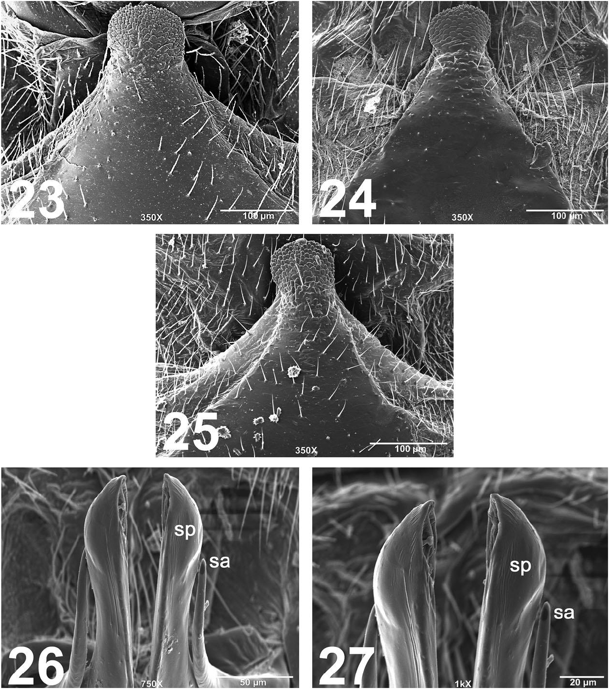
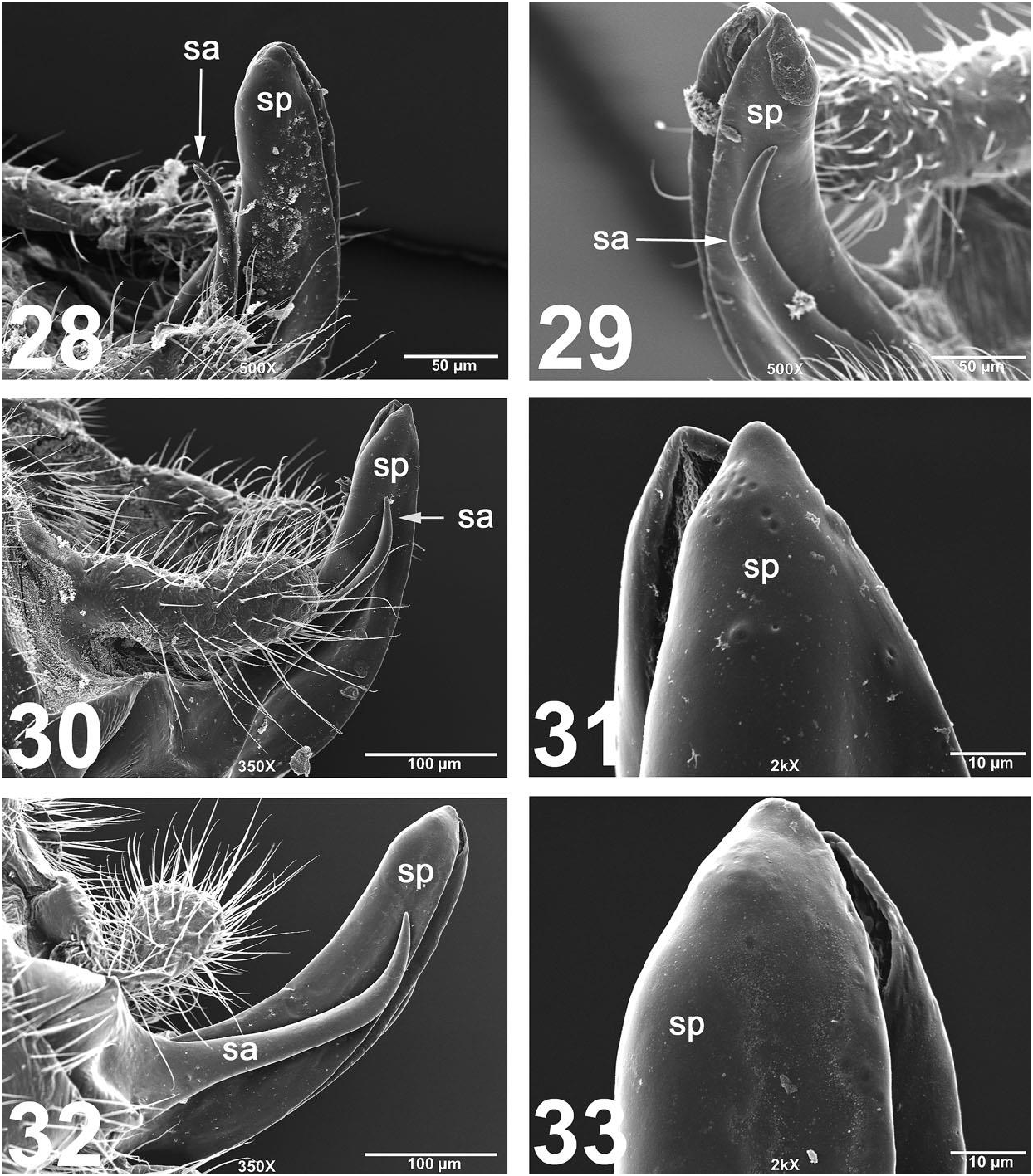
( Figs. 23‒33 View Figs View Figs )
Nemoura tenuis Pictet 1841:375 View in CoL . Type ( ZMHB), Philadelphia, (Philadelphia Co.), Pennsylvania
Leuctra tenuis: Illies 1966:109 View in CoL
Leuctra tenuis: Zwick 1973:407 View in CoL
Male. The 7th abdominal dorsal process is narrowly-triangular in shape, tapering to a tip that is bulbous and rounded posteriorly ( Figs. 23‒25 View Figs ). The specilla are ca. parallel-sided throughout length, except at the tip; specilla gently recurved anteriorly and mostly smooth distally ( Figs. 28‒30, 32 View Figs ); lacking a terminal spur or raised tubercles; bearing few pits distally ( Figs. 31, 33 View Figs ). The subanal lobes are narrow basally, tapering and gently recurved distally, ca. ¾ the length of the specilla ( Figs. 28‒30, 32 View Figs ).
Material examined. USA, Alabama, Cleburne Co., Hillabee Creek , 33.4855, -85.7934, 16 October 2005, A.L. Sheldon, 3♂ ( WKUC) GoogleMaps . Connecticut, Tolland Co., Roaring Brook, Rte. 32, 6 km S Stafford Springs , 41.9035, -72.2878, 29 June 2006, S.A. Grubbs, 1♂, 2♀ ( WKUC) GoogleMaps ; Windham Co., Bungee Brook , 3.5 km S Eastford, 41.8713, -72.0878, 29 June 2006, S.A. Grubbs, 1♂, 1♀ ( WKUC) GoogleMaps . Indiana, Harrison Co., tributary to West Fork Mosquito Creek , 4 km E Laconia, 38.0245, -86.0393, 20 October 2002, S.A. Grubbs, 3♂, 4♀ ( WKUC) GoogleMaps . Kentucky, Harlan Co., Watts Creek, Blanton Forest State Nature Preserve, 36.8619, -83.3753, 11 July‒3 September 2009, M.A. Floyd, 6♂ ( DCTC) GoogleMaps ; same locality but 9 September‒4 November 2009, M.A. Floyd, 6♂ ( DCTC) GoogleMaps . Maryland, Allegany Co., Deep Run, Green Ridge State Forest , 39.6531, -78.4523, 4 July 1996, S.A. Grubbs, 2♂, 7♀ ( WKUC) GoogleMaps ; same locality but 7 August 1998, S.A. Grubbs, 6♂, 2♀ ( WKUC) GoogleMaps ; Garrett Co., Middle Fork, Savage River State Forest , 39.5130, -79.1548, 3 July 1996, S.A. Grubbs, 15♂, 7♀ ( WKUC) GoogleMaps ; Youghioghenny River , 39.5659, -79.4293, 13 July 1996, S.A. Grubbs, 4♂, 1♀ ( WKUC) GoogleMaps . Massachusetts, Worcester Co., Stillwater River, Rte. 140, 5 km E Princeton , 42.4463, -71.8168, 28 June 2006, S.A. Grubbs, 4♂, 4♀ ( WKUC) GoogleMaps ; Burnshirt River, Rte. 62, 5 km ENE Barre , 42.4363, - 72.0528, 28 June 2006, S.A. Grubbs, 1♂ ( WKUC) GoogleMaps . North Carolina, Haywood Co., tributary to Mount Sterling Creek, FR 289, Pisgah National Forest , 35.7452, -83.0700, 11 July 1997, S.A. Grubbs, 1♂, 4♀ ( WKUC) GoogleMaps ; Right Hand Prong, FS 97, Pisgah National Forest , 35.3711, -82.9405, 22 July 2015, A.L. Sheldon, 1♂ ( WKUC) GoogleMaps ; Yancey Co., South Toe River, Pisgah National Forest , 35.7517, -82.2205, 17 July 2015, A.L. Sheldon, 2♂ ( WKUC) GoogleMaps . Ohio, Adams Co., Waggoner Run, Abner Hollow , 12 km SE West Union, 38.7179, -83.4343, 19 September 2015, S.A. Grubbs, 1♂, 11♀ ( WKUC) . Pennsylvania, Mercer Co., Little Shenango River , 10 km E Greenville, 41.4185, -80.2683, 23 June 1998, S.A. Grubbs, 1♂ ( WKUC) GoogleMaps ; Westmoreland Co., Powdermill Run, Powdermill Nature Reserve , 40.1517, -79.2703, 18 August 1993, S.A. Grubbs, 1♂ ( WKUC) GoogleMaps . Rhode Island, Kent Co., Bucks Horn Brook, 14 km NW Exeter, Nicholas Farm Wildlife Management Area , 41.6952, -71.7566, 18 June 2007, S.A. Grubbs, 3♂, 2♀ ( WKUC) GoogleMaps . Tennessee, Cocke Co., Cosby Creek, Rte. 32, 35.7839, -83.2191, 11 July 1997, S.A. Grubbs, 5♂, 3♀ ( WKUC) GoogleMaps . Virginia, Wythe Co., Reed Creek, FR 221/CR 625, 16 km NW Wytheville , Jefferson National Forest , 36.9809, -81.2801, 24 July 2008, S.A. Grubbs, 1♂, 4♀ ( WKUC) GoogleMaps ; Stony Fork, Reed Creek , U.S. 52, 10 km NW Wytheville, Jefferson National Forest , 36.9774, -81.1864, 24 July 2008, S.A. Grubbs, 2♂, 1♀ ( WKUC) GoogleMaps . West Virginia, Greenbrier Co., Rt. 14, 3 mi E Neola, 6 September 2008, L. T. Miller, 1♂, 1♀ ( DCTC) ; Mercer Co., Camp Creek State Forest , 18 September 2008, L. T. Miller, 1♂ ( DCTC) ; Randolph Co., nr. Laneville, Dolly Sods , 25 September 2008, L. T. Miller, 1♂ ( DCTC) ; Tucker Co., Red Creek, Laneville , 20 August 2011, no collector information, 2♂, 3♀ ( DCTC) .
Distribution. Canada: NB, NS, ON, PQ. USA: AL, AR, CT, DE, IA, IL, IN, KY, MA, MD, ME, MI, MN, MO, NJ, NY, OH, OK, PA, VA, WI, WV ( DeWalt et al. 2015), NC, RI (new state records).
Remarks. Examination of material from throughout the eastern Nearctic region revealed consistency with the shapes of the paraprocts and the dorsal process on the 7 th abdominal tergum. Leuctra tenuis is a broadly-distributed species known from Quebec and the Canadian Maritime provinces of New Brunswick and Nova Scotia southwest to Alabama and westward to Minnesota and Oklahoma ( DeWalt et al. 2015).
| T |
Tavera, Department of Geology and Geophysics |
No known copyright restrictions apply. See Agosti, D., Egloff, W., 2009. Taxonomic information exchange and copyright: the Plazi approach. BMC Research Notes 2009, 2:53 for further explanation.
|
Kingdom |
|
|
Phylum |
|
|
Class |
|
|
Order |
|
|
Family |
|
|
Genus |
Leuctra tenuis ( Pictet 1841 )
| Grubbs, Scott A. 2015 |
Leuctra tenuis: Zwick 1973:407
| Zwick, P. 1973: 407 |
Nemoura tenuis
| Illies, J. 1966: 109 |
| Pictet, F. J. 1841: 375 |