
Anteon madagascolum ( Benoit, 1954 )
|
publication ID |
https://doi.org/ 10.11646/zootaxa.4630.1.1 |
|
publication LSID |
lsid:zoobank.org:pub:8D375836-CCBA-473C-836F-6ABD44B4F881 |
|
persistent identifier |
https://treatment.plazi.org/id/03E987E2-FF0F-2AEC-FF3E-D59BFDAFFE70 |
|
treatment provided by |
Plazi |
|
scientific name |
Anteon madagascolum ( Benoit, 1954 ) |
| status |
|
57. Anteon madagascolum ( Benoit, 1954)
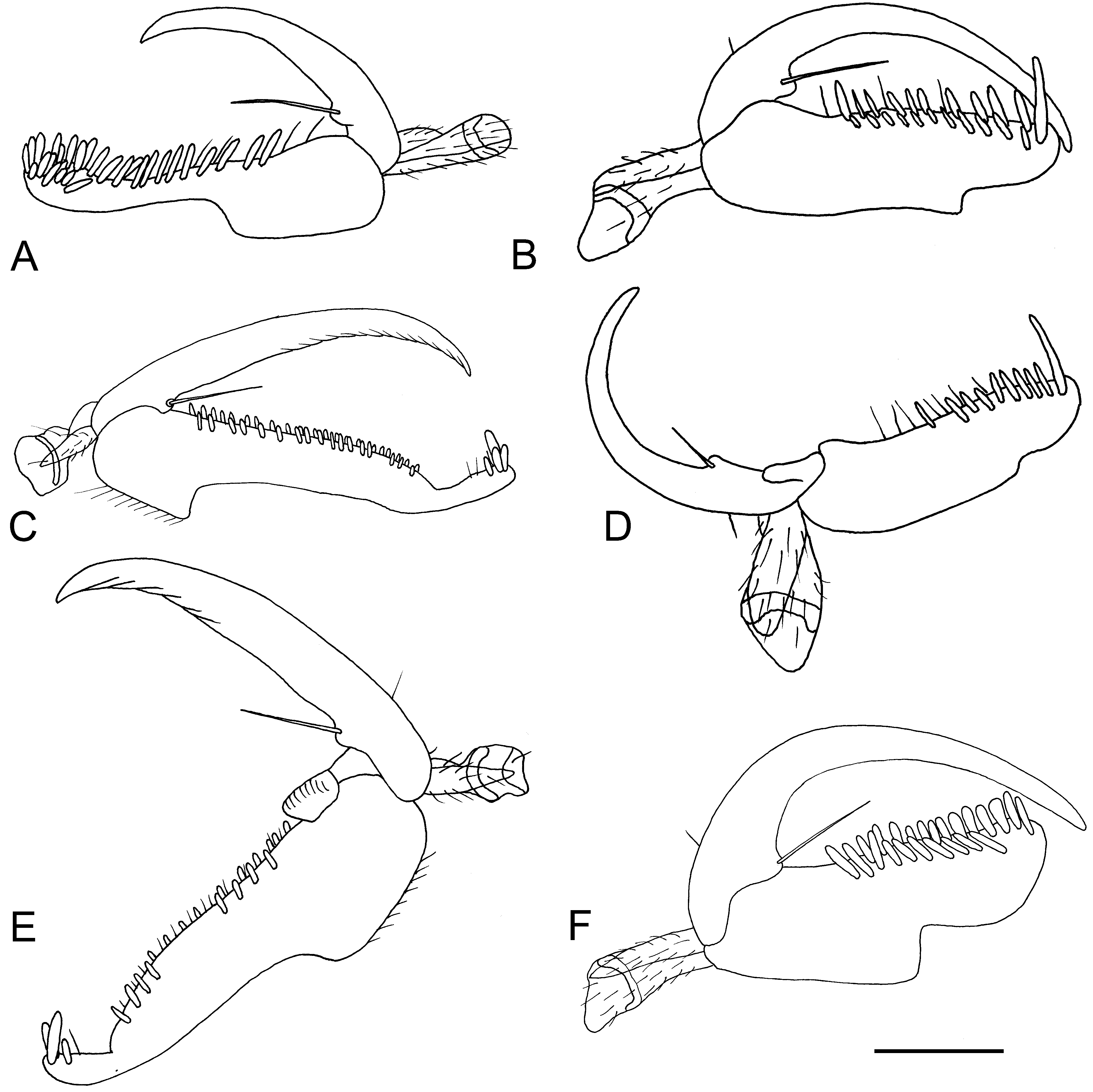
( Figs 56E, F View FIGURE 56 , 57D View FIGURE 57 )
Xenanteon madagascola Benoit 1954: 418 .
Anteon madagascolum (Benoit) : Olmi 1984: 393; 1994c: 4; Azevedo et al. 2010: 878.
Anteon brooksi Olmi 2003: 26 (syn. nov.); type locality: Antananarivo ( Madagascar); Azevedo et al. 2010: 876.
Description. ♀. Fully winged; body length 2.5–3.0 mm. Head black, except mandible testaceous (with teeth brown); antenna brown, except antennomeres 1–6 or 1–4 testaceous (occasionally antenna completely brown or testaceous, except antennomere 10 darkened); mesosoma and metasoma black; tegula testaceous; legs brown, except tarsi testaceous, or testaceous, except metacoxa brown. Antenna clavate; antennomeres in following proportions: 13:5:4:4:4:4:5:5:5:7. Head shiny, granulate and reticulate rugose; frontal line present; frons with or without lateral keels near orbits and directed towards antennal toruli; occipital carina complete; POL = 7; OL = 4; OOL = 5; OPL = 6; TL = 4. Pronotum shiny, granulate; posterior surface very long, more than 0.5 × as long as mesoscutum (10:13); pronotal tubercle reaching tegula. Mesoscutum shiny, granulate. Notauli absent; occasionally notauli present and incomplete, reaching about 0.2–0.3 × length of mesoscutum. Mesoscutellum and metanotum shiny, slightly granulate. Metapectal-propodeal disc with strong transverse posterior keel, reticulate rugose; propodeal declivity granulate and with numerous irregular keels or sculptured by small areolae, without longitudinal keels. Forewing hyaline, without dark transverse bands; distal part of 2r-rs&Rs vein much shorter than proximal part (3:9). Protarsomeres in following proportions: 7:2:3:3:12. Protarsomere 4 produced into hook, about 0.5 × as long as basal part of 5. Enlarged claw ( Fig. 57D View FIGURE 57 ) with proximal prominence bearing one long bristle. Protarsomere 5 ( Fig. 57D View FIGURE 57 ) with two rows of 10–14 lamellae, among which one very long distal lamella. Tibial spurs 1/1/2.
♂ (not reared; tentatively associated to the above ♀). Fully winged; body length 1.0– 1.9 mm. Head black, except mandible testaceous; antenna testaceous, except antennomeres 3–10 darkened (in holotype of A. brooksi , antenna totally testaceous; in other specimens, antenna brown, except scape and pedicel testaceous); mesosoma and metasoma black; occasionally metasoma brown; legs testaceous, except coxae, clubs of femora and tibiae partly brown (in holotype of A. brooksi , pro- and mesoleg completely testaceous). Antenna filiform; antennomeres in following proportions: 6:3.5:3:3:3:3:3:3:3:4.5. Head dull, reticulate rugose; frontal line complete; occipital carina complete; POL = 6; OL = 3; OOL = 3; OPL = 2; TL = 3. Mesoscutum shiny, slightly or strongly granulate. Notauli incomplete, reaching about 0.3–0.4 × length of mesoscutum. Mesoscutellum and metanotum shiny, unsculptured.
Metapectal-propodeal disc with strong transverse posterior keel, reticulate rugose; propodeal declivity without longitudinal keels, completely reticulate rugose (in specimen from Madagascar, 21°13.67’S 47°22.19’E, propodeal declivity with tracks of two complete longitudinal keels). Forewing hyaline, without dark transverse bands; distal part of 2r-rs&Rs vein much shorter than proximal part (1.5:5.5). Paramere ( Figs 56E, F View FIGURE 56 ) candelabrum shaped, with distal part very slender, with an inner lobe large or small, covered or not with papillae. Tibial spurs 1/1/2.
Material examined. Types: ♀ holotype of A. madagascolum : MADAGASCAR: Toliara, Bekily , XI.1938 , A. Seyrig leg. ( MNHN); ♂ holotype of A. brooksi : MADAGASCAR: Antananarivo, Antananarivo, 25–27.X.1984 , YPT, Robert W. Brooks leg. ( NAMUK). Paratype of A. madagascolum : MADAGASCAR: same locality label as holotype, IX.1938 , A. Seyrig leg., 1♀ ( MRAC); Antsiranana, Antsiranana, 1893, Ch. Alluaud leg. , 1♀ (not exam- ined) ( Benoit 1954); Fianarantsoa, Ranomafana , X.1938 , A. Seyrig leg., 1♀ (not examined) ( Benoit 1954). Other material: COMOROS ISLANDS: Mohéli Island, Ouallah , 12°18’13’’S 43°40’06’’E, 500 m, 18–22.I.2009 GoogleMaps , MT, rainforest, B.L. Fisher et al. leg., BLF20683 , 1♂ ( CAS). MADAGASCAR: Antananarivo, 11.5 km 147° SSE of Anjozorobe, 3 km 41°NE of Andranomay, 18°28.24’S 47°57.36’E, 1300 m, 5–13.XII.2000 GoogleMaps , MT, montane rainforest, Fisher , Griswold et al. leg., code BLF 2375 , 2♂♂ ( CAS); Antananarivo, 46 km NE of Ankazobe , Ambohitan- tely, 18°11.88’S 47°16.89’E, 700 m, 17–24.X.2003 GoogleMaps , MT, sclerophyl forest, M. Irwin & R. Harin’Hala leg., MA-27- 02, 1♂ ( CAS); Antsiranana, Ankarana, IX.1986 , MT, Jane Wilson leg., 1♀ ( NHMUK); Antsiranana, 7 km N of Joffreville , 12°20’S 49°15’E, 300 m, 7–27.IV.2001 GoogleMaps , dry forest, MT, R. Harin’Hala leg., MA- 01-07-10, 1♂ ( CAS); Antsiranana, Diana Region, Orangea dry forest, Ramena , Baie de dune, 900 m E of Camp Minier , 23.II–2.III.2011 , 12°13.97’ S 49°21.99’E, M. Irwin, R.Harin’Hala leg., MT, dry forest, elev. 152 m, MG-62-11, 1♂ ( CAS); same locality label, 15–22.VI.2011 , MG-62-27, 1♂ ( CAS); same locality label, 18–26.V.2011 , MG-62-23, 1♂ ( CAS); Antsiranana, Orangea , 3 km E of Ramena near fort, 12°14.49’S 49°22.17’E, 65 m, 23–27.I.2001 GoogleMaps , MT, littoral forest on sand, MA- 01-05-02, M.E. Irwin, E.I. Schlinger & R. Harin’Hala leg., 1♂ ( CAS); Antsiranana, Montagne d’Ambre Nat. Park , 12°30.52’S 49°10.53’E, Antsiranana, 960 m, 26–29.I.2001 GoogleMaps , MT, M.E. Irwin, E.I. Schlinger & R. Harin’Hala leg., MA-01-01A-02, 3♂♂ (2 in CAS, 1 in MOLC); same locality label, 7–27.I.2007 GoogleMaps , M. Irwin, F. Parker & R. Harin’Hala leg., MA-01-01A-16, 1♂ ( CAS); same locality label, 7–27.I.2007 GoogleMaps , MA-01-01A-16, 1♂ ( CAS); same locality label, 21–28.I.2001 GoogleMaps , M.E. Irwin, E.I. Schlinger & R. Harin’Hala leg., MA-01-01A-01, 1♂ ( CAS); same locality label, 27.I–11.II.2007 GoogleMaps , MA-01-01A-17, 1♀ ( MOLC); same locality label, 21–26.I.2001 GoogleMaps , MA- 01-01A-01, 4♂♂ (3 in CAS, 1 in MOLC); Antsiranana, Montagne d’Ambre National Park , 12°31’S 49°11’E, 975 m, 19.III–5.IV.2001 GoogleMaps , MT, M.E. Irwin, E.I. Schlinger & R. Harin’Hala leg., MA-01-01B-07, 1♂ ( CAS); Antsirinana, Montagne d’Ambre National Park , 12°31.13’S 49°10.45’E, 1125 m, 29.I–11.II.2001 GoogleMaps , MT, R. Harin’Hala leg., MA- 01-01D-03, 2♂♂ ( CAS); same locality label, 14–30.V.2001 GoogleMaps , MA-01-01D-11, 1♂ ( CAS); Antsiranana, Montagne d’Ambre National Park , 12°31’S 49°11’E, 975 m, MT, M.E. Irwin, E.I. Schlinger & R. Harin’Hala leg., MA-01- 01B-01 GoogleMaps , 1♂ ( CAS); Antsiranana, Marojejy National Park, Manantenina river , 27.6 km 35° NE Andapa, 9.6 km 327° NNW Manantenina, 14°26.06’S 49°45.36’E, 775 m, 11–14.XII.2005 GoogleMaps , MT, rainforest, B.L. Fisher et al. leg., BLF13383 , 1♂ ( CAS); Antsiranana, SAVA Region, Vohemar District, Andranotsimaty dry forest, 9 km NE Daraina, 13°10.17’S 49°42.04’E, 90 m, 19–26.XII.2010 GoogleMaps , MT, dry dense forest, M. Irwin, R. Harin’Hala leg., MG-57-12, 1♂ ( CAS); same locality label, 4–10.X.2010 GoogleMaps , MG-57-01, 1♂ ( CAS); Fianarantsoa, 7 km W of Ranomafana , 900 m, 1–7.III.1990 , W.E. Steiner leg., 1♀, 1♂ ( USNM); Fianarantsoa, Ranomafana National Park, Belle Vue at Talatakely, 21°15.99’S 47°25.21’E, 1020 m, 10–14.I.2002 GoogleMaps , secondary tropical forest, MT, R. Harin’Hala leg., 1♀ ( MOLC); same locality label, 4–12.II.2002 GoogleMaps , MA-02-09C-15, 2♂♂ ( CAS); same locality label, 10–14.I.2002 GoogleMaps , MA-02-09C-11, 2♂♂ ( CAS);same locality label, 26.II–4.III.2002 GoogleMaps , MA-02-09C-18, 1♂ ( CAS); same locality label, 28.XI–6.XII.2001 GoogleMaps , MA-02-09C-05, 3♂♂ ( CAS); same locality label, 4–14.VII.2002 GoogleMaps , MA-02-09C-34, 1♂ ( CAS); same locality label, 24.VII–4.VIII.2002 GoogleMaps , MA-02-09C-36, 5♂♂ ( CAS); same locality label, 8–15.XI.2001 GoogleMaps , MA-02-09C-02, 1♂ ( MOLC); same locality label, 4–16.V.2003 GoogleMaps , MA-02-09C-60, 2♂♂ ( CAS); same locality label, 12–23.IV.2003 GoogleMaps , MA-02-09C- 58, 1♂ ( CAS); same locality label, 15–22.XI.2001 GoogleMaps , MT, secondary tropical forest, R. Harin’Hala leg., MA-02-09C- 03, 1♂ ( CAS); same locality label, 19–26.II.2002 GoogleMaps , MA-02-09C-17, 13♂♂ (8 in CAS, 5 in MOLC); same locality label, 15–22.XI.2001 GoogleMaps , MA-02-09C-03, 1♂ ( CAS); same locality label, 23.VI–4.VII.2002 GoogleMaps , MA-02-09C-33, 2♂♂ ( CAS); same locality label, 10–21.III.2003 GoogleMaps , MA-02-09C-56, 3♂♂ ( CAS); same locality label, 14–21.I.2002 GoogleMaps , MA- 02-09C-12, 1♂ ( CAS); same locality label, 8–15.XI.2001 GoogleMaps , MA-02-09C-02, 2♂♂ ( CAS); same locality label, 13– 23.VI.2002 GoogleMaps , MA-02-09C-32, 3♂♂ ( MOLC); same locality label, 26–31.III.2002 GoogleMaps , MA-02-09C-22, 3♂♂ ( CAS); same locality label, 12–19.II.2002 GoogleMaps , MA-02-09C-16, 4♂♂ ( CAS); same locality label 22–28.XI.2001 GoogleMaps , MA-02-09C- 04, 9♂♂ (7 in CAS, 2 in MOLC); same locality label, 16.X–8.XI.2001 GoogleMaps , MA-02-09C-01, 6♂♂ ( CAS); Fianarantsoa, Ranomafana , JIRAMA water works, 21°14.91’S 47°27.13’E, 690 m, 28.XI–6.XII.2001 GoogleMaps , MT, near river, R. Harin’Hala leg., MA-02-09D-05, 4♂♂ (1 in CAS, 3 in MOLC); same locality label, 10–14.I.2002 GoogleMaps , MA-02-09D-11, 1♂ ( CAS); same locality label, 21–24.XII.2001 GoogleMaps , MA-02-09D-08, 1♂ ( CAS); same locality label, 2–10.I.2002 GoogleMaps , MA- 02-09D-10, 3♂♂ ( CAS); Fianarantsoa, Ranomafana National Park, Vohiparara , 21°13.57’S 47°22.19’E, at broken bridge, 1110 m, 21–28.I.2002 GoogleMaps , MT, high altitude rainforest, R. Harin’Hala leg., MA-02-09A-13, 2♂♂ ( CAS); same locality label, 19–26.II.2002 GoogleMaps , MA-02-09A-17, 2♂♂ ( CAS, MOLC); same locality label, 15–25.VII.2002 GoogleMaps , MA-02- 09A-35, 1♂ ( MOLC); same locality label, 14–21.I.2002 GoogleMaps , MA-02-09A-12, 7♂♂ (5 in CAS, 2 in MOLC); same lo- cality label, 21–28.I.2002 , MA-02-09A-13, 2♂♂ ( CAS); same locality label, 22–28.XI.2001 , MA-02-09A-04, 3♂♂ ( CAS); same locality label, 15–21.XII.2001 , MA-02-09A-07, 2♂♂ ( CAS); same locality label, 6–15.XII.2001 , MA-02-09A-06, 2♂♂ ( CAS); Fianarantsoa, Ranomafana National Park, Vohiparara , 21°13.67’S 47°22.19’E, at broken bridge, 1110 m, 25.VII–3.VIII.2002 GoogleMaps , MT, high altitude rainforest, R. Harin’Hala leg., MA-02-08A-36, 5♂♂ (3 in CAS, 2 in MOLC); Fianarantsoa, Ranomafana National Park , radio tower at forest edge, 21°15.05’S 47°24.43’E, 1130 m, 4–12.III.2002 GoogleMaps , MT, mixed tropical forest, R. Harin’Hala leg., MA-02-09B-19, 4♂♂ (3 in CAS, 1 in MOLC); same locality label, 16.X–8.XI.2001 GoogleMaps , MA-02-09B-01, 9♂♂ (8 in CAS, 1 in MOLC); same locality label, 7– 18.VI.2003 GoogleMaps , 1♂ ( CAS); same locality label, 12–19.II.2002 GoogleMaps , MA-02-09B-16, 3♂♂ ( CAS); same locality label, 14– 24.VI.2002 GoogleMaps , MA-02-09B-32, 3♂♂ ( CAS); same locality label, 15–27.IV.2003 GoogleMaps , MA-02-09B-58, 1♂ ( CAS); same locality label, 12–19.III.2002 GoogleMaps , MA-02-09B-20, 4♂♂ ( CAS); same locality label, 9–20.III.2003 GoogleMaps , MA-02-09B-55, 1♀ ( MOLC) , 2♂♂ ( CAS); same locality label, 27.II–9.III.2003 , MA-02-09B-54, 5♂♂ ( CAS); same locality label, 18–29.VI.2003 , MA-02-09B-64, 3♂♂ ( CAS); same locality label, 15–21.XII.2001 , MA-02-09B-07, 2♂♂ ( CAS); same locality label, 22–28.XI.2001 , MA-02-09B-04, 2♂♂ ( CAS); same locality label, 20.III–3.IV.2003 , MA-02- 09B-56, 1♂ ( CAS); same locality label, 27.IV–7.V.2003 , MA-02-09B-59, 2♂♂ ( CAS); same locality label, 24.V– 4.VI.2002 , MA-02-09B-30, 1♂ ( CAS); same locality label, 7–17.V.2003 , MA-02-09B-60, 2♂♂ ( CAS); same local- ity label, 14–21.I.2002 , MA-02-09B-12, 10♂♂ (8 in CAS, 2 in MOLC); same locality label, 27.VI–7.VII.2003 , MA-02-09B-65, 2♂♂ ( CAS); same locality label, 18–27.II.2003 , MA-02-09B-53, 2♂♂ ( CAS, MOLC); same local- ity label, 7–17.VII.2003 , MA-02-09B-66, 1♂ ( CAS); same locality label, 17–30.V.2003 , MA-02-09B-61, 3♂♂ ( CAS); Fianarantsoa, Manombo Special Reserve camp site, 32 km SSE of Farafangana, 23°01.31’S 47°43.20’E, 36 m, 22.V–6.VI.2005 GoogleMaps , MT, lowland rainforest, MA-28-20, M. Irwin, R. Harin’Hala leg., 1♂ ( CAS); same locality label, 30.X–12.XI.2004 GoogleMaps , MA-28-03, 1♂ ( CAS); Fianarantsoa, near Isalo National Park , in dry wash east of Interpre- tive Center, 22°37.60’S 45°21.49’E, 885 m, 12–22.VI.2002 GoogleMaps , MT, in open area, MA-02-11B-32, R. Harin’Hala leg., 1♂ ( MOLC); same locality label, 26.I–3.II.2002 GoogleMaps , MA-02-11B-13, 1♂ ( CAS); same locality label, 7–15.IV.2002 GoogleMaps , MA-02-11B-23, 1♀ ( CAS); Fianarantsoa, Ananalava Forest , 29.6 km 280° W Ranohira, 22°35.30’S 45°07.42’E, 700 m, 1–5.II.2003 GoogleMaps , MT, tropical dry forest, Fisher, Griswold et al. leg., BLF7383, 1♂ ( CAS); Mahajanga, Marotan- drano Special Reserve, Marotandrano , 48.3 km S Mandritsara, 16°17’00’’S 8°48’52’’E, 865 m, 7–8.XII.2007 GoogleMaps , transition humid forest, MT, B.L. Fisher et al. leg., BLF19157 , 1♂ ( MOLC); Mahajanga, Sofia District , 45 km S Antso- hihy, 5 km W of Anjiamangirana, elev. 97 m, 27I–2. II.2011, 15°09.42’S 47°47.05’E, M.Irwin, R.Harin’Hala, MT, Analagnambe dry degraded forest, MG-61-08, 1♂ ( MOLC); same locality label, 2–6.I.2011 , MG-61-04, 1♂ ( CAS); Mahajanga, Besalampy District, Analangidro dry forest, 7 km NE Besalampy, 16°41.49’S 44°31.41’E, 200 ft., 9– 16.X.2007 GoogleMaps , MT, dry forest on sand, M. Irwin & R. Harin’Hala leg., MG-41-03, 2♂♂ ( CAS); same locality label, 28.X–4.XI.2007 GoogleMaps , MG-41-06, 4♂♂ ( CAS); same locality label, 4–11.XI.2007 GoogleMaps , 1♂ ( CAS); same locality label, 11– 18.XI.2007 GoogleMaps , 1♂ ( CAS); same locality label, 18–25.XI.2007 GoogleMaps , 4♂♂ ( CAS); same locality label, 24.IX–2.X.2007 GoogleMaps , 5♂♂ ( CAS); Mahajanga, Maintirano District, Asondrodava dry forest, 15 km N of Maintirano, 17°57.92’S 44°2.13’E, 200 ft., 21–28.I.2008 GoogleMaps , MT, dry forest, M. Irwin, R. Harin’Hala leg., MG-43A-16, 1♂ ( CAS); Mahajanga, Beanka Forest Reserve , 50.2 km E Maintirano, 18°01’35’’S 44°03’02’’E, 250 m, 19–26.X.2009 GoogleMaps , tropical dry forest on tsingy, MT, B.L. Fisher et al. leg., BLF22787 , 1♂ ( CAS); Mahajanga, Analamanitra Forest , 14 km NE Misinjo, 15°55’S 45°57’E, 65 ft., 15–22.I.2008 GoogleMaps , MT, dense dry forest, M. Irwin, R. Harin’Hala leg., MG-38-14, 1♂ ( CAS); Mahajanga, Ampijoroa National Park , 160 km N of Maevatanana on RN 04, 16°19’16’’S 46°48’80’’E, 43 m, 24– 31.VIII.2003 , MT, deciduous forest, R. Harin’Hala leg., MA-25-12, 1♂ ( CAS); same locality label, 9–20.XI.2003 , MA-25-23, 1♂ ( CAS);same locality label, 14–22.IX.2003 , MA-25-15, 1♂ ( CAS); same locality label, 7–14.IX.2003 , MA-25-14, 2♂♂ ( CAS); same locality label, 31.VIII–7.IX.2003 , MA-25-13, 1♂ ( CAS); Mahajanga, Namoroka National Park , 9.8 km 300° WNW Vilanandro, 16°28.00’S 45°21.00’E, 140 m, 4–8.XI.2002 GoogleMaps , MT, tropical dry forest, Fisher, Griswold et al. leg., BLF 6445, 1♂ ( CAS); Toamasina, Ivondro , 1♀ ( AMNH); Mahajanga, Sofia Dis- trict, 45 km S Antsohihy, 5 km W Anjiamangirana, Analagnambe dry degraded forest, 15°09.42’S 47°47.05’E, 97 m, 26.V–2.VI.2011 GoogleMaps , MT, MG-61-15, 2♂♂ ( CAS); Toliara, 12 km NW of Amboasary, Berenty , 5–15.V.1983 , J.S. Noyes & M.C. Day leg., 1♂ ( NHMUK); same locality label, 18–23.V.1983 , 1♂ ( AMNH); Toamasina, Mobot site, Analalava , 7 km SW of Foulpointe, 17°41’36’’S 49°27’37’’E, 60 ft., 16–23.XI.2007 GoogleMaps , MT, sand in low altitude dense humid forest, MG-37B-10, 1♂ ( MOLC); Toliara, 60 km NE of Morondava, Bereboka , 18–23.V.1983 , J.S. Noyes & M.C. Day leg., 4♂♂ ( AMNH, NHMUK); Toliara, Tsimanampetsotsa Nat. Park, Bemanateza Forest, 20.7 km 81°E Efoetse , 23 km 131° SE Beheloka, 23°59.32’S 43°52.50’E, 90 m, 22–26.III.2002 GoogleMaps , beating low vegetation, in spiny forest thicket, Fisher, Griswold et al. leg., BLF 6256, 1♀ ( CAS); same locality label, 22–26.III.2002 GoogleMaps , BLF 6257, 1♂ ( CAS); same locality label, 22–26.III.2002 GoogleMaps , BLF 6257, 1♂ ( CAS); Toliara, Andohahela National Park, Ihazofotsy Parcelle III, 24°50.09’S 46°29.21’E, 80 m, 26.XII.2002 GoogleMaps – 5.I.2003 GoogleMaps , MT, dry spiny forest, M. Irwin, F. Parker & R. Harin’Hala leg., MA- 02-21-05, 1♀ ( CAS); same locality label, 7–17.XII.2003 GoogleMaps , MA- 02-21-41, 1♂ ( CAS); same locality label, 28.IV–6.V.2003 GoogleMaps , MA- 02-21-17, 1♂ ( CAS); Toliara, Andohahela National Park, Tsimelahy , parcelle II, 24°56.21’S 46°37.60’E, 180 m, 16–17.XII.2002 GoogleMaps , MT, transitional forest, M. Irwin, F. Parker & R. Harin’Hala leg., MA- 02-20-09, 2♂♂ ( CAS, MOLC); same locality label, 28.III–8.IV.2003 GoogleMaps , 3♂♂ (2 in CAS, 1 in MOLC); same locality label, 10–20.VII.2003 GoogleMaps , 1♂ ( CAS); same locality label, 17–24.VIII.2003 GoogleMaps , MA- 02-20-36, 1♂ ( CAS); same locality label, 22–29.VI.2003 GoogleMaps , MA- 02-20-30, 3♂♂ ( CAS); same locality label, 30.XI–11.XII.2003 GoogleMaps , MA- 02-20-47, 2♂♂ ( CAS); Toliara, Fiherenana , 23°14.07’S 43°52.15’E, 50 m, 16.X–16.XI.2002 GoogleMaps , MT. degraded gallery forest, MGF047, Frontier Wilderness Project, 1♀ ( CAS); Toliara, Fiherenana , 23°10.37’S 43°57.39’E, 100 m, 22– 28.X.2002 GoogleMaps , MT. gallery forest, MGF041, Frontier Wilderness Project, 1♂ ( MOLC); Toliara, Ranobe , 23°02.22’S 43°36.377’E, 30 m, 5–9.II.2003 GoogleMaps , MT, spiny forest thicket, MGF058, Frontier Wilderness Project, 1♂ ( CAS); Toli- ara, Ranobe , 23°02.367’S 43°36.617’E, 20 m, 8–15.XI.2003 GoogleMaps , MT, gallery forest, MGF084, Frontier Wilderness Project, 1♀ ( MOLC); Toliara, Mikea Forest , NW of Manombo, 22°54.22’S 43°28.53’E, 30 m, 6–16.I.2002 GoogleMaps , MT, deciduous dry forest, R. Harin’Hala leg., MA-02-18A-09, 1♀ ( CAS); same locality label, 6–16.I.2002 GoogleMaps , MA-02- 18A-09, 1♂ ( CAS); Toliara, Mikea Forest , NW of Manombo, 22°54.80’S 43°28.93’E, 37 m, 18–29.IV.2002 GoogleMaps , MT, spiny forest, R. Harin’Hala leg., MA-02-18B-20, 1♂ ( CAS); same locality label, 11–24.II.2003 GoogleMaps , MA-02-18A-46, 1♂ ( CAS); Toliara, Zombitse National Park , near national road, 22°50.43’S 44°43.87’E, 825 m, 15.X–9.XI.2001 GoogleMaps , MT, deciduous spiny forest, R. Harin’Hala leg., MA-02-13B-01, 1♂ ( CAS); same locality label, 7–13.VII.2002 GoogleMaps , 1♂ ( CAS); same locality label, 13–20.III.2002 GoogleMaps , 1♂ ( MOLC); Toliara, Zombitse National Park , near ANGAP office, 22°53.19’S 44°41.53’E, 840 m, 15.X–9.XI.2001 GoogleMaps , MT, deciduous spiny forest, M.E. Irwin, F.D. Parker & R. Harin’Hala leg., MA-02-13A-01, 2♂♂ ( CAS, MOLC); Toliara, Beza Mahafaly Reserve , parcelle I near research station, 23°41.19’S 44°35.46’E, 165 m, 20–24.XII.2002 GoogleMaps , MT, dry deciduous forest, R. Harin’Hala leg., MA-02- 14A-45, 1♂ ( CAS); Toliara, Beza Mahafaly Reserve, parcelle II near Bellevue , 23°41.39’S 44°34.53’E, 180 m, 15.X–10.XI.2001 GoogleMaps , MT, spiny forest, M.E. Irwin, F.D. Parker & R. Harin’Hala leg., MA-02-14B-01, 1♂ ( CAS); Toliara, Antafoky , 23°28.43’S 44°03.51’E, 55 m, 25–28.I.2002 GoogleMaps , MT, gallery forest, Frontier Project leg., MGF003, 1♂ ( CAS); Toliara, Berenty Special Reserve , 8 km NW Amboasary, 25°00.40’S 46°18.20’E, 85 m, 24.III–3.IV.2003 GoogleMaps , MT, gallery forest, M. Irwin, F. Parker, R. Harin’Hala leg., MA- 02-22-20, 1♂ ( CAS); same locality label, 16– 27.XII.2002 GoogleMaps , 2♂♂ ( CAS); same locality label, 25.II–7.III.2003 GoogleMaps , MA- 02-22-17, 2♂♂ ( CAS, MOLC); same locality label, 17–24.III.2003 GoogleMaps , MA- 02-22-19, 3♂♂ (2 in CAS, 1 in MOLC); same locality label, 5–15.II.2003 GoogleMaps , MA- 02-22- 15, 4♂♂ ( CAS); same locality label, 7–17.III.2003 GoogleMaps , MA- 02-22-18, 5♂♂ ( CAS); same locality label, 15–25.II.2003 GoogleMaps , MA- 02-22-16, 3♂♂ ( CAS); same locality label, 17–26.I.2003 GoogleMaps , MA- 02-22-13, 4♂♂ ( CAS); same locality label, 16–27.XII.2002 GoogleMaps , MA- 02-22-10, 2♂♂ ( CAS); same locality label, 26.I–5.II.2003 GoogleMaps , MA- 02-22-14, 3♂ # ♂ ( CAS); To- liara, Berenty Special Reserve , 8 km NW Amboasary, elev 35 m, 25°01.26’S 46°18.33’E, 22–30.XI.2003 GoogleMaps , M.Irwin, F. Parker & R.Harin’Hala, MT, spiny forest, MA-02-22A-04, 3♂♂ (2 in CAS, 1 in MOLC); same locality label, 7–17.X.2004 GoogleMaps , 1♂ ( CAS); Toliara, Berenty Reserve , 80 km W Fort Dauphin, 25°00’S 46°17’E, 7.IV.1994 GoogleMaps , MT, M. Wasbauer leg., 1♂ ( DEUCD); Toliara, Beroboka village , 45 km NE Morondava, 19°58.65’S 44°39.92’E, 420 ft., 8–16.VI.2008 GoogleMaps , MT, Antsarongaza gallery forest, MG-45B-26, M. Irwin, R. Harin’Hala leg. , 3♂♂ ( CAS); same lo- cality label, 430 ft., 22–30.V.2008 , MG-45A-24, 1♂ ( MOLC); same locality label, 1–9.VII.2008 , MG-45A-29, 2♂♂ ( CAS); Toliara, Mite Forest , 20.7 km 29° WNW Tongobory, 23°31.27’S 44°07.17’E, 75 m, 27.II–3.III.2002 GoogleMaps , MT, in gallery forest, Fisher, Griswold et al. leg., BLF 5849, 1♂ ( CAS); Toliara, Forêt de Kirindy , 15.5 km 64° ENE Marofandilia, 20°04.09’S 044°39.38’E, 6–13.VIII.2008 GoogleMaps , B.L. Fisher , MT, tropical dry forest, el 30 m, BLF18285_ 40 , 1♂ ( MOLC); same locality label, 15–22.X.2008 , BLF18285_50 , 1♂ ( MOLC); Toliara, Androimpano Forest , 5 km E of Itampolo, 24°39.02’S 43°57.79’E, 130 m, 3–16.VII.2009 GoogleMaps , MT, path in dry forest, M. Irwin, R. Harin’Hala leg., MG-54C-33, 1♂ ( CAS); Toliara, Tsimanampetsotsa National Park, Mitoho Forest , 24°02.91’S 43°45.14’E, 120 m, 9–15.I.2009 GoogleMaps , MT, transitional forest, M. Irwin, R. Harin’Hala leg., MG-53C-12, 1♂ ( CAS); same locality label, 24–29.X.2008 GoogleMaps , MG-53C-01, 1♂ ( CAS); same locality label, 4–12.XII.2008 GoogleMaps , MG-53C-07, 1♂ ( CAS); same locality label, 24–29.X.2008 GoogleMaps , across trail at base of escarpment, dense dry forest, MG-53B-01, 1♂ ( CAS) .
Hosts. Unknown.
Distribution. Comoros Islands, Madagascar.
Remarks. The record from Diego Suarez Island reported by Olmi (1984) is erroneous, because it was based on a misinterpretation of a paper of Benoit (1954), and instead refers to the town of Diégo-Suarez situated in Madagascar. The new synonymy of Anteon brooksi is justified because the small difference in the ♂ genitalia of A. madagascolum (the only difference between these two species) falls within the range of variability of the species, as shown by the study of hundreds of specimens.

No known copyright restrictions apply. See Agosti, D., Egloff, W., 2009. Taxonomic information exchange and copyright: the Plazi approach. BMC Research Notes 2009, 2:53 for further explanation.
|
Kingdom |
|
|
Phylum |
|
|
Class |
|
|
Order |
|
|
Family |
|
|
Genus |
Anteon madagascolum ( Benoit, 1954 )
| Olmi, Massimo, Copeland, Robert S. & Noort, Simon Van 2019 |
Anteon brooksi
| Azevedo, C. O. & Madl, M. & Olmi, M. 2010: 876 |
| Olmi, M. 2003: 26 |
Anteon madagascolum
| Azevedo, C. O. & Madl, M. & Olmi, M. 2010: 878 |
| Olmi, M. 1994: 4 |
| Olmi, M. 1984: 393 |
Xenanteon madagascola
| Benoit, P. L. G. 1954: 418 |