
Anteon sanyatense Olmi, 2009
|
publication ID |
https://doi.org/ 10.11646/zootaxa.4630.1.1 |
|
publication LSID |
lsid:zoobank.org:pub:8D375836-CCBA-473C-836F-6ABD44B4F881 |
|
persistent identifier |
https://treatment.plazi.org/id/03E987E2-FF11-2AF7-FF3E-D3DEFDB4FB94 |
|
treatment provided by |
Plazi |
|
scientific name |
Anteon sanyatense Olmi, 2009 |
| status |
|
83. Anteon sanyatense Olmi, 2009
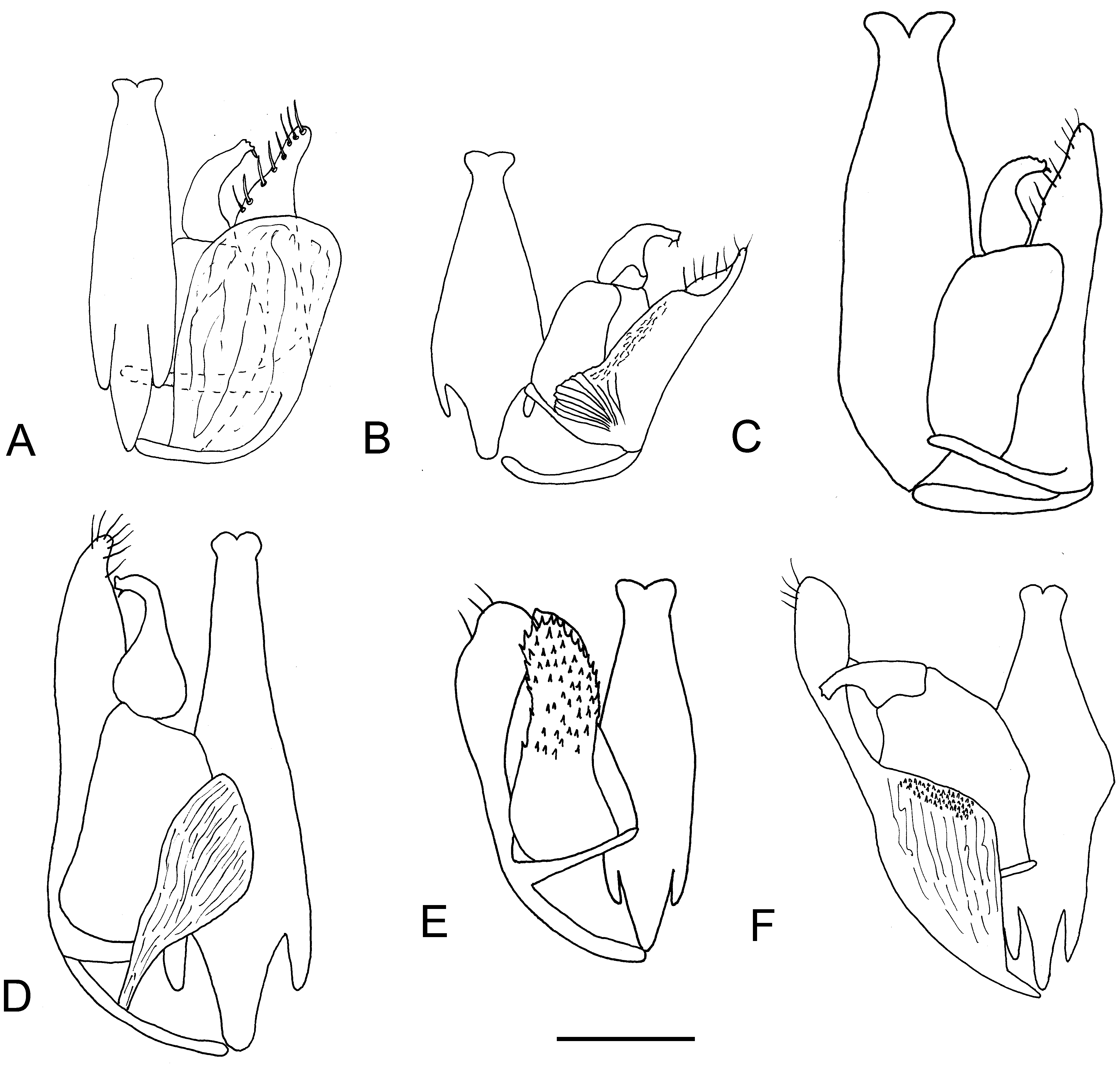
( Fig. 69D View FIGURE 69 )
Anteon sanyatense Olmi 2009b: 450 View Cited Treatment ; Olmi et al. 2015: 348.
Description. ♂. Fully winged; body length 2.2–2.6 mm. Head black, except mandible testaceous; antenna brown, except scape and pedicel testaceous (antenna totally testaceous in specimen from Kenya, Funzi Island); mesosoma and metasoma black; legs testaceous, except metacoxa partly black or darkened and club of metafemur brown or darkened. Antenna filiform; antennomeres in following proportions: 11:6:7:6:5.5:6:6:6:6:8. Head dull, granulate and strongly reticulate rugose; frontal line complete; occipital carina complete; POL = 8; OL = 4; OOL = 5; OPL = 4; TL = 3; greatest breadth of lateral ocelli about as long as TL. Mesoscutum dull, granulate and irregularly rugose. Notauli hardly visible, absent or incomplete and reaching about 0.3 × length of mesoscutum. Mesoscutellum and metanotum shiny, smooth, punctate, unsculptured among punctures. Metapectal-propodeal disc with strong transverse posterior keel, reticulate rugose; propodeal declivity reticulate rugose, with two longitudinal keels and median area sculptured by areolae less wide than those of the lateral areas (except large areolae along margins); in specimen from Kenya, Funzi Island, median area almost completely sculptured by large areolae. In specimen from Kenya, 4.32664°S 39.52462°E, propodeal declivity with two incomplete longitudinal keels. Forewing hyaline, without dark transverse bands; distal part of 2r-rs&Rs vein much shorter than proximal part (2.5:9). Paramere ( Fig. 69D View FIGURE 69 ) without distal inner process and with proximal membranous process. Tibial spurs 1/1/2.
♀. Unknown.
Material examined. Type: ♂ holotype: SOUTH AFRICA: KwaZulu-Natal, Louwsberg, Sanyati Farm , 1090 m, 27°34‘S 31°17.9‘E, 1–24.VI.2006, MT, M. Mostovski leg. ( NMSA) GoogleMaps . Other material: KENYA: Coast Prov., Mrima Hill Forest , 4.48576°S 39.25845°E, 212 m, 17–31.V.2011, MT, indigenous forest edge, R. Copeland leg., 1♂ ( NMK) GoogleMaps ; same locality label, 27.VI–11.VII.2011, 1♂ ( NMK) GoogleMaps ; same locality label, 3–17.X.2011, 1♂ ( MOLC) GoogleMaps ; Coast Prov., Taita Hills, Ngangao Forest , 3.36100°S 38.34186°E, 1848 m, 24.VII–7.VIII.2001, MT, indigenous forest, R. Copeland leg., 2♂♂ ( NMK) GoogleMaps ; Coast Prov., Taita Hills, Chawia Forest , 3.47908°S 38.34162°E, 1614 m, 24.VII– 7.VIII.2011, MT, next to small forest pond, R. Copeland leg., 1♂ ( NMK) GoogleMaps ; same locality label, 16–30.X.2011, 1♂ ( NMK) GoogleMaps ; Coast Prov., Funzi Island , 4.57749°S 39.43825°E, near sea level, 4–10.VII.2012, MT, near Funzi workshop, ICIPE/NMK Funzi Island Expedition leg., 4♂♂ ( NMK) GoogleMaps ; Coast Prov., Muhaka Forest , 4.32530°S 39.52345°E, 52 m, 30.V–19.VI.2013, 6 m MT, indigenous forest, R. Copeland leg., 8♂♂ (7 in NMK, 1 in MOLC) GoogleMaps ; Coast Prov., Muhaka Forest , 4.32664°S 39.52462°E, 41 m, 9–23.VIII.2015, MT, indigenous forest, R. Copeland leg., 1♂ ( NMK) GoogleMaps ; same locality label 5–19.XI.2015, 1♂ ( NMK) GoogleMaps ; Coast Prov., Kasigau Mtn. , 3.82700°S 38.64875°E, 1065 m, 19.X–2.XI.2011, MT, indigenous forest, next to campsite in forest, R. Copeland leg., 2♂♂ ( NMK) GoogleMaps ; Coast Prov., Kasigau Mtn. , 3.82080°S 38.64178°E, 737 m, 7–21.IX.2011, MT, woodland with grass, R. Copeland leg., 2♂♂ ( NMK) GoogleMaps ; Coast Prov., Kasigau Mtn. , 3.82700°S 38.64875°E, 1065 m, 21.IX–5.X.2011, MT, indigenous forest, next to campsite in forest, R. Copeland leg., 1♂ ( NMK) GoogleMaps ; Coast Prov., Taita Hills , Mwatate area, 3.48444°S 38.33251°E, 1011 m, 13–27.XII.2011, MT, below Bura Bluff, riverine forest, R. Copeland leg., 1♂ ( NMK) GoogleMaps ; Eastern Prov., Kiri- miri Forest , near top of hill, 0.42563°S 37.54460°E, 1664 m, 12–26.V.2011, MT, indigenous forest, R. Copeland leg., 1♂ ( NMK) GoogleMaps ; Eastern Prov., Ngaia Forest , 0.32442°N 38.05038°E, 1057 m, bottom of forest, 3–17.IX.2011, MT, inside indigenous forest, R. Copeland leg., 1♂ ( NMK) GoogleMaps .
Hosts. Unknown.
Distribution. Kenya, South Africa.
No known copyright restrictions apply. See Agosti, D., Egloff, W., 2009. Taxonomic information exchange and copyright: the Plazi approach. BMC Research Notes 2009, 2:53 for further explanation.
|
Kingdom |
|
|
Phylum |
|
|
Class |
|
|
Order |
|
|
Family |
|
|
Genus |
Anteon sanyatense Olmi, 2009
| Olmi, Massimo, Copeland, Robert S. & Noort, Simon Van 2019 |