
Anteon kivuanum (Benoit, 1951)
|
publication ID |
https://doi.org/ 10.11646/zootaxa.4630.1.1 |
|
publication LSID |
lsid:zoobank.org:pub:8D375836-CCBA-473C-836F-6ABD44B4F881 |
|
persistent identifier |
https://treatment.plazi.org/id/03E987E2-FF36-2AD5-FF3E-D59BFB17F8E5 |
|
treatment provided by |
Plazi |
|
scientific name |
Anteon kivuanum (Benoit, 1951) |
| status |
|
53. Anteon kivuanum (Benoit, 1951)
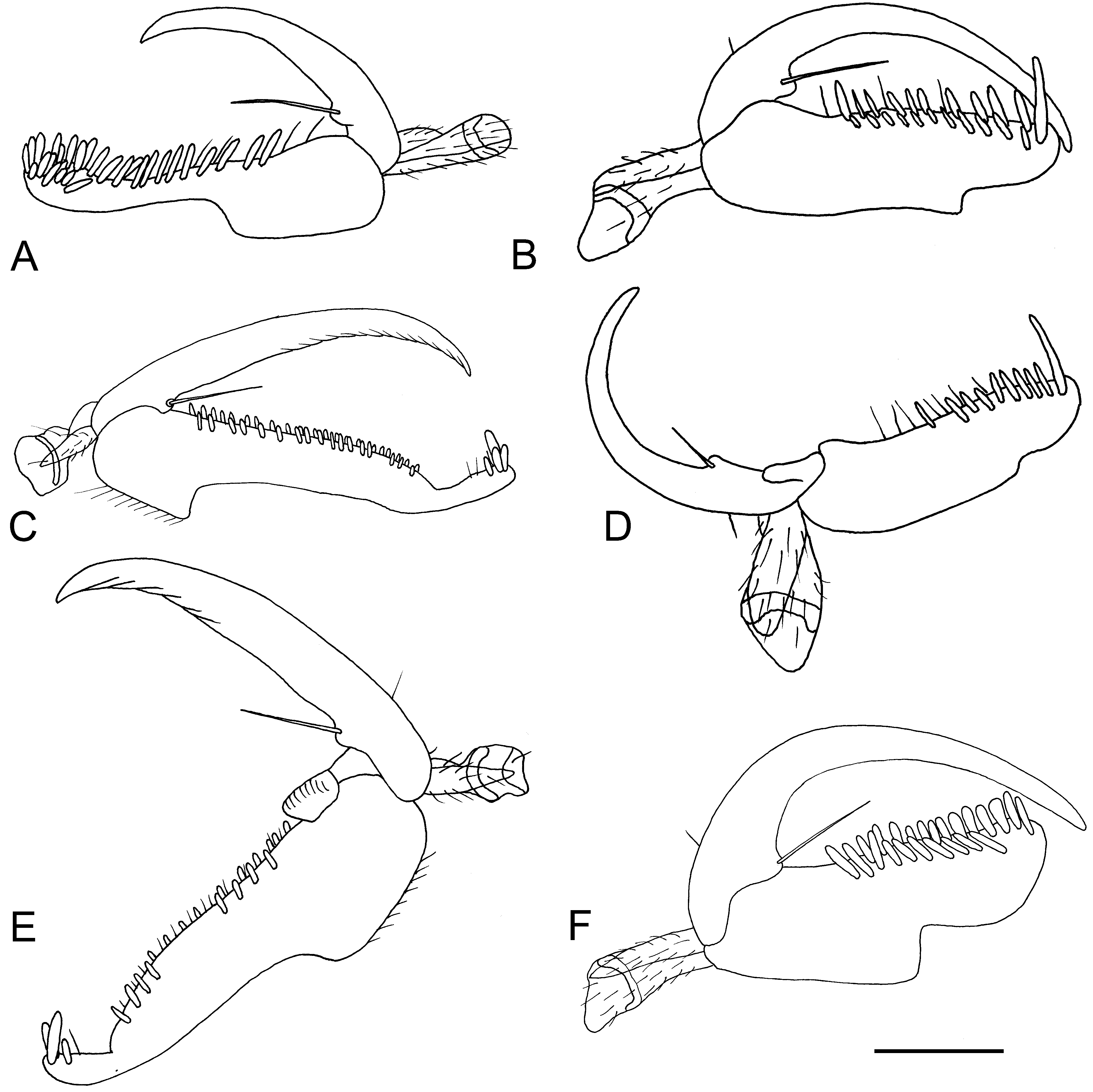
( Figs 54F View FIGURE 54 , 56A View FIGURE 56 , 57A View FIGURE 57 )
Chelogynus kivuanus Benoit 1951c: 13 (♀; the ♂ described by Benoit (1951c: 15) has 2 longitudinal keels on propodeal decliv- ity (they are absent in the ♀), so that it was described as Anteon agile Olmi 1984 ).
Anteon kivuanum Olmi 1984: 363 ; Olmi & van Harten 2006: 322; Azevedo et al. 2010: 878; Olmi et al. 2015: 346; 2016: 63.
Description. ♀. Fully winged; body length 2.7–3.9 mm. Head black, except mandible testaceous (in specimen from South Africa, 1.5 km E Mtunzini, anterior margin of clypeus testaceous); antenna black, except antennomeres 1–5 brown or testaceous (in specimen from South Africa, 1.5 km E Mtunzini, antenna testaceous, except antennomeres 7–10 darkened); mesosoma and metasoma black (in specimen from South Africa, 1.5 km E Mtunzini, metasoma testaceous); proleg brown or testaceous; meso- and metaleg brown-black, except tarsi testaceous and coxae partly testaceous; in specimen from South Africa, 1.5 km E Mtunzini, legs completely testaceous. Antenna clavate; antennomeres in following proportions: 12:5:6:5:5:5:5:5:5.5:7. Head granulate and reticulate rugose; frontal line present; frons with two lateral keels near orbits and directed towards antennal toruli; occipital carina complete; POL = 6; OL = 5; OOL = 8; OPL = 7; TL = 7. In some specimens (from Kenya, South Africa and Uganda) vertex behind lateral ocelli with two oblique keels connecting lateral ocelli to occipital carina. Pronotum dull, granulate and punctate, with strong transverse keels; posterior surface shorter than mesoscutum (8:20). Mesoscutum shiny, very weakly granulate (strongly granulate in specimen from South Africa, 1.5 km E Mtunzini). Notauli incomplete, very reduced, shortly present near anterior margin of mesoscutum. Mesoscutellum shiny, unsculptured. Metanotum shiny, sculptured by longitudinal keels. Metapectal-propodeal disc with strong transverse posterior keel, reticulate rugose; propodeal declivity reticulate rugose, without longitudinal keels. Forewing with two dark transverse bands; distal part of 2r-rs&Rs vein shorter than proximal part (4:6). Protarsomeres in following proportions: 6:3:4:8:25. Enlarged claw ( Fig. 57A View FIGURE 57 ) very long, longer than protarsomere 5, with proximal prominence bearing one long bristle. Protarsomere 5 ( Fig. 57A View FIGURE 57 ) curvilinear, with basal part shorter than apical part, with two rows of about 10–12 lamellae; apex of protarsomere 5 with about 10–17 lamellae. Tibial spurs 1/1/2.
♂. Fully GoogleMaps winged; body length 2.2–3.1 mm. Head GoogleMaps black, except mandible testaceous; antenna brown, except scape and pedicel testaceous; mesosoma and metasoma black; legs testaceous, except part of metacoxa and part of club of metafemur brown. Immature GoogleMaps specimens completely brown. Antennomeres GoogleMaps in following proportions: 10:4:4:4:4:4:4:4:4:5. Head GoogleMaps shiny, granulate, with slight areolae; frontal line complete; in specimens from South Africa, 29°34.56’S 30°17.40’E, and Kenya, 3.30958°S 39.96538°E, head strongly granulate and reticulate rugose; frons with or without two lateral keels near orbits and directed towards antennal toruli; occipital carina complete; POL = 7; OL = 4; OOL = 5; OPL = 2.5; TL = 3. In GoogleMaps large specimens, vertex with two oblique keels connecting lateral ocelli to occipital carina; small specimens without above oblique keels. Mesoscutum GoogleMaps shiny, unsculptured or slightly granulate or punctate, unsculptured among punctures. Notauli GoogleMaps incomplete, reaching approximately 0.25–0.40 × length of mesoscutum. Mesoscutellum GoogleMaps and metanotum shiny, unsculptured. Metapectal-propodeal GoogleMaps disc with strong transverse posterior keel, reticulate rugose; propodeal declivity without longitudinal keels, completely reticulate rugose (occasionally with left longitudinal keel). In GoogleMaps two specimens from Madagascar, 12°15.46’S 49°23.51’E, propodeal declivity with two incomplete longitudinal keels. Forewing GoogleMaps hyaline, without dark transverse bands; distal part of 2r-rs& Rs GoogleMaps vein much shorter than proximal part (3:7). Paramere GoogleMaps ( Fig. 54F View FIGURE 54 ) (figure 222 in Olmi 1984 erroneous) without distal inner pointed process and with small and broad proximal membranous process ( Fig. 54F View FIGURE 54 ); in two specimens from South Africa, Graskop GoogleMaps and 29°34.56’S 30°17.40’E, paramere with some transverse folds on their inner sides ( Fig. 56A View FIGURE 56 ); in specimens from South Africa, Ashburton GoogleMaps , 29°39’23’’S 30°27’41’’E, inner side of paramere with transverse folds or mosaic pattern. In specimens from South Africa, 32°32.033’S 25°14.267’’E, and Kenya, 3.30958°S 39.96538°E, paramere much shorter than penis. Tibial spurs 1/1/2.
Material examined. Types: ♀ holotype: DEMOCRATIC REPUBLIC OF THE CONGO: North Kivu, Virunga National Park (= Albert National Park ), Rutshuru , 1285 m, G.F. De Witte Mission, VII.1935 ( MRAC). Paratype: same locality label as holotype, 13.VII.1935 , 1♀ ( MRAC). Other material: CENTRAL AFRICAN REPUBLIC: Sangha-Mbaéré Prefecture, Dzanga-Ndoki National Park, Mabéa Bai , 21.4 km 53° NE Bayanga, 3°02.01’N 16°24.57’E, 510 m, 4.V.2001, sweep, lowland rainforest, marsh clearing, S. van Noort leg. GoogleMaps , 3♂♂ ( SAMC); Sangha- Mbaéré Prefecture, Dzanga-Ndoki National Park, 38.6 km 173° S Lidjombo , 2°21.60’N 16°03.20’E, 350 m, 23.V.2001, sweep, lowland rainforest, S. van Noort leg. GoogleMaps , 5♂♂ ( SAMC); Sangha-Mbaéré Prefecture, Reserve Spe- ciale de Forêt dense de Dzanga-Sangha , 12.7 km 326° NW Bayanga, 3°00.27’N 16°11.55’E, 420 m, 17.V.2001, sweep, lowland rainforest, S. van Noort leg. GoogleMaps , 4♂♂ ( SAMC). DEMOCRATIC REPUBLIC OF THE CONGO: Haut- Lomami, Upemba National Park , Kiamokoto-Kiwakishi , 2♀♀ ( MRAC, AMNH); Haut-Uele, Wamba Territory, Kikongo Mission , 04°16’S 17°11’E, 30.III–5.IV.2006, MT, S.L. Heydon & S.E. Stevenson leg. GoogleMaps , 1♂ ( DEUCD; Ituri Prov., Mongbwalu AGK camp, 01°56‘32.81‘‘N 30°02‘25.62‘‘E, 21-28.II.2015, 75 YPT, behind the former President Mobutu’s Doctor’s house, A. Gumovsky leg. GoogleMaps , 1♀ ( SIZK); North Kivu, Virunga National Park (= Albert Na- tional Park ), Rutshuru , 1285 m, G.F. De Witte Mission , 2♀♀ ( ISNB, AMNH); North Kivu, Virunga National Park (= Albert Nat. Park ), Mt. Ruwenzori, Bombi River, Kakalari River , 1♀ ( MRAC); North Kivu, Virunga National Park (= Albert Nat. Park ), Tshiaberimu, Talia N River, Mbulikerere River , 1♀ ( MRAC); North Kivu, Virunga Na- tional Park (= Albert Nat. Park ), Mt. Hoyo , 2♀♀ ( MRAC, AMNH); North Kivu, Virunga National Park (= Albert Nat. Park ), Kyandolire, Bomboka , 1♀ ( MRAC); South Kivu, Lwiro River , 47 Km N of Bukavu, 1650 m , 1♀ ( CAS). KENYA: Coast Prov., Arabuko-Sokoke Forest , 3.30958°S 39.96538°E, 80 m, 22.IX–6.X.2014, MT in bush outside forest, R. Copeland leg. GoogleMaps , 1♂ ( NMK); Coast Prov., Kaya Kinondo , 4.39382°S 39.54567°E, 10 m, 22.VIII–5.IX.2011, indigenous forest, MT, coral rag canopy forest, R. Copeland leg. GoogleMaps , 1♂ ( NMK); Western Prov., Kakamega District, Kakamega Forest, Kisere Forest , Calebs Campground , 00°22.175’N 34°53.297’E, 1580 m, 2002, KE 1633, Manfred Kraemer leg. GoogleMaps , ex Michael von Tschirnhaus collection , 1♀ ( MOLC). MADAGASCAR: Antsiranana, Sakalava Beach , 12°15.46’S 49°23.51’E, 10 m, 15.II–6.III.2001, dwarf littoral forest, MT, across sandy trail, MA-01-04B-03, M.E. Irwin & R. Harin’Hala leg. GoogleMaps , 3♂♂ ( CAS); Antsiranana, Montagne d’Ambre National Park , 12°31.13’S 49°10.45’E, 1125 m, 21–26.IV.2001, MT, MA-01-01D-08, R. Harin’Hala leg. GoogleMaps , 1♂ ( CAS); Antsiranana, Diana Re- gion, Orangea dry forest, Ramena , Baie de dune, 900m E of Camp Minier, 1–8.VI.2011, 12°13.97’ S 49°21.99’E, M. Irwin, R.Harin’Hala leg. GoogleMaps , MT, dry forest, elev. 152 m, MG-62-25, 1♂ ( CAS); Fianarantsoa, Ranomafana Na- tional Park, Vohiparara , at broken bridge, 21°13.57’S 47°22.19’E, 4–12.II.2002, 1110 m, MT, high altitude rainforest, R. Harin’Hala leg. GoogleMaps , MA-02-09A-15, 3♂♂ ( CAS); same locality label, 21–28.I.2002 GoogleMaps , 1♂ ( CAS); Fianarantsoa, Ranomafana National Park, Belle Vue at Talatakely , 21°15.99’S 47°25.21’E, 1020 m, 14–22.VII.2002, MT, secondary tropical forest, R. Harin’Hala leg. GoogleMaps , MA-02-09C-35, 1♂ ( MOLC); same locality label, 2–10.I.2002, MA-02-09C- 10 GoogleMaps , 1♂ ( CAS); same locality label, 16.X–8.XI.2001, MA-02-09C-01 GoogleMaps , 2♂♂ ( CAS); Fianarantsoa, Ranomafana Na- tional Park , radio tower at forest edge, 21°15.05’S 47°24.43’E, 1130 m, 4–12.III.2002, MT, mixed tropical forest, R. Harin’Hala leg. GoogleMaps , MA-02-09B-19, 1♂ ( CAS); same locality label, 12–19.II.2002, MA-02-09B-16 GoogleMaps , 1♂ ( CAS); same locality label, 15–21.XII.2001, MA-02-09B-07 GoogleMaps , 2♂♂ ( CAS); Fianarantsoa, Ranomafana , JIRAMA water works, 21°14.91’S 47°27.13’E, 690 m, 21–24.XII.2001, MT, near river, R. Harin’Hala leg. GoogleMaps , MA-02-09D-08, 1♂ ( MOLC); Fianarantsoa, Ambalagoavy Nord Forest, Ikongo, Ambatombe , 21°49.39’S 47°20.20’E, 625 m, XI.2000, MT, Harin’Hala R. & M.E. Irwin leg. GoogleMaps , MA- 01-12-01, 1♂ ( CAS); Fianarantsoa, Vevembe Forest , 66.6 km 293° WNW Farafangana, 22°47.28’S 47°10.55’E, 600 m, 23.IV.2006, MT, rainforest transitioning to montane forest, B.L. Fisher et al. leg., BLF14118 GoogleMaps , 1♂ ( CAS); Toamasina, Ankerana , 18°24.37’S 48°49.08’E, 1108 m, 22–27.I.2012, MT, rainforest, B.L. Fisher et al. leg., BLF27982 GoogleMaps , 1♂ ( CAS); Toamasina, Zahamena National Park, Tetezambatana Forest, mear junction of Nosivola and Manakambahiny Rivers , 17°44‘35‘‘S 48°43‘46‘‘E, 860 m, 18–19.II.2009, rainforest, MT, BLF21972, B.L. Fisher et al. leg GoogleMaps ., 2♂♂ ( CAS); Toliara, Forêt de Kirindy , 15.5 km 64° ENE Ma- rofandilia, 20°04.09‘S 044°39.38‘E, 10–17.XII.2008, B.L. Fisher, MT, tropical dry forest, el 30 m, BLF18285_58 GoogleMaps , 1♂ ( CAS); Toliara, Forêt de Kirindy , 15.5 km 64° ENE Marofandilia, 20°04.07’S 044°39.34’E, 26.XI–37. XII.2008, B.L. Fisher, MT, tropical dry forest, el 30 m, BLF18284_56 GoogleMaps , 1♂ ( MOLC); Toliara, Tsifota, 20 km N Manombo , 1 km E of Tsifota village, 22°49.08’S 43°22.36’E, 15 m, 29.XII.2008 – 8.I.2009, MT, spiny forest, M. Itwin, R. Harin’Hala leg. GoogleMaps , MG-48-09, 1♂ ( CAS). SOUTH AFRICA: Eastern Cape, Somerset East , 2♀♀ ( NHMUK, AMNH); Port St. Johns , XI.1923, R.E. Turner leg. , 1♂ ( NHMUK); Eastern Cape, Pearston , Plains of Camdeboo Game Re- serve, 32°32.033’S 25°14.267’E, 969 m, 30.X.2009 – 22.II.2010, MT, Camdeboo Escarpment Ticket, S. van Noort leg. GoogleMaps , 2♂♂ ( SAMC); Eastern Cape, Asante Sana Game Reserve , 32°14.990’S 24°55.962’E, 2183 m, 29.X.2009 – 23.II.2010, MT, Karoo Escarpment Grassland, S. van Noort leg. GoogleMaps , 1♂ ( SAMC); Eastern Cape, Winterberg, The Hoek Farm , 32°21.260’S 26°23.001’E, 1879 m, 9.IV–26.VII.2010, YPT, Amathole Mistbelt Grassland, S. van Noort leg. GoogleMaps , 1♂ ( SAMC); same locality label, 3.IX–30.X.2009 GoogleMaps , 1♂ ( SAMC); Kwazulu-Natal, Pietermaritzburg , 2♂♂ ( AEIC, AMNH); Kwazulu-Natal, 1.5 Km E Mtunzini, Umlalazi Nature Reserve , 1♂ ( PMA); Kwazulu-Natal, 1.5 km E Mtunzini, Umlalazi Nature Reserve, 2831 Dd, II.1979, Indigenous forest , MT, R.M. Miller leg. , 1♀ ( PMA); Kwa- zulu-Natal, Cedara , 1♀ ( SANC); Kwazulu-Natal, Pietermaritzburg, Hilton , garden, 6–14.III.2005, YPT, V. Kolyada leg. , 1♂ ( NMSA); Kwazulu-Natal, Winterskloof , 29°34.56‘S 30°17.40‘E, 1085 m, 20.IV–1.IX.2007, MT, M. Mo- stovski leg GoogleMaps ., 1♂ ( NMSA); Kwazulu-Natal, Royal Natal National Reserve, Gudu Forest , 28°40.90‘S 28°55.78‘E, 1680–1730 m, 13.XII.2005 – 28.I.2006, MT, M. Mostovski leg. GoogleMaps , 2♂♂ ( NMSA); Kwazulu-Natal, Ashburton , 29°39‘23‘‘S 30°27‘41‘‘E, 24.XI–8.XII.2005, MT, G.Whiteley leg. GoogleMaps , 1♀ ( DJBC); same locality label, 29.X–9.XI.2005 GoogleMaps , 1♂ ( DJBC); same locality label, 15–30.III.2006 GoogleMaps , 1♂ ( MOLC); same locality label, 24.XI–8.XII.2005 GoogleMaps , 8♂♂ (7 in DJBC, 1 in MOLC); same locality label, 6.I–1.II.2006 GoogleMaps , 1♂ ( DJBC); same locality label, 8.XII.2005 – 6.I.2006 GoogleMaps , 4♂♂ ( DJBC); same locality label, 9–24.XI.2005 GoogleMaps , 11♂♂ ( DJBC); Limpopo, 30 km E Nylstroom , 1♀ ( PMA); Mpuma- langa, E Transvaal , 11 km SE Pilgrims Rest, 1400 m , 1♂ ( PMA; Mpumalanga, Graskop , 1500 m , 1♂ ( PMA); Mpumalanga, Krüger National Park , Skukuza Malt ., 1♀ ( PMA); Western Cape, Constantiaberge, 34°02.5‘S 18°23.5‘E, 640 m, above road to mast overlooking Hout Bay , 14–23.III.1994, Mesic Mountain Fynbos, MT, SAM- HYM-PO03801, S. van Noort leg. GoogleMaps , 1♂ ( SAMC); Western Cape, Cape Town, above Tokai Forest, Constantiaberge , above Donkerboskloof , 34°02‘N 18°23.5‘E, 460 m, 17–27.III.1995, Site 2, Mesic Mountain Fynbos, Protea coronata dominated, MT, SAM-HYM-PO13731, S. van Noort leg. GoogleMaps , 1♂ ( SAMC); same locality label, 10–17.III.1995, SAM-HYM-PO13722 GoogleMaps , 1♂ ( SAMC); same locality label, 6–13.XII.1994, SAM-HYM-PO13730 GoogleMaps , 1♂ ( SAMC); same locality label, Protea dominated, 9–15.II.1994, SAM-HYM-PO05920, SAM-HYM-PO03791, SAM-HYM- PO05921 GoogleMaps , 5♂♂ ( SAMC); same locality label, Protea dominated, 25.I–2.II.1994 GoogleMaps , 1♂ ( SAMC); Western Cape, Ce- res, 2–21.III.1921, R.E. Turner leg. , 1♂ ( NHMUK); Western Cape, Kirstenbosch , 1♂ ( AEIC); Western Cape, Stel- lenbosch, Jonkershoek Reserve , 1♂ ( PMA); Western Cape, Cape of Good Hope Nat. Reserve, Da Gama Peak, 34°21’S 18°29’E, 28–31.III.1995, MT, Old Mesic Mountain Fynbos, SAM-HYM-PO13726, S. van Noort leg. GoogleMaps , 1♂ ( SAMC); Western Cape, Hermanus, Fernkloof Nat. Reserve, Mosselberg , 60 m, 12.III.1995, Mesic Mountain Fynbos, MT, SAM-HYM-PO13726, S. van Noort leg. , 1♂ ( SAMC); Western Cape, Walker Bay Nature Reserve , 34°27.41’S 19°21.39’E, 11.VIII–6.IX.1997, S. van Noort leg. GoogleMaps , 22♂♂ ( SAMC); same locality label, IX–XII.1997, MT, S. van Noort leg. GoogleMaps , 7♂♂ ( SAMC); same locality label, 17–31.V.1997, MT, S. van Noort leg. GoogleMaps , 43♂♂ ( SAMC); Western Cape, Walker Bay Nature Reserve, 34°27.414’S 19°21.393’E, 21.II–21.III.1998, MT, South Coast Strandveld , 57 m, S. van Noort leg. GoogleMaps , 2♂♂ ( SAMC); same locality label, 18.IV–16.V.1998 GoogleMaps , 3♂♂ ( SAMC); Western Cape, Die Dam, C. 23.II.2006, B. 24.II.2006, M. Olmi reared from a nymph of Iassomorphus drakensteini (Naudé) , 1♀ ( MOLC); Western Cape, Fynbos Estate, Dragonridge , 33°34.092’S 18°47.680’E, 635 m, 8.II–2.IV.2010, MT, Boland Granite Fynbos, S. van Noort leg. GoogleMaps , 1♂ ( SAMC); same locality label, 28.IX–28.XII.2010, GRA09-FYN1-M05 GoogleMaps , 3♂♂ ( SAM); Western Cape, Grootvadersbosch Nature Reserve , 33°58.888’S 20°48.885’E, 454 m, 29.III– 23.VII.2010, MT, South Langeberg Sandstone Fynbos, S. van Noort leg. GoogleMaps , 2♂♂ ( SAMC); same locality label, 26.X.2010 – 25.I.2011, GVB10-FYN1-M08 GoogleMaps , 2♂♂ ( SAMC); Western Cape, Koeberg Nature Reserve , 33°37.622’S 18°24.259’E, 20.III–17.IV.1998, MT, West Coast Strandveld, S. van Noort leg. GoogleMaps , 1♂ ( SAMC); same locality label, 20.II–20.III.1998 GoogleMaps , 5♂♂ ( SAMC); same locality label, 17.IV–15.V.1998 GoogleMaps , 1♂ ( SAMC); same locality label, 3– 31.X.1997 GoogleMaps , 5♂♂ ( SAMC); Western Cape, Banghoek Valley, Dwarsriviershoek Farm , 33°56.232’S 18°57.711’E, 410 m, 25.IV–16.V.2013, MT, Mesic Mountain Fynbos, BH 12-FYN3-M08, S. van Noort leg. GoogleMaps , 2♂♂ ( SAMC). UGANDA: Western Region , Kibale Forest, Kanyawara , 1♂ ( RNHL); Western Region, Kibale National Park, Kan- yawara Makerere University Biological Field Station , 0°34.390’S 30°21.658’E, 1587 m, 4–26.VIII.2008, YPT, primary mid-altitude rainforest, near stream, S. van Noort leg. GoogleMaps , 1♀ ( SAMC); same locality label, 0°33.836’N 30°21.700’E, 1523 m, 4–26.VIII.2008, YPT, primary mid-altitude rainforest, S. van Noort leg. GoogleMaps , 2♀♀, 2♂♂ ( SAMC); same locality label, 0°33.891’N 30°21.468’E, 1506 m, 4–26.VIII.2008, YPT, primary mid-altitude rainforest, S. van Noort leg. GoogleMaps , 1♀, 1♂ ( SAMC); same locality label, 0°33.996’S 30°21.262’E, 1495 m, 29–31.VII.2005, YPT, second- ary mid-altitude rainforest, S. van Noort leg. GoogleMaps , 1♀, 1♂ ( MOLC); same locality label, 0°33.784’S 30°21.617’E, 1500 m, 12–26.VIII.2008, MT, primary mid-altitude rainforest, S. van Noort leg. GoogleMaps , 1♂ ( SAMC). YEMEN: Ar Rujum , 16.X.2000 – 15.I.2001, 15.I–9.IV.2001, MT, A. van Harten , 5♂♂ ( MOLC) .
Hosts. Cicadellidae ( Guglielmino et al. 2013) : in South Africa: Iassomorphus drakensteini (Naudé) .
Distribution. Central African Republic, Democratic Republic of the Congo, Kenya, Madagascar, South Africa, Uganda, Yemen.
Remarks. Anteon fiorii Olmi is very similar to A. kivuanum (Benoit) . The only difference is in respect of the colour: mostly black in kivuanum , mostly testaceous-reddish in fiorii . The only known male is that of A. kivuanum . Both species were collected in South Africa, Ashburton, by a temporally extensive survey using Malaise traps. The chelae of the two species are alike. The probability that the two species are conspecific is very high.


| MRAC |
Musée Royal de l’Afrique Centrale |
| SAMC |
Iziko Museums of Cape Town |
| AMNH |
American Museum of Natural History |
| SIZK |
Schmaulhausen Institute of Zoology |
| CAS |
California Academy of Sciences |
| NMK |
National Museums of Kenya |
| NHMUK |
Natural History Museum, London |
| AEIC |
American Entomological Institute |
| PMA |
Provincial Museum of Alberta |
| SANC |
Agricultural Research Council-Plant Protection Research Institute |
| NMSA |
KwaZulu-Natal Museum |
| SAM |
South African Museum |
No known copyright restrictions apply. See Agosti, D., Egloff, W., 2009. Taxonomic information exchange and copyright: the Plazi approach. BMC Research Notes 2009, 2:53 for further explanation.
|
Kingdom |
|
|
Phylum |
|
|
Class |
|
|
Order |
|
|
Family |
|
|
Genus |
Anteon kivuanum (Benoit, 1951)
| Olmi, Massimo, Copeland, Robert S. & Noort, Simon Van 2019 |
Anteon kivuanum
| Azevedo, C. O. & Madl, M. & Olmi, M. 2010: 878 |
| Olmi, M. & van Harten, A. 2006: 322 |
| Olmi, M. 1984: 363 |
Chelogynus kivuanus
| Benoit, P. L. G. 1951: 13 |
| Benoit, P. L. G. 1951: 15 |