
Deinodryinus rusticus Olmi, 2004
|
publication ID |
https://doi.org/ 10.11646/zootaxa.4630.1.1 |
|
publication LSID |
lsid:zoobank.org:pub:8D375836-CCBA-473C-836F-6ABD44B4F881 |
|
persistent identifier |
https://treatment.plazi.org/id/03E987E2-FF58-2AB2-FF3E-D121FC98F8AC |
|
treatment provided by |
Plazi |
|
scientific name |
Deinodryinus rusticus Olmi, 2004 |
| status |
|
23. Deinodryinus rusticus Olmi, 2004
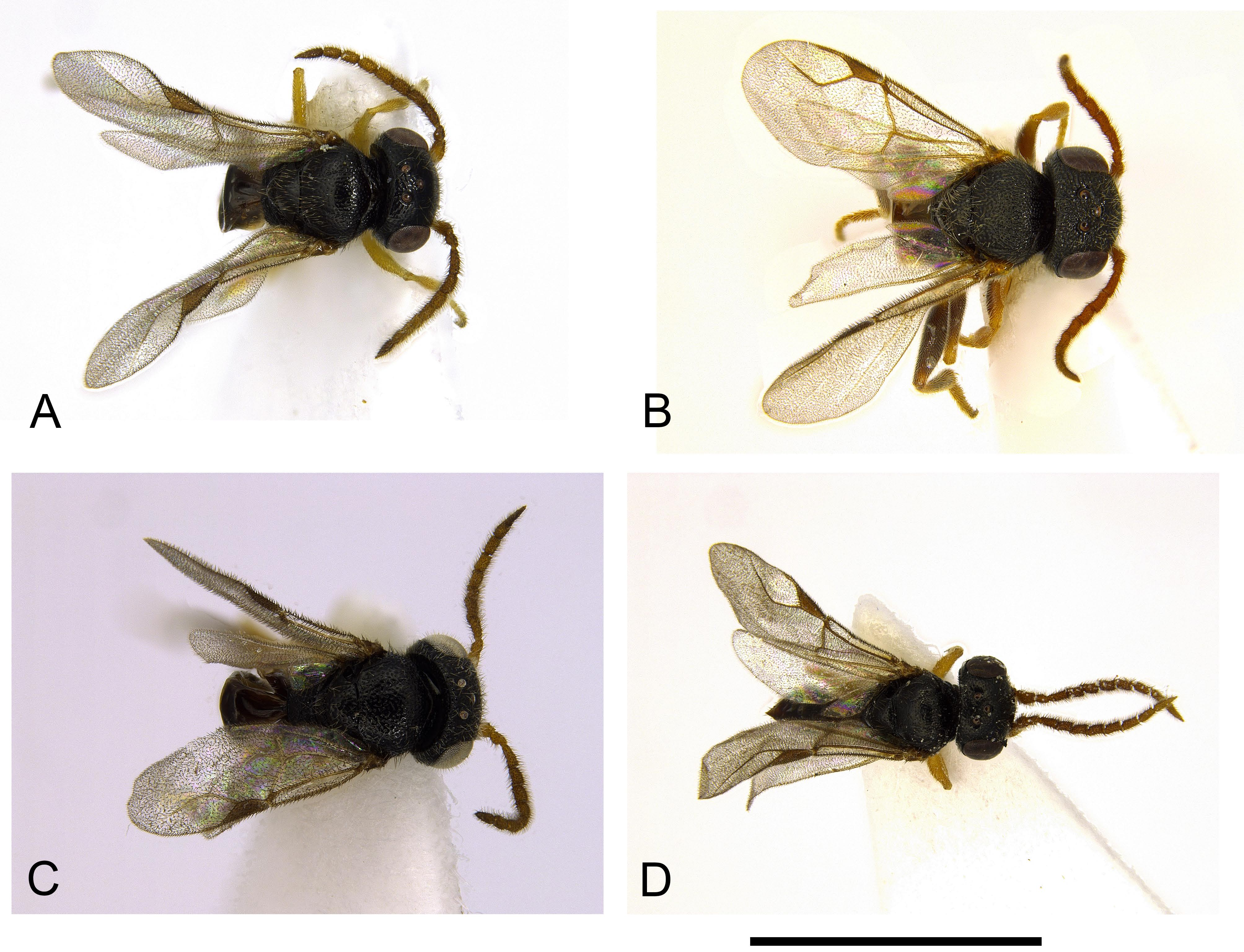
( Figs 88 View FIGURE 88 A–D, 95B)
Deinodryinus rusticus Olmi 2004d: 88 ; Azevedo et al. 2010: 882; Guglielmino & Olmi 2015: 251 View Cited Treatment . Description. ♂ ( Fig. 95B View FIGURE 95 ). Fully winged; body length 2.9–4.6 mm (holotype 2.9 mm); paratypes from Madagascar, 18°28.24’S 47°57.36’E, longer than holotype (3.8–4.6 mm). Colour of holotype: head black, except mandible testaceous; antenna testaceous; mesosoma and metasoma black; legs testaceous, except coxae, clubs of femora and part of metatibia brown; paratypes from Madagascar, 18°28.24’S 47°57.36’E, with legs completely testaceous, except for brown basal spot on metacoxa. Usually large specimens with legs totally or mostly testaceous, small specimens with legs mostly brown. Antenna filiform, with setae shorter than breadth of antennomeres; antennomeres in following proportions: 11:4:11:7:8:7:6.5:6.5:7:9. Head shiny, strongly punctate, unsculptured among punctures (head punctures very strong; head almost rugose, mainly on frons; in many specimens from Madagascar frons reticulate rugose); vertex without two oblique keels from lateral ocelli to occipital carina; frontal line usually almost complete, missing only in front of anterior ocellus; frontal line occasionally only visible in anterior half of frons; occipital carina complete; POL = 8; OL = 4; OOL = 6.5; OPL = 9; TL = 5; in some specimens OPL shorter than OOL, or approximately as long as OOL. Mesoscutum shiny, as sculptured as head. Notauli incomplete, usually reaching approximately 0.5–0.6 × length of mesoscutum; rarely notauli reaching 0.8–0.9 × length of mesoscutum. Mesoscutellum shiny, punctate, unsculpured among punctures. Metanotum shiny, unsculptured. Metapectal-propodeal disc dull, reticulate rugose, without transverse posterior keel; propodeal declivity almost completely reticulate rugose, with small central smooth and shiny area, without longitudinal or transversal keels; occasionally propodeal declivity with two tracks of longitudinal keels and median area completely dull and reticulate rugose. Forewing hyaline, without dark transverse bands; distal part of 2r-rs&Rs vein slightly longer than proximal part (13:12), or as long as proximal part. Paramere ( Fig. 88A View FIGURE 88 ) with slender and long distal inner branch (branch showing mosaic sculpture ( Fig. 88A View FIGURE 88 ) in holotype and in specimen from Madagascar, 12°17.17’S 49°22.00’E; mosaic sculpture not visible in few paratypes from Madagascar, 18°28.24’S 47°57.36’E and 24°39.13’S 43°59.48’E ( Figs 88B, C View FIGURE 88 ); in almost all specimens inner side of paramere with large area sculptured by numerous papillae. In specimen from Madagascar, 24°14.26’S 46°17.16’E, distal inner branch very short ( Fig. 88D View FIGURE 88 ). Tibial spurs 1/1/2.
♀. Unknown.
Material examined. Types: ♂ holotype: MADAGASCAR: Mahajanga, Ankoririka Reserve, 10.6 km 13° NE of Tsaramandroso , 16°16.2’S 46°2.55’E, 210 m, 9–14.IV.2001, MT, tropical dry forest, Fisher, Griswold et al. leg., BLF 3665 ( CAS). GoogleMaps Paratypes: MADAGASCAR: Antananarivo, 11.5 km 47° SSE of Anjozorobe, 3 km 41° NE of Andranomay, 18°28.24’S 47°57.36’E, 1300 m, 5–13.XII.2000 GoogleMaps , MT, montane rainforest, Fisher , Griswold et al. leg., BLF 2375 , 6♂♂ (4 in CAS, 2 in MOLC). Other material: MADAGASCAR: Antananarivo, 46 km NE of Ankazobe, Ambohitantely , 18°11.88’S 47°16.89’E, 700 m, 15.X–1.XI.2004 GoogleMaps , MT, sclerophyl forst, M. Irwin & R. Harin’Hala leg., MA-27-19, 1♂ ( MOLC); Antsiranana, 3 km W of Sakalava Beach , white dunes, 12°17.17’S 49°22.00’E, 40 m, 27–30.I.2001 GoogleMaps , MT, MA- 01-03-03, M.E. Irwin, E.I. Schlinger & R. Harin’Hala leg., 1♂ ( CAS); same locality label, 21–23.I.2001 GoogleMaps ,MA- 01-03-01, 3♂♂ ( CAS); Antsiranana, Sakalava Beach , 12°15.46’S 49°23.51’E, 10 m, 27.IV–13.V.2001 GoogleMaps , dwarf littoral forest, MT, across sandy trail, MA-01-04B-08, M.E. Irwin & R. Harin’Hala leg., 1♂ ( CAS); Antsiranana, Binara Forest , 7.5 km 230° SW Daraina, 13°15.18’S 49°37.00’E, 375 m, 1.XII.2003 GoogleMaps , MT, tropical dry forest, B.L. Fisher leg., BLF9557, 7♂♂ ( CAS); Antsiranana, SAVA Region, Vohemar District, Antsahabelela rain forest, 9 km SW Daraina, Binara , 13°15.03’S 49°37.00’E, 182 m, 17–24.XI.2010 GoogleMaps , MT, in humid forest, M. Irwin, R. Harin’Hala leg., MG-58-07, 1♂ ( CAS); same locality label, 8–15.XII.2010 GoogleMaps , MG-58-10, 1♂ ( CAS); same locality label, 11–19.I.2011 GoogleMaps , MG-58-15, 1♂ ( CAS); Antsiranana, SAVA Region, Vohemar District, Andranotsimaty dry forest, 9 km NE Daraina, 13°10.17’S 49°42.04’E, 90 m, 14–21.XI.2010 GoogleMaps , MT, dry dense forest, M. Irwin, R. Harin’Hala leg., MG-57-07, 1♂ ( CAS); same locality label, 19–26.XII.2010 GoogleMaps , MG-57-12, 2♂♂ ( CAS, MOLC); same locality label, 14–21.II.2011 GoogleMaps , MG-57-19, 1♂ ( CAS); same locality label, 11-18.IV.2011 GoogleMaps , MG-57-27, 3♂♂ (2 in CAS, 1 in MOLC); Antsiranana, Diana Region, Orangea dry forest, Ramena , Baie de dune, 900 m E of Camp Minier , 1–8.VI.2011 , 12°13.97’S 49°21.99’E, M. Irwin, R.Harin’Hala leg., MT, dry forest, elev. 152 m, MG- 62-25, 1♂ ( CAS); same locality label, 12–19.I.2011 , MG-62-05, 1♂ ( CAS); Antsiranana, Ambato Forest , 26.6 km 33° NE Ambanja, 13°27.52’S 48°33.06’E, 150 m, 8.XII.2004 GoogleMaps , MT, rainforest, B.L. Fisher leg., BLF11518 , 1♂ ( CAS); Antsiranana, Montagne d’Ambre National Park , 12°31.13’S 49°10.45’E, 1125 m, 12–14.V.2001 GoogleMaps , MT, MA- 01-01D-10, R. Harin’Hala leg., 3♂♂ ( CAS); same locality label, 14–30.V.2001 GoogleMaps , R. Harin’Hala leg., MA-01-01D- 11, 1♂ ( CAS); Antsiranana, Orangea , 3 km E of Ramena near fort, 12°14.49’S 49°22.17’E, 65 m, 23–27.I.2001 GoogleMaps , MT, littoral forest on sand, MA- 01-05-02, M.E. Irwin, E.I. Schlinger & R. Harin’Hala leg., 1♂ ( CAS); Fianarantsoa, Ranomafana National Park , radio tower at forest edge, 21°15.05’S 47°24.43’E, 1130 m, 16.X–8.XI.2001 GoogleMaps , MT, mixed tropical forest, R. Harin’Hala leg., MA-02-09B-01, 3♂♂ (2 in CAS, 1 in MOLC); same locality label, 4– 12.III.2002 GoogleMaps , 1♂ ( CAS); same locality label, 21°15.05’S 47°24.43’E, 1130 m, 15–25.VII.2002 GoogleMaps , MA-02-09B-35, 1♂ ( CAS); same locality label, 24.V–4.VI.2002 GoogleMaps , MA-02-09B-30, 5♂♂ ( CAS); same locality label, 7–17.V.2003 GoogleMaps , MA- 02-09B-60, 1♂ ( CAS); same locality label, 27.VI–7.VII.2003 GoogleMaps , MA-02-09B-65, 1♂ ( CAS); Fianarantsoa, Rano- mafana National Park, Belle Vue at Talatakely , 21°15.99’S 47°25.21’E, 1020 m, 19–26.II.2002 GoogleMaps , MT, secondary tropical forest, R. Harin’Hala leg., MA-02-09C-17, 3♂♂ ( CAS); same locality label, 15–28.V.2003 GoogleMaps , MA-02-09C- 61, 1♂ ( MOLC);same locality label, 28.IV–5.V.2002 GoogleMaps , MA-02-09C-27, 1♂ ( CAS);same locality label 22–28.XI.2001 GoogleMaps , MA-02-09C-04, 2♂♂ ( CAS, MOLC); same locality label, 16.X–8.XI.2001 GoogleMaps , MA-02-09C-01, 1♂ ( CAS); Fianarant- soa, Ranomafana National Park, Vohiparara , 21°13.57’S 47°22.19’E, at broken bridge, 1110 m, 15–25.VII.2002 GoogleMaps , MT, high altitude rainforest, R. Harin’Hala leg., MA-02-09A-35, 5♂♂ (3 in CAS, 2 in MOLC); same locality label, 14–21.I.2002 GoogleMaps , 2♂♂ ( CAS, MOLC); same locality label, 15–21.XII.2001 GoogleMaps , MA-02-09A-07, 1♂ ( CAS), 1 gynander specimen ( MOLC); same locality label, 26–31.III.2002 GoogleMaps , MA-02-09A-22, 3♂♂ ( CAS); Fianarantsoa, Ranomafana National Park, Vohiparara , 21°13.67’S 47°22.19’E, at broken bridge, 1110 m, 25.VII–3.VIII.2002 GoogleMaps , MT, high altitude rainforest, R. Harin’Hala leg., MA-02-08A-36, 1♂ ( CAS); Fianarantsoa, Befotaka-Midongy National Park, Papango 27.7 km S Midongy-South Mt. Papango, 23°50.07’S 46°57.49’E, 940 m, 13–19.XI.2006 GoogleMaps , MT, B.L. Fisher et al. leg., BLF14774 , 1♂ ( CAS); Mahajanga, Namoroka National Park , 16.9 km 317° NW Vilanandro, 16°24.24’S 45°18.36’E, 100 m, 12–16.XI.2002 GoogleMaps , MT, tropical dry forest, Fisher, Griswold et al. leg., BLF 6581, 6♂♂ ( CAS); Mahajanga, Namoroka National Park , 16.40494S 45.31294E, 21–31.X.2016 GoogleMaps , MT, C. Villemant leg., 1♂ ( MNHN); Mahajanga, Sofia District , 45 km S Antsohihy, 5 km W of Anjiamangirana, elev 97 m, 5–8 May 2011 , 15° 09.42’S 47° 47.05’E, M.Irwin, R.Harin’Hala, MT, Analagnambe dry degraded forest, MG-61-11, 1♂ ( CAS); same locality label, 2–6.I.2011 , MG-61-04, 1♂ ( CAS); Mahajanga, Beanka Forest Reserve , 50.2 km E Maintirano, 18°01’35’’S 44°03’02’’E, 250 m, 19–26.X.2009 GoogleMaps , tropical dry forest on tsingy, MT, B.L. Fisher et al. leg., BLF22787 , 2♂♂ ( CAS); Mahajanga, Analamanitra Forest , 14 km NE Misinjo, 15°55’S 45°57’E, 65 ft., 23–30.X.2007 GoogleMaps , MT, dense dry forest, M. Irwin, R. Harin’Hala leg., MG-38-06, 1♂ ( CAS); same locality label, 12–19.II.2008 GoogleMaps , MG-38-18, 1♂ ( CAS); Mahajanga, Bemarivo Special Reserve , 23.8 km 223° SW Besalampy, 16°55.30’S 44°22.06’E, 19– 23.XI.2002 GoogleMaps , 30 m, sifted litter (leaf mold, rotten wood), in tropical dry forest, Fisher, Griswold et al. leg., BLF6693, 4♂♂ ( CAS); Mahajanga, Ankarafantsika National Park, Tsimaloto Forest , 18.3 km 49° NE Tsaramandroso, 16°13’41’’S 46°08’37’’E, 135 M, 2–8.IV.2001 GoogleMaps , MT, tropical dry forest, Fisher, Griswold et al. leg., BLF3600, 5♂♂ (4 in CAS, 1 in MOLC); Mahajanga, Besalampy District, Marofototra palm forest, 17 km W of Besalampy, 16°43.30’S 44°25.42’E, 35 ft., 24.IX–1.X.2007 GoogleMaps , MT, palm trees on sand, M. Irwin, R. Harin’Hala leg., MG-42B-01, 1♂ ( CAS); same locality label, Marofototra dry forest, 170 ft., 19–26.XI.2007 GoogleMaps , dry wash in forest, MG-42A-09, 1♂ ( CAS); same locality label, Marofototra dry forest, 170 ft., 1–8.X.2007 GoogleMaps , dry wash in forest, MG-42A-02, 1♂ ( MOLC); Mahajanga, Tsingy de Bemaraha National Park, 3.4 km 93° E Bekopaka, Tombeau Vazimba , 19°08.31’S 44°49.41’E, 50 m, 6–10.XI.2001 GoogleMaps , MT, tropical dry forest, Fisher, Griswold et al. leg., BLF 4233, 1♂ ( CAS); Toama- sina, Andasibe National Park , 18°55.58’S 48°24.47’E, botanic garden near entrance to park, 1025 m, 16–23.XI.2001 GoogleMaps , MT, tropical forest, R. Harin’Hala leg., MA-01-08B-20, 1♂ ( CAS); Toliara, Mahafaly Plateau , 6.2 km 74° ENE of Itampolo, 24°39.13’S 43°59.48’E, 80 m, MT, spiny forest thicket, 21–25.II.2002 GoogleMaps , Fisher, Griswold et al. leg., BLF5759 , 2♂♂ ( CAS, MOLC); Toliara, Andohahela Nat. Park, Manantalinjo Forest, 33.6 km 63° ENE Amboasary, 7.6 km 99° E Hazofotsy , 24°49.1’S 46°36.36’E, 150 m, 12–16.I.2002 GoogleMaps , MT, spiny forest thicket, Fisher, Griswold et al. leg., BLF 4811, 15♂♂ (13 in CAS, 2 in MOLC); Toliara, Beza Mahafaly Reserve , parcelle I near research sta- tion, 23°41.19’S 44°35.46’E, 165 m, 1–8.II.2002 GoogleMaps , MT, dry deciduous forest, R. Harin’Hala leg., MA-02-14A-14, 2♂♂ ( CAS, MOLC); same locality label, 25.XII.2001 – 2.I.2002 GoogleMaps , 1♂ ( CAS); same locality label, 9–20.IX.2002 GoogleMaps , 3♂♂ (2 in CAS, 1 in MOLC); same locality label, 23.III–2.IV.2003 GoogleMaps , 1♂ ( CAS); same locality label, 29.III–10.IV.2002 GoogleMaps , 1♂ ( CAS); Toliara, Beza Mahafaly Reserve, parcelle II near Bellevue , 23°41.39’S 44°34.53’E, 180 m, 15.X– 10.XI.2001 GoogleMaps , MT, spiny forest, M.E. Irwin, F.D. Parker & R. Harin’Hala leg., MA-02-14B-01, 3♂♂ (1 in CAS, 2 in MOLC); Toliara, Andohahela National Park, Tsimelahy , parcelle II, 24°56.21’S 46°37.60’E, 180 m, 16–17.XII.2002 GoogleMaps , MT, transitional forest, M. Irwin, F. Parker & R. Harin’Hala leg., MA- 02-20-09, 1♂ ( CAS); same locality label, 10–20.VII.2003 GoogleMaps , 2♂♂ ( CAS); Toliara, Mikea Forest , NW of Manombo, 22°54.22’S 43°28.53’E, 30 m, 20– 27.XI.2001 GoogleMaps , MT, deciduous dry forest, R. Harin’Hala leg., MA-02-18A-03, 1♂ ( CAS); same locality label, 23.IX– 3.X.2002 GoogleMaps , MA-02-18A-34, 2♂♂ ( MOLC); same locality label, 19.II–1.III.2002 GoogleMaps , 2♂♂ ( CAS, MOLC); same local- ity label, 23.VII–6.VIII.2002 , 1♂ ( CAS); same locality label, 6–16.I.2002 , MA-02-18A-09, 1♂ ( CAS); same locality label, 17–28.I.2002 , MA-02-18A-11, 3♂♂ (2 in CAS, 1 in MOLC); Toliara, Mikea Forest, NW of Manom- bo, 22°54.80’S 43°28.93’E, 37 m, 23.VII–6.VIII.2002 GoogleMaps , MT, spiny forest, R. Harin’Hala leg., MA-02-18B-29, 1♂ ( CAS); same locality label, 8–18.III.2002 GoogleMaps , MA-02-18B-16, 1♂ ( CAS); Toliara, Andohahela National Park, Ihazo- fotsy Parcelle III, 24°49.85’S 46°32.17’E, 80 m, 20.V–3.VI.2003 GoogleMaps , MT, dry spiny forest, M. Irwin, F. Parker & R. Harin’Hala leg., MA- 02-21-20, 4♂♂ (3 in CAS, 1 in MOLC); same locality label, 13–24.II.2003 GoogleMaps , MA- 02-21-10, 1♂ ( CAS); Toliara, Andohahela National Park, Ihazofotsy Parcelle III, 24°50.09’S 46°29.21’E, 80 m, 7–17.XII.2003 GoogleMaps , MT, dry spiny forest, M. Irwin, F. Parker & R. Harin’Hala leg., MA- 02-21-41, 1♂ ( CAS); Toliara, Berenty Special Reserve , 8 km NW Amboasary, 25°00.40’S 46°18.20’E, 85 m, 24.III–3.IV.2003 GoogleMaps , MT, gallery forest, M. Irwin, F. Parker, R. Harin’Hala leg., MA- 02-22-20, 2♂♂ ( CAS); same locality label, 27.XII.2002 – 7.I.2003 GoogleMaps , 1♂ ( CAS); same locality label, 25.II–7.III.2003 GoogleMaps , 2♂♂ ( CAS); same locality label, 26.I–5.II.2003 GoogleMaps , MA- 02-22-14, 1♂ ( CAS); Toliara, Zombitse National Park , near ANGAP office, 22°53.19’S 44°41.53’E, 840 m, 9–19.XI.2001 GoogleMaps , MT, deciduous spiny forest, M.E. Irwin, F.D. Parker & R. Harin’Hala leg., MA-02-13A-02, 1♂ ( CAS); Toliara, Ivohibe Forest , 55 km N Tolagnaro, 24°34.08’S 47°12.14’E, 200 m, 2–4.XII.2006 GoogleMaps , MT, B.L. Fisher et al. leg., BLF15448 , 4♂♂ (3 in CAS, 1 in MOLC); Toliara, Vohidava Forest , 88.9 km N Amboasary, 24°14.26’S 46°17.16’E, 500 m, 6–8.XII.2006 GoogleMaps , B.L. Fisher et al. leg., BLF15694 , 1♂ ( MOLC); Toliara, Androimpano Forest , 3 km E of Itampolo, 24°39.47’S 43°57.37’E, 45 m, 25.XII.2008 – 1.I.2009 GoogleMaps , MT, path in dry forest, M. Irwin, R. Harin’Hala leg., MG-54B-09, 2♂♂ ( CAS); same locality label, 6–13.XI.2008 GoogleMaps , MG-54B-03, 8♂♂ (6 in CAS, 2 in MOLC); Toliara, Androimpano Forest , 5 km E of Itampolo, 24°39.02’S 43°57.79’E, 130 m, 14–21.V.2009 GoogleMaps , MT, path in dry forest, M. Irwin, R. Harin’Hala leg., MG- 54C-27, 7♂♂ ( CAS); Toliara, Ankazomena , 8 km N of Ambohimahavelona village, 23°25.82’S 43°50.05’E, 122 m, 21–31.X.2008 GoogleMaps , MT, dry forest, M. Irwin, R. Harin’Hala leg., MG-51-01, 2♂♂ ( CAS); Toliara, Ranobe , 23°02.783’S 43°36.617’E, 20 m, 27.X–3.XI.2003 GoogleMaps , MT, spiny forest thicket, MGF082, Frontier Wilderness Project, 3♂♂ ( CAS); Toliara, Ifaty, near Hotel Paradisia , 23°10.78’S 43°37.01’E, 9 m, 26.V–5.VI.2002 GoogleMaps , in coastal dunes, MT, vegetation in sandy area, R. Harin’Hala leg., MA- 02-16-28, 1♂ ( CAS); same locality label, 13.X-12.XI.2001 GoogleMaps , MA- 02-16-01, 1♂ ( CAS); Toliara, Makay Mts. , 21°13.11’S, 45°19.26’E, 500 m, 24.XI–12.XII.2010 GoogleMaps , MT, gallery forest, sandy soil, B.L. Fisher et al. leg., BLF25357 , 1♂ ( CAS); Toliara, Tsifota, 20 km N Manombo , 1 km E of Tsifota village, 22°49.08’S 43°22.36’E, 15 m, 30.X–9.XI.2008 GoogleMaps , MT, spiny forest, M. Itwin, R. Harin’Hala leg., MG-48-03, 2♂♂ ( CAS); Toliara, 5 km SE Manombo, Andranovato , 22°49.08’S 43°30.13’E, 18 m, 20–30.X.2008 GoogleMaps , MT, in Euphorbia forest, M. Irwin, R. Harin’Hala leg., MG-49-01, 3♂♂ ( CAS); Toliara, Tsimanampetsotsa National Park, Mitoho Forest , 24°02.91’S 43°45.14’E, 120 m, 24–29.X.2008 GoogleMaps , MT, dense dry forest, M. Irwin, R. Harin’Hala leg., MG- 53A-01, 6♂♂ ( CAS); same locality label, 4–12.XII.2008 GoogleMaps , transitional forest, MG-53C-07, 2♂♂ ( CAS); same local- ity label, 24–29.X.2008 , across trail at base of escarpment, dense dry forest, MG-53B-01, 1♂ ( CAS) .
Hosts. Unknown.
Distribution. Madagascar.
Remarks. A gynander specimen has been collected in the following locality: MADAGASCAR: Ranomafana National Park, Vohiparara, 21°13.57’S 47°22.19’E, at broken bridge, 1110 m, 15–21.XII.2001, MT, high altitude rainforest, R. Harin’Hala leg., MA-02-09A-07, one gynander specimen (MOLC). Description: general aspect of ♂; fully winged; body length 3.9 mm; head black, except mandible testaceous, clypeus testaceous, exept posterior margin black, one testaceous spot on malar space; antenna testaceous-ferruginous; mesosoma black; metasoma brown; legs testaceous-ferruginous. Antenna filiform, with setae shorter than breadth of antennomeres; antennomeres in following proportions: 9:6:8:11:10:10:8:8:7:11. Head dull, strongly rugose and sculptured by many irregular longitudinal keels; vertex without two oblique keels from lateral ocelli to the occipital carina; frontal line absent; occipital carina complete; POL =11; OL = 5; OOL = 9; OPL = 8.5; TL = 6; greatest breadth of lateral ocelli about as long as OL. Mesoscutum dull, as sculptured as head. Notauli incomplete, reaching approximately 0.25 × length of mesoscutum; notauli hardly visible among longitudinal keels. Mesoscutellum shiny, partly rugose and partly sculptured by deep punctures, similar to areolae. Metanotum rugose. Metapectal-propodeal disc dull, reticulate rugose, without transverse posterior keel; propodeal declivity completely reticulate rugose, without longitudinal or transverse keels. Forewing hyaline, without dark transverse bands; distal part of 2r-rs&Rs vein much longer than proximal part (30:13). ♂ genitalia absent. Ovipositor present. Tibial spurs 1/1/2.

No known copyright restrictions apply. See Agosti, D., Egloff, W., 2009. Taxonomic information exchange and copyright: the Plazi approach. BMC Research Notes 2009, 2:53 for further explanation.
|
Kingdom |
|
|
Phylum |
|
|
Class |
|
|
Order |
|
|
Family |
|
|
Genus |
Deinodryinus rusticus Olmi, 2004
| Olmi, Massimo, Copeland, Robert S. & Noort, Simon Van 2019 |
Deinodryinus rusticus
| Guglielmino, A. & Olmi, M. 2015: 251 |
| Azevedo, C. O. & Madl, M. & Olmi, M. 2010: 882 |
| Olmi, M. 2004: 88 |