
Anteon zairense Benoit, 1951
|
publication ID |
https://doi.org/ 10.11646/zootaxa.4630.1.1 |
|
publication LSID |
lsid:zoobank.org:pub:8D375836-CCBA-473C-836F-6ABD44B4F881 |
|
persistent identifier |
https://treatment.plazi.org/id/03E987E2-FF7C-2A9F-FF3E-D3CBFB0FFD9C |
|
treatment provided by |
Plazi |
|
scientific name |
Anteon zairense Benoit, 1951 |
| status |
|
104. Anteon zairense Benoit, 1951
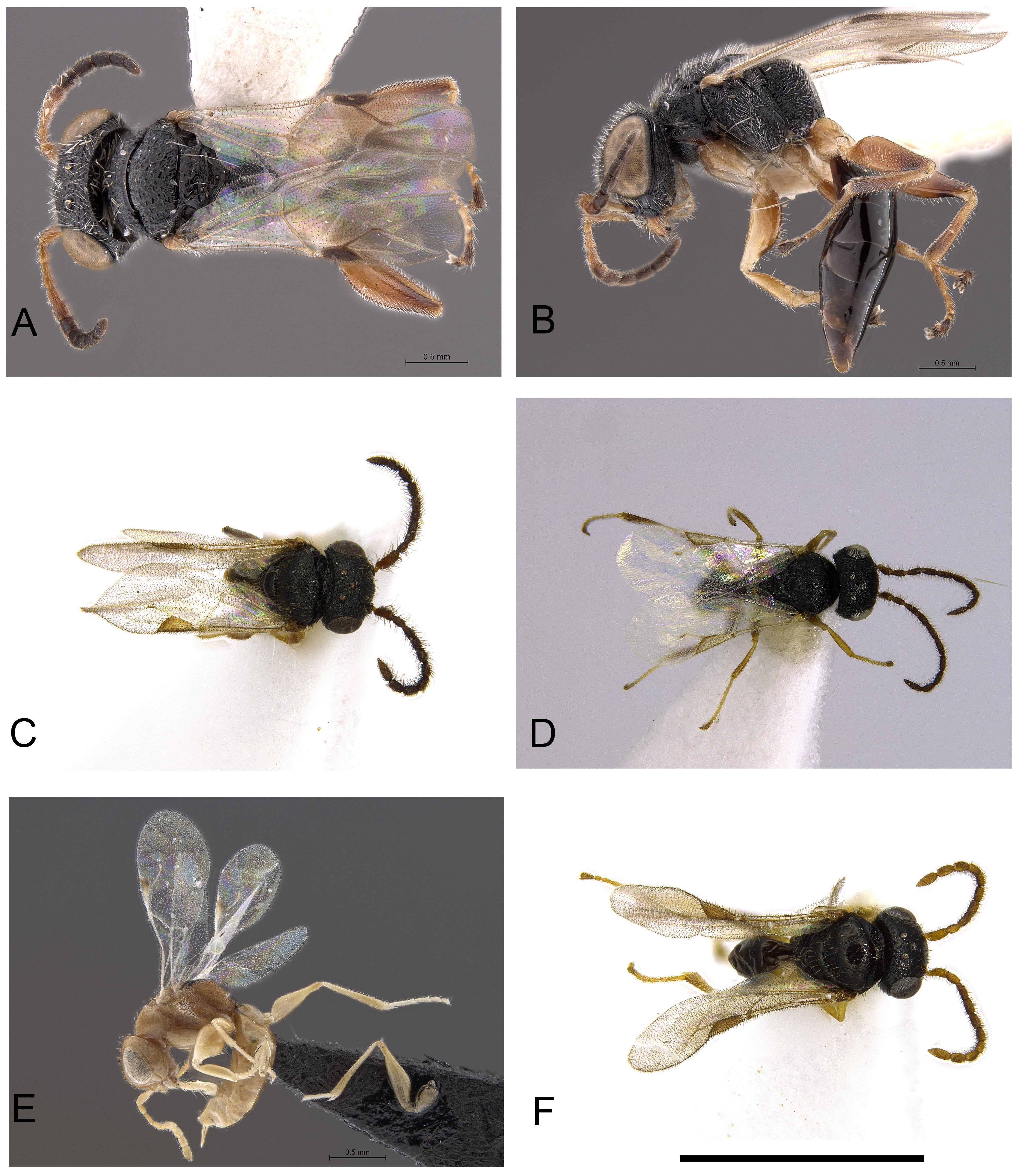
( Figs 74F View FIGURE 74 , 79C, F, G View FIGURE 79 )
Anteon zairense Benoit 1951d: 21 ; Olmi 1984: 406; 2005c: 236; Azevedo et al. 2010: 880; Olmi et al. 2015: 351; 2016: 70. Anteon terminale Olmi 2007b: 210 (syn. nov.); Azevedo et al. 2010: 880.
Description. ♀ (tentatively associated with the ♂ below; see remarks). Fully winged; body length 2.6–2.7 mm. Head black, except mandible testaceous; antenna testaceous, except antennomeres 6–10 brown (occasionally antennomere 5 partly brown); mesosoma and metasoma black; legs testaceous, except metacoxa partly brown. Antenna clavate; antennomeres in following proportions: 9:5:6:5:5:5:5:5:5:8.5. Head convex, dull, granulate and reticulate rugose (in specimen from Madagascar, 21°15.05’S 47°24.43’E, head slightly rugose, not granulate, with a large unsculptured area in front of anterior ocellus); frons with two lateral longitudinal keels near orbits and directed towards antennal toruli; frontal line complete; POL = 6; OL = 4; OOL = 4; OPL = 3; TL = 3; greatest breadth of lateral ocelli shorter than OL (3:4); occipital carina complete. Occasionally POL about as long as OL. Pronotum dull, granulate and rugose, with posterior margin shiny, unsculptured; posterior surface shorter than mesoscutum (5:14); pronotal tubercle reaching tegula. Mesoscutum, mesoscutellum and metanotum shiny, finely punctate, unsculptured among punctures. Notauli incomplete, reaching approximately 0.5 × length of mesoscutum. Metapectal-propodeal disc reticulate rugose, with strong transverse posterior keel; propodeal declivity with two complete longitudinal keels, with median area dull, as rugose as lateral areas. Forewing hyaline, without dark transverse bands; distal part of 2r-rs&Rs vein much shorter than proximal part (4.5:9). Protarsomeres in following proportions: 9:2:1.5:2.5:9.5. Enlarged claw ( Fig. 79C View FIGURE 79 ) with proximal prominence bearing one long bristle. Protarsomere 5 ( Fig. 79C View FIGURE 79 ) with about 8–9 bristles, without proximal and medial lamellae; apex with 7–9 lamellae. Tibial spurs 1/1/2.
♂ ( Fig. 74F View FIGURE 74 ). Fully winged; body length 1.7–3.4 mm. Head black; mandible yellow, with teeth brown; antenna completely brown, or totally testaceous, or brown, except antennomeres 1–3 testaceous; mesosoma black; metasoma black; legs completely brown, or testaceous, except metacoxa, club of metafemur and metatibia brown. Antenna filiform; antennomeres of specimen from Madagascar, 21°15.99’S 47°25.21’E, in following proportions: 10:6:7:6: 6:6:6:6.5:6.5:9. Antennomeres of A. terminale holotype in following proportions: 8.5:4:5:5:5:5:5:5:4.5:8. Head dull or shiny, reticulate rugose and granulate; clypeus completely smooth, without parallel keels; frontal line complete; frons without lateral keels directed towards antennal toruli (in specimen from Gabon, Mts. Doudou Reserve, frons with two tracks of lateral keels along orbits and directed towards antennal toruli; in specimen from Guinea, 7°42’N 8°23’W, frons with two strong lateral longitudinal keels along orbits and directed towards antennal toruli, and vertex with two oblique keels from lateral ocelli to occipital carina; in specimen from South Africa, 32°21.260’S 26°23.001’E, frons unsculptured and with very slightly rugose, without lateral keels directed towards antennal toruli); occipital carina complete; POL = 8; OL = 4; OOL = 6; OPL = 4; TL = 4. In holotype of A. terminale , POL = 4.5; OL = 3; OOL = 4.5; OPL = 2; TL = 2.5. Rarely head almost completely punctate, unsculptured among punctures (as in Anteon fisheri Olmi, 2003 ). Mesoscutum shiny, punctate and unsculptured among punctures, strongly rugose near anterior margin or in anterior third of mesoscutum; in specimen from Gabon, Doudou Mts. Reserve, mesoscutum completely punctate, unsculptured among punctures; in specimen from South Africa, 29°39‘23‘‘S 30°27‘41‘‘E, mesoscutum weakly granulate, except anterior region rugose and central area unsculptured. Notauli incomplete, reaching approximately 0.25–0.50 × length of mesoscutum. Mesoscutellum and metanotum shiny, punctate, unsculptured among punctures. Metapectal-propodeal disc with strong transverse posterior keel, reticulate rugose, dull; propodeal declivity dull, with two longitudinal keels and with median area as rugose as lateral areas; occasionally median area rugose and with numerous longitudinal keels; occasionally (specimens previously attributed to A. terminale ) median area partly shiny, unsculptured. In specimen from Zimbabwe, Chishawasha, propodeal declivity with two hardly visible longitudinal keels; in specimens from South Africa longitudinal keels absent. Forewing hyaline, without dark transverse bands; distal part of 2r-rs&Rs vein much shorter than proximal part (5:10; 2.5: 7 in A. terminale holotype). Paramere without distal inner pointed or rounded process, with long and slender dorsal proximal membranous process ( Figs 79F, G View FIGURE 79 ( Fig. 255 View FIGURE 255 in Olmi 1984 erroneous)). In specimen from South Africa, 33°34.092’S 18°47.680’E, inner side of paramere with some papillae. Tibial spurs 1/1/2.
Material examined. Types: ♂ holotype of A. zairense : DEMOCRATIC REPUBLIC OF THE CONGO: Basoko , V.1949, P.L.G. Benoit leg. ( MRAC) ; ♂ holotype of A. terminale : MADAGASCAR: Fianarantsoa, Ranomafana National Park, Vohiparara , 21°13.57’S 47°22.19’E, at broken bridge, 1110 m, 21–28.I.2002, MT, high altitude rainforest, R. Harin’Hala leg. GoogleMaps , MA-02-09A-13 ( CAS). Paratypes of A. terminale : MADAGASCAR: same locality label as holotype, 12–19.III.2002, MA-02-09A-20 GoogleMaps , 1♂ ( CAS). SOUTH AFRICA: KwaZulu-Natal, Rams- gate, Butterfly Sanctuary , 30°53.3‘S 30°20.4‘E, MT near stream, 9.VIII–2.IX.2004, M. Mostovski leg. GoogleMaps , 1♂ ( NMSA); same locality label, 3.IX–2.X.2004 GoogleMaps , 1♂ ( NMSA); same locality label, 20.III–25.IV.2005 GoogleMaps , 1♂ ( NMSA). Other material: CENTRAL AFRICAN REPUBLIC: Sangha-Mbaéré Prefecture, Dzanga-Ndoki National Park , 38.6 km 173° S Lidjombo, 2°21.60’N 16°03.20’E, 350 m, 23.V.2001, sweep, lowland rainforest, S. van Noort leg. GoogleMaps , 6♂♂ ( SAMC). GABON: Ogoové-Maritime Prov., Mts. Doudou Reserve , 25.2 km 304°NW Doussala, 02°13.63’S 10°23.67’E, 660 m, 15.III.2000, Sweep, GA 00-S98, Coastal Lowland Rainforest, undergrowth, low canopy in forest, SAM-HYM- PO023741, S. van Noort leg. GoogleMaps 1♂ ( SAMC). GUINEA: Nzérékoré Region, Mount Nimba, Gouan River, 7°42’N 8°23’W, 514 m, 15–22.I.1991, FIT, rainforest, L. LeBlanc leg. GoogleMaps , 1♂ ( PMA). KENYA: Coast Prov., Muhaka Forest , 4.32664°S 39.52462°E, 41 m, 11–25.X.2015, MT, indigenous forest, R. Copeland leg. GoogleMaps , 1♂ ( NMK); Coast Prov., Taita Hills, Vuria Forest , 3.41428°S 38.29178°E, 2162 m, MT just inside indigenous forest, 21.VIII–4.IX.2011, R. Copeland leg. GoogleMaps , 1♂ ( RSC); Coast Prov., Taita Hills, Chawia Forest , 3.47908°S 38.34162°E, 1614 m, 24.VII– 7.VIII.2011, MT, next to small forest pond, R. Copeland leg. GoogleMaps , 1♂ ( NMK); Coast Prov., Taita Hills, Ngangao Forest , 3.36930°S 38.34495°E, 1736 m, 26.VI–10.VII.2011, MT, indigenous forest, R. Copeland leg. GoogleMaps , 1♂ ( NMK); same locality label, 3.36100°S 38.34186°E, 1848 m, 13–27.V.2012 GoogleMaps , 2♂♂ ( NMK); Coast Prov., Taita Hills, Ngangao For- est, 3.36100°S 38.34186°E, 1848 m, 10.IX–2.X.2011, MT, indigenous forest, R. Copeland leg. GoogleMaps , 1♂ ( NMK); Coast Prov., Mrima Hill Forest , 4.48576°S 39.25845°E, 212 m, 17–31.X.2011, MT, indigenous forest edge, R. Copeland leg. GoogleMaps , 1♀ ( NMK); Coast Prov., Diani Beach area , 4.27559°S 39.59337°E, 10 m, 2–16.XII.2014, MT, shrubland off Diani Beach Rd., R. Copeland leg. GoogleMaps , 1♂ ( NMK); Coast Prov., Gede Forest , 3.30946°S 40.01941°E, 19 m, 22.VIII– 5.IX.2011, indigenous forest, MT, secondary forest, R. Copeland leg. GoogleMaps , 1♂ ( NMK); Coast Prov., Marenje Forest , 4.52814°S 39.24028°E, 76 m, 22.VIII–5.IX.2014, MT, indigenous forest, R. Copeland leg. GoogleMaps , 1♂ ( MOLC); Eastern Prov. , Kasaala area, 2.07846°S 38.22530°E, 740 m, 28.XI–4.XII.2013, MT, just inside isolated woodland patch, J. Bukhebi & R. Copeland leg. GoogleMaps , 1♂ ( NMK); Eastern Prov., Ngaia Forest , 0.32442°N 38.05038°E, 1057 m, bottom of forest, 26.X–10.XII.2011, MT, inside indigenous forest, R. Copeland leg. GoogleMaps , 1♂ ( NMK); Nairobi Prov., ICIPE Cam- pus, Kasarani , 1.22317°S 36.89653°E, 1600 m, 29.IV–V.2014, MT, near stream, meadow in degraded shrub-/grassland, R. Copeland leg. GoogleMaps , 1♂ ( NMK); same locality label, 3–10.VI.2014 GoogleMaps , 1♂ ( NMK); Nairobi Prov., ICIPE Campus, Kasarani , 1.22338°S 36.89655°E, 1604 m, 24.II–3.III.2014, MT, near stream, meadow in degraded shrub-/grassland, R. Copeland leg. GoogleMaps , 1♂ ( NMK); Western Prov., Kakamega District, Kakamega Forest, Kisere Forest Reserve , 00°23.73’N 34°53.165’E, 5400 feet, XI.2001, Manfred Kraemer & Co. Leg GoogleMaps ., 1♂ ( MTC). MADAGASCAR: An- tsiranana, Montagne d’Ambre National Park , 12°30.52’S 49°10.53’E, 960 m, 29.I.2001, netted by hand, M.E. Irwin leg. GoogleMaps , MA-01-01A-05, 1♂ ( CAS); same locality label, 19.III–6.IV.2001, MT, MA-01-01A-09, R. Harin’Hala leg. GoogleMaps , 1♂ ( CAS); same locality label, 26–29.I.2001, M.E. Irwin, E.I. Schlinger & R. Harin’Hala leg. GoogleMaps , MA-01-01A-02, 1♂ ( CAS); Antsiranana, Montagne d’Ambre National Park , 12°31.13’S 49°10.45’E, 1125 m, 6–21.IV.2001, MT, MA- 01-01D-07, R. Harin’Hala leg. GoogleMaps , 1♂ ( CAS); Antsiranana, SAVA Region, Vohemar District, Andranotsimaty dry for- est, 9 km NE Daraina, 13°10.17’S 49°42.04’E, 90 m, 14–21.II.2011, MT, dry dense forest, M. Irwin, R. Harin’Hala leg. GoogleMaps , MG-57-19, 2♂♂ ( CAS); Fianarantsoa, Ranomafana National Park, Vohiparara , at broken bridge, 21°13.57’S 47°22.19’E, 4–12.II.2002, 1110 m, MT, high altitude rainforest, R. Harin’Hala leg. GoogleMaps , MA-02-09A-15, 3♂♂ ( CAS); same locality label, 22–28.XI.2001, MA-02-09A-04 GoogleMaps , 12♂♂ ( CAS); same locality label, 6–15.V.2002 GoogleMaps , 2♂♂ ( CAS, MOLC); same locality label, 14–21.I.2002, MA-02-09A-12 GoogleMaps , 2♂♂ ( CAS); same locality label, 6–15.XII.2001, MA- 02-09A-06 GoogleMaps , 1♂ ( CAS); same locality label, 21–28.I.2002, MA-02-09A-13 ( CAS); Fianarantsoa, Ranomafana Na- tional Park, Belle Vue at Talatakely , 21°15.99’S 47°25.21’E, 1020 m, 15–22.XI.2001, MT, secondary tropical forest, R. Harin’Hala leg. GoogleMaps , MA-02-09C-03, 3♂♂, 1♀ ( CAS); same locality label, 5–13.V.2002, MA-02-09C-28 GoogleMaps , 1♀ ( MOLC); same locality label, 14–22.VII.2002, MA-02-09C-35 GoogleMaps , 1♀ ( MOLC) , 1♂ ( CAS); same locality label, 23.VI–4.VII.2002, MA-02-09C-33 , 1♂ ( CAS); same locality label, 28.IV–5.V.2002, MA-02-09C-27 , 1♂ ( CAS); same locality label, 12–19.II.2002, MA-02-09C-16 , 8♂♂ (6 in CAS, 2 in MOLC); same locality label 22–28.XI.2001, MA-02-09C-04 , 7♂♂ ( CAS); same locality label, 16.X–8.XI.2001, MA-02-09C-01 , 3♂♂ (2 in CAS, 1 in MOLC); Fianarantsoa, Ranomafana National Park, Vohiparara , 21°13.57’S 47°22.19’E, at broken bridge, 1110 m, 21– 28.I.2002, MT in high altitude rainforest, R. Harin’Hala leg. GoogleMaps , MA-02-09A-13, 1♀ ( CAS); same locality label, 14– 21.I.2002 GoogleMaps , 6♂♂ (2 in CAS, 4 in MOLC); Fianarantsoa, Ranomafana National Park , radio tower at forest edge, 21°15.05’S 47°24.43’E, 1130 m, 16.X–8.XI.2001, MT, mixed tropical forest, R. Harin’Hala leg. GoogleMaps , MA-02-09B-01, 1♀ ( MOLC) , 5♂♂ (4 in CAS, 1 in MOLC); same locality label, 15–25.VII.2002, MA-02-09B-35 , 2♂♂ ( CAS); same locality label, 12–19.II.2002, MA-02-09B-16 , 2♂♂ ( CAS); same locality label, 15–21.XII.2001, MA-02- 09B-07 , 1♂ ( MOLC); same locality label, 22–28.XI.2001, MA-02-09B-04 , 1♀ ( MOLC); same locality label, 14– 21.I.2002, MA-02-09B-12 , 2♀♀ ( CAS, MOLC) , 2♂♂ ( CAS); same locality label, 4–12.III.2002, MA-02-09B-19 , 1♂ ( MOLC); same locality label, 21–28.I.2002, MA-02-09B-13 , 1♂ ( MOLC); same locality label, 27.II–9.III.2003, MA-02-09B-54 , 1♂ ( CAS); same locality label, 18–29.VI.2003, MA-02-09B-64 , 1♂ ( MOLC); Fianarantsoa, Rano- mafana, JIRAMA water works, 21°14.91‘S 47°27.13‘E, 690 m, 21–24.XII.2001, MT, near river, R. Harin’Hala leg. GoogleMaps , MA-02-09D-08, 1♂ ( CAS); same locality label, 28.I–4.II.2002, MA-02-09A-14 GoogleMaps , 2♂♂ ( CAS, MOLC); same local- ity label, 10–14.I.2002, MA-02-09A-11 , 1♂ ( CAS); Mahajanga, Sofia District, 45 km S Antsohihy, 5 km W Anjia- mangirana, Analagnambe dry degraded forest, 15°09.42’S 47°47.05’E, 97 m, 26.V–2.VI.2011, MT, MG-61-15 GoogleMaps , 3♂♂ (2 in CAS, 1 in MOLC); Toamasina, Ankerana , 18°24.23’S 48°48.09’E, 1108 m, 16–21.I.2012, MT, rainfor- est, B.L. Fisher et al. leg., BLF27665 GoogleMaps , 2♂♂ ( CAS); Toamasina, Andasibe National Park , 18°55.58’S 48°24.47’E, botanic garden near entrance to park, 1025 m, 2–8.X.2001, MT, tropical forest, R. Harin’Hala leg. GoogleMaps , MA-01-08B-14, 1♂ ( CAS); same locality label, 1–7.XI.2001, MA-01-08B-18 GoogleMaps , 1♂ ( CAS); same locality label, 1–5.IX.2001, MA-01- 08B-11 GoogleMaps , 10♂♂ ( CAS); same locality label, 7–16.XI.2001 GoogleMaps , 1♂ ( CAS). SOUTH AFRICA: Eastern Cape, Port St. Johns , I.1924, R.E. Turner leg. , 1♂ ( NHMUK); same locality label, XII.1923, 1 ♂ ( NHMUK); Eastern Cape, Gra- hamstown , 1♂ ( AEIC); Eastern Cape, Gonubie, 32°56’S 28°02’E, 3–12.I.1995, MT, Coastal Dune Forest near River Mouth , SAM-HYM-P013717, S. van Noort leg. GoogleMaps , 1♂ ( SAMC); Eastern Cape, Asante Sana Game Reserve , 32°14.990’S 24°55.962’E, 2183 m, 29.X.2009 – 23.II.2010, MT, Karoo Escarpment Grassland, S. van Noort leg. GoogleMaps , 1♂ ( SAMC); Eastern Cape, Winterberg, The Hoek Farm , 32°21.260’S 26°23.001’E, 1879 m, 9.IV–26.VII.2010, YPT, Amathole Mistbelt Grassland, S. van Noort leg. GoogleMaps , 2♂♂ ( SAMC); same locality label, 3.IX–30.X.2009, WTB09- GRA1-Y01 GoogleMaps , 13♂♂ ( SAMC); same locality label, 6.X.2010 – 18.I.2011, MT, WTB09-GRA1-M05 GoogleMaps , 1♂ ( MOLC); KwaZulu-Natal, Ubombo, Lake Sibaya , 1♂ ( PMA); KwaZulu-Natal, 75 km WSW Estcourt, Cathedral Peak Forest Station , 1♂ ( CNC); KwaZulu-Natal, Cathedral Peak Natural Reserve, Rainbow Gorge , 28°57.60’S 29°13.61’E, 1480 m, 14.XII.2005 – 29.I.2006, MT, M. Mostovski leg. GoogleMaps , 3♂♂ ( NMSA); KwaZulu-Natal, Ramsgate, Butterfly Sanctuary , 30°53.3‘S 30°20.4‘E, MT near stream, 6.VI–9.VII.2004, 9.VII–9.VIII.2004, 9.VIII–2.IX.2004, 3.IX– 2.X.2004, 3–30.X.2004, 1.XI–2.XII.2004, 9.I–2.II.2005, 27.II–19.III.2005, 20.III–25.IV.2005, 27.IV–27.VII.2005, 18.XI.2006 – 26.II.2007, M. Mostovski leg. GoogleMaps , 37♂♂ ( NMSA); same locality label, 27.IV–27.VII.2005, M. Mostovski leg. GoogleMaps , 1♂ ( NMSA); KwaZulu-Natal, Karkloof , 29°19.1’S 30°15.5’E, 1325 m, 28.IX–3.X.2005, YPT, M. Mostovski leg. GoogleMaps , 1♂ ( NMSA); same locality label, 25.VII–25.IX.2005, MT, M. Mostovski leg. GoogleMaps , 8♂♂ ( NMSA); KwaZulu-Natal, Vernon Crookes Nat. Reserve , 250 m, 30°17.4’S 30°36.9’E, 24.I–10.V.2006, MT, M. Mostovski leg. GoogleMaps , 1♂ ( NMSA); KwaZulu-Natal, Royal Natal National Reserve, Gudu Forest , 28°40.90’S 28°55.78’E, 1680–1730 m, 13.XII.2005 – 28.I.2006, MT, M. Mostovski leg. GoogleMaps , 1♂ ( NMSA); KwaZulu-Natal, Ashburton , 29°39’23’’S 30°27’41’’E, 29.X– 9.XI.2005, MT, G. Whiteley leg. GoogleMaps , 1♂ ( DJBC); Mpumalanga, Krüger National Park , Skukuza Malt ., 1♂ ( PMA); Western Cape, Stellenbosch, Jonkershoek , 3♂♂ ( PMA, AEIC, AMNH); Western Cape, Ceres , IV.1925, R.E. Turner leg. , 1♂ ( NHMUK); Western Cape, Cape Peninsula, Hout Bay , Skoorsteenkop , 1♂ ( ZIL); Western Cape, Cape Town, above Tokai Forest, Constantiaberge , above Donkerboskloof , 34°02’N 18°23.5’E, 460 m, 10–17.III.1995, Mesic Mountain Fynbos, Protea coronata dominated, MT, SAM-HYM-PO13732, S. van Noort leg. GoogleMaps , 1♂ ( SAMC); same locality label, 12–17.IX.1993, Mesic Mountain Fynbos on Sandstone , SAM-HYM-PO03786 GoogleMaps , 1♂ ( SAMC); Western Cape, Constantiaberg, above Donkerboskloof, 34°2.175‘N 18°23.528‘E, 460 m, 5–13.X.1993, MT, Mesic Mountain Fynbos with kloof forest elements, S. van Noort leg. GoogleMaps , 1♂ ( SAMC); same locality label, 19.IX–10.X.1995 GoogleMaps , 1♂ ( SAMC); Western Cape, Constantiaberge, 34°02.5‘S 18°23.5‘E, 640 m, above road to mast overlooking Hout Bay , 25.I–2.II.1994, MT, mesic mountain fynbos, S. van Noort leg. GoogleMaps , 1♂ ( SAMC); Western Cape, Wolfgat Nature Reserve , 34°04‘S 18°39‘E, 5.IX.1995, sweep, S Coast Strandveld, SAM-HYM-PO11635, S. van Noort leg. GoogleMaps , 1♂ ( SAMC); Western Cape, Walker Bay Nature Reserve , 34°27.41‘S 19°21.39‘E, 11.VIII–6.IX.1997, S. van Noort leg. GoogleMaps , 1♂ ( SAMC); same locality label, 17–31.V.1997, MT, S. van Noort leg. GoogleMaps , 2♂♂ ( SAMC); Western Cape, Walker Bay Nature Reserve, 34°27.414‘S 19°21.393‘E, 21.II–21.III.1998, MT, South Coast Strandveld , 57 m, S. van Noort leg. GoogleMaps , 2♂♂ ( SAMC); Western Cape, Anyskop Farm , 5.5 km 290° W Langebaanweg, 32°57.394‘S 18°05.324‘E, 11–18.IX.2002, MT, Sand Plain Fynbos, S. van Noort leg. GoogleMaps , 2♂♂ ( SAMC); same locality label, 18–25.IX.2002 GoogleMaps , 1♂ ( SAMC); Western Cape, Langberg Farm , 3 km 270° W Langebaanweg, 32°58.461‘S 18°07.344‘E, 6–13.XI.2002, MT, Sand Plain Fynbos, S. van Noort leg. GoogleMaps , 3♂♂ ( SAMC); Western Cape, Langberg Farm , 3 km 280° W Langebaan- weg, 32°58.045‘S 18°07.418‘E, 18–25.IX.2002, MT, Sand Plain Fynbos, S. van Noort leg. GoogleMaps , 4♂♂ ( SAMC); same locality label, 4–11.IX.2002 GoogleMaps , 4♂♂ ( SAMC); same locality label, 11–18.IX.2002 GoogleMaps , 20♂♂ ( SAMC); Western Cape, West Coast Fossil Park , 3 km 280° W Langebaanweg, 32°58.020‘S 18°07.285‘E, 18–25.IX.2002, MT, rehabilitated mine dump, S. van Noort leg. GoogleMaps , 1♂ ( SAMC); Western Cape, West Coast Fossil Park , 3 km 270° W Langebaanweg, 32°58.445‘S 18°07.236‘E, 11–18.IX.2002, MT, sand plain fynbos, S. van Noort leg. GoogleMaps , 2♂♂ ( SAMC); Western Cape, Gamkaberg Nature Reserve , 33°43.663‘S 21°57.600‘E, 940 m, 23.V–31.VII.2009, MT, Rooiberg Sandstone Fynbos, S. van Noort leg. GoogleMaps , 1♂ ( SAMC); Western Cape, Kogelberg Nature Reserve, 34°16.481‘S 19°01.033‘E, 16.III– 16.IV.1999, MT, Mesic Mountain Fynbos, last burnt c. 1978, S. van Noort leg. GoogleMaps , 3♂♂ ( SAMC); same locality label, 16.X–16.XI.1999 GoogleMaps , 6♂♂ ( SAMC); same locality label, 16.XII.1999 – 16.I.2000 GoogleMaps , 2♂♂ ( SAMC); same locality label, 16.XI–16.XII.1999 GoogleMaps , 2♂♂ ( SAMC); same locality label, 16.I–16.II.2000 GoogleMaps , 4♂♂ ( SAMC); same locality label, 16.II– 16.III.1999 GoogleMaps , 9♂♂, 2♀♀ ( SAMC); same locality label, 16.XII.1998 – 16.I.1999 GoogleMaps , 3♂♂ ( SAMC); same locality label, 16.XI–16.XII.1998 GoogleMaps , 3♂♂, 1♀ ( SAMC); Western Cape, Koeberg Nature Reserve , 33°37.622‘S 18°24.259‘E, 31.X– 28.XI.1997, MT, West Coast Strandveld, S. van Noort leg. GoogleMaps , 1♂ ( SAMC); Western Cape, Fynbos Estate , Dragon- ridge, 33°34.092‘S 18°47.680‘E, 635 m, 28.IX–28.XII.2010, MT, Boland Granite Fynbos, S. van Noort leg. GoogleMaps , DRA09-FYN1-M05, 1♂ ( SAMC); Western Cape, Banghoek Valley, Dwarsriviershoek Farm , 33°56.232‘S 18°57.711‘E, 410 m, 20.X–27.XI.2013, MT, Mesic Mountain Fynbos, BH 12-FYN3-M14, S. van Noort leg. GoogleMaps , 1♂ ( MOLC). UGANDA: Western Region, Kibale National Park , Kanyawara Makerere University Biological Field Station, 0°33.784’S 30°21.617’E, 1500 m, 2–12.VIII.2008, MT, primary mid-altitude rainforest, S. van Noort leg. GoogleMaps , 1♂ ( SAMC). ZIMBABWE: Harare, Chishawasha , III.1978, A. Watsham leg. , 1♂ ( NHMUK) .
Hosts. Unknown.
Distribution. Central African Republic, Democratic Republic of the Congo, Gabon, Guinea, Kenya, Madagascar, South Africa, Uganda, Zimbabwe.
Remarks. The above description of the ♀ is based on a few specimens collected in Madagascar (21°15.99’S 47°25.21’E, 21°13.57’S 47°22.19’E, 21°15.05’S 47°24.43’E), Kenya (4.48576°S 39.25845°E) and South Africa (34°16.481’S 19°01.033’E); the specimens were not reared and were tentatively assigned to Anteon zairense Benoit (based on ♂ description). Within the same locality in Madagascar, Anteon cautum Olmi (only known from ♂♂) was also collected, consequently it is possible that the above ♀♀ represent the opposite sex of A. cautum . Anteon terminale is here synonymized with A. zairense , based on the fact that within the same localities in Madagascar, mixed populations comprising ♂♂ with either a rugose or unsculptured median area of the metapectal-propodeal disc, and either a rugose or unsculptured propodeal declivity, were collected. As the unique difference between the two species is the sculpture of the metapectal-propodeal disc median area, they were synonymized.


| MRAC |
Musée Royal de l’Afrique Centrale |
| CAS |
California Academy of Sciences |
| NMSA |
KwaZulu-Natal Museum |
| SAMC |
Iziko Museums of Cape Town |
| PMA |
Provincial Museum of Alberta |
| NMK |
National Museums of Kenya |
| NHMUK |
Natural History Museum, London |
| AEIC |
American Entomological Institute |
| CNC |
Canadian National Collection of Insects, Arachnids, and Nematodes |
| AMNH |
American Museum of Natural History |
| ZIL |
Academy of Sciences, Zoological Institute |
No known copyright restrictions apply. See Agosti, D., Egloff, W., 2009. Taxonomic information exchange and copyright: the Plazi approach. BMC Research Notes 2009, 2:53 for further explanation.
|
Kingdom |
|
|
Phylum |
|
|
Class |
|
|
Order |
|
|
Family |
|
|
Genus |
Anteon zairense Benoit, 1951
| Olmi, Massimo, Copeland, Robert S. & Noort, Simon Van 2019 |
Anteon zairense
| Azevedo, C. O. & Madl, M. & Olmi, M. 2010: 880 |
| Azevedo, C. O. & Madl, M. & Olmi, M. 2010: 880 |
| Olmi, M. 2007: 210 |
| Olmi, M. 2005: 236 |
| Olmi, M. 1984: 406 |
| Benoit, P. L. G. 1951: 21 |