
Lepanus australis Matthews, 1974
|
publication ID |
https://doi.org/ 10.11646/zootaxa.4695.3.1 |
|
publication LSID |
lsid:zoobank.org:pub:32E17629-F29A-47C8-ACCB-69A32C17B147 |
|
persistent identifier |
https://treatment.plazi.org/id/03ED0167-FF86-FFB4-FF1D-F470FD59FA99 |
|
treatment provided by |
Plazi |
|
scientific name |
Lepanus australis Matthews, 1974 |
| status |
|
Lepanus australis Matthews, 1974 View in CoL
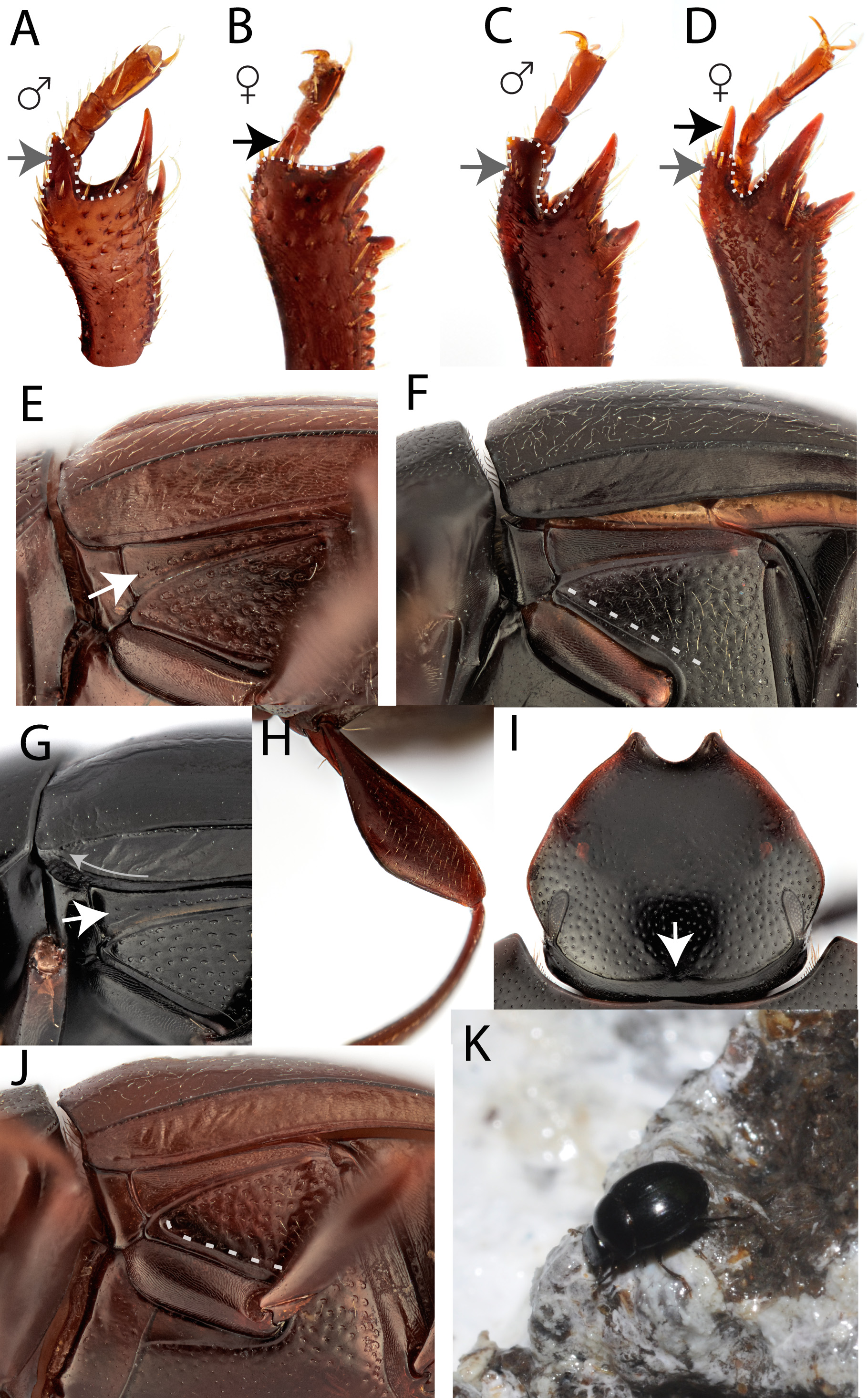
( Figs. 1 View FIGURE 1 C–D, F, K; 2A; 3A; 4A)
Lepanus australis Matthews, 1974: 109 View in CoL .
Type material examined. Holotype: ♂ “ 5 mi. N. Batemans Bay N.S.W. 16-VIII-67 E. Matthews ” / “ Lepanus australis Det 1972 M., E.G. Matthews HOLOTYPE ” / “ ANIC Database No. 25 057863” / “ HOLOTYPE ”, in ANIC [35°40’0”S, 150°15”0”E]. Paratypes: Macquarie Pass , [34°34’0”S, 150°38’0”E], 29.xii.1967, E. Matthews (25-057864 1 specimen ♂, 4 specimens sex undetermined in ANIC) GoogleMaps ; Clyde Mountain (general), [35°33’0”S, 149°57’0”E], 9.i.1968 – 12.i.1968, E. Matthews (25-057865 1 specimen sex undetermined in ANIC) GoogleMaps ; 3–7 miles N of Eden , [37°0’0”S, 149°55’0”E], 13.i.1968, E. Matthews (25-057866 2 specimen ♂, 2 specimen sex undetermined in ANIC) GoogleMaps ; 5–17 miles S of Eden , [37°14’0”S, 149°55’0”E], 13.i.1968, E. Matthews (25-057867 1 specimen sex undetermined in ANIC) GoogleMaps ; Mallacoota National Park , [37°30’0”S, 149°46’0”E], 13.i.1968, E. Matthews (25-057868 1 specimen sex undetermined in ANIC) GoogleMaps .
Other material examined. Almost 600 other specimens were examined from around 150 localities.
Queensland: St Lawrence , 18.5 km W, 22°21’4”S, 149°20’33”E, 29.vi–22.x.2000, (T107480–T 107482 in QM) GoogleMaps ; Fairlie’s Knob , 0.5 km S, 25°30’32”S, 152°17’22”E, 20.x–20.xii.2000, (T 107490 in QM) GoogleMaps ; Fairlie’s Knob , 0.5 km S, 20.xii.2000 – 23.iii.2001, (T107491, T107493–T 107495 in QM) ; Fairlie’s Knob , 0.5 km S, 22–23.iii.2001, (T 107500 in QM) ; Lake Bowaddy [Lake Bowarrady], Fraser Island , [25°9’0”S, 153°13’0”E], 3.xii.1975, G. Thompson & J.A. Slater (25-058488 1 specimen in QM) GoogleMaps ; Yidney Scrub, Fraser Island , [25°19’0”S, 153°11’0”E], 1.xii– 4.xii.1975, G. Thompson & J.A. Slater (25-058491 2 specimens in QM) GoogleMaps ; Booloumba Creek State Forest River Trail, 26°38’50”S, 152°38’45”E, 350m, 15.i.2000, R.A. Anderson (CMNEN-00030001 in CMNC) GoogleMaps ; Tinana Creek , 25°45’7”S, 152°41’38”E, 35 m, 22.xi–7.xii.2011, G.B. Monteith (25-0053884 1 specimen also as COL 2345 in ANIC) GoogleMaps ; Tallegalla Weir Junction , 25°45’25”S, 152°41’49”E, 35m, 6–7.xii.2011, G.B. Monteith (25-053887 1 specimen in ANIC) GoogleMaps ; Nangur State Forest , 2nd site, 26°7’55”S, 151°58’43”E, 24.xi.1995 – 3.ii.1996, (T 107570 in QM) GoogleMaps ; Jack Smith [Scrub Conservation] Park on Boat Mountain , 26°9’17”S, 151°54’34”E, 26.i–20.iv.1995, (T107462 – T107464, T107533–T 107552 in QM) GoogleMaps ; Jack Smith [Scrub Conservation] Park on Boat Mountain , 26°9’17”S, 151°54’34”E, 15.xii.1994 – 26.i.1995, (T 107553 in QM) GoogleMaps ; Kin Kin Creek , lower, 26°14’15”S, 152°58’52”E, 18– 19.ii.2006, (T 135125 in QM) GoogleMaps ; Elanda Point, National Park Office , 26°15’28”S, 152°59’44”E, 17.ii.2006, (T135122– T 135124 in QM) GoogleMaps ; Cooran Plateau via Gympie , [26°21’0”S, 152°47’0”E], 1300 m, 10–11.iii.1973, R.I. Storey (25- 058486 x 12 in QM, 25-058581, 2 specimens in QDPC) GoogleMaps ; Cooran Plateau, 1300 feet via Gympie , [26°21’0”S, 152°47’0”E], 396 m, 3.x–3.xi.1973, R.I. Storey (CMNEN-00030019 in CMNC) GoogleMaps ; Kingaroy , 6 km SE, 26°34’48”S, 151°52’35”E, 23–26.xii.2005,(T132946–T 132949in QM) GoogleMaps ; Mapleton Falls National Park , 26°37’49”S, 152°50’21”E, 30.xi.1991 - 8.i.1992, (T 107573 in QM) GoogleMaps ; 4 km W Buderim , [26°41’0”S, 153°0’0”E], 6.ix.1978, I.F.B. Common (25- 059200 x 1 in ANIC) GoogleMaps ; Chevallum, via Nambour , 26°42’3”S, 153°0’33”E, 12.v–27.ix.1978, (T 107594 in QM) GoogleMaps ; Conondale Range, Site 1, 26°42’46”S, 152°37’8”E, 20.iv-2.v.1995, (T107567–T 107568 in QM) GoogleMaps ; Mary Cairncross Park , 26°46’52”S, 152°52’56”E, 29.xi.1991 - 8.i.1992, (T 107574 in QM) GoogleMaps ; Landsborough , 2.55 km NE, 26°47’22”S, 152°58’41”E, 28.viii.2010, G.B. Monteith (25- 060783 1 specimen also as COL 773 in ANIC) GoogleMaps ; Saddletree Creek , 26°51’50”S, 151°38’2”E, 29–30.xii.2010, G.B. Monteith & K. Will (25- 060832 x2 also as COL1464-COL 1465 in ANIC) GoogleMaps ; Saddletree Creek , 26°51’50”S, 151°38’2”E, 22–29.xii.2010, Sota & Takami, (25- 060834 x10 also as COL1467- COL 1468 in ANIC) GoogleMaps ; Saddletree Creek , 26°51’50”S, 151°38’2”E, 22–30.xii.2010, G.B. Monteith & K. Will (25- 060835 7 specimens also as COL 1469–1470 in ANIC) GoogleMaps ; 5 km E Yarraman , [26°52’0”S, 152°3’0”E], 19.vi.1982, L. Hill, (25-059203 1 specimen in ANIC) GoogleMaps ; Top of Blackbutt Range , 26°52’38”S, 152°11’32”E, 24.xi.1995 - 3.ii.1996, (T107517–T 107532 in QM) GoogleMaps ; Bunya Mountains, Dandabah , 26°52’47”S, 151°35’44”E, 20.ix.2007, (T 151105 in QM) GoogleMaps ; 3 km N Upper Yarraman State Forest , 26°52’47”S, 151°53’4”E, 30.iii.1983, (T107571–T 107572 in QM) GoogleMaps ; Bunya Mountain National Park, Westcott Campground , 26°51’51”S, 151°34’17”E, 1100 m, 18.i.2000, R.A. Anderson (CMNEN-00030002, CMNEN-00030004 in CMNC) GoogleMaps ; Bunya Mountain National Park, Dandabah Picnic Area , 26°52’54”S, 151°35’23”E, 1100 m, 19.i.2000, R.A. Anderson (CMNEN-00030003 in CMNC) GoogleMaps ; Blackbutt Range, 1 km E Benarkin, [26°53’0”S, 152°10’0”E], 19.vi.1982, L. Hill, (25-059202 1 specimen in ANIC) GoogleMaps ; Upper Yarraman State Forest via Maidenwell , [26°54’0”S, 151°54’0”E], 11.i.1975, G.B. Monteith (25- 058493 3 specimens in QM) GoogleMaps ; Wild Horse Mountain , 1.2 km SW, 26°55’26”S, 152°59’24”E, 15–16.xi.2007, (T 151108 in QM) GoogleMaps ; Wild Horse Mountain , 1.2 km SW, 26°55’26”S, 152°59’24”E, 23.i–13.ii.2008, (T154607– T 154614 in QM) GoogleMaps ; Bribie Island , 1.3 km NE of national park headquarters, 27°0’54”S, 153°7’30”E, 10 m, 8–9.x.2010, G.B. Monteith (25- 060876 x1 also as COL 1141in ANIC) GoogleMaps ; Bribie Island , 0.85 km NE of national park headquarters, 27°1’5”S, 153°7’23”E, 8–9.x.2010, G.B. Monteith (25- 060877 1 specimen also as COL 1142 in ANIC) GoogleMaps ; Brisbane, Forest Park, Scrub Creek Road, [27°1’0”S, 152°26’0”E], 18.ix–29.x.1998, P. Bouchard (25-058494 1 specimen in QM) GoogleMaps ; Brisbane Forest Park, 27°25’41”S, 152°50’18”E, 1–15.x.2002, J. Skevington & J. Cumming (CMNEN- 00030008 in CMNC) GoogleMaps ; Blackbutt Range ( Bottom ), 8 miles E Blackbutt, [27°3’0”S, 151°55’0”E], 22–23.xii.1973, R.I. Storey (25-058580 2 specimens in QDPC) GoogleMaps ; Mount Deongwar, 3 km S, Site 3, 27°13’41”S, 152°15’36”E, 30.xii.1998 – 26.iii.1999, (T107285–T 107292 in QM) GoogleMaps ; Mount Deongwar, 3 km S, Site 3, 27°13’41”S, 152°15’36”E, 14.x–30.xii.1998, (T 107391 in QM) GoogleMaps ; Mount Deongwar, 3 km S, Site 2, 27°13’49”S, 152°15’25”E, 30.xii.1998 – 26.iii.1999, (T107282–T 107284 in QM) GoogleMaps ; Mount Deongwar, 3 km S, Site 2, 27°13’49”S, 152°15’25”E, 14.x– 31.xii.1998, (T 107390 in QM) GoogleMaps ; Mount Glorious , barracks, 27°19’54”S, 152°45’12”E, 16–28.iv.2007, (T 148366 in QM) GoogleMaps ; Mount Glorious , barracks, 27°19’54”S, 152°45’12”E, 12–15.iii.2008, (T 156700 in QM) GoogleMaps ; Crows Nest National Park, Perseverance Section, Site 1, 27°19’8”S, 152°6’’27”E, 4–5.xii.2003, (T 120685 –T 120687 in QM) ; Mount Glorious , [27°20’0”S, 152°46’0”E], 630 m, 14.xi.1986 – 30.i.1987, T. Hiller, (25-059197 3 specimens, 25- 059198, 2 specimens in ANIC) GoogleMaps ; Mount Glorious , [27°20’0”S, 152°46’0”E], 635 m, ii.1989, H.F. & A.T. Howden (CMNEN-00030007 in CMNC) GoogleMaps ; Stony Creek, via Samford , 27°20’20”S, 152°47’52”E, 22.x.1994 - 2.ii.1995, (T107554–T 107558 in QM) GoogleMaps ; Stony Creek, via Samford , 27°20’20”S, 152°47’52”E, 2.ii–iv.1995, (T107559– T 107566 in QM) GoogleMaps ; Mount Glorious , 2 km S, 27°21’9”S, 152°46’7”E, 28–29.i.2006, (T133758–T 133761 in QM) GoogleMaps ; Boombana National Park, Site 1, 27°24’8”S, 152°47’22”E, 1.x.2003 – 30.x.2003, (T 122130 in QM) GoogleMaps ; Boombana National Park, Site 1, 27°24’8”S, 152°47’22”E, 15–16.ii.2004, (T 122132 in QM) GoogleMaps ; Boombana National Park, Site 1, 27°24’8”S, 152°47’22”E, 2.i.2004 – 30.i.2004, (T 122794 –T 122795 in QM) GoogleMaps ; Boombana National Park , 27°25’55”S, 152°53’49”E, 230 m, 18.ii.2012 – 19.ii.2012, G.B. Monteith (25-053911 x 1 in ANIC) GoogleMaps ; McAfee’s Lookout , 0.5 km SW, 27°25’58”S, 152°52’14”E, 18.x.1999 - 6.ii.2000, (T 107475 in QM) GoogleMaps ; McAfee’s Lookout , 1 km SW, 27°26’15”S, 152°52’14”E, 18.x.1999 – 6.ii.2000, (T 107476 in QM) GoogleMaps ; Enoggera Reservoir, Site 8, 27°26’37”S, 152°54’14”E, 21.xii.1999 – 27.i.2000, (T107471–T 107473 in QM) GoogleMaps ; Enoggera Reservoir, Site 8, 27°26’37”S, 152°54’14”E, 27.i– 15.iii.2000, (T 107474 in QM) GoogleMaps ; Enoggera Reservoir, Site 8, 27°26’37”S, 152°54’14”E, 15.iii–18.v.2000, (T107478– T 107479 in QM) GoogleMaps ; Enoggera Reservoir, Site 5, 27°26’44”S, 152°55’19”E, 16.x–21.xii.1999, (T107467–T 107469 in QM) GoogleMaps ; Enoggera Reservoir , site 5, 27°26’44”S, 152°55’19”E, 21.xii.1999 – 27.i.2000, (T 107470 in QM) GoogleMaps ; Enoggera Reservoir , site 3, 27°26’44”S, 152°55’19”E, 15.iii–18.v.2000, (T 107477 in QM) GoogleMaps ; McAfee’s Lookout , 0.7 km SW, 27°26’8”S, 152°52’17”E, 6.vii–16.x.1999, (T107393–T 107394 in QM) GoogleMaps ; Gold Creek Reservoir, Site 4, 27°27’43”S, 152°52’21”E, 12–14.x.2007, (T 151106 in QM) GoogleMaps ; Gold Creek Reservoir , 27°27’46”S, 152°52’54”E, 12–14.x.2007, (T 151107 in QM) GoogleMaps ; Slaughter Falls , 27°28’44”S, 152°57’34”E, 6–7.ii.2001, (T 107483 in QM) GoogleMaps ; Boscombe Road, Brookfield , 27°28’57”S, 152°55’1”E, 12–13.ii.2011, G.B. Monteith (25-053877 1 specimen also as COL 1678 in ANIC) GoogleMaps ; Gold Creek Reservoir, Site 2, 27°28’5’’S, 152°52’20”E, 4.xi.2003, (T 122131 in QM) GoogleMaps ; Upper Brookfield Road, Brisbane , [27°29’0”S, 152°52’0”E], 24.viii–7.ix.1975, R.I. Storey (25-058489 1 specimen in QM) GoogleMaps ; Upper Brookfield Road, Brisbane , [27°29’0”S, 152°52’0”E], 22.ix–4.x.1975, R.I. Storey (25-058490 5 specimens in QM) GoogleMaps ; Kenmore Kookaburra Street , 27°29’28”S, 152°55’23”E, 16–17.xi.2010, <collector unknown>, (25- 060906 1 specimen also as COL 1197 in ANIC) GoogleMaps ; Kenmore Hills , 27°29’28”S, 152°55’24”E, 20–21.i.2011, G.B. Monteith (25- 065490 2 specimens in ANIC) GoogleMaps ; Kenmore , 27°30’24”S, 152°55’52”E, 20–21.i.2011, G.B. Monteith (25-065489 2 specimens in ANIC) GoogleMaps ; Mabb Street, Kenmore , 27°30’25”S, 152°55’52”E, 16–17.xi.2010, G.B. Monteith (25- 060889 1 specimen also as COL 1196 in ANIC) GoogleMaps ; The Knobby , 4 km W Glamorgan Vale, 27°30’27”S, 152°35’18”E, 13.i– 16.v.1999, (T 107279 in QM–T 107281 in QM) GoogleMaps ; Cameron’s Scrub , top ridge, 27°30’29”S, 152°43’54”E, 13.i– 16.v.1999, (T107303–T 107310 in QM) GoogleMaps ; Cameron’s Scrub , 27°30’32”S, 152°43’48”E, 75 m, 30.iv–1.v.2012, G.B. Monteith (25-057574 2 specimens, 25-075575 5 specimens in ANIC) GoogleMaps ; Long Pocket , river bank, 27°30’34”S, 152°59’53”E, 1.xi–4.xi.1999, (T 107395 in QM) GoogleMaps ; Cameron’s Scrub , gully, 27°30’35”S, 152°43’54”E, 13.i–16.v.1999, (T107311–T 107347 in QM) GoogleMaps ; Cameron’s Scrub , gully, 27°30’35”S, 152°43’54”E, 11.xi.1998 – 13.i.1999, (T107349– T 107369 in QM) GoogleMaps ; Cameron’s Scrub , below road, 27°30’45”S, 152°43’39”E, 13.i–16.v.1999, (T107293–T 107295 in QM) GoogleMaps ; Belmont Hill, top, 27°30’48”S, 153°6’’59”E, 12.xii.1997 – 7.v.1998, (T107417–T 107433 in QM) ; Cameron’s Scrub, Snig track, 27°30’49”S, 152°43’43”E, 13.i–16.v.1999, (T107296–T 107302 in QM) GoogleMaps ; Cameron’s Scrub, Snig track, 27°30’49”S, 152°43’43”E, 11.xi.1998 – 13.i.1999, (T 107389 in QM) GoogleMaps ; Whites Hill Reserve, Carnelian Street , 27°30’58”S, 153°4’41”E, 20–22.iv.2001, (T 107499 in QM) GoogleMaps ; Pullenvale State Forest , 27°30’59”S, 152°51’44”E, 9–11.iv.2001, (T107465–T 107466 in QM) GoogleMaps ; Bulimba Creek, Carindale , 27°30’9”S, 153°6’’34”E, 28.vii–1.ix.2003, (T 120590 –T 120591 in QM) ; Bulimba Creek, Carindale , 27°30’9”S, 153°6’’34”E, 27.v–30.vi.2003, (T 120592 in QM); Bulimba Creek, Carindale, 27°30’9”S, 153°6’’34”E, 1.xii.2003 - 2.i.2004, (T 122796 in QM) ; Sankey’s Scrub, Camp Hill , 27°31’1”S, 153°5’6”E, 20–22.iv.2001, (T 107497 in QM) GoogleMaps ; Rainbow Forest, Cubberla Creek , 27°31’6”S, 152°57’40”E, 24.xi–21.xii.2005, (T132653–T 132654 in QM) GoogleMaps ; Rainbow Forest, Cubberla Creek , 27°31’6”S, 152°57’40”E, 24–25.xi.2005, (T132655–T 132657 in QM) GoogleMaps ; Perry’s Knob , 4 km NNE Rosewood, 27°36’11”S, 152°36’17”E, 13.i.1999 – 16.v.1999, (T107252–T 107278 in QM) GoogleMaps ; Perry’s Knob , 4 km NNE Rosewood, 27°36’11”S, 152°36’17”E, 11.xi.1998 – 13.i.1999, (T107348, T107370–T 107388 in QM) GoogleMaps ; Mount Cotton, Scott’s Dam , 27°36’58”S, 153°12’21”E, 12.xii.1997 – 7.v.1998, (T107396–T 107402 in QM) GoogleMaps ; Mount Cotton , upper gully, 27°36’58”S, 153°12’32”E, 12.xii.1997 – 7.v.1998, (T107403–T 107416 in QM) GoogleMaps ; Mount Cotton , 27°36’58”S, 153°12’21”E, 3.ix–12.xii.1997, (T107450–T107461, T 107496 in QM) GoogleMaps ; Burtons firebreak RF (B6), 27°38’6”S, 152°1’41”E, 410m, 2–20.xi.2015, G.B. Monteith & K. Ebert, (25-065488 6 specimens in ANIC) GoogleMaps ; Mount Tamborine National Park , [27°53’11”S, 153°10’51”E], 700 m, 3.iii.1984, L. Masner (CMNEN-00030000 in CMNC) GoogleMaps ; Cunninghams Gap , 28°3’0”S, 152°24’0”E], 1–2.iii.1973, R.I. Storey (25-058487 1 specimen in QM, 25-058582 1 specimen in QDPC) GoogleMaps ; Moss’ Well at Spicer’s Gap , 28°4’28”S, 152°25’23”E, 20.ii–3.iv.1994, (T 107569 in QM) GoogleMaps ; Black Rock Scrub , 28°7’32”S, 152°39’48”E, 6.x–3.xii.2000, (T107484–T 107489 in QM) GoogleMaps ; Black Rock Scrub , 28°7’32”S, 152°39’48”E, 2.xii.2000 – 13.v.2001, (T107503–T107510, T107513, T107515–T 107516 in QM) GoogleMaps ; Lamington National Park, IBISCA Site IQ–700-OF, 28°8’2.4”S, 153°6’’46.8”E,– 30.iii.2007, (T108395–T 108396 in QM) ; Lamington National Park, IBISCA Site IQ–300-D, 28°8’31.2”S, 153°7’58.8”E, 18–23.i.2007, (T 145450 in QM) GoogleMaps ; Lamington National Park, IBISCA Site IQ–300-B, 28°9’18”S, 153°8’20.4”E, 16–21.x.2006, (T145447– T 145449 in QM) GoogleMaps ; Binna Burra , below, 28°11’20”S, 153°11’10”E, 610 m, 29.ii–1.iii.2012, G.B. Monteith (25- 053908 1 specimen also as COL 2391 in ANIC) GoogleMaps ; Teviot Falls, via Boonah , 28°13’25”S, 152°28’45”E, 5.x.1975 – 22.ii.1976, (T107592–T 107593 in QM) GoogleMaps ; Springbrook, Mount Wunburra , 28°14’24”S, 153°16’3”E, 1–2.iv.2006, (T 135121 in QM) GoogleMaps ; Mount French, via Boonah , 28°18’57”S, 152°50’53”E, 5.x.1975 – 22.ii.1976, (T107575–T 107591 in QM) GoogleMaps ; New South Wales: Unumgar State Forest near Woodenbong, Pole Bridge road 788, [28°24’0”S, 152°40’0”E], 430 m, 2–11.i.1987, A. Newton & M. Thayer (25-059195 3 specimens, 25-059196 1 specimen in ANIC) GoogleMaps ; Mount Lindsay Hwy , 13 mi. S of Rathdowney, [28°24’0”S, 152°52’0”E], 24–25.ii.1973, R.I. Storey (25- 058492 1 specimen in QM) GoogleMaps ; Border Ranges National Park 1 km SE Richmond Gap, [28°27’0”S, 152°53’0”E], 350 m, 13.iv.1993, D.S. Chandler (25-059190 1 specimen in ANIC) GoogleMaps ; Wilson Park , 3 km SE of Lismore, [28°49’0”S, 153°16’0”E], 50 m, 25.viii.1982, S. & J. Peck (25-059188 2 specimens in ANIC) GoogleMaps ; Iluka Nature Reserve , [29°24’0”S, 153°21’0”E], 20–24.xi.1998, G. Williams (25-058088 1 specimen in GWC) GoogleMaps ; Kangaroo River State Forest along Burns Road from Lowana , 30°4’30”S, 152°52’5”E, 400m, 21.iii–8.v.1999, S. Lassau & C. Lemann (25- 060779 1 specimen also as COL 760 in AM) GoogleMaps ; vicinity of Toormina Park, Toormina , [30°22’0”S 153°6’0”E], 2.xii.1997, G. Williams (25-058095 1 specimen in GWC) GoogleMaps ; Scotchman State Forest, Grahams trail off Horseshoe Road , 30°25’23”S, 152°49’45”E, 23–26.ix.2011, N. Gunter (25-057582 1 specimen also as COL2006, 25-057583 1 specimen also as COL 2007 in ANIC) GoogleMaps ; Newry State Forest, Hungry Head Road , 30°31’41”S, 153°0’22”E, 23–26.ix.2011, N. Gunter (25-057580 5 specimens also as COL2004, 25-057581 1 specimen also as COL 2005 in ANIC) GoogleMaps ; Walcha Survey Big Hill , 30°37’46”S, 152°14’6”E, i.1993, I. Oliver, (25- 060781 2 specimens in AM) GoogleMaps ; Racecourse Headland S of Crescent Head [Racecourse Head], [31°15’0”S, 152°58’0”E], 20.i.1999, G. & T. Williams (25-058089 1 specimen in GWC) GoogleMaps ; Point Plomer, Limeburners Creek National Park N of Port Macquarie, [31°19’0”S, 152°58’0”E], 23– 24.x.2010, G. & T. Williams (25- 060888 1 specimen also as COL 1195 in ANIC) GoogleMaps ; Winmurra, approximately 50 km NW Taree, Doyles River , [31°34’0”S, 152°6’0”E], 530 m, 2002, 2008, D. Bray (25-053894 1 specimen in GWC) GoogleMaps ; N end of Eastern fire trail, Yarratt State Forest , NW of Wingham, [31°44’0”S, 152°26’0”E], 8.x.1981, G. & T. Williams (25-057875 1 specimen in ANIC, 25-058090 2 specimens in GWC) GoogleMaps ; Lorien Wildlife Refuge 3 km N Lansdowne [31°45’0”S, 152°32’0”E], 17.x.2010, G. & T. Williams (25- 060887 1 specimen also as COL 1194 in ANIC) GoogleMaps ; 4 km W Lansdowne, Lorein , 152°32’0”E, 31°45’0”S, 12.v–12.vi.1986, H.F. & A.T. Howden, (CMNEN-00030009- 00030010 in CMNC) GoogleMaps ; 4km W. Lansdowne, Lorien , 152°32’0”E, 31°45’0”S, 1.iv.1987, H.F. & A.T. Howden, (CMNEN-00030011-00030018 in CMNC) GoogleMaps ; Newbys Lane, Lansdowne , [31°47’0”S, 152°32’0”E], 12–14.iv.1981, G. & T. Williams (25-057874 1 specimen in ANIC) GoogleMaps ; Lorien, Lansdowne , [31°52’0”S, 152°29’0”E], 10–12.iv.1981, G. & T. Williams (25-058097 2 specimens in GWC) GoogleMaps ; Lansdowne Recreational Reserve SE Lansdowne via Taree , [31°47’0”S, 152°32’0”E], 24–25.x.1984, G. Williams (25-058092 1 specimen in GWC) GoogleMaps ; approximately 24 km NNW Gloucester , [31°49’0”S 151°52’0”E], 19–20.xii.1991, G. & T. Williams (25-058094 1 specimen in GWC) GoogleMaps ; 3.5 km NE of Harrington , [31°50’0”S, 152°43’0”E], 18.viii.1990, G. & T. Williams (25- 060778 1 specimen also as COL 759 in AM) GoogleMaps ; Crowdy head approximately 7 km N of Harrington, [31°51’0”S, 152°45’0”E], 28.ix.1982, G. & T. Williams (25-058100 2 specimens in GWC) GoogleMaps ; Harrington , [31°52’0”S, 152°42’0”E], 14.xi.1976, G. Williams SAMA25-027647 2 specimens in SAM GoogleMaps ); Harrington , [31°52’0”S, 152°42’0”E], 25.xii.1976, G. Williams (25- 058104 1 specimen in GWC) GoogleMaps ; Harrington , [31°52’0”S, 152°42’0”E], 20.xii.1976, G. Williams (25-059193 1 specimen in ANIC) GoogleMaps ; Harrington , [31°52’0”S, 152°42’0”E], 10.x.1976, G. Williams (25-059194 1 specimen in ANIC) GoogleMaps ; Kiwarrak State Forest , [31°57’0”S, 152°27’0”E], 25.v.1992, T. Gush (25-059191 1 specimen in ANIC) GoogleMaps ; Kiwarrak State Forest near Taree , [31°58’0”S, 152°26’0”E], 19.ix.1979, W. King (25- 060786 1 specimen also as COL777 and K 266951 in AM) GoogleMaps ; Kiwarrak State Forest , [31°58’0”S, 152°28’0”E], 29.v–1.vi.1993, V. Lorimer (25-058712 2 spec- imens in ANIC) GoogleMaps ; Kiwarrak State Forest, via Taree , approximately 1 km N of Breakneck Lookout, [31°59’0”S, 152°25’0”E], 17.ii.1982, G. & T. Williams (25-057873 1 specimen in ANIC, 25-058102 2 specimens in GWC) GoogleMaps ; Saltwater vicinity of Old Bar , [32°0’0”S, 152°34’0”E], 22.x.1981, G. & T. Williams (25-058096 1 specimen in GWC) GoogleMaps ; Black Head ( Hallidays Point ), [32°4’0”S, 152°33’0”E], 13.x.1981, G. & T. Williams (25-058101 2 specimens in GWC) GoogleMaps ; Gloucester River, Barrington Tops National Park , [32°4’0”S, 151°41’0”E], 12–14.xi.1981, T.A. Weir (25-059189 x 1 in ANIC) GoogleMaps ; on Mountain Road 0.2 km off junction with Kunungra Road , 32°8’22”S, 151°44’4”E, 4.ii–9.iv.1993, G. Cassis & M. Gray (25- 060775 1 specimen also as COL756 and K 266946 in AM) GoogleMaps ; South base of Cape Hawke via Forster , [32°13’0”S, 152°34’0”E], 30.ix.1981, G. & T. Williams (25-058099 1 specimen in GWC) GoogleMaps ; O’Sullivan Gap Reserve , 11 km NE Bulahdelah, [32°20’0”S, 152°17’0”E], 50 m, 11.vi–27.viii.1982, S. & J. Peck (25-059187 2 specimens in ANIC) GoogleMaps ; Bombah Point Swamp [32°30’0”S, 152°17’0”E], 1.v.1993, V. Lorimer (25- 058713 1 specimen in ANIC) GoogleMaps ; Mungo Brush, Myall Lakes National Park , [32°32’0”S, 152°19’0”E], 26.x.1981, G. & T. Williams (25-057872 2 specimens in ANIC, 25-058103 2 specimens in GWC) GoogleMaps ; Mungo Brush , [32°36’0”S, 152°16’0”E], 1.v.1993, V. Lorimer (25-058711 2 specimens in ANIC) GoogleMaps ; Mount Coricudgy near Olinda Station , [32°50’0”S, 150°21’0”E], 5–9.iii.2002, G. Hangay (25-057878 2 specimens, 25-057879 1 specimen in ANIC) GoogleMaps ; Gowan , [33°12’0”S, 149°22’0”E], 25.vii.1976, B.B. Lowery (25-057871 4 specimens in ANIC) GoogleMaps ; Mount Irvine , [33°29’0”S, 150°28’0”E], 5.i.1980, G. & T. Williams (25-058098 1 specimen in GWC) GoogleMaps ; South slope, Hat Hill, Hat Head , [33°36’0”S, 150°20’0”E], 4–5.ii.1985, G. Williams (25-058091 2 specimens in GWC) GoogleMaps ; Ingleside, Katandra Bushland Sanct. , [33°41’0”S, 151°16’0”E], xii.1998, G. Hangay (25-059192 1 specimen in ANIC) GoogleMaps ; Sassafras Gully via Springwood , [33°42’0”S, 150°32’0”E], 26.xii.1979, G. & T. Williams (25-058093 2 specimens in GWC) GoogleMaps ; West Pennant Hills , [33°45’0”S, 151°2’0”E], xii.1995, G. O’Reilly (25- 060780 1 specimen also as COL761 and K 266947 in AM) GoogleMaps ; West Killara , [33°46’0”S, 151°7’0”E], 7.vii.1991, T. Gush (25-057880 2 specimens in ANIC) GoogleMaps ; 5 mi. N Batemans Bay , [35°40’0”S, 150°15’0”E], 15.xii.1967, E. Matthews (25-027645 1 specimen, 25-027646 1 specimen in SAMA) GoogleMaps ; 5 mi. N Batemans Bay , [35°40’0”S, 150°15’0”E], 6.iii.1978, S. & J. Peck (CMNEN-00030005 in CMNC) GoogleMaps ; Gerroa , [34°46’33”S, 150°47’49”E], 22.xii.1974, H.F. & A.T. Howden (CMNEN-00030020-00030024 in CMNC) GoogleMaps ; Princes Highway Corunna State Forest , 36°16’48”S, 150°7’33”E, 12.iii.1999, L. Wilkie, R. Harris, & H. Smith (25- 060787 50 specimens and K266949 also as COL778-COL 780 in ANIC) GoogleMaps ; Victoria: Mallacoota National Park , [37°30’0”S, 149°46’0”E], 13.i.1968, E. Matthews (25-027649 1 specimen in SAMA) GoogleMaps ; Mallacoota National Park , [37°30’0”S, 149°46’0”E], 21–26.v.1978, S. & J. Peck (25-057869 1 specimen in ANIC) GoogleMaps ; Mallacoota National Park , [37°30’0”S, 149°46’0”E], 26.v.1978, S. & J. Peck (25-057870 1 specimen in ANIC) GoogleMaps ; Croajingolong National Park, South West Arm Road , 11 km NW Mallacoota, [37°31’0”S, 149°41’0”E], 20 m, 10–23.ii.1993, A. Newton & M. Thayer (25-057876 2 specimens, 25-057877 1 specimen in ANIC) GoogleMaps ; Mallacoola National Park, Double Creek , [37°31’47”S, 149°41’13”E], 3 m, 22.v.1978 – 26.v.1978, S. & J. Peck (CMNEN-00030006 in CMNC) GoogleMaps .
Description. Holotype uniformly dark brown almost black in colour. Rest of specimens range from light brown to black. Antennal clubs grey.
Total length: 2.7–3.5 mm. Holotype measurements: Total length 3.1 mm, elytral width 2.0 mm.
Male. Head: Surface with fine punctation. Basal carina absent. Dorsal part of the eyes narrow, separated by an interocular space approximately 16 times the eye width (40: 2.5); eye canthus dividing eye. Head 1.4 x wider than long (49:35).
Prothorax: Pronotal surface with very fine punctation anteriorly to fine punctation posteriorly. Anterior angles sharp (less than 90°). Basal margin slightly angulate. Hypomeral surface reticulate. Hypomeral striae over half the length of hypomeron and very close to lateral margin, almost appearing double. Pronotum 1.7 x wider than long (40:24).
Elytra: Surface smooth with impressed, impunctate striae, striae 1–3 or 1–4 appearing double, 5–7 appearing single; intervals very finely punctate. Stria 6 extending to elytral base and 7 not extending to elytral base. Striae 8 slightly curving inwards posteriorly. Elytra almost equal in width and length (48:45).
Legs: Front edge of protibiae deeply angulate.
Abdomen: Pygidium simple, smooth, finely punctured and slightly convex. Abdominal ventrites reticulate right across. Ventrite 6 very finely punctate.
Pterothorax: Medial lobe of metaventrite punctate and broadly margined between the mesocoxae. Lateral lobe of metaventrite punctate, inner border next to mesocoxae anteriorly straight and lateral border virtually absent. Mesoventrite notched anteriorly. Mesoventrite smooth and nitid with very fine punctation. Mesepimeron very finely reticulate. Metanepisternum reticulate.
Female. As per L. australis species group.
Distribution. Lepanus australis has the one of the broadest distributions of the genus ( Fig. 5A View FIGURE 5 ) and has been recorded in eastern Australia from as far north as St Lawrence, Queensland to Mallacoota, Victoria (2000 km south). It is known from a variety of habitats (rainforest, palm forest, wet and dry sclerophyll forests) in the following Interim Biogeographic Regionalisation for Australia (IBRA) bioregions: South Eastern Queensland (SEQ), NSW North Coast (NNC), New England Tablelands (NET), Sydney Basin (SYB), South East Corner (SEC), South Eastern Highlands (SEH), the most easterly extents of the Brigalow Belt North (BBN), and Brigalow Belt South (BBS). BIOCLIM modelling suggests appropriate climatic conditions extend further inland than currently recorded, however despite extensive sampling in some of the adjacent IBRA regions, L. australis has not been collected.
Comments. Most specimens have been collected in baited pitfall traps (mushroom, dung, or carrion), but it has also been collected in berlesed litter, at faeces, and in flight intercept traps. Molecular sequences have been generated from numerous locations across the range. The phylogeny of Gunter & Weir (2017) includes representatives from three Queensland populations: Kenmore, Brisbane (25- 060906 also as COL1197), Saddletree Creek, Bunya Mountains (25- 060835 also as COL1470), and Tinana Creek near Maryborough (25-0053884 also as COL2345) but other specimens from New South have also been sequenced and confirm the wide distribution of the species. The specimen from Kenmore was included in the phylogeny of Gunter et al. (2019) and it formed a relationship with an undescribed species in the L. pisoniae species group informally referred to as Lepanus species NQ19. Lepanus australis is one of several species of Lepanus that have been observed at bird droppings ( Fig. 1K View FIGURE 1 ), previously thought to be a food source underutilised by dung beetles.

No known copyright restrictions apply. See Agosti, D., Egloff, W., 2009. Taxonomic information exchange and copyright: the Plazi approach. BMC Research Notes 2009, 2:53 for further explanation.
|
Kingdom |
|
|
Phylum |
|
|
Class |
|
|
Order |
|
|
Family |
|
|
Genus |
Lepanus australis Matthews, 1974
| Gunter, Nicole L. & Weir, Thomas A. 2019 |
Lepanus australis
| Matthews, E. G. 1974: 109 |