
Lepanus monteithi Matthews, 1974
|
publication ID |
https://doi.org/ 10.11646/zootaxa.4695.3.1 |
|
publication LSID |
lsid:zoobank.org:pub:32E17629-F29A-47C8-ACCB-69A32C17B147 |
|
persistent identifier |
https://treatment.plazi.org/id/03ED0167-FF93-FFA1-FF1D-F7E9FE29FDB3 |
|
treatment provided by |
Plazi |
|
scientific name |
Lepanus monteithi Matthews, 1974 |
| status |
|
Lepanus monteithi Matthews, 1974 View in CoL
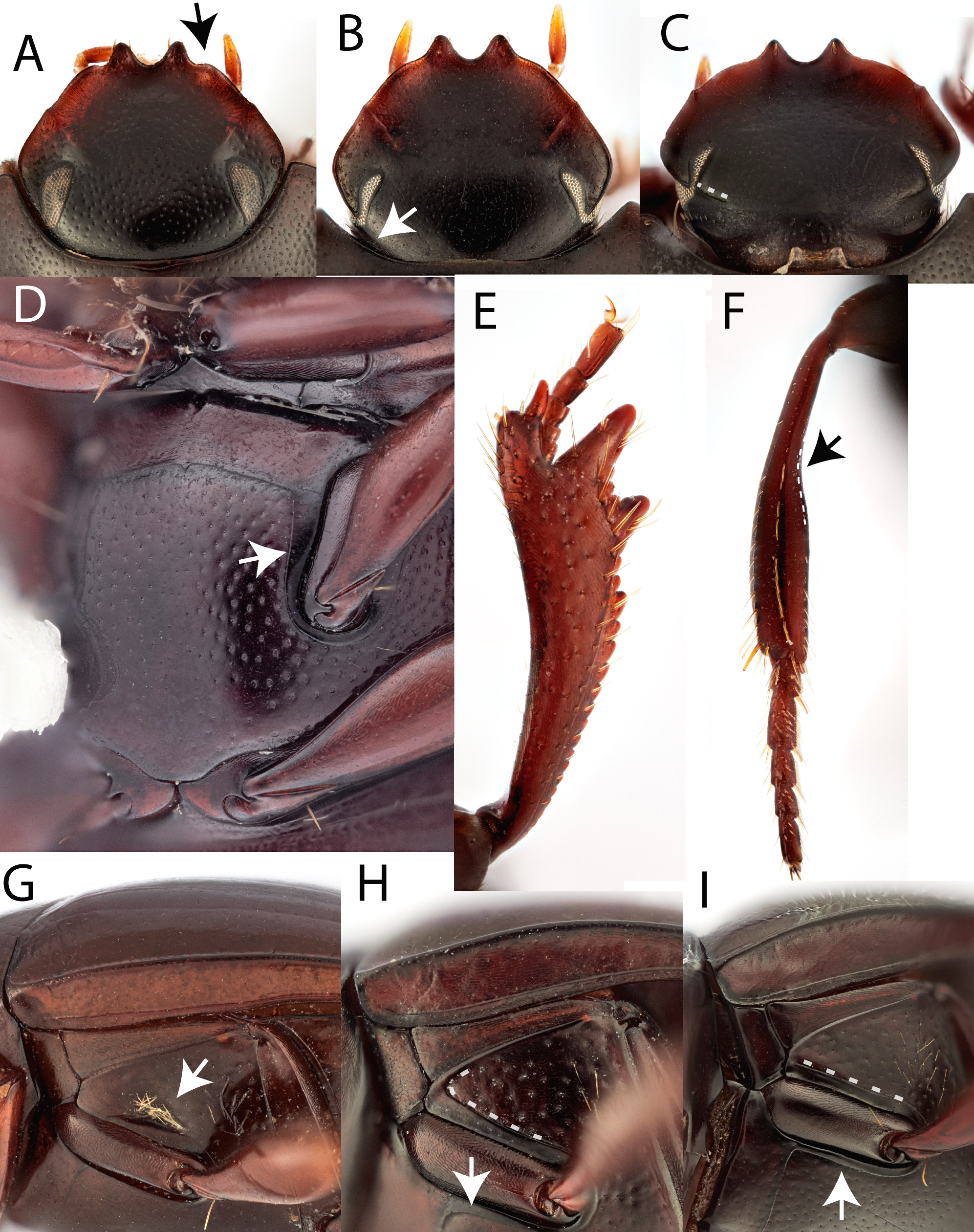
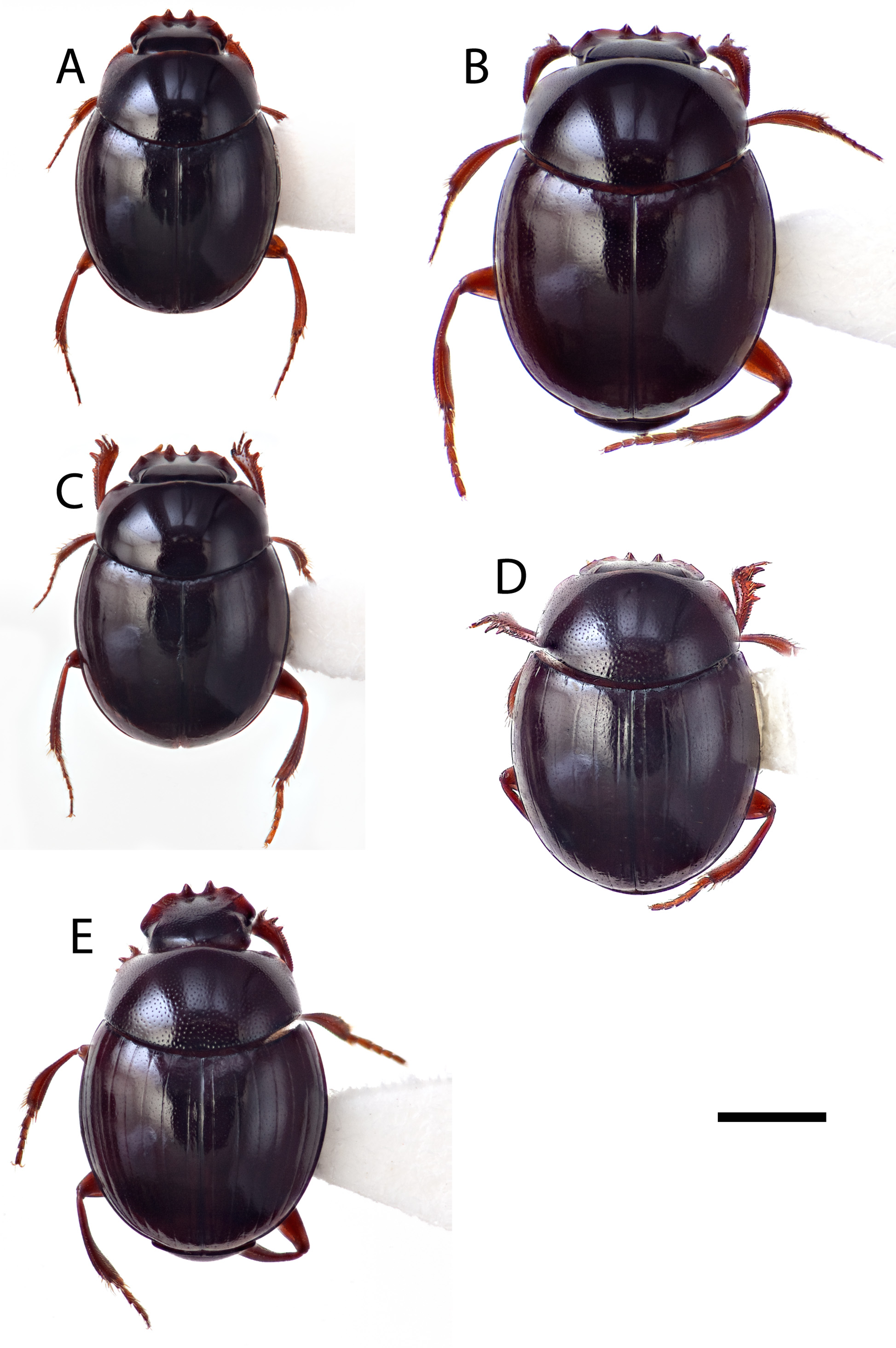
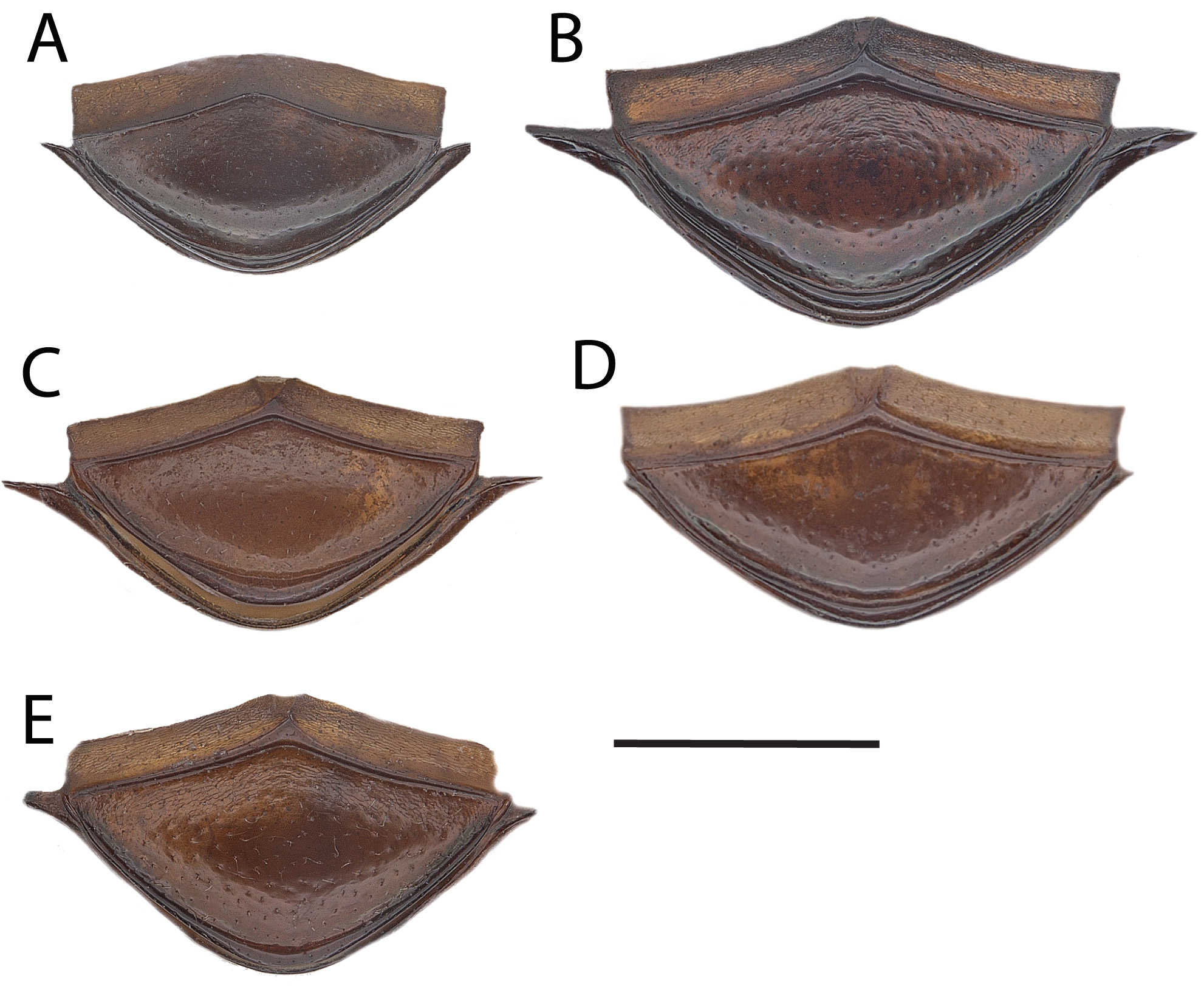
( Figs. 8C, E, I View FIGURE 8 ; 9B View FIGURE 9 ; 10B View FIGURE 10 ; 11B View FIGURE 11 )
Lepanus monteithi Matthews, 1974: 108 View in CoL .
Type material examined. Holotype: ♂ “ Iron Range, Cape York Pen. NQld 5-10 May 1968 G. Monteith ” / “rainf., human, nocturnal” / “ T. 7104” / “ Lepanus monteithi m. Det 1972 E.G. Matthews HOLOTYPE ” / “ ANIC Database No. 25 015633”, in QM [12°42’0”S, 143°16’0”E] GoogleMaps . Paratypes: “ Iron Range, Cape York Pen. NQld Apr. 28-May 4, 1968 G. Monteith ” / “ Lepanus monteithi m. Det 1972 E.G. Matthews PARATYPE ” / “ ANIC Database No. 25 058476” 1 specimen ♀ in QM [12°42’0”S, 143°16’0”E] GoogleMaps ; “ Iron Range, Cape York Pen. NQld Apr. 11-17 May1968 G. Monteith ” / “ Lepanus monteithi m. Det 1972. E.G. Matthews PARATYPE ” / “ ANIC Database No. 25 058477” 1 specimen ♀ in UQ ); “ N.Q. Iron Ra., rainforest 143, 13 x 12.45 14 June 1971 ” / “Berlesate ANIC 307 View Materials R.W. Taylor J.Feehan ” or “Berlesate ANIC 311 View Materials R.W. Taylor J.Feehan ” / “ Lepanus monteithi Det 1972 E.G. Matthews PARA- TYPE” / “ ANIC Database No. 25 015629”, 1 specimen ♂, 1 specimen ♀ in ANIC [12°42’0”S, 143°16’0”E] GoogleMaps .
Other material examined. 89specimens from10locations also examined. 11km ENE Mount Tozer ,[12°42’44”S, 143°18’37”E], 11–16.vii.1986, J.C. Cardale (25-054092 1 specimen, 25-054095 6 specimens in ANIC) GoogleMaps ; 11 km ENE Mount Tozer , [12°42’44”S, 143°18’37”E], 11–16.vii.1986, T.A. Weir (25-054087 1 specimen, 25-054089 2 specimens, 25-054091 2 specimens in ANIC) GoogleMaps ; Iron Range , Cape York Peninsula, 12°42’54”S, 143°17’12”E, 30.vi– 4.vii.1977, (T49917–T 49921 in QM) GoogleMaps ; Gordon’s Mine Area , Iron Range, 12°42’56”S, 143°17’55”E, 12–18.ii.1976, (T49899–T 49906 in QM) GoogleMaps ; 3 km ENE Mount Tozer , [12°44’0”S, 143°14’0”E], 1–4.vii.1986, T.A. Weir (25-054085 8 specimens, 25-054086 1 specimen, 25-054090 2 specimens in ANIC) GoogleMaps ; 3 km ENE Mount Tozer , [12°44’0”S, 143°14’0”E], 28.vi–16.vii.1986, T.A. Weir (25-054088 3 specimens, 25-054094 1 specimen in ANIC) GoogleMaps ; 3 km ENE Mount Tozer , [12°44’0”S, 143°14’0”E], 28.vi–4.vii.1986, J.C. Cardale (25-054093 1 specimen, 25-054098 4 specimens in ANIC) GoogleMaps ; 9 km ENE Mount Tozer , 12°43’0”S, 143°17’0”E], 5–10.vii.1986, J.C. Cardale (25-054097 2 specimens in ANIC) GoogleMaps ; 9 km ENE Mount Tozer , 12°43’0”S, 143°17’0”E], 6–10.vii.1986, T.A. Weir (25-054096 3 specimens in ANIC) GoogleMaps ; East Claudie River , 12°42’50”S, 143°17’13”E, 15 m, 10–11.xii.2010, G.B. Monteith & Aland (25- 060819 1 specimen also as COL1447 ♀, 25- 060821 3 specimens also as COL 1449–1451 1 specimen ♂, 2 specimens ♀ in ANIC) GoogleMaps ; East Claudie River , 12°42’50”S, 143°17’13”E, 8–16.xii.2010, G.B. Monteith & H. Escalona (25- 060816 1 specimen also as COL1444 ♀, in ANIC) GoogleMaps ; East Claudie River , 12°42’50”S, 143°17’13”E, 8–9.xii.2010, G.B. Monte- ith & Aland (25- 060818 1 specimen also as COL1446 ♀ in ANIC) GoogleMaps ; East Claudie River , 12°42’50”S, 143°17’13”E, 9–10.xii.2010, G.B. Monteith & Aland (25- 060817 1 specimen also as COL1445 ♀ in ANIC) GoogleMaps ; East Claudie River , 12°42’50”S, 143°17’13”E, 9–15.xii.2010, G.B. Monteith & H. Escalona (25- 060814 1 specimen also as COL1442 ♂ in ANIC) GoogleMaps ; Gordons Creek , 12°42’47”S, 143°19’12”E, 15 m, 11–12.xii.2010, G.B. Monteith (25- 060820 1 specimen also as COL1448 ♂ in ANIC) GoogleMaps ; Gordons Mine Area , Iron Range, [12°43’0”S, 143°18’0”E], 100m, 12–18.ii.1976, G.B. Monteith (25-015617 2 specimens, 25-015618 6 specimens, 25-015634 1 specimen, 25-015635 1 specimen, 25-015636 1 specimen, 25-015637 1 specimen, 25-015640 2 specimens in QM) GoogleMaps ; Iron Range , Cape York Peninsula (general), [12°44’0”S, 143°17’0”E], 15–21.iv.1977, R.I. Storey (25-054100 3 specimens in QDPC) GoogleMaps ; Iron Range , Cape York Peninsula (general), [12°44’0”S, 143°17’0”E], 27–30.iv.1973, G.B. Monteith (25-058583 2 specimens in QDPC) GoogleMaps ; Iron Range , Cape York Peninsula (general), [12°44’0”S, 143°17’0”E], 50 m, 30.vi–4.vii.1977, G.B. Monteith (25-015623 2 specimens, 25-015626 1 specimen, 25-015628 2 specimens, 25-015625 2 specimens in QM) GoogleMaps ; Lamond Hill , 12°43’8”S, 143°17’31”E, 100 m, 10.xii.2010, G.B. Monteith & H. Escalona (25- 060815 1 specimen in ANIC also as COL1443 ♂) GoogleMaps ; West Claudie River , [12°45’0”S, 143°14’0”E], 24.x.1992, T.A. Weir & P. Zborowski (25-023715 1 specimen in ANIC) GoogleMaps ; West Claudie River , [12°45’0”S, 143°14’0”E], 24.v.1974, A. & M. Walford-Huggins (CMNEN-00030606-00030608 in CMNC) GoogleMaps .
Description. Uniformly dark brown. Antennal clubs with apical 2 segments white, basal segment grey.
Total length: 2.7–3.2 mm. Holotype measurements: total length 3.0 mm, elytral width 2.0 mm.
Male. Head. Surface with fine punctation, short basal carina present only adjacent to eyes. Clypeal edge normal, without projection lateral to teeth. Genal angle weakly defined. Dorsal part of the eyes narrow, separated by an interocular space approximately 21–22 times the eye width (43:2). Head 1.4 x wider than long (57:40).
Prothorax: Pronotal surface with light punctation. Anterior angles obtuse and blunt. Basal angles rounded and obtuse. Punctures along the basal margin absent. Pronotum 1.55 x wider than long (47:30).
Elytra: Surface smooth with superficial striae; intervals finely punctate. Striae 6 and 7 extending to elytral base. Elytra 1.5 x wider than long (60:40)
Legs: Protibiae with 2 teeth on outer edge, front edge deeply angulate. Apical digit long and parallel sided with a rounded apex with a very small comb of stout setae, and bearing a short spur on the outer apical angle. Metatibiae with a notch on the inner edge.
Abdomen: Pygidium simple, smooth, often finely reticulate basally, finely punctate and slightly convex. Abdominal ventrites reticulate right across.
Pterothorax: Medial lobe of metaventrite very finely punctate and margin between the mesocoxae virtually absent. Lateral lobe of metaventrite finely punctate, with inner border beside mesocoxae anteriorly straight, lateral border virtually absent. Mesoventrite notched anteriorly. Mesoventrite smooth. Metanepisternum reticulate.
Aedeagus: Small tufts of setae projecting from apices of both right and left parameres, left paramere somewhat spatulate.
Female. Metatibiae without a notch on the inner edge. Three stout setae on apical digit of protibiae in the same plane. Otherwise as per L. monteithi species group.
Distribution. Known from the rainforests of the Iron Range area from Mount Tozer east through the valleys of the West and East Claudie Rivers to as far east as Gordons Creek within the Cape York Peninsula bioregion ( Fig. 12A View FIGURE 12 ). This species appears to be a short range endemic and has only been collected within a 30 km diameter area.
Comments. The majority of specimens have been collected in pan traps, berlesed litter and in pitfall traps baited with human faeces. This species appears to be a generalist as it has also been collected in pitfall traps baited with mushroom, banana, and dung.
Matthews (1974) mistakenly described the species as having 3 protibial teeth but the holotype (QM T7104) has only 2 tibial teeth (see Fig. 8I View FIGURE 8 ). Matthews’ species concept of L. monteithi was derived from examining a combina- tion of specimens of L. monteithi and L. geoffi new species as some of the paratype series of L. monteithi are L. geoffi . These species are not only superficially similar but also occur in the same area. They can be distinguished from each other by number of protibial teeth, presence/absence of a setose pit on the metaventrite, and shape and setation of the male genitalia. The outline of the protibia and parameres illustrated for L. monteithi (see Figs 184, 300–301 of Matthews (1974)) match more closely L. geoffi (see Fig. 10A View FIGURE 10 ). We ignore the written the description and illustrations of L. monteithi in Matthews (1974: 108) and rely solely on the holotype to ground our species concept and redescription of L. monteithi . Sequences have been generated from multiple specimens including from East Claudie River (25- 060814, 25- 060816 –17, 25- 060819), Gordons Creek (25- 060820), and Lamond Hill (25- 060815) and show minimal sequence variation but are distinct from all other species in the L. monteithi species group. The phylogeny of Gunter et al. 2019 included all five species in the species group with L. monteithi forming a sister relationship with L. reidi .


No known copyright restrictions apply. See Agosti, D., Egloff, W., 2009. Taxonomic information exchange and copyright: the Plazi approach. BMC Research Notes 2009, 2:53 for further explanation.
|
Kingdom |
|
|
Phylum |
|
|
Class |
|
|
Order |
|
|
Family |
|
|
Genus |
Lepanus monteithi Matthews, 1974
| Gunter, Nicole L. & Weir, Thomas A. 2019 |
Lepanus monteithi Matthews, 1974: 108
| Matthews, E. G. 1974: 108 |