
Habronestes grahami, Baehr, 2003
|
publication ID |
https://doi.org/ 10.3853/j.0067-1975.55.2003.1389 |
|
persistent identifier |
https://treatment.plazi.org/id/03FA87BC-5950-FF8E-FE82-FB52FE13F813 |
|
treatment provided by |
Felipe |
|
scientific name |
Habronestes grahami |
| status |
sp. nov. |
Habronestes grahami View in CoL n.sp.
Figs. 64 View Figs , 88, 89 View Figs , 102 View Figs , 129, 130 View Figs , 140 View Figs
Type material. HOLOTYPE 3: NSW, Mount Brown Rd (0.1 km N from intersection at Mt Brown) 28°37'S 152°43'E, Richmond Range SF, 480 m, North East Forests Biodiversity Study ( NSW NPWS) G/C, AM KS83929 GoogleMaps . PARATYPES: 1♀ as holotype, AM KS36027 ; 13, 1♀, 0.5 km from Wheatley Ck Rd on Camp Ck Rd , leasehold land, 28°47'0"S 152°19'29"E, 4.ii–9.iv. 1993, 550 m, G/C, AM KS36270 GoogleMaps . 1 ♀, 233, 240 m E of jnctn of Kunderang East & Kunderang West Rds , 30°48'53"S 152°2'9"E, 4.ii–9.iv. 1993, 900 m, G/C, AM KS39106 GoogleMaps ; 3 33 Barrington Tops SF, 1.3 km along Bungaree Trail from Barrington Tops Forest Rd, 31°56'44"S 151°21'9"E, 4.ii–9.iv.1993, 1180 m, G/C, AM KS39460 GoogleMaps ; 2333 Beaury SF, Rocky Waterholes Rd, 28°32'49"S 152°20'11"E, 4.ii– 9.iv. 1993, 705 m, G/C, AM KS36148 GoogleMaps ; 233 Bondi SF, S of Bombala, 37°8'S 149°9'E, 27.x.1980, Woodlot Survey , AM KS45436 GoogleMaps ; 13 25.x.1980, litter, open forest, WL1 DIV5, Woodlot Survey, G. Gowing et al., AM KS11003 ; 233 DIV3, further as previous, AM KS11007 ; 13 DIV 4, AM KS11025 ; 1♀ Boorook SF, 1 km E of main road, 28°49'20"S 152°11'14"E, 4.ii–9.iv. 1993, 900 m, G/C AM KS36309 GoogleMaps ; 1 ♀ Boundary Ck SF, SW along Boundary Ck Rd from jnctn of Dungel & Shannon Ck Rds, 29°56'48"S 152°33'27"E, 4.ii–9.iv. 1993, 600 m, G/C, AM KS39030 GoogleMaps ; 13 Bulga SF, Padmans Rd, nr intersection of Pole Dump Rd, 31°36'58"S 152°10'39"E, 4.ii–9.iv. 1993, 730 m, G/C, AM KS39462 GoogleMaps ; 1 ♀ Bulls Ground SF nr Wauchope, 31°33'S 152°38'E, 10.ii.1991, dry euc. open forest, Plot 6B3–burnt, 6–13 Feb 1991, A. York, NSW Forestry , AM KS43350 GoogleMaps ; 2 33 Carrai SF, Block & Tackle Ridge, 500 m from Carrai Rd, 30°57'34"S 152°23'41"E, 4.ii–9.iv. 1993, 540 m, G/C, AM KS39461 GoogleMaps ; 1 3 Chaelundi SF, 1.2 km W along Stockyard from Chandlers Ck, 29°56'48"S 152°31'46"E, 4.ii–9.iv. 1993, 450 m, G/C, AM KS39458 GoogleMaps ; 1 3 Dorrigo NP, off Dorrigo-Bellingen Rd, about 20 km from Bellingen (to E of rd) about 500 m S of Newell Falls , 30°23'55"S 152°44'56"E, 4.ii–9.iv.1993, 410 GoogleMaps
m, G/C, AM KS35632; 233 East Kunderang Trail, 1.35 km E of West Kunderang Trail, 30°48'41"S 152°2'55"E, 4.ii–9.iv. 1993, 890 m, G/C, AM KS55993; 233 Gilgurry SF, Rivertree Fire Trail, on ridge 2 km NNE from t/o, 28°45'18"S 152°15'52"E, 4.ii–9.iv. 1993, 770 m, G/C, AM KS36247; 13 Glen Davis, 33°8'S 150°17'E, 31.v.1982, litter, 19 May– 14 Jun 1982, B. Henke, AM KS10106; 3♀♀ Mt Hyland Nature Reserve, 1.9 km N on Chaelundi Rd from Big Bull Rd, 30°8'55"S 152°26'36"E, 4.ii–9.iv.1993, 1160 m, G/C, AM KS35614; 1 3 Mt Kosciusko, Island Bend, 36°19'S 148°29'E, 24.xi. 1952, 455 m, J.Armstrong, AM KS15703; 233 Nadgee Nature Reserve, 37°22'S 149°55'E, 24.v.1978, in litter, 24 Feb–24 Jul 1978, G. Gowing, AM KS1610; 1 ♀ Ramornie SF, Mt Tindal Rd, 29°41'49"S 152°35'0"E, 4.ii–9.iv. 1993, 490 m, G/C, AM KS39133; 1♀ Ramornie SF, track off Mt Tindal Rd, 29°42'41"S 152°37'36"E, 4.ii– 9.iv. 1993, 220 m, G/C, AM KS39130; 3♀♀ Ramornie SF, track off Mt Tindal Rd, 29°42'38"S 152°38'9"E, 4.ii–9.iv. 1993, 200 m, G/C, AM KS39132; 2♀♀ Ramornie SF, T-ridge Rd, 29°43'13"S 152°33'38"E, 4.ii– 9.iv. 1993, 300 m, G/C, AM KS39131; 13 Richmond Range SF, jnctn of Wattle Ck Rd and Wattle Ck, 28°38'9"S 152°46'40"E, 4.ii–9.iv. 1993, 130 m, G/C, AM KS36044; 13 Ridge between Camp Ck and Stydgy Ck, leasehold Land, 28°46'18"S 152°18'8"E, 4.ii–9.iv. 1993, 640 m, G/C, AM KS36241; 233 Round Hill, Euabalong, 32°58'S 146°9'E, 13.v.1972, M. R. Gray, AM KS49141; 1♀, 13, Royal National Park, Sydney, 34°8'S 151°4'E, 22.vi.1969, R. Mascord, AM KS15683; 333 Stewarts Brook SF, 0.7 km W along unnamed logging track from Omadale Brook Rd, 31°54'16"S 151°23'36"E, 4.ii–9.iv.1993, 1250 m, G/C, AM KS39459; 1♀ Styx River SF off Cunnawarra Trail, about 2 km N Cunnawarra Ck, 30°32'49"S 152°20'16"E, 4.ii–9.iv.1993, 1070 m, G/C, AM KS35626; 233 Washpool NP, North West Fire Trail, 29°27'36"S 152°17'25"E, 4.ii– 9.iv. 1993, 950 m, G/C, AM KS36406; 2333 Washpool NP, North West Fire Trail, 29°27'30"S 152°16'52"E, 4.ii–9.iv. 1993, 950 m, G/C, AM KS36417; 13 20 km N of Burcher on road to Manna Mountain, 33°22'12"S 147°15'2"E, 25.iii.1996, roadside corridor vegetation N5 trap B1, 21–28 Mar 1996, D. Smith & R. Harris, AM KS56121; 1 3 Booti bicornis n.sp.; (76, 77) Habronestes monocornis n.sp.; (78, 79) Habronestes raveni n.sp. Scales 0.5 mm.
Booti NP, 32°16'15"S 152°31'42"E, 25.xi.1997, L.Wilkie, AM KS55939 GoogleMaps ; 13, AM KS55953 ; 13, as previous, AM KS55959 ; 1♀ as previous but 13.xii.1996, AM KS55968 ; 1♀ Mummel Forest Rd, 7.6 km N of Enfield Forest Rd, Enfield SF, 31°17'S 151°51'E, 9.iv.1993, 1340 m, G/C, AM KS56063 GoogleMaps ; 13 Myall Lakes NP, 32°29'22"S 152°23'53"E, 13.iv.1998, L. Wilkie, AM KS56108 GoogleMaps ; 1♀ as previous, AM KS56109 ; 13 as previous but 24.v.1998, AM KS56045 ; 1♀, as previous, AM KS56043 ; 1♀ Wyrrabalong NP, 33°16'44"S 151°32'51"E, 27.xi.1997, L. Wilkie, AM KS56011 GoogleMaps ; 13 Wyrrabalong NP, 33°16'47"S 151°32'40"E, 2.v.1997, L.Wilkie, AM KS55933 GoogleMaps . The following in AM with same data as previous: 13 KS56036; 13 KS56038; 13 KS56118; 13 15.iv.1998, KS55987; 13 23.v.1998, KS56072; 1♀, AM KS56064 . ACT: 1♀, 933 Tidbinbilla Nature Reserve , 35°28'S 148°52'E, 9.iii.1978, PO GoogleMaps ref site 11, P. Ormay, AM KS13834 .
Diagnosis. Eyes equal-sized, in 2 rows each with 4 eyes, both rows procurved.Abdomen with 2 pairs of white patches on anterior part and 1 or 2 patches in front of spinnerets. LTA with a thick, short vertical stalk and irregular horizontal plate, bird head shape retrolaterally. Epigyne with scape originating from central opening at posterior margin.
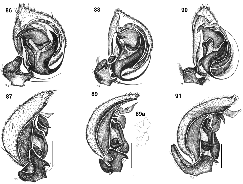
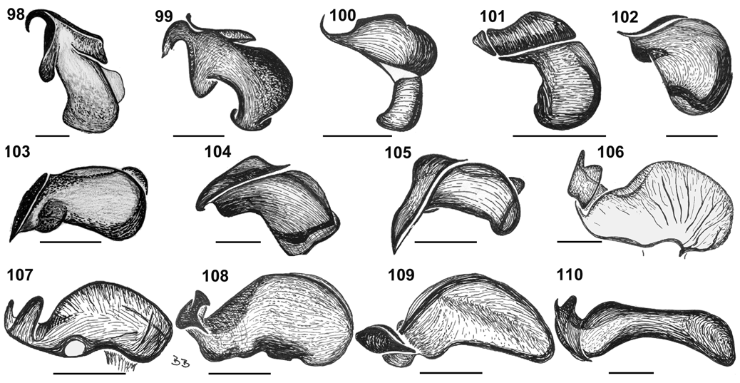
Description. Male (holotype). Total length 5.20; carapace 2.84 long, 2.20 wide; 0.96 high; cl/cw 1.29; sternum 1.24 long, 1.04 wide; sl/sw 1.19. Abdomen 2.36 long, 1.80 wide. Colour. Carapace, sternum sepia brown, iridescent; chelicerae reddish brown; maxillae and labium pale brown, distally white. Abdomen sepia brown with 2 pairs of white patches on anterior part and 2 patches in front of spinnerets ( Fig. 67 View Figs ); laterally with 2 long white patches equal in length; ventrally with 1 longitudinal white stripe from epigastric fold to near tracheal spiracle. Legs orange brown; clearly annulated; legs I–IV with white coxa, prolateral suture sepia brown, medium brown trochanter, proximal margin of femora sepia brown, proximal ½ white and distal ½ sepia brown, darker brown lateral stripes on patella and tibia; femur I with u-shaped pattern. Eyes. In 2 rows each with 4 eyes, both rows procurved. Nearly equal-sized. Eye group width 0.50 of headwidth; AME 0.12; ALE 0.12; PME 0.13; PLE 0.13; AME–AME 0.04; AME–ALE 0.04; ALE–PLE 0.04; PME–PME 0.06; PME–PLE 0.10. MOQ: AME–PME 0.38; AME–AME 0.28; PME–PME 0.32. Clypeus & chilum. Clypeus 0.72 high; chilum undivided short. Abdomen. Oval; with stout bristles in front of tracheal spiracle. Legs. Length formula 4123; femora I, II with 1 row and femora III, IV with 2 rows of long thin setae ventrally. Male palp ( Figs. 88, 89, 89a View Figs , 102 View Figs ). RCF deep, almost running the entire cymbium length; cymbium with a few strong spines apically. LTA with a thick, short, vertical stalk and irregular horizontal plate; DTA with a thin stalk; VTA sickle-shaped, long, with sharp tip. Tibiae short; DTiA with sharp tip, as long as tibia; VTiA ( Fig. 89 View Figs ).
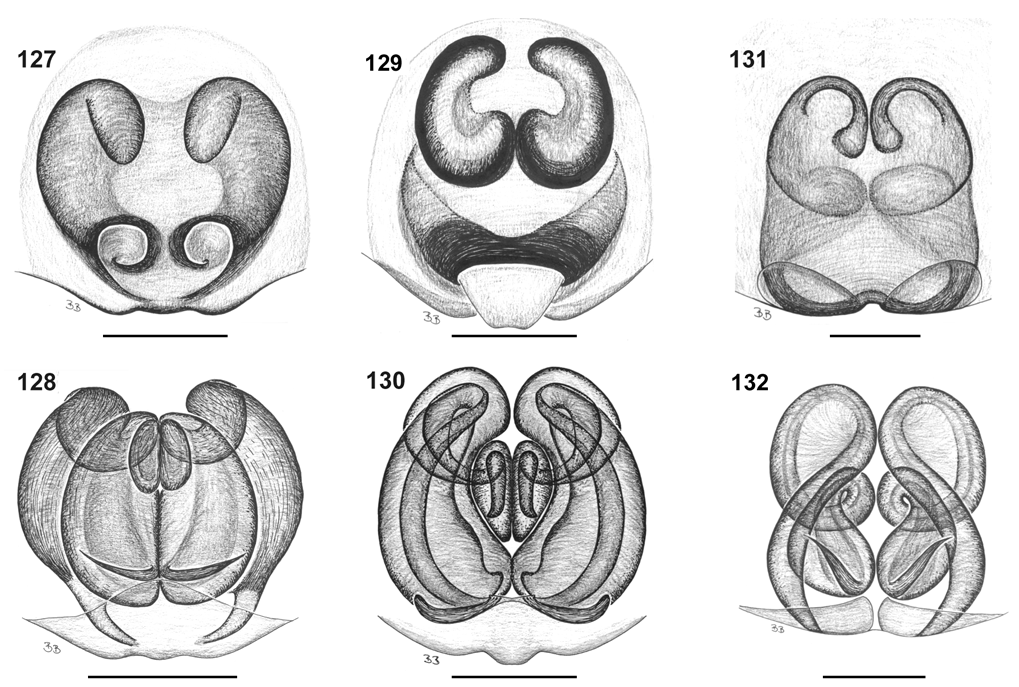
Female (paratype AM KS35626). Total length 5.80; carapace 2.68 long, 1.72 wide; 1.08 high; cl/cw 1.20; sternum 1.20 long, 1.12 wide; sl/sw 1.07. Abdomen 3.12 long, 2.00 wide. Colour. Same as male. Eyes. Eye group width 0.51 of headwidth; AME 0.12; ALE 0.12; PME 0.14; PLE 0.14; AME–AME 0.04; AME–ALE 0.04; ALE–PLE 0.04; PME–PME 0.06; PME–PLE 0.08. MOQ: AME–PME 0.34; AME–AME 0.28; PME–PME 0.34. Clypeus & chilum. Clypeus 0.6 high; chilum divided. Epigyne ( Figs. 129, 130 View Figs ). With scape originating from central opening at posterior margin. Kidney-shaped and posteriorly touching copulatory ducts are visible through the tegument. Vulva with long, spiralled copulatory ducts ending in oval, medially touching spermathecae.
Variation. Males of this widespread species show some variation in the shape of palpal tibial apophysis ( Fig. 89a View Figs ).
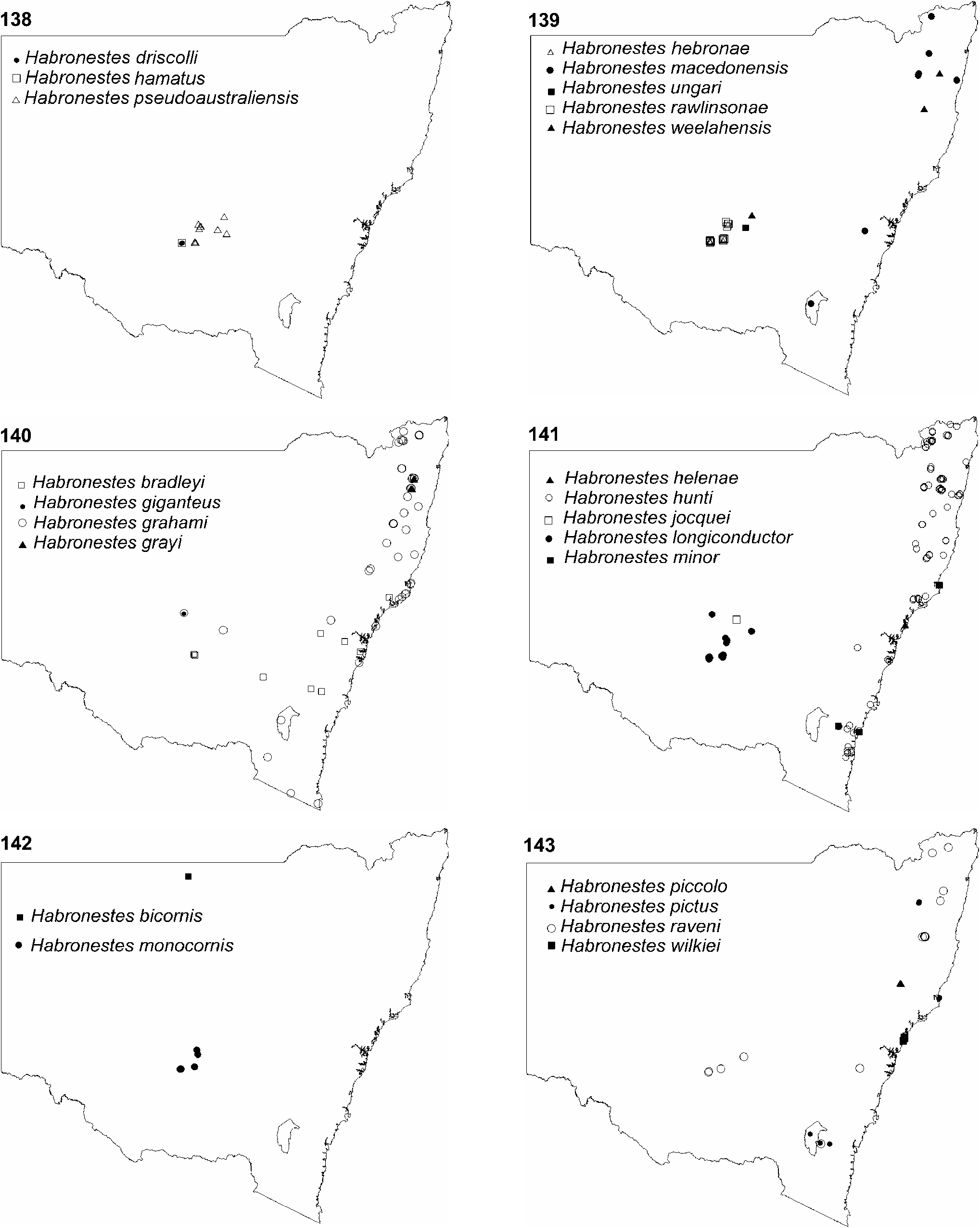
Distribution. Widespread in New South Wales and ACT ( Fig. 140 View Figs ).
Etymology. Species name is a patronym in honour of Mr Graham Milledge, the collection manager of Arachnology at the Australian Museum, who provided valuable technical assistance during this project.

| NSW |
Royal Botanic Gardens, National Herbarium of New South Wales |
| AM |
Australian Museum |
| R |
Departamento de Geologia, Universidad de Chile |
| PO |
Collection of the Zoological Institute of the Russian Academy of Sciences |
No known copyright restrictions apply. See Agosti, D., Egloff, W., 2009. Taxonomic information exchange and copyright: the Plazi approach. BMC Research Notes 2009, 2:53 for further explanation.
|
Kingdom |
|
|
Phylum |
|
|
Class |
|
|
Order |
|
|
Family |
|
|
Genus |