
Thyonella pervicax ( Théel, 1886a )
|
publication ID |
https://doi.org/ 10.5281/zenodo.195134 |
|
DOI |
https://doi.org/10.5281/zenodo.6208481 |
|
persistent identifier |
https://treatment.plazi.org/id/30710A41-1628-FFCB-FF2A-227CEADCD6B8 |
|
treatment provided by |
Plazi |
|
scientific name |
Thyonella pervicax ( Théel, 1886a ) |
| status |
|
Thyonella pervicax ( Théel, 1886a) View in CoL
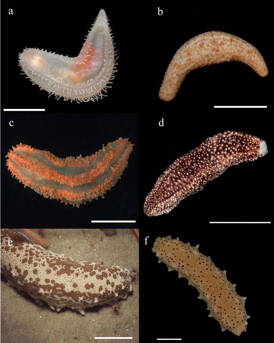
Figure 6 View FIGURE 6 b, 13
Thyone pervicax Théel, 1886a: 93 , pl. 2 fig. 3, pl. 5 fig. 9; Deichmann, 1930: 175, pl. 16 figs.9–12. Thyonella pervicax View in CoL . — Hendler et al, 1995: 264, figs 144, 179 E,F,G,H.
Material examined. USNME 16425, N.C., Raleigh Bay, Beaufort, Sta. 469, 1965. USNM E16091, Florida. 11 mile SE of Cape, 5m. USNM E19416 View Materials , off S.C., 32°36'N, 78°39'W, R/V Pierce, Sta 2F, August 21, 1977, 42m. USNM E19432 View Materials , off S.C., 32°23'N, 80°09'W, R/V Pierce, Sta 3B, Feb. 17, 1977, 13m, 2. USNM E19452 View Materials , off S.C., 32°05'N, 79°38'W, R/V Pierce, Sta 3D, Feb. 17, 1977, 33m, 2. USNM E19455 View Materials , off S.C., 32°01'N, 79°31'W, R/V Pierce, Sta 3E, August 25, 1977, 46m. USNM E22560, Georgia, 31°20’00”N, 80°17’00”W, R/V Pelican, Sta 178-15, Jan. 31, 1940, 38m, 2. USNM E22569 View Materials , Georgia, 31°59’30”N, 80°34’00”W, R/V Pelican, Sta 181-3, Feb. 3, 1940, 15m. USNM E22552, Georgia, 31°41’30”N, 80°01’00”W, R/V Pelican, Sta 179-10, February 1, 1940, 33m. USNM E22558, Georgia, 32°01’00”N, 80°16’00”W, R/V Pelican, Sta 181-7, February 3, 1940, 20m. USNM E22575 View Materials , N.C., Shacklesford Island, Sept. 12, 1928. USNM E22556, Georgia, 31° 11 00'N, 80°52’00”W, R/V Pelican, Sta 178-6, January 31, 1940, 16m. USNM E22570 View Materials , Florida, 29°40’00”N, 81°09’30”W, R/V Pelican, Sta 176-10, Jan. 25, 1940, 37m. USNM E25293 View Materials , Florida, 28°26’30”N, 80°12'W, R/V Silver Bay Sta 2032, 37m. USNM E33163 View Materials , Florida, 30°40'N, 81°11'W, R/V Delaware II, Sta 0 88, May 22, 1984, 20.1m, 2. USNM E33164 View Materials , Florida, 51.5 Nautical miles E, 29°50'N, 80°17'W, R/V Delaware II, Sta 148, April 27, 1983, 62–64m, 2. USNM E33156 View Materials , Florida, 31 Nautical miles E, 30°20'N, 80°48'W, R/V Delaware II, Sta 116, April 25, 1983, 32–35m, 4. USNM E33167 View Materials , Florida, 19.5 Nautical miles E, 28°00'N, 80°12'W, R/V Delaware II, Sta 0 40, April 22, 1983, 27.4m. USNM E33172, Florida, 37 Nautical miles E, 29°10'N, 80°17'W, R/V Delaware II, Sta 0 87, April 24, 1983, 46m. USNM E33162 View Materials , Florida, 24 Nautical miles E, 28°10'N, 80°13'W, R/V Delaware II, Sta 0 43, April 22, 1983, 27.4m, 21. USNM E33168 View Materials , Florida, 24.5 Nautical miles E, 28°15'N, 80°08'W, R/V Delaware II, Sta 0 55, April 22, 1983, 42m. USNM E33158 View Materials , Florida, 30°00’18”N, 80°32’48”W, R/V Delaware II, Sta 93, May 23, 1984, 36.6m, 6. USNM E33155 View Materials , Florida, 29 Nautical miles NE, 30°10'N, 80°49'W, R/V Delaware II, Sta 115, April 25, 1983, 27.4m, 7. USNM E33160 View Materials , Florida, 31 Nautical miles E, 30°30'N, 80°49'W, R/V Delaware II, Sta 117, April 25, 1983, 27–29m, 6. USNM E33166 View Materials , Florida, 47 Nautical miles E, 29°40'N, 80°20'W, R/V Delaware II, Sta 110, April 25, 1983, 46–48m, 3. USNM E33171 View Materials , Florida, 53.5 Nautical miles ENE, 30°00'N, 80°16'W, R/V Delaware II, Sta 141, April 27, 1983, 69.5m, 2. USNM E33165 View Materials , Florida, 49.5 Nautical miles E, 29°50'N, 80°19'W, R/V Delaware II, Sta 149, April 27, 1983, 46m. USNM E33170 View Materials , Florida, 33 Nautical miles E, 29°40'N, 80°36'W, R/V Delaware II, Sta 112, April 25,1983, 27.4m, 2. USNM E33161 View Materials , Florida, 30° 09 54'N, 80° 30 12'W, R/V Delaware II, Sta 0 92, May 23, 1984, 38.4m, 13. USNM E33159 View Materials , Florida, 29°19’48”N, 80°29’54”W, R/V Delaware II, Sta 0 74, May 21, 1984, 33m, 15. USNM E33169 View Materials , Florida, 29°50’06”N, 81°14’00”W, R/V Delaware II, Sta 0 83, May 22, 1984, 14.6m. USNM E33157 View Materials , Florida, 22.5 Nautical Miles ENE, 30°00'N, 80°52'W, R/V Delaware II, Sta 114, April 25, 1983, 27m, 13. USNM E39039, Florida, North of Cape Canaveral, 28°23’54”N, 80°16’42”W, R/V Oregon II Sta 45125, 27.4m, 3. USNM E39040, Florida, East of Cape Canaveral, 28°14’54”N, 80°14’24”W, R/V Oregon II Sta 45126, March 20, 1987, 27.4m, 4. USNM E39039, Florida, North of Cape Canaveral, R/V Oregon II Sta 45125 March 20, 1987, 27.4m, 3. USNM E46901 View Materials , N.C., Surf City, Topsail Island, 2. SERTC 1043, off Charleston Harbor, SC, 32°30.18'N, 78°57.52'W, 40.5–41.1 m, coll. SERTC Staff, June 2 2004. SERTC 1044, off Charleston Harbor, SC, 32°36.12'N, 79°04.16'W, 35.1–35.7 m, coll. SERTC Staff, June 2 2004. SERTC 1045, off Ossabaw Island, GA, 31°52.51'N, 79°46.71'W, 38.1– 39 m, coll. SERTC Staff, June 3 2004. SERTC 2100, 41.5 miles @ 128 degrees of Charleston Light, SC, 32°19.7'N, 79°12.5'W, 40 m, coll. GML Staff, March 20 1976. SERTC 2103, 55.5 miles @ 109 degrees of Charleston Light, SC, 32° 30.5N, 78° 57.5W, 40 m, coll. GML Staff, March 31 1979. SERTC 2104, 43.6 miles off Charleston Light, SC, 32°04.7'N, 79°33.7'W, 40 m, coll. GML Staff, April 28 1981. SERTC 2133, off Edisto Island, SC, 32°12.33'N, 79°42.16'W, 30.5 m, coll. SERTC Staff, April 29 2005. SERTC 2280, off Charleston Harbor, SC, 32°23.9'N, 79°06.4'W, 37.5 m, coll. GML Staff, October 26 1974. DML 3105, 34 º28’N, 76º09.4’W, 37 m. DML 3106, 34 º29.3’N, 76º11.2’W, 37 m.
Diagnosis. Small, burrowing form, 40–70 mm long. Color mottled white or tan and light to dark brown, with conspicuous scattered brown patches. Body tapering gently toward blunt ends. Conical podia uniformly distributed over body surface, retracted to low warts in preserved specimens. Body wall thick, rigid, filled with ossicles consisting of knobbed buttons of two sizes (60–90 μm and 35–55 μm) and shallow cups (40–60 μm) with 10–12 marginal teeth; no perforated plates.
Distribution. MA to E and W FL, Gulf of Mexico, TX, Mexico, Brazil.
Habitat. Burrows in soft, sandy sediments, also on shell and quartz sand bottom covered with algae and seagrass. 6– 70 m.
Remarks. Like T. gemmata , this species is locally very common ( Hendler et al., 1995).
No known copyright restrictions apply. See Agosti, D., Egloff, W., 2009. Taxonomic information exchange and copyright: the Plazi approach. BMC Research Notes 2009, 2:53 for further explanation.
|
Kingdom |
|
|
Phylum |
|
|
Class |
|
|
Order |
|
|
Family |
|
|
Genus |
Thyonella pervicax ( Théel, 1886a )
| Pawson, David L., Pawson, Doris J. & King, Rachael A. 2010 |
Thyone pervicax Théel, 1886a : 93
| Hendler 1995: 264 |
| Deichmann 1930: 175 |
| Theel 1886: 93 |