
Oxypoda ( Baeoglena ) kuehnelti SCHEERPELTZ, 1963
|
publication ID |
https://doi.org/10.21248/contrib.entomol.69.1.001-032 |
|
publication LSID |
lsid:zoobank.org:pub:016AAB3F-8AE2-4759-B95A-DEAA074768CD |
|
persistent identifier |
https://treatment.plazi.org/id/320587A7-EB54-1D70-FF27-FC902B07E02F |
|
treatment provided by |
Felipe |
|
scientific name |
Oxypoda ( Baeoglena ) kuehnelti SCHEERPELTZ, 1963 |
| status |
|
Oxypoda ( Baeoglena) kuehnelti SCHEERPELTZ, 1963 View in CoL
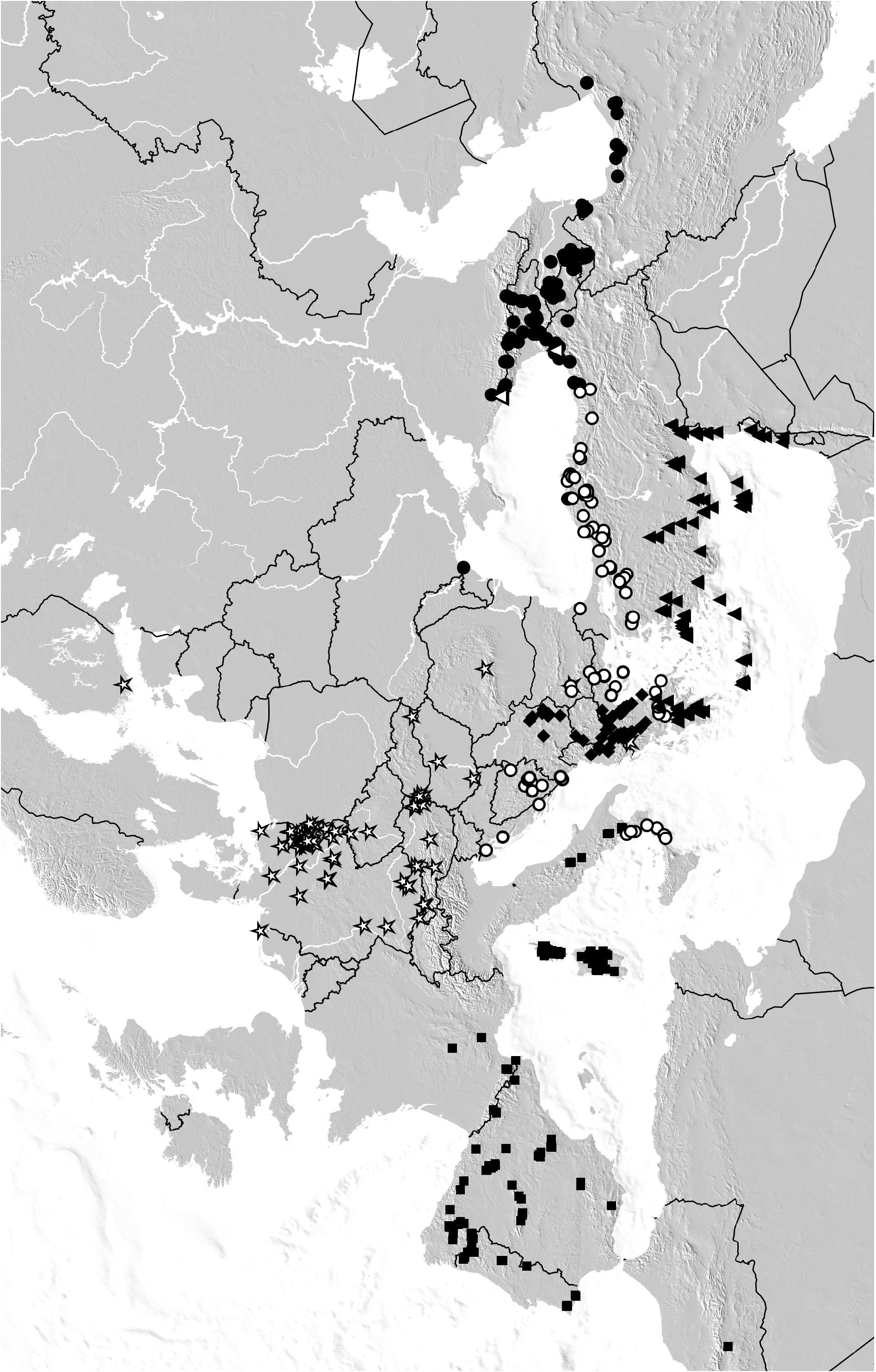
( Figs 29–39 View Figs 23–36 View Figs 37–39 , Maps 1 View Map 1 , 5 View Map5 )
Oxypoda ( Baeoglena) Kühnelti SCHEERPELTZ, 1963: 449 View in CoL ff.
Type material examined: Lectotype, present designation: “ / Prioni, 1600 m, Olymp, 3.V.60 / Griechenland, W. Kühnelt / Oxypoda ( Baeoglena) Kühnelti nov. spec. / ex coll. Scheerpeltz / Typus Oxypoda ( Baeoglena) Kühnelti O. Scheerpeltz / Oxypoda praecox Erichson, M. Tronquet det. 2000 / Lectotypus Oxypoda kuehnelti Scheerpeltz , desig. V. Assing 2018 / Oxypoda kuehnelti Scheerpeltz , det. V. Assing 2018” ( NHMW) . Paralectotype [dissected prior to present study; specimen completely bleached, pale-yellow]: same data as lectotype ( NHMW) .
Comment: The original description is based on “1, 1, Typen” (i.e., syntypes) from “Prioni ... im Olymp- Massiv” ( SCHEERPELTZ 1963). The male is designated as the lectotype.
Material examined: Serbia: 1, 3, Niš region, Suva Planina, Bojanine Voda env., 43°13.4'N, 22°06.2'E, 890 m, sifted, 2.VII.2006, leg. Hlaváč (cAss); 3 GoogleMaps , same data, but 1100–1200 m, 3.VII.2006 (cAss); 5 exs. GoogleMaps , Niš region, Suva Planina, Bojanine Voda env., 43°13.4'N, 22°06.2'E, 850 m, forest litter sifted, 2.VII.2006, leg. Cooter (cAss); 1 ex. GoogleMaps , Suva Planina , Bojanine Voda env ., 1100 m, 3.VII.2006, leg. Cooter (cAss); 1, 1, Suva Planina, Smrdan, 1650 m, 17.V.2007, leg. Stévanović (cAss); 2, Svrljiške Planina, Lozan, Bare , 10.VII.2009, leg. Stévanović (cAss); 1 ex. , 2, Svrljiške Planina, Ribarska korita, 3.VII.2006, leg. Cooter (cAss); 2, 5, Surijiške Planina, Prekonoge env., 4.VII.2006, leg. Hlaváč (cAss); 1, 4 , Niš region, Babička Gora, Donji Dušnik , 43°09'N, 22°05'E, 800 m, beech and oak forest, 5.VII.2006, leg. Hlaváč (cAss); 5 exs. GoogleMaps , Niš region, Babička Gora, Siroka Padina , 750 m, beech litter, 5.VII.2006, leg. Cooter (cAss); 1, Babička Gora, Zelenika, 20.VII.2006, leg. Stevanovič (cFel); 1, 1, Kapaonik mts. , Jaram , 1550 m, 6.VI.2009, leg. Stévanović (cAss); 1, Javorak Planina, Grza, 720 m, 8.IV.2007, leg. Stévanović (cAss); 1, 2 exs., Rtanj Planina , 600 m, 27.V.1984, leg. Besuchet ( MHNG, cAss) .
Albania: 3 exs., Tiranë, 10 km ENE Tiranë, Mali Dajti , 41°22'N, 19°55'E, 1160 m, mixed beech forest, litter sifted, 21.V.2010, leg. Assing (cAss) GoogleMaps ; 3 exs., Elbasan, 13 km SE Elbasan, Mali i Shpatit , 41°03'N, 20°13'E, 1500 m, beech forest margin, sifted, 22.V.2010, leg. Assing (cAss) GoogleMaps ; 6 exs., Librazhd, 25 km ESE Elbasan, Mali i Polisit , 41°04'N, 20°22'E, 1700 m, old beech forest with snow, litter sifted, 23.V.2010, leg. Assing (cAss) GoogleMaps ; 12 exs., Korçë, 37 km W Korçë, Mali i Ostrovikës , 40°40'N, 20°21'E, 1340 m, beech forest margin, beech litter and fern roots sifted, 26.V.2010, leg. Assing (cAss) GoogleMaps ; 19 exs., Korçë, 10 km S Korçë, Mali i Gramozit , 40°32'N, 20°48'E, 1570 m, beech forest with poplar and juniper, sifted, 27.V.2010, leg. Assing (cAss, MNB) GoogleMaps ; 7 exs., Korçë, 10 km S Korçë, Mali i Gramozit , 40°31'N, 20°48'E, 1550 m, moist beech 0.1 mm GoogleMaps .
forest margin, beech, fern, etc. sifted, partly near temporary stream, 27.V.2010, leg. Assing (cAss); 10 exs., Mount Tomorr [ 40°42'N, 20°08'E], Kulmak pass, V.1931, leg. Winkler ( NHMW, cAss) GoogleMaps .
Macedonia: 6, Bistra Mts., Mavrovo env., 1540 m, sifted, 16.VI.2011, leg. Hlaváč (cAss) ; 1, Šar planina, Popova Šapka , 16.VII.1935, leg. Fodor ( HNHM); 6 exs. , Šar planina, Popova Šapka, 5–11.VI.1955, leg. Schubert ( NHMW); 1, 1, E Ohrid lake, Galičica , 1800- 2000 m, beech litter sifted, 18–21.VII.1964, leg. Knappe ( NHMW) .
Greece: 17 exs., N-Pindos, ca. 40 km NNE Konitsa, Oros Gramos range, S Oros Arénes, SE Aetomilitsa , 40°18'N, 20°54'E, 1720 m, beech forest, 25.V.2005, leg. Assing (cAss) GoogleMaps ; 55 exs., N-Pindos, ca. 40 km NNE Konitsa, Oros Gramos range, S Oros Arénes, SE Aetomilitsa , 40°18'N, 20°53'E, 1650 m, beech forest, sifted, 25.V.2005, leg. Assing (cAss) GoogleMaps ; 1 ex., same data, but grass near forest margin sifted (cAss) GoogleMaps ; 2 exs., Ioannina, ca. 15 km SE Konitsa, Oros Timfi , W Vrisochori , 39°59'N, 20°53'E, 1280 m, beech forest, 26.V.2005, leg. Assing (cAss); 1, Ioánnina, Oros Smólikas, above Palioseli, 40°04'N, 20°53'E, 1630 m, subterranean pitfall trap, 17.VI.2007 – 16.VI.2008, leg. Giachino & Vailati (cAss); 1, Ioánnina, Oros Timfi, road to Vovoússa, 1480 m, subterranean pitfall trap, 27.VI.2004 – 16.VI.2005, leg. Giachino & Vailati (cAss); 2 exs., Ioánnina, Notia Pindos , Anilio, road to ski resort , 39°45'N, 21°12'E, 16.IV.2018, leg. Schülke ( MNB, cAss); 1, Ioánnina, Notia Pindos, Metsovo GoogleMaps , 1400 m, 24.VI.1997, leg. Bayer ( MNB) ; 4, 2, Flórina , 15 km W Flórina, Oros Varnous , 40°48'N, 21°15'E, 1600 m, 23.IV.2000, leg. Assing & Wunderle (cAss, cWun); 3, 2 GoogleMaps , 6 exs., Flórina , 15 km S Flórina, Oros Vitsi , 40°39'N, 21°23'E, 1850–1880 m, 25.IV.2000, leg. Assing & Wunderle (cAss, cWun); 1, Flórina, Oros Vitsi , above Drosopigi, 40°39'N, 21°24'E, 1340 m, subterranean pitfall trap, 19.VI.2007 – 17.VI.2008, leg. Giachino & Vailati (cAss); 2, 6 exs., Flórina , 40 km NE Flórina, Oros Voras , 40°53'N, 21°48'E, 1650 m, 22.IV.2000, leg. Assing & Wunderle (cAss, cWun); 2, 2, Makedhonía, Imatia, Vermio, above Seli, 40°33'N, 22°00'E, 1500 m, 11.IV.1998, leg. Assing & Schülke (cAss, MNB) GoogleMaps ; 2 exs., Makedhonía, Imathia, Vermio, NW Kato Vermio , 1300 m, 6.VI.1999, leg. Brachat ( MNB, cAss) ; 8 exs., Sedi near Katovermio , 1300–1500 m, V.1979, leg. Franz ( NHMW) ; 1, 1, Makedhonía, Grevena, Smolikas Oros, SW Smixi, 1450 m, 18.VI.2002, leg. Brachat (cAss); 1, 1, Makedhonía, Kilkis, Oros Páiko, Livadia, 40°59'N, 22°18'E, 1115 m, subterranean pitfall trap, 14.IX.2015 – 7.VI.2017, leg. Giachino & Vailati (cAss); 2, 6 exs., Katara pass, 1500 m, 13.V.1997, leg. Wolf ( MNB) ; 2, 7 exs., Makedhonía, Grevena, Smolika range, pass between Samarina and Fourka, 1700 m, 21.VI.2002, leg. Wolf ( MNB, cAss) ; 10 exs., Grevena, Smolika range, above Smixi , 1450 m, 18–20.VI.2002, leg. Wolf ( MNB, cAss) ; 1 ex., Grevena, Smolika range, W Fourka, 1550 m, 21.VI.2002, leg. Wolf ( MNB) ; 5, 4, 17 exs., Makedhonía, Kozani, Pieria Oros , E Katafigi, 40°16'N, 22°09'E, 1450 m, pine forest, 9.IV.1998, leg. Assing, Schülke & Wunderle (cAss, cWun, MNB) GoogleMaps ; 7, 7, 2 exs., Pieria Oros , W Skotina, 40°12'N, 22°10'E, 1000 m, 9.IV.1998, leg. Assing, Schülke & Wunderle (cAss, cWun, MNB) GoogleMaps ; 2, Pieria Oros , above Skotina , 650 m, beech forest, 9.IV.1998, leg. Wunderle (cWun); 1, Tríkala, road Píli–Stournaráiika–Mesohóra, Vatirreuma, 920 m, subterranean pitfall trap, 24.VI.2004 – 14.VI.2005, leg. Giachino & Vailati (cAss); 4 exs., Trikala , Notia Pindos, W Stournaraika , 39°24'N, 21°28'E, 1330 m, 19.IV.2018, leg. Schülke ( MNB, cAss); 1, Kardítsa, Belomíti, Kremasta valley near Spilia Ghaki GoogleMaps , 39°14'N, 21°43'E, 1060 m, subterranean pitfall trap, 12.VI.2008 – 11. VI.2010, leg. Giachino & Vailati (cAss); 1, Kastoriá, Oros Vório, Kotíli, 40°20'N, 21°00'E, 1465 m, subterranean pitfall trap, 17.VI.2008 – 21.VI.2010, leg. Giachino & Vailati (cAss); 1, 4, Kastoriá, Oros Vório, Kotíli, 40°21'N, 21°02'E, 1325 m, subterranean pitfall trap, 17.VI.2007 – 16.VI.2008, leg. Giachino & Vailati (cAss); 1, 1, Kastoriá, Oros Vório, above Kotili, 40°20'N, 21°01'E, 1440 m, subterranean pitfall trap, VI.2017 – VI.2018, leg. Giachino & Vailati (cAss); 1, Kastoriá, 7 km E Eptachori , 1240 m, 22.V.1999, leg. Brachat ( MNB) ; 4, 2, Piera , Pieria Oros, W Ritini , 600 m, beech forest, 18.IV.2006, leg. Vít (cAss); 1, Piera, Pieria Oros, W Ritini, 600 m, hollow beech trunk, 18.IV.2006, leg. Vít (cAss); 1, Pieria, Olympos, W Lithohoro, 400 m, moss and fern sifted, 15.IV.2006, leg. Vít (cAss); 1, 1, Pieriá, Oros Olympos, above Litóhoro, 40°06'N, 22°28'E, 1090 m, subterranean pitfall trap, VI.2017 – VI.2018, leg. Giachino & Vailati; 3, 5 exs., Pieria, Olympos, Prionia , 1200 m, beech forest, litter sifted, 29.V.2004, leg. Schuh (cAss); 3, 3, Makedhonía, Olympos, NW Stavros , 40°07'N, 22°26'E, 1500 m, 7.IV.1998, leg. Assing & Wunderle (cAss, cWun); 1, Olympos, 900 m, beech forest, 18.VI.1976, leg. Casale (cZan); 1, 1, Ossa Oros, 1000 m, 18.V.1997, leg. Wolf ( MNB) ; 1 ex., Ossa Oros , 1000 m, 17.VII.1976, leg. Casale (cZan) ; 1 ex., Thessalía, Pílion, N Tsangaridha , 550 m, Platanus trunk, 9.IV.2004, leg. Vít (cAss); 3, 2, N Larissa, Kato Olympos, E Kalipefki , 39°58'N, 22°29'E, 1450 m, 6.IV.1998, leg. Assing, Schülke & Wunderle (cAss, cWun, MNB) GoogleMaps ; 2, same data, but 1580 m, 12.IV.1998, leg. Assing & Schülke (cAss, MNB) GoogleMaps .
Diagnosis: Coloration usually reddish. Hind wings either fully developed or of somewhat reduced length (submacropterous morph).
: median lobe of aedeagus ( Figs 29–34 View Figs 23–36 , 37–39 View Figs 37–39 ) 0.40– 0.43 mm long; ventral process nearly straight in lateral view, apically distinctly truncate in lateral view and convex in ventral view; internal sac with pair of relatively large apical spines and with curved apico-ventral filiform structure (“fs” in Fig. 39 View Figs 37–39 ); apical lobe of paramere ( Fig. 35 View Figs 23–36 ) nearly three-fourths as long as basal portion;
CONTRIBUTIONS TO ENTOMOLOGY: BEITRÄGE ZUR ENTOMOLOGIE — 69 (1) 001–032
records.
basal portion of paramere ( Fig. 35 View Figs 23–36 ) with dark structure of subcircular to trapezoid shape (“ds” in Fig. 35 View Figs 23–36 ).
: spermatheca ( Fig. 36 View Figs 23–36 ) of variable shape, with bellshaped apical cuticular invagination.
Distributionandnaturalhistory: Thereviseddistribution of O. kuehnelti is continuous and confined to the Balkans from Serbia in the north across Albania and Macedonia to the south of mainland Greece, where it borders on the ranges of O. nova and O. rectacia ( Maps 1 View Map 1 , 5 View Map5 ).
The examined material was sifted from leaf litter, roots, moss, and hollow tree trunks in various forest (deciduous, coniferous, mixed) habitats, The altitudes range from 400 to 1880 m. The specimens were found in April (15 records), May (20), June (12), and July (13).


No known copyright restrictions apply. See Agosti, D., Egloff, W., 2009. Taxonomic information exchange and copyright: the Plazi approach. BMC Research Notes 2009, 2:53 for further explanation.
|
Kingdom |
|
|
Phylum |
|
|
Class |
|
|
Order |
|
|
Family |
|
|
Genus |
Oxypoda ( Baeoglena ) kuehnelti SCHEERPELTZ, 1963
| Assing, Volker 2019 |
Oxypoda ( Baeoglena ) Kühnelti SCHEERPELTZ, 1963: 449
| SCHEERPELTZ, O. 1963: 449 |