
Benthonellania bouteti, Amati & Giulio & Oliverio, 2022
|
publication ID |
https://doi.org/ 10.5252/zoosystema2022v44a12 |
|
publication LSID |
urn:lsid:zoobank.org:pub:ECBC345E-3870-4935-B430-744969F3DFD4 |
|
DOI |
https://doi.org/10.5281/zenodo.6798920 |
|
persistent identifier |
https://treatment.plazi.org/id/D5879068-B303-4D8B-B7B2-CC9E2F53D353 |
|
taxon LSID |
lsid:zoobank.org:act:D5879068-B303-4D8B-B7B2-CC9E2F53D353 |
|
treatment provided by |
Felipe |
|
scientific name |
Benthonellania bouteti |
| status |
sp. nov. |
Benthonellania bouteti View in CoL n. sp.
( Figs 14 View FIG A-H; 16A-E; 25D; 26I; Tables 1 View TABLE ; 2)
urn:lsid:zoobank.org:act:D5879068-B303-4D8B-B7B2-CC9E2F53D353
TYPE MATERIAL. — Holotype. Society Islands • dd (height 3.45 mm, width 1.9 mm, Figs 14 View FIG A-D; 16A-E); Moorea , TARASOC Stn DW3460 ; 17°28’S, 149°50’W; 19.X.2009; 660-680 m depth; MNHN-IM-2000-37678 . GoogleMaps
Paratypes • 34 dd; same data as holotype; MNHN-IM-2000-37679 GoogleMaps • 4 dd; Stn DW3481; 17°29’S, 149°45’W; 22.X.2009; 610 m depth; MNHN-IM-2000-37680 GoogleMaps • 8 dd; Stn DW3461; 17°27’S, 149°49’W; 19.X.2009; 844-877 m depth; MNHN-IM-2000-37681 GoogleMaps • 35 dd; Stn DW 3474; 17°28’S, 149°50’W; 21.X.2009; 720 m depth; MNHN-IM-2000-37682 GoogleMaps • 2 dd; Stn DW3476; 17°29’S, 149°45’W; 21.X.2009; 435-490 m depth; MNHN-IM-2000-37683 GoogleMaps • 18 dd, 1 lv; Stn DW3459; 17°28’S, 149°48’W; 19.X.2009; 485-560 m depth; MNHN-IM-2000-37684. GoogleMaps
TYPE LOCALITY. — Society Islands, Moorea,TARASOC Stn DW3460, 17°28’S, 149°50’W; 660-680 m depth.
OTHER MATERIAL EXAMINED. — Society Islands • 36 dd; Huahine, TARASOC Stn DW 3425; 16°43’S, 151°03’W; 14.X.2009; 557 m depth; MNHN GoogleMaps • 4 dd; Huahine,TARASOC Stn DW 3435; 16°41’S, 151°02’W; 15.X.2009; 500-612 m depth; MNHN GoogleMaps • 17 dd, 1 lv; Huahine, TARASOC Stn DW 3429; 16°43’S, 150°38’W; 15.X.2009; 493-540 m depth; MNHN GoogleMaps • 12 dd, 2 lv; Huahine, TARASOC Stn DW 3420; 16°46’S, 151°04’W; 14.X.2009; 550 m depth; MNHN GoogleMaps • 9 dd; Huahine, TARASOC Stn DW 3426; 16°41’S, 151°03’W; 14.X.2009; 801-874 m depth; MNHN GoogleMaps • 10 dd, 1 lv; Huahine, TARASOC Stn DW 3421; 16°46’S, 151°04’W; 14.X.2009; 782- 847 m depth; MNHN GoogleMaps • 38 dd; Huahine, TARASOC Stn DW 3434; 16°42’S, 151°03’W; 15.X.2009; 700-785 m depth; MNHN GoogleMaps • 10 dd; Tahiti, TARASOC Stn DW 3491; 17°29’S, 149°26’W; 24.X.2009; 440-500 m depth; MNHN GoogleMaps • 4 dd; Tahiti, TARASOC Stn DW 3501; 17°36’S, 149°17’W; 25 Oct. 2009; 800-820 m depth; MNHN GoogleMaps • 48 dd; Tahiti, TARASOC Stn DW 3498; 17°43’S, 149°17’W; 25.X.2009; 347-460 m depth; MNHN GoogleMaps • 5 dd; Tahiti,TARASOC Stn DW 3487; 17°47’S, 149°21’W; 23.X.2009; 400-440 m depth; MNHN GoogleMaps • 126 dd; Tahiti, TARASOC Stn DW 3484; 17°47’S, 149°23’W; 23.X.2009; 300-650 m depth; MNHN GoogleMaps • 4 dd; between Raiatea and Tahaa, TARASOC Stn DW 3442; °41’S, 151°26’W; 16.X.2009; 515-550 m depth; MNHN • 6 dd; between Raiatea and Tahaa, TARASOC Stn CP 3439; 16°43’S, 151°25’W; 16.X.2009; 800 m depth; MNHN GoogleMaps • 10 dd; between Raiatea and Tahaa ,TARASOC Stn DW3436; 16.X.2009; 430 m depth; MNHN • 7 dd, 1 lv; Raiatea , TARASOC Stn DW 3451; 16°53’S, 151°21’W; 18.X.2009; 440- 490 m depth; MNHN GoogleMaps • 11 dd; Raiatea , TARASOC Stn DW 3452; 16°51’S, 151°19’W; 18.X.2009; 600-705 m depth; MNHN GoogleMaps • 5 dd; Raiatea , TARASOC Stn DW 3457; 16°45’S, 151°24’W; 18.X.2009; 520-572 m depth; MNHN GoogleMaps • 21 dd; Bora Bora, TARASOC Stn DW 3416; 16°35’S, 151°44’W; 13.X.2009; 914 m depth; MNHN GoogleMaps • 1 dd; Bora Bora, TARASOC Stn DW 3418; 13.X.2009; 580-618 m depth; MNHN • 24 dd; Tahaa , TARASOC Stn DW 3447; 16°42’S, 151°31’W; 17.X.2009; 620-700 m depth; MNHN GoogleMaps • 12 dd, 1 lv; Maupiti,TARASOC Stn DW3407; 16°32’S, 152°31’W; 12.X.2009; 445-645 m depth. GoogleMaps
Tuamotu • 10 dd; SW Kaukura, TARASOC Stn DW3559; 15°57’S, 147°08’W; 1.X.2009; 462-980 m depth; MNHN GoogleMaps • 36 dd, 2 lv; Kaukura, TARASOC Stn DW 3373; 15°41’S, 146°54’W; 4.X.2009; 507-607 m depth; MNHN GoogleMaps • 1 dd; Tikehau ,TARASOC Stn DW 3387 550-600 m depth; 14°57’S, 148°16’W 6.X.2009; MNHN GoogleMaps • 2 dd; Tikehau , TARASOC Stn DW 3389; 14°55’S, 148°15’W; 6.X.2009; 889 m depth; MNHN GoogleMaps • 3 dd; between Tikehau and Rangiroa, TARASOC Stn DW 3349; 15°06’S, 148°03’W; 30.IX.2009; 976- 997 m depth; MNHN GoogleMaps • 5 dd; between Tikehau and Rangiroa, TARASOC Stn DW 3351; 15°04’S, 148°01’W; 30.IX.2009; 976- 983 m depth; MNHN GoogleMaps .
Tarava Seamounts • 10 dd; Mont Ari’i Moana, TARASOC Stn DW 3316; 19°14’S, 151°33’W; 24.IX.2009; 519-520 m depth; MNHN GoogleMaps • 1 dd; Mont Ari’i Moana, TARASOC Stn DW 3317; 19°13’S, 151°29’W; 25.IX.2009; 593-668 m depth; MNHN GoogleMaps • 9 dd; Mont Honu, TARASOC Stn DW 3340; 18°24’S, 154°09’W; 27.IX.2009; 787-792 m depth; MNHN GoogleMaps • 5 dd; Mont Punu Taipu, TARASOC Stn DW 3302; 19°15’S, 150°57’W; 23.IX.2009; 600- 660 m depth; MNHN GoogleMaps • 61 dd; Mont ‘ Otaha, TARASOC Stn DW 3327; 18°45’S, 152°16’W; 26.IX.2009; 747-836 m depth; MNHN GoogleMaps • 1 dd; Mont ‘ Otaha, TARASOC Stn CP 3329; 18°45’S, 152°16’W; 26.IX.2009; 755-840 m depth; MNHN GoogleMaps • 11 dd; Mont ‘ Otaha, TARASOC Stn DW 3328; 18°46’S, 152°15’W; 26.IX.2009; 788-836 m depth; MNHN GoogleMaps .
Australes • 91 dd; Banc Lotus, BENTHAUS Stn DW1951; 23°49’S, 147°53’W; 17.XI.2002; 206-450 m depth GoogleMaps • 1200+ dd (many juveniles), 7 lv; East of Rapa , BENTHAUS Stn DW 1889; 27°37’S, 144°16’W; 7.XI.2002; 600-620 m depth; MNHN GoogleMaps • 53 dd; Tubuai , BENTHAUS Stn DW 1962; 23°21’S, 149°33’W; 19. XI.2002; 470-800 m depth; MNHN GoogleMaps • 5 dd; Tubuai , BENTHAUS Stn DW 1955; 23°19’S, 149°26’W; 18.XI.2002; 750-850 m depth; MNHN GoogleMaps • 28 dd; Tubuai , BENTHAUS Stn DW 1961; 23°21’S, 149°34’W; 19.XI.2002; 470-800 m depth; MNHN GoogleMaps • 19 dd; Rimatara , BENTHAUS Stn DW 2020; 22°37’S, 152°49’W; 25.XI.2002; 920-930 m depth; MNHN GoogleMaps • 5 dd; Rimatara , BENTHAUS Stn DW 2021; 22°37’S, 152°49’W; 25.XI.2002; 1200-1226 m depth; MNHN GoogleMaps • 15 dd; Banc Arago, BENTHAUS Stn DW 1974; 23°24’S, 150°44’W; 20.XI.2002; 450-618 m depth; MNHN GoogleMaps • 2 dd; South coast of Rurutu , BENTHAUS Stn DW 2010; 22°32’S, 151°21’W; 24.XI.2002; 520-950 m depth; MNHN GoogleMaps • 2 dd; East coast of Rurutu , BENTHAUS Stn DW 2004; 22°27.7’S, 151°18.7’W; 24.XI.2002; 430-850 m depth; MNHN GoogleMaps • 6 dd; North coast of Rurutu , BENTHAUS Stn DW 1999; 22°25’S, 151°22’W; 23.XI.2002; 270-500 m depth; MNHN GoogleMaps • 20 dd; Récif Neilson , BENTHAUS Stn DW 1925; 27°00’S, 146°05’W; 12.XI.2002; 560-790 m depth; MNHN GoogleMaps • 3 dd; Récif Neilson , BENTHAUS Stn DW 1924; 27°01’S, 146°03’W; 12.XI.2002; 340-800 m depth; MNHN GoogleMaps • 2 dd; Banc Président Thiers , BENTHAUS Stn DW 1937; 24°40’S, 145°56’W; 14.XI.2002; 469-500 m depth; MNHN GoogleMaps • 1 dd; Banc Président Thiers , BENTHAUS Stn DW 1932; 24°41’S, 146°02’W; 14.XI.2002; 500-800 m depth; MNHN GoogleMaps .
DISTRIBUTION AND SYMPATRY. — The species is known from the South Pacific Ocean, at the Tarava Seamounts (Mont Ari’i Moana, Mont Punu Taipu, Mont Honu, Mont ‘Otaha), Society Islands (Maupiti, Moorea, Huahine, Tahiti, Bora Bora, Raiatea, Btw Raiatea & Tahaa, Tahaa),Tuamotu (SW Kaukura, Kaukura,Tikehau, between Tikehau and Rangiroa) and Australes (Récif Neilson, Banc Président Thiers, Rimatara, Banc Arago, North coast of Rurutu, Tubuai, South coast of Rurutu, East coast of Rurutu, Banc Lotus, East of Rapa), with empty shells collected at 206-1250 m depth, and 16 specimens collected with the soft parts at 440-847 m depth in various locality (see Material examined) ( Fig. 25D View FIG ).
Benthonellania bouteti n. sp. is sympatric with Benthonella boucheti n. sp. at the Tarava Seamounts (Mont Honu and Mont ‘Otaha), Australes (Récif Neilson, Banc Président Thiers, Rimatara, Banc Arago, South coast of Rurutu, East coast of Rurutu, Tubuai), Tuamotu (between Tikehau and Rangiroa); with Benthonella basistriata n. sp. at the Tuamotu (Tikehau, Kaukura), Society Islands (Huahine, Moorea); with Benthonellania maestratii n. sp. at the Australes (Récif Neilson, South coast of Rurutu); with Benthonella communis n. sp. at the Tarava Seamounts (Mont Ari’i Moana, Mont Punu Tipu), Society Islands (Maupiti, Moorea, Huahine, Tahiti, Bora Bora, Raiatea), Tuamotu (WS Kaukura, Kaukura, between Tikehau and Rangiroa, Tikehau), Australes (Récif Neilson, Banc Président Thiers, Rimatara, Banc Arago, North coast of Rurutu, South coast of Rurutu, East coast of Rurutu, Banc Lotus, East of Rapa, Tubuai); with Benthonellania tarava n. sp. at the Tarava Seamounts (Mont Ari’i Moana, Mont ‘Otaha, Mont Honu), Society Islands (Moorea), Tuamotu (SW Kaukura, Kaukura, Tikehau, between Tikehau and Rangiroa), Australes (Rimatara, East coast of Rurutu, South coast of Rurutu); with Benthonellania tuamotu n. sp. at the Tarava Seamounts (Mont ‘Otaha, Mont Panu Taipu), Tuamotu (SW Kaukura, Kaukura, between Tikehau and Rangiroa, Tikehau), Society Islands (Maupiti, Raiatea), Australes (Rimatara, South coast of Rurutu, Récif Neilson); with Benthonellania megan n. sp. from the Australes (Rimatara); with Benthonellania alis n. sp. at the Tarava Seamounts (Mont ‘Otaha, Mont Punu Taipu, Mont Honu), Australes (East coast of Rurutu, South coast of Rurutu, Rimatara; Banc Président Thiers, East of Rapa, Tubuai) ( Table 2).
ETYMOLOGY. — Named after Michel Boutet (Papara, Tahiti) for his indefatigable work of sorting the fine fractions of the material collected during the TARASOC cruise.
DESCRIPTION OF HOLOTYPE.
Shell ( Figs 14 View FIG A-D; 16A-E)
Large for the genus, height 3.45 mm, width 1.9 mm, height/ width ratio 1.816, rather solid, ovate-conical.
Protoconch ( Figs 14D View FIG ; 16 View FIG B-D)
Conical, multispiral, of 2.5 whorls, height 0.325 mm, nucleus diameter 0.075 mm, first half whorl diameter 0.15 mm, maximum diameter 0.40 mm; protoconch I with six threads with microtubercles in the interspaces ( Fig. 16D View FIG ); protoconch II with 5 spiral cordlets (the three adapical starting as zig-zag for 0.5 whorls) consisting of series of concatenated dart-like microtubercles ( Fig. 16B, C View FIG ). Protoconch-teleoconch boundary weak, flexuose, opisthocline.
Teleoconch
Of 4 slightly convex whorls, suture canaliculate, crowned by small tubercles at tip of axial ribs, highlighted by a spiral subsutural groove. Height last whorl 2.3 mm, height/height last whorl ratio 1.500. Axial sculpture of 15 slightly curved ribs, almost as broad as the interspaces, on the last whorl, gradually vanishing at the base. Last half whorl progressively devoid of axial ribs. Spiral sculpture absent. Microsculpture of growth striae, and subsutural spiral threadlets on interspaces between axial ribs ( Fig. 16E View FIG ). Umbilical chink present. Aperture pyriform, small, height 1.4 mm height/height aperture ratio 2.464, peristome continuous, varix absent, outer lip sharp, internally smooth (broken). Columella arcuate, simple.
Colour
Coloration of teleoconch very light pinkish-orange in fresh, live collected specimens, white in empty shells, protoconch orange.
Operculum and soft parts
Unknown.
VARIABILITY
Species not very variable (See Table 1 View TABLE and Appendix 8). Less than a dozen specimens from Tahiti (DW3484 300-650 m), have the last whorl smooth or with very thin ribs. Maximum height 4.15 mm (from Rapa, 600-620 m). In some specimens, the tubercles at the tip of axial ribs of the last 0.25 whorl are smaller and progressively evanescent towards the aperture.
REMARKS
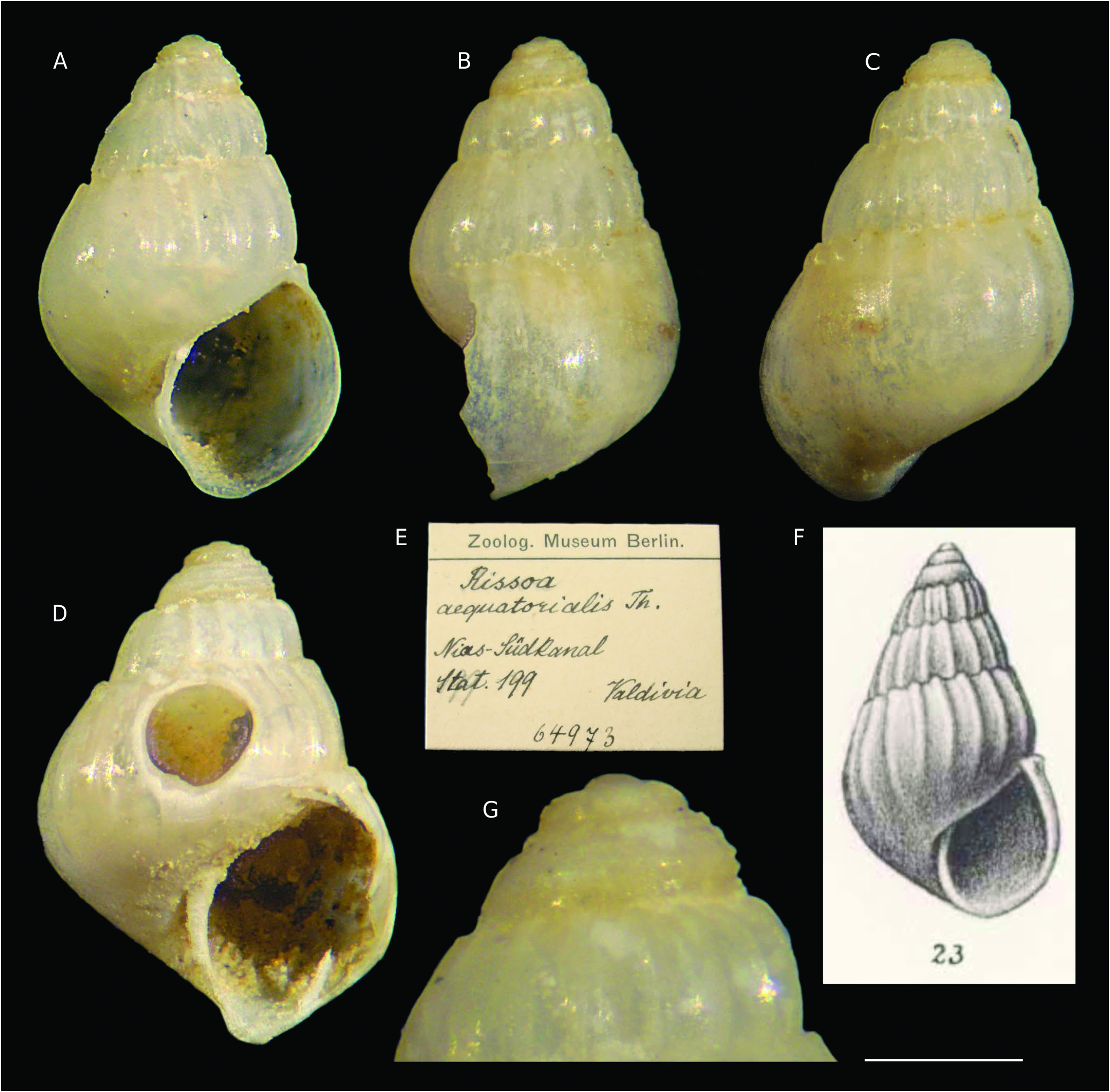
B. bouteti n. sp. differs from B. aequatorialis ( Thiele, 1925) n. comb. in its more robust tubercles at the subsutural crown; non-angled base (cfr juvenile shell of B. bouteti n. sp. in Fig. 14H View FIG with B. aequatorialis n. comb. in Fig. 11 View FIG A-D); higher protoconch 0.325 -0.375 mm and with five not equidistant spiral cordlets vs 0.275 with five equidistant cordlets in B. aequatorialis n. comb.
The juvenile specimen of an unidentified Benthonellania from southwestern Japan (Hasegawa: 152, fig. 5J) differs from juveniles of B. bouteti n. sp. in its more angled periphery, the weaker tubercled at the tips of axial ribs, and the faint spiral sculpture on the base (absent in Benthonellania bouteti n. sp.).
See under Benthonellania alis n. sp. for differences with this species.


No known copyright restrictions apply. See Agosti, D., Egloff, W., 2009. Taxonomic information exchange and copyright: the Plazi approach. BMC Research Notes 2009, 2:53 for further explanation.
|
Kingdom |
|
|
Phylum |
|
|
Class |
|
|
Order |
|
|
Family |
|
|
Genus |