
Benthonella communis, Amati & Giulio & Oliverio, 2022
|
publication ID |
https://doi.org/ 10.5252/zoosystema2022v44a12 |
|
publication LSID |
urn:lsid:zoobank.org:pub:ECBC345E-3870-4935-B430-744969F3DFD4 |
|
DOI |
https://doi.org/10.5281/zenodo.6798908 |
|
persistent identifier |
https://treatment.plazi.org/id/C42E14D5-7CED-4B62-BA1A-CAC05282C3E4 |
|
taxon LSID |
lsid:zoobank.org:act:C42E14D5-7CED-4B62-BA1A-CAC05282C3E4 |
|
treatment provided by |
Felipe |
|
scientific name |
Benthonella communis |
| status |
sp. nov. |
Benthonella communis View in CoL n. sp.
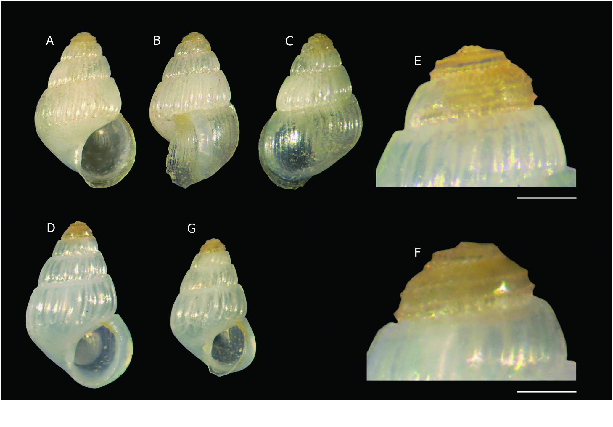
( Figs 4 View FIG A-G; 5H-J; 25C; 26C; Tables 1 View TABLE ; 2)
urn:lsid:zoobank.org:act:C42E14D5-7CED-4B62-BA1A-CAC05282C3E4
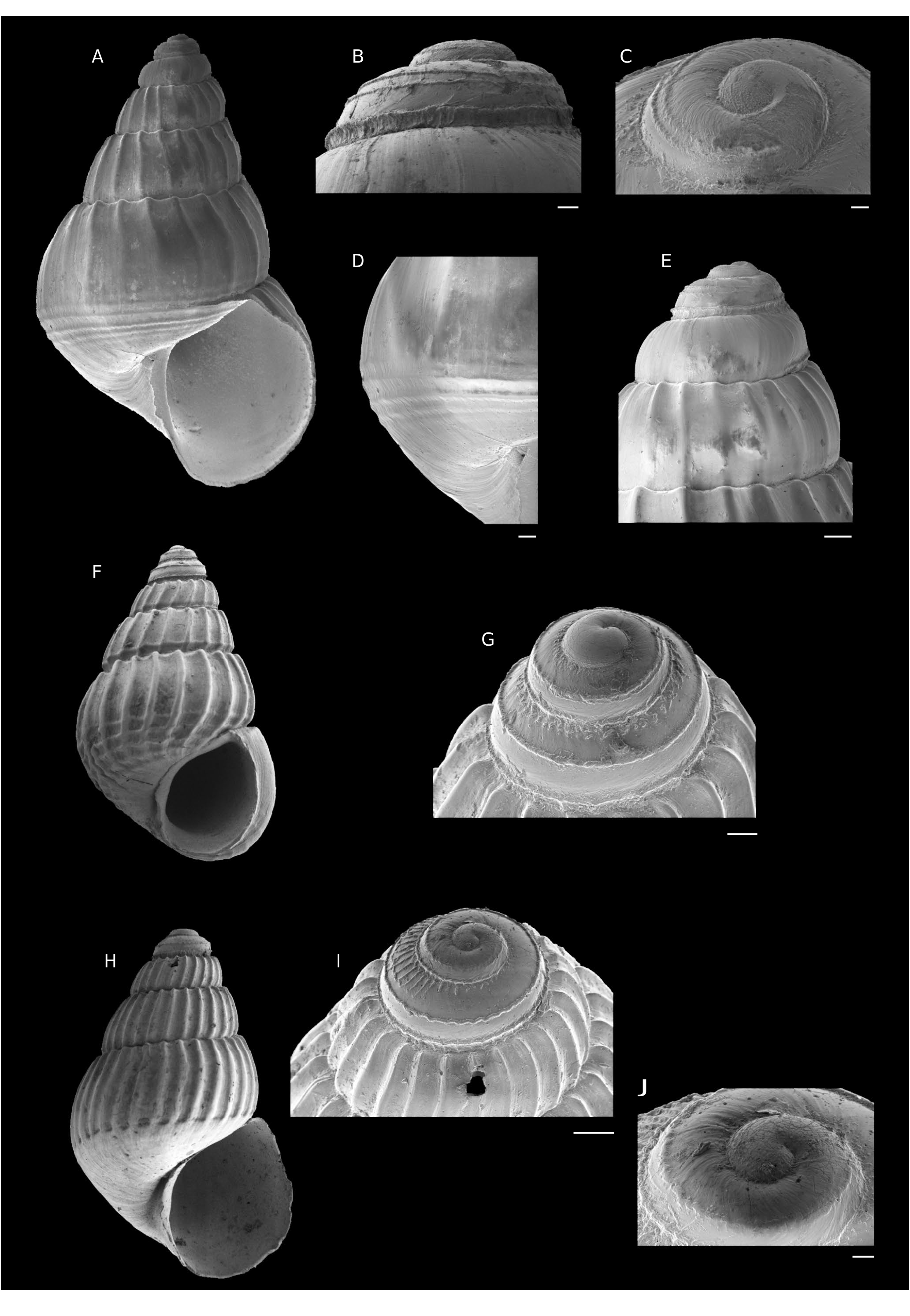
TYPE MATERIAL. — Holotype. Tarava Seamounts • dd (height 2.2 mm, width 1.45 mm, Figs 9 View FIG A-C; 10H-J); Mont Ari’i Moana , TARASOC Stn DW3309 ; 19°12’S, 151°35’W; 614-664 m depth; MNHN-IM-2000-37670 . GoogleMaps
Paratypes. Tarava Seamounts • 13 dd; same locality data as holotype; MNHN-IM-2000-37671 • 11 dd; Mont Ari’i Moana, TARASOC Stn DW3311; 19°12’S, 151°33’W; 24.IX.2009; 571-586 m depth; MNHN-IM-2000-37672 GoogleMaps • 50 dd; Mont Ari’i Moana, TARASOC Stn DW3319; 19°14’S, 151°32’W; 25.IX.2009; 480 m depth; MNHN-IM-2000-37673 GoogleMaps • 24 dd; Mont Ari’i Moana, TARASOC Stn DW3318; 19°15’S, 151°31’W; 25.IX.2009; 557-569 m depth; MNHN-IM-2000-37674 GoogleMaps • 6 dd; Mont Ari’i Moana, TARASOC Stn DW3321; 19°13’S, 151°32’W; 25.IX.2009; 540-572 m depth; MNHN-IM-2000-37675 GoogleMaps • 4 dd; Mont Ari’i Moana, TARASOC Stn DW3310; 19°13’S, 151°37’W; 24.IX.2009; 613-698 m depth; MNHN-IM-2000-37676 GoogleMaps • 126 dd; Mont Ari’i Moana, TARASOC Stn DW3316 519- 19°14’S, 151°33’W; 24.IX.2009; 520 m depth; MNHN-IM-2000-37677. GoogleMaps
TYPE LOCALITY. — Tarava Seamounts, Mont Ari’i Moana,TARASOC Stn DW3309; 19°12’S, 151°35’W; 614-664 m depth.
OTHER MATERIAL EXAMINED. — Society Islands • 22 dd; Maupiti, TARASOC Stn DW 3407; 16°32’S, 152°31’W; 12.X.2009; 445- 645 m depth; MNHN GoogleMaps • 5 dd; Moorea, TARASOC Stn DW 3481; 17°29’S, 149°45’W; 22.X.2009; 610 m depth; MNHN GoogleMaps • 20 dd; Tahiti, TARASOC Stn DW 3484; 17°47’S, 149°23’W; 23.X.2009; 300-650 m depth; MNHN GoogleMaps • 2 dd; Bora Bora, TARASOC Stn DW 3416; 16°35’S, 151°44’W; 13.X.2009; 914 m depth; MNHN GoogleMaps • 1 dd; Huahine, TARASOC Stn DW 3420; 16°46’S, 151°04’W; 14.X.2009; 550 m depth; MNHN GoogleMaps • 1 dd; Raiatea, TARASOC Stn DW 3451 16°53’S, 151°21’W; 18.X.2009; 440-490 m depth; MNHN. Tarava Seamounts GoogleMaps • 33 dd; Mont Punu Taipu, TARASOC Stn DW 3302; 19°15’S, 150°57’W; 23.IX.2009; 600-660 m depth; MNHN GoogleMaps • 2 dd; Mont Punu Taipu, TARASOC Stn DW 3300; 19°19’S, 151°00’W; 22.IX.2009; 670-757 m depth; MNHN. GoogleMaps
Tuamotu • 6 dd; SW Kaukura, TARASOC Stn DW3359; 15°57’S, 147°08’W; 1.X.2009; 462-980 m depth; MNHN GoogleMaps • 3 dd; Kaukura , TARASOC Stn DW 3373; 15°41’S, 146°54’W; 4.X.2009; 507-607 m depth; MNHN GoogleMaps • 4 dd; between Tikehau and Rangiroa ,TARASOC Stn DW 3349; 15°05’S, 148°03’W; 30.IX.2009; 976-997 m depth; MNHN. Australes GoogleMaps • 11 dd; Récif Neilson , BENTHAUS Stn DW 1924; 27°01’S, 146°05’W; 12.XI.2002; 340-800 m depth; MNHN GoogleMaps • 1 dd; Récif Neilson , BENTHAUS Stn DW 1925; 27°00’S, 146°05’W; 12.XI.2002; 560-790 m depth; MNHN GoogleMaps • 10 dd; Banc Mac Donald , BENTHAUS Stn DW 1875; 28°59’S, 140°15’W; 4.XI.2002; 110-150 m depth; MNHN GoogleMaps • 29 dd; Banc Président Thiers , BENTHAUS Stn DW 1933; 24°41’S, 146°01’W; 14.XI.2002; 500-850 m depth; MNHN GoogleMaps • 54 dd; Banc Président Thiers , BENTHAUS Stn DW 1932; 24°41’S, 146°02’W; 14.XI.2002; 500-800 m depth; MNHN GoogleMaps • 40 dd; Marotiri , BENTHAUS Stn DW 1885; 27°52’S, 143°33’W; 6.XI.2002; 700- 800 m depth; MNHN GoogleMaps • 3 dd; Rimatara , BENTHAUS Stn DW 2012; 22°38’S, 152°50’W; 25.XI.2002; 270-320 m depth; MNHN GoogleMaps • 188 dd, 1 lv; Banc Arago, BENTHAUS Stn DW 1979; 23°21.7’S, 150°43.9’W; 21.XI.2002; 176-340 m depth; MNHN GoogleMaps • 1 dd; Banc Arago, BENTHAUS Stn DW 1973; 23°23.5’S, 150°43.9’W; 20.XI.2002; 200-350 m depth; MNHN GoogleMaps • 2 dd; Banc Arago, BENTHAUS Stn DW 1974; depth 23°24’S, 150°44’W; 20.XI.2002; 450-618 m depth; MNHN GoogleMaps • 1 dd; Banc Arago, BENTHAUS Stn DW 1975; 23°24’S, 150°44’W; 20.XI.2002; 600-691 m depth; MNHN GoogleMaps • 29 dd; South coast of Rurutu , BENTHAUS Stn DW 2010; 22°32’S, 151°21’W; 24.XI.2002; 520-950 m depth; MNHN GoogleMaps • 1200+ dd; North coast of Rurutu , BENTHAUS Stn DW 1998; 22°25’S, 151°22’W; 23.XI.2002; 250-302 m depth; MNHN GoogleMaps • 6 dd; Marotiri , BENTHAUS Stn DW 1886; depth 27°51’S, 143°32’W; 6.XI.2002; 620-1000 mdepth; MNHN GoogleMaps • 8 dd; East coast of Rurutu , BENTHAUS Stn DW 2003; 22°27.6’S, 151°18.9’W; 24.XI.2002; 250-330 m depth; MNHN GoogleMaps • 9 dd; North coast of Raivavae , BENTHAUS Stn DW 1943; 23°49’S, 147°39’W; 24.XI.2002; 950 m depth; MNHN GoogleMaps • 8 dd; North of Raivavae , BENTHAUS Stn DW 1941; 23°49’S, 147°42’W; 15.XI.2002; 290-620 m depth; MNHN GoogleMaps • 7 dd; Marotiri , BENTHAUS Stn DW 1884; 27°54’S, 143°33’W; 6.XI.2002; 570-620 m depth; MNHN GoogleMaps • 50 dd; Tubuai , BENTHAUS Stn DW 1962; 23°21’S, 149°33’W; 19.XI.2002; 470-800 m depth; MNHN GoogleMaps • 17 dd; Tubuai , BENTHAUS Stn DW 1955; 23°19’S, 149°26’W; 18.XI.2002; 750-850 m depth; MNHN GoogleMaps • 69 dd; Tubuai , BENTHAUS Stn DW 1961; 23°21’S, 149°34’W; 19.XI.2002; 470-800 m depth; MNHN GoogleMaps • 1000+ dd; Banc Lotus , BENTHAUS Stn DW 1951; 23°49’S, 147°53’W; 17.XI.2002; 206-450 m depth; MNHN GoogleMaps • 118 dd; East of Rapa , BENTHAUS Stn DW 1889; 27°37’S, 144°16’W; 7.XI.2002; 600-620 m depth; MNHN GoogleMaps • 60 dd; Rimatara , BENTHAUS Stn DW 2021; 22°37’S, 152°49’W; 25.XI.2002; 1200-1226 m depth; MNHN GoogleMaps • 77 dd; Rimatara , BENTHAUS Stn DW 2020; 22°37’S, 152°49’W; 25.XI.2002; 920-930 m depth; MNHN GoogleMaps .
DISTRIBUTION AND SYMPATRY. — The species is at present known in the South Pacific Ocean from the Tarava Seamounts (Mont Ari’i Moana, Mont Punu Tipu), Society Islands (Maupiti, Moorea, Huahine, Tahiti, Bora Bora, Raiatea), Tuamotu (WS Kaukura, Kaukura, between Tikehau and Rangiroa) and Australes (Récif Neilson, Banc Mac Donald, Banc Président Thiers, Marotiri, Rimatara, Banc Arago, North coast of Rurutu, Tubuai, South coast of Rurutu, East coast of Rurutu, North coast of Raivavae, Banc Lotus, East coast of Rapa), with empty shells collected in 110-1226 m depth, and one live specimen collected at Australes, Banc Arago in 176-340 m depth ( Fig. 25C View FIG ). Benthonella communis n. sp. is sympatric with Benthonella boucheti n. sp. at the Australes (Récif Neilson, Banc Président Thiers, Marotiri, Rimatara, Banc Arago, Tubuai, South coast of Rurutu, East coast of Rurutu, North coast of Raivavae), Tuamotu (between Tichehau and Rangiroa); with Benthonella basistriata n. sp. at the Tuamotu (Kaukura), Society Islands (Huahine, Moorea); with Benthonellania maestratii n. sp. at the Australes (Récif Neilson, South coast of Rurutu); with Benthonellania bouteti n. sp. at the Tarava Seamounts (Mont Ari’i Moana, Mont Punu Tipu), Society Islands (Maupiti, Moorea, Huahine, Tahiti, Bora Bora, Raiatea), Tuamotu (WS Kaukura, Kaukura, entre Tichehau & Rangiroa), Australes (Récif Neilson, Banc Président Thiers, Rimatara, Banc Arago, North coast of Rurutu, South coast of Rurutu, East coast of Rurutu, Banc Lotus, East of Rapa, Tubuai); with Benthonellania tarava n. sp. at the Tarava Seamounts (Mont Ari’i Moana), Society Islands (Moorea), Tuamotu (WS Kaukura, Kaukura, between Tichehau and Rangiroa), Australes (Rimatara, South coast of Rurutu, East coast of Rimatara); with Benthonellania tuamotu n. sp. at the Tarava Seamounts (Mont Punu Tipu), Society Islands (Maupiti, Raiatea), Tuamotu (WS Kaukura, Kaukura, between Tikehau and Rangiroa), Australes (Rimatara, South coast of Rurutu, Récif Neilson); with Benthonellania megan n. sp. at the Australes (Rimatara); with Benthonellania alis n. sp. at the Tarava Seamounts (Mont Punu Taipu), Australes (East coast of Rurutu, South coast of Rurutu, Rimatara, Marotiri, Tubuai, Banc Président Thiers, East of Rapa), Society Islands (Bora Bora) ( Table 2).
ETYMOLOGY. — For the large number of specimens found, (Latin) communis – common.
DESCRIPTION OF HOLOTYPE.
Shell ( Figs 4 View FIG A-C; 5H-J)
Small for the genus, height 2.2 mm, width 1.45 mm, height/ width ratio 1.517, not very solid, ovate-conical.
Protoconch ( Figs 4E, F View FIG ; 5I, J View FIG ; Table 1 View TABLE )
Multispiral, dome-shaped, of 2.3 whorls, height 0.30 mm, nucleus diameter 0.05 mm, first half whorl diameter 0.112 mm, maximum diameter 0.425 mm; protoconch I with sparse microtubercles and traces of spiral threads (embryonic shell in poor condition) ( Fig. 5J View FIG ), protoconch II with two fine and slightly wavy spiral cordlets, and a series of axial L-shaped subsutural rodlets between abapical cordlet and suture on the last half protoconch whorl ( Fig. 5I View FIG ). Protoconch-teleoconch boundary indistinct, sinuous.
Teleoconch
Of 3.25 slightly convex whorls, suture canaliculate, crowned by small tubercles on tip of axial ribs. Height last whorl 1.575 mm. height/height last whorl ratio 1.396. Axial sculpture of 27 flexuose, opisthocline ribs on last whorl, as broad as the interspaces, abruptly interrupted before the base. Spiral sculpture absent.Microsculpture of only growth striae ( Fig. 5I View FIG ). Umbilical chink present. Aperture pyriform, small, height 1.0 mm, height/height aperture ratio 2.200, peristome continuous, varix weak; outer lip opisthocline, sharp, internally smooth. Columella arcuate simple.
Colour
Coloration of teleoconch white, outer lip pale orange, slightly darker adapically, protoconch pale whitish-orange.
Operculum and soft parts
Unknown.
VARIABILITY
Species not very variable (see Table 1 View TABLE and Appendix 3). Minimum height 1.27 (from North coast of Rurutu, 250- 302 m); maximum height 2.40 (from Mont Ari’i Moana, 614-664 m). Variable number of axial ribs: 16-27. In about 10% of specimens examined, the external lip presents a more or less conspicuous angulation ( Fig. 4G View FIG ). The axial ribs are thinner when they are more numerous.
REMARKS
The axial ribs abruptly stopping before the base (around the maximum diameter of the whorl), generate a sort of false spiral cord.
Benthonella olangoensis from the Philippines, is very similar to Benthonella communis n. sp. in the general shape, but is distinguished by the presence of 2-3 spiral cordlets vs absent in B. communis n. sp.
Benthonella brontodes Lozouet, 1990 , from the upper Oligocene of the Aquitaine basin ( France), is very similar to B. communis n. sp., but differs mainly in its different protoconch, narrower and lower (height 151 µm and maximum diameter 379 µm vs height 0.275 -0.325 mm and maximum diameter 0.400 - 0.437 mm in B. communis n. sp.), and with different sculpture: with a fine median cordlet, doubled in the first half whorl vs two fine and slightly wavy spiral cordlets, and a series of axial L-shaped subsutural rodlets between abapical cordlet and suture on the last half protoconch whorl ( Fig. 10I View FIG ) in B. communis n. sp. (see Lozouet 1990: 325, figs 24-25).


| MNHN |
Museum National d'Histoire Naturelle |
No known copyright restrictions apply. See Agosti, D., Egloff, W., 2009. Taxonomic information exchange and copyright: the Plazi approach. BMC Research Notes 2009, 2:53 for further explanation.
|
Kingdom |
|
|
Phylum |
|
|
Class |
|
|
Order |
|
|
Family |
|
|
Genus |