
Benthonella boucheti, Amati & Giulio & Oliverio, 2022
|
publication ID |
https://doi.org/ 10.5252/zoosystema2022v44a12 |
|
publication LSID |
urn:lsid:zoobank.org:pub:ECBC345E-3870-4935-B430-744969F3DFD4 |
|
DOI |
https://doi.org/10.5281/zenodo.6798902 |
|
persistent identifier |
https://treatment.plazi.org/id/20D288CF-46E8-4160-B602-22886ADDFE4C |
|
taxon LSID |
lsid:zoobank.org:act:20D288CF-46E8-4160-B602-22886ADDFE4C |
|
treatment provided by |
Felipe |
|
scientific name |
Benthonella boucheti |
| status |
sp. nov. |
Benthonella boucheti View in CoL n. sp.
( Figs 2 View FIG A-G; 5A-E; 25A; 26A; Tables 1 View TABLE ; 2)
urn:lsid:zoobank.org:act:20D288CF-46E8-4160-B602-22886ADDFE4C
TYPE MATERIAL. — Holotype. Tarava Seamounts • dd (height 4.32 mm, width 2.75 mm, Figs 6A View FIG ; 7 View FIG A-C); Mont Honu , TARASOC Stn DW3340 ; 18°24’S, 154°09’W; 787-798 m; MNHN- IM-2000-37666 . GoogleMaps
Paratypes • 22 dd; same locality data as holotype; MNHN- IM-2000-37667 .
TYPE LOCALITY. — Tarava Seamounts, Mont Honu, TARASOC Stn DW3340, 18°24’S, 154°09’W, 787- 798 m.
OTHER MATERIAL EXAMINED. — Tarava Seamounts • 2 dd; Mont ‘ Otaha, TARASOC Stn DW 3333; 18°45’S, 152°18’W; 795-975 m; 26.IX.2009; MNHN GoogleMaps • 3 dd; Mont ‘ Otaha,TARASOC Stn DW 3328; 18°46’S, 152°15’W; 788-836 m; 26.IX.2009; MNHN GoogleMaps • 1 dd; Mont ‘ Otaha, TARASOC Stn DW 3331; 18°45’S, 152°17’W; 766 m; 26.IX.2009; MNHN. GoogleMaps
Marquesas • 2 dd; Fatu Hiva, MUSORSTOM 9 Stn DR 1247; 10°34’S, 138°42’W; 1150-1250 m; 1.IX.1997; MNHN GoogleMaps .
Australes • 9 dd; Banc Président Thiers , BENTHAUS Stn DW 1933; 24°41’S, 146°01’W; 500-850 m; 14.XI.2002; MNHN GoogleMaps • 2 dd; Récif Neilson , BENTHAUS Stn DW 1925; 27°00’S, 146°05’W; 560- 790 m; 12.XI.2002; MNHN GoogleMaps • 15 dd; Récif Neilson , BENTHAUS Stn DW 1925; 27°00’S, 146°05’W; 560-790 m; 12.XI.2002; MNHN GoogleMaps • 21 dd; South coast of Rurutu , BENTHAUS Stn DW2010 ; 22°32’S, 151°21’; 520-950 m; 24.XI.2002; MNHN GoogleMaps • 1 dd; Tubuai , BENTHAUS Stn DW 1961; 23°21’S, 149°34’; 470-800 m; 19.XI.2002; MNHN GoogleMaps • 4 dd; Tubuai , BENTHAUS Stn DW 1955; 23°19’S, 149°26’W; 750-850 m; 18.XI.2002; MNHN GoogleMaps • 6 dd; Tubuai , BENTHAUS Stn DW 1956; 23°18’S, 149°27’W; 600-990 m; 18.XI.2002; MNHN GoogleMaps • 1 dd; Tubuai , BENTHAUS Stn DW 1962; 23°21’S, 149°33’W; 470-800 m; 19.XI.2002; MNHN GoogleMaps • 3 dd; North of Raivavae , BENTHAUS Stn DW 1943; 23°49’S, 147°39’W; 950 m; 15.XI.2002; MNHN GoogleMaps • 3 dd; Marotiri , BENTHAUS Stn DW 1886; 27°51’S, 143°32’W; 620-1000 m; 6.XI.2002; MNHN GoogleMaps • 2 dd; Marotiri , BENTHAUS Stn DW 1887; 27°52’S, 143°33’W; 750-1000 m; 6.XI.2002; MNHN GoogleMaps • 9 dd; Banc Arago, BENTHAUS Stn DW 1981; 23°21’S, 150°43’W; 650-1150 m; 21.XI.2002; MNHN GoogleMaps • 15 dd; Rimatara , BENTHAUS Stn DW 2021; 22°37’S, 152°49’W; 1200-1226 m; 25.XI.2002; MNHN GoogleMaps • 9 dd; Rimatara , BENTHAUS Stn DW 2020; 22°37’S, 152°49’W; 920-930 m; 25.XI.2002; MNHN GoogleMaps • 9 dd; East coast of Rurutu, BENTHAUS Stn DW 2004; 22°28’S, 151°19’W; 430-850 m; 24.XI.2002. GoogleMaps
Tuamotu • 1 dd; between Tikehau and Rangiroa, TARASOC Stn DW 3349; 15°05’S, 148°03’W; 976-997 m; 30.IX.2009; MNHN GoogleMaps .
DISTRIBUTION AND SYMPATRY. — Benthonella boucheti n. sp. is known from the South Pacific Ocean, in the Tarava Seamounts (Mont Honu, Mont ‘Otaha), Australes (Banc Président Thiers, Récif Neilson, South Coasts of Rurutu, East coasts of Rurutu, Tubuai, North of Raivavae, Marotiri, Banc Arago, Rimatara), Marquesas (Ile Fatu Hiva), Tuamotu (between Tikehau and Rangiroa), with empty shells collected in 430-1250 m depth ( Fig. 25A View FIG ).
Benthonella boucheti n. sp. is sympatric with Benthonellania maestratii n. sp. at the Australes (Récif Neilson, South coast of Rurutu); with Benthonella communis n. sp. at the Australes (Banc Président Thiers, Récif Neilson, South Coasts of Rurutu, East coasts of Rurutu, Tubuai, North of Raivavae, Marotiri, Banc Arago, Rimatara), Tuamotu (between Tikehau and Rangiroa); with Benthonellania bouteti n. sp. at the Tarava Seamounts (Mont Honu and Mont ‘Otaha), Australes (Banc Président Thiers, Récif Neilson, South Coasts of Rurutu, East coasts of Rurutu, Banc Arago, Rimatara. Tubuai), Tuamotu (between Tikehau and Rangiroa); with Benthonellania tarava n. sp. at the Tarava Seamounts (Mont Honu and Mont ‘Otaha), Australes (Rimatara, South coast of Rurutu, East coast of Rurutu), Tuamotu (between Tikehau and Rangiroa); with Benthonellania tuamotu n. sp. at the Tarava Seamounts (Mont ‘Otaha), Australes (Rimatara, South coast of Rurutu, Récif Neilson), Tuamotu (between Tikehau and Rangiroa); with Benthonellania lozoueti n. sp. at the Marquesas (Ile Fatu Hiva); with Benthonellania megan n. sp. at the Marquesas (Ile Fatu Hiva), Australes (Rimatara); with Benthonellania alis n. sp. at the Australes (East coast of Rurutu, South coast of Rurutu, Rimatara, Marotiri, Tubuai, Banc Président Thiers), Tarava Seamounts (Mont ‘Otaha, Mont Honu) ( Table 2).
ETYMOLOGY. — Named after Philippe Bouchet (MNHN), for his indefatigable work during decades, aimed at improving the knowledge of marine biodiversity.
DESCRIPTION OF HOLOTYPE.
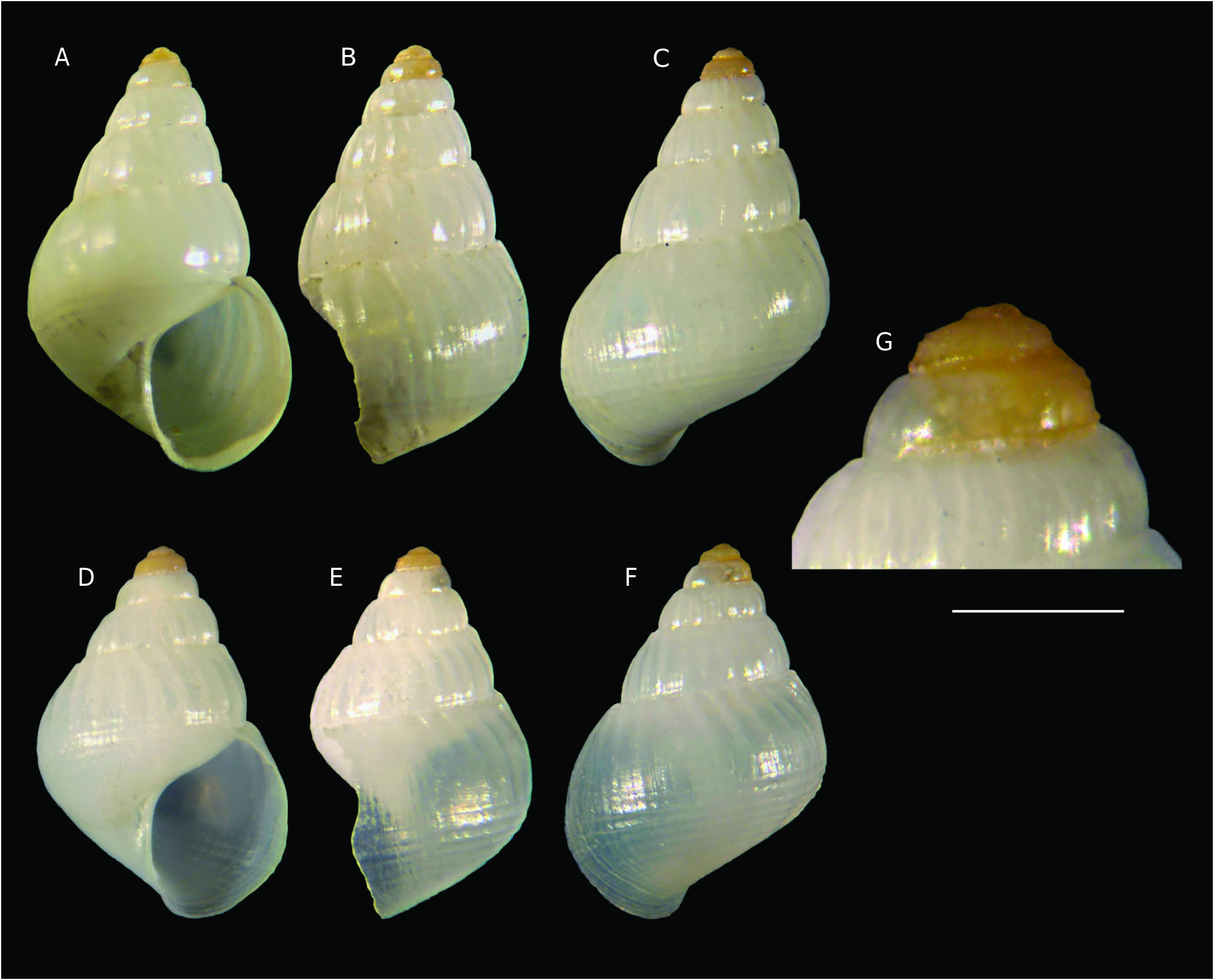
Shell ( Figs 2 View FIG A-C; 5A-E)
Large for the genus, height 4.3 mm, width 2.7 mm, height/width ratio 1.57, ovate-conical, rather fragile, with broad last whorl.
Protoconch ( Figs 2G View FIG ; 5B, C, E View FIG )
Multispiral, dome-shaped, of 2.4 whorls, height 0.4125 mm, nucleus diameter 0.075 mm, first half whorl diameter 0.1375 mm, maximum diameter 0.60 mm; protoconch I with 4 threads, interspaces covered by microtubercles ( Fig.5C View FIG ); protoconch II with two pairs of spiral cordlets, and closely set axial micro-riblets in the interspace of the abapical pair ( Fig. 5B View FIG ). Protoconch-teleoconch, boundary indistinct, sinuous.
Teleoconch
Of 4.2 slightly convex whorls of slowly increasing height; suture incised, slightly canaliculate and wavy. Height last whorl 2.9 mm, height/height last whorl ratio 1.491. Axial sculpture of weak, flat, curved and prosocline ribs, half as broad as the interspaces, absent on the first half whorl, 20 on the last whorl, gradually vanishing at the base, prominent at suture, giving the whorls a coronated appearance ( Fig. 5E View FIG ). Spiral sculpture of 7 weak, narrow and very low, indistinct spiral cordlets, only on the base. Microsculpture of only growth striae ( Fig. 5D View FIG ). Umbilical chink present. Aperture pyriform, large, height 2.0 mm, height/height aperture ratio 2.162, peristome continuous, outer lip prosocline (broken), internally smooth. Columella arcuate, simple.
Colour
Coloration of teleoconch white, protoconch orange.
Operculum and soft parts
Unknown.
VARIABILITY
Only two full-grown intact specimens available; the variability seems low (see Table 1 View TABLE and Appendix 1).
REMARKS
Benthonella boucheti n. sp. resembles the northeastern Atlantic and Mediterranean Benthonella tenella ( Jeffreys 1869: 204, pl. CI, fig. 7) for the conical outline with a broad last whorl, especially in the so-called ‘form fischeri Dall, 1889 ’ ( Ponder 1985: 63, figs 39A, B; Bouchet & Warén 1993: 699, figs 1643-1650; Lozouet 2014: 24, 31, figs 2R, S, and 7A-C), with its axial sculpture on the first teleoconch whorls (absent in the typical form). Benthonella boucheti n. sp. differs in its less rounded aperture, spiral sculpture on the base, and different apical sculpture: protoconch II with two pairs of spiral cordlets, in the interspaces of the abapical pair, confused and close axial micro riblets vs protoconch II with two thin spiral cordlets and a subsutural belt of microgranules in B. tenella .

No known copyright restrictions apply. See Agosti, D., Egloff, W., 2009. Taxonomic information exchange and copyright: the Plazi approach. BMC Research Notes 2009, 2:53 for further explanation.
|
Kingdom |
|
|
Phylum |
|
|
Class |
|
|
Order |
|
|
Family |
|
|
Genus |