
Xylopia humblotiana Baill.
|
publication ID |
https://doi.org/ 10.5252/adansonia2020v42a1 |
|
persistent identifier |
https://treatment.plazi.org/id/417D87A4-FFE4-FFF1-FC11-56CE3157FCF3 |
|
treatment provided by |
Tatiana |
|
scientific name |
Xylopia humblotiana Baill. |
| status |
|
4. Xylopia humblotiana Baill. View in CoL
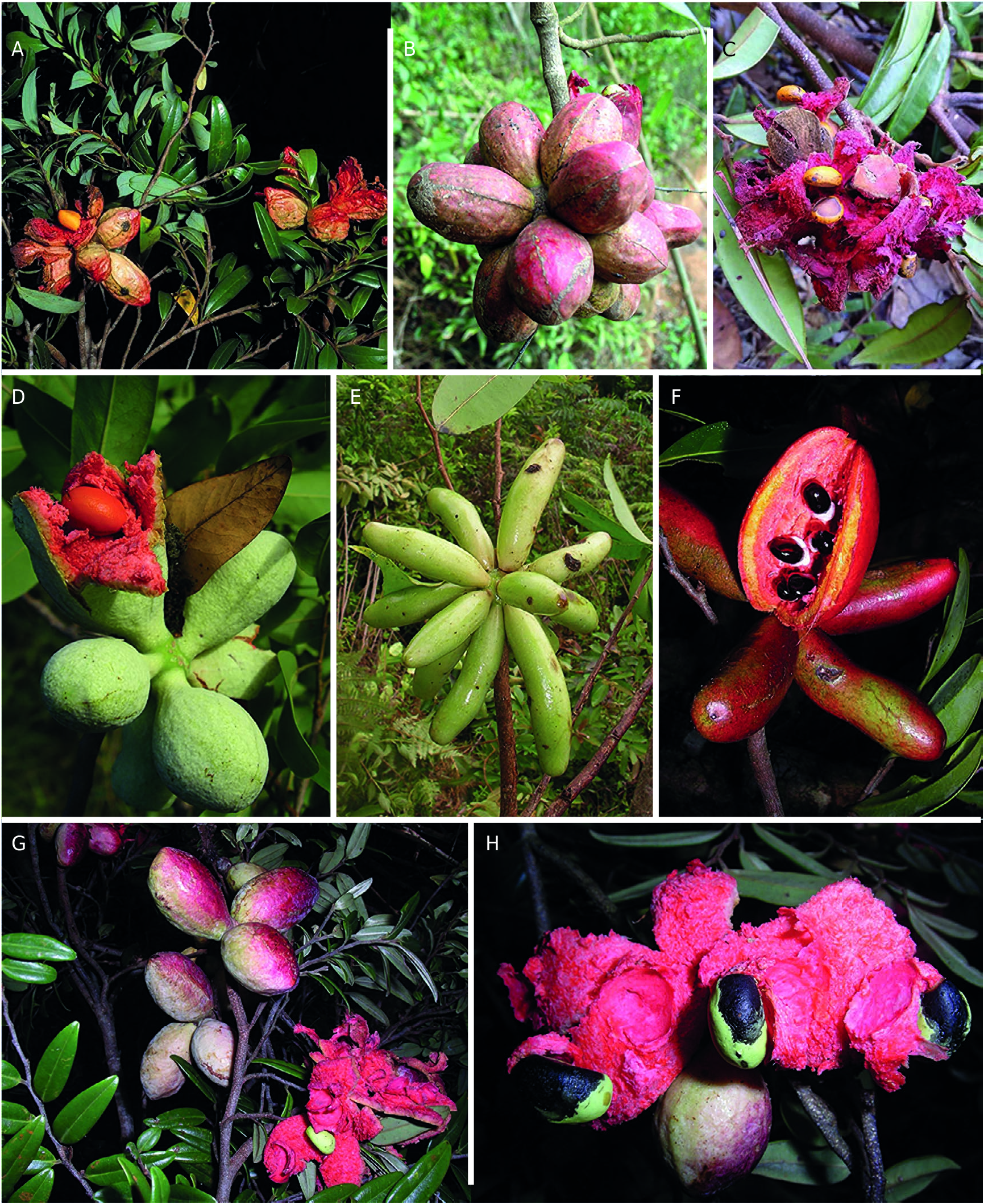
( Figs 1A View FIG ; 2C, F View FIG ; 9G-M View FIG )
Bulletin mensuel de la Société linnéenne de Paris 1: 340 (1882). — Type: Madagascar. Prov. Toamasina, ad lacum Nossibé , IV.1882 (fl., fr.), Humblot 117 (holo-, P[P030398]!; iso-, K[K000199050]!, P[P030399]!) .
Xylopia platynema Diels, Notizblatt des Botanischen Gartens und Museums zu Berlin-Dahlem 9: 351 (1925). View in CoL — Type: Madagascar. Prov. Toamasina [ “Madagascaria orientalis” ], forêt littorale orientale pres d’Ambilo , II.1924 (fl., fr.), Perrier de la Bâthie 15998 (holo-, P [ P00524382 ]!, iso-, P[P00608328]!).
MATERIAL EXAMINED. — Madagascar. Prov. Antsiranana. Parc national de Masoala, Andranomaintiny, Fok. Sahamalaza, Fir. Vinanivao, 15°49’S, 50°18’E, 0-41 m, 21.II.1996 (fl.), Aridy & MoÏse 168 ( MO); sur la piste de Beankoraka vers Vinanivao , Firaisana Vinanivao, Masoala, 15°57’S, 50°12’E, 10-60 m, 17.XI.1994 (fr.), Rabe 154 ( MO) GoogleMaps ; forêt littorale Ambodiletry, Beankoraka, Parc national de Masoala, 15°59’17”S, 50°13’00”E, 0 m, 12.XI.1994 (fr.), Rahajasoa et al. 844 ( MO) GoogleMaps ; Sava Region , forêt d’Antsoha , Fokontany Sahafary , Firaisana Ambohitralanana, Fivondronana Antalaha, 15°16’12”S, 50°23’14”E, 50 m, 1.X.1997 (fl.), Ravololonanahary 110 ( OWU) GoogleMaps ; 5.8 km S of Lokoho River along coastal road between Sambava and Antalaha, 6.8 km S of Farahanana, 14°29’S, 50°10’E, 50 m, 15.X.1988 (fl., fr.), Schatz 2381 (K n.v., MO) GoogleMaps ; Masoala National Park , 2 km W of Camp Est, 15°16’23”E, 50°27’24”E, 5 m, 23.I.1999 (bud, fr.), Schatz et al. 3776 ( MO) .
Prov. Fianarantsoa. Route Farafangana-Vangaindrano, XII.1963 (fl.), Bosser 18678 (K n.v., MO); Fiv. Nosy Varika , Fir. Ambahy, littoral forest on sand of Ambahy, 20°46’20”S, 48°28’39”E, 13 m, 7.XII.2002 (fl.), Koopman et al. 135 ( OWU) GoogleMaps ; Vatovavy Fitovinany , Manakara , Andosy, Lohokola Forest, 21°43’38”S, 48°11’19”E, 22 m, 28.I.2009 (fr.), Letsara et al. LRK 824 ( CAS) GoogleMaps ; Farafangana , Mahabo Mananivo, Nosiala, 23°11’10”S, 47°43’02”E, 30 m, 5.VIII.2004 (immature fr.), Ludovic et al. 883 ( MO) GoogleMaps ; Préfecture Farafangana , Commune rurale Mahabo Mananivo, Fokontany Mahabo, 23°11’19”S, 47°41’16”E, 12 m, 28.IX.2004 (immature fr.), Ludovic et al. 914 ( MO) GoogleMaps ; S of Farafangana, near village of Mahabo , 23°10’36”S, 47°42’01”E, 3.XI.2001 (fr.), McPherson & Rabenantoandro 18316 (K n.v., MO) GoogleMaps ; Fivondronana Nosy Varika , Firaisana Ambahy , Rokontany Ambahy, forêt d’Andohan’I Martin, 20°48’07”S, 48°38’56”E, 9 m, 15.II.2004 (fl., fr.), Rabehevitra et al. 871 ( MO, P[P02090396]) GoogleMaps ; Fivondronana : Farafangana , Fokontany : Manombo, forêt littorale sur sable de Manombo, 23°04’13”S, 47°45’45”E, 20 m, 12.XI.2001 (fl.), Rabenantoandro et al. 747 ( MO) GoogleMaps ; Fokontany Mahabo , commune rurale Mahabo-Mananivo, Fivondronana Farafangana, 23°10’12”S, 47°41’54”E, 5.II. 2001 (fr.), Rabevohitra & Rabenantoandro 3792 ( MO) GoogleMaps ; Fokontany Mahabo , commune rurale Mahabo-Mananivo, Fivondronana Farafangana, 23°10’12”S, 47°41’54”E, 5.II.2001 (fl., fr.), Rabevohitra & Rabenantoandro 3793 ( MO) GoogleMaps ; Fivondronana , Nosy Varika , Firaisana et Fokontany: Ambahy, 20°46’15”S, 48°28’48”E, 21.III.2003 (fl.), Rabevohitra et al. 4608 (K n.v., MO, NY) GoogleMaps ; Fivondronana , Nosy Varika , Firaisana et Fokontany: Ambahy, 20°46’15”S, 48°28’48”E, 21.III.2003 (fr.), Rabevohitra et al. 4635 ( MO) GoogleMaps ; Fivondronana : Nosy Varika , Commune rurale: Ambahy , Fokontany : Ambahy , forêt d’Ambahy à 500 m à l’Est du Fokontany, 20°46’57”S, 48°28’54”E, 17.XI.2003 (fl.), Rabevohitra et al. 4789 (K n.v., NY) GoogleMaps ; Fivondronana : Mahanoro , Firaisana : Ambodibonara , Fokontany : Ambalavontaka, forêt de Nankinana, 20°22’22”S, 48°33’56”E, 13 m, 17.IV.2004 (fl.), Ranaivojaona et al. 618 ( MO, OWU) GoogleMaps ; Fivondronana Mananjary , Firaisana Ankatafana, Fokontany Marohita, 21°28’29”S, 48°16’51”E, 13 m, 3.X.2004 (immature fr.), Ranaivojaona et al. 924 (K n v., MO) GoogleMaps ; Farafangana , Mahabo-Mananivo, Mahabo, 23°11’13”S, 47°42’27”E, 22 m, 26.VIII.2003 (immature fr.), Razakamalala & Rabehevitra 700 ( MO) GoogleMaps ; Fivondronana : Mahanoro , Commune rurale: Ambodibonara , Fokontany : Ambalavontaka, forêt littorale sur sables de Nakinà, 20°21’06”S, 48°36’48”E, 41 m, 8.XI.2003 (fr.), Razakamalala et al. 838 ( MO, OWU) GoogleMaps ; Fivondronana , Nosy Varika , Firaisana : Ambahy , Fokontany : Ambahy, forêt d’Ambahy, 20°47’49”S, 48°28’58”E, 10 m, 23.IV.2004 (fl.), Razakamalala et al. 1175 ( MO, OWU, P[P06901350]) GoogleMaps .
Prov. Toamasina. Près Fénérive, XI.1906 (fl., immature fr.), d’Alleizette s. n. (L); Station forestière de Tampolo , Fénérive-Est, Parcelle A1, 17°17’00”S, 49°23’30”E, 10 m, 3.X.2004 (fr.), Andriambololonera & Lehavana 25 ( OWU, P[P00909322]) GoogleMaps ; Fivondronana Sainte Marie , Firaisana Lokintsy, Fokontany Sahasifotra, 16°51’09”S, 49°57’13”E, 19 m, 9.X.2003 (immature fr.), Andrianarivelo et al. 88 ( MO) GoogleMaps ; Tamatave , III.1891 (fl.), Baron 5997 (K) ; Toamasina , 0-2 km E of Andavakimenarana (location of ferry to cross Pangalanes on road to Brickaville-Ambila), Tamatave, 18°52’34”S, 49°08’12”E, 1-10 m, 14-16.II.1999 (fl.), Birkinshaw et al. 560 (K n.v., MO) GoogleMaps ; Est : forêt sublittorale, à Tampolo, au Nord de Fénérive, 9.III.1965 (fl.), Capuron 24044 SF (K n.v., BR) ; Tamatave , Ankarefo (canal des Pangalanes), 14.XII.1966 (bud, immature fr.), Capuron SF 26227 (K n.v., OWU) ; Prov. Tamatave , along Route #5 between Tamatave and Fenerive at World Wildlife Fund Aye-Aye Preserve, near PK 83, more than 50 m, 27.II.1975 (fr.), Croat 32529 ( MO) ; E coast of Madagascar, Ambila-Lemaitso , c. 103 km S of Toamasina, 18°51’S, 49°08’E, 21.XI.1997 (fr.), Davis 1121 (G, K n.v., MO) GoogleMaps ; Prov. Tamatave , Station Forestière de Tampolo, 10 km N of Fenerive, 29.XI.1985 (fr.), Dorr et al. 4397 (K n.v., MO, PRE, WAG) ; Prov. Tamatave , south side of ferry-crossing on road from Brickaville to Ambila Lemaitso, 11.XII.1985 (fr.), Dorr et al. 4479 (K n. v., MO, PRE) ; Prov. Tamatave , Ambila-Lemaitso , second lake S of road-junction for Andevoranto and Brickaville, 20.I.1986 (fr.), Dorr et al. 4593 (K n.v., MO, PRE) ; along coast at Ambila-Lemaitso , 18°49’S, 49°09’E, 15.XI.1989 (fr.), Keating & Miller 2255 (K n.v., MO) GoogleMaps ; Ambila-Lemaitso , E of Brickaville, Old Station Forestière, c. 5 km S of town, 18°54’S, 49°07’E, 10 m, 17.I.1999 (fl., fr.), Lowry & Miller 5138A ( MO) GoogleMaps ; Vohibola , forest N of Pangalane Hotel, N shore of Lac Ampitabe, c. 2 km W of Andranokoditra, 18°35’46”S, 49°14’06”E, 2-5 m, 9.II.2003 (fr.), Lowry et al. 6030 ( MO, OWU) GoogleMaps ; Vohibola , forest N to NNW of village of Andranokoditra, N of Lac Ampitabe, 18°33’34”S, 49°15’01”E, 5 m, 12.II.2003 (fl.), Lowry et al. 6090 (K n.v., MO, OWU) GoogleMaps ; Préfecture Mahanoro, S. P. Masomeloka , Comm. Ambodibonara, Fok. Ambalavontaka, 20°21’44”S, 48°37’05”E, 23 m, 11.II.2004 (fr.), Ludovic & Rabehevit [r] a 552 ( MO) GoogleMaps ; Toamasina , Ile Sainte-Marie , Lokintsy, forêt d’Ambohidena, 16°51’11”S, 49°57’10”E, 10 m, 13.V.2003 (fr.), McPherson et al. 18900 ( MO) GoogleMaps ; Analanjirofo Region , Pointe ṙ Larree , District de Soanierana-Ivongo , la commune Antanifotsy, Fokontany Manjato, 16°46’06”S, 49°42’38”E, XI.2008 (fr.), Nikolov 1774 ( MO, P[P00982779, P01061922]) GoogleMaps ; Brickaville District , Hotel Pangalan on Lake Ampitabe, W of Andranokoditra, 18°35’S, 49°14’E, 9.I.2003 (fr.), Pell et al. 617 ( MO, NY) GoogleMaps ; Maroantsetra , Tampolo, Péninsule Masoala, 15°43’S, 49°57’E, 20-50 m, 5.XI.2001 (fl.), Poncy et al. 1594 ( MO) GoogleMaps ; Maroantsetra , Tampolo, Péninsule Masoala, 15°43’S, 49°57’E, 0-10 m, 5.XI.2001 (fr.), Poncy et al. 1597 (K n.v., MO) GoogleMaps ; Fivondronana : Sainte Marie , Firaisana : Lokintsy , Fokontany : Ambohidena, forêt littorale sur sable non consolidé d’Ambohidena, 16°51’11”S, 49°57’10”E, 1.VI.2004 (fl.), Rabehevitra & Poity 1205 ( MO, OWU, P[P01954138]) GoogleMaps ; Fivondronana : Soanierana Ivongo , Firaisana : Manompana , Fokontany : Antanambaon ‘ Ambodimanga, forêt d’Andakibe, 16°47’01”S, 49°44’23”E, 3 m, 4.X.2003 (fr.), Rabehevitra et al. 579 ( MO, OWU, P[P01986989]) GoogleMaps ; Fivondronana : Mahanoro , Firaisana : Ambodibonara , Fokontany : Ambalavontaka, forêt de Nankinana, 20°21’15”S, 48°36’26”E, 18 m, 10.II.2004 (fl.), Rabehevitra et al. 782 ( MO, OWU, P[P06901351]) GoogleMaps ; Fivondronana : Mahanoro , Firaisana : Ambodibonara , Fokontany : Ambalavontaka, forêt de Antaimby, 20°22’21”S, 48°33’15”E, 16 m, 12.II.2004 (fl.), Rabehevitra et al. 825 ( MO, OWU, P[P06901352]) GoogleMaps ; Fivondronana , Soanierana-Ivongo , Commune Rurale : Manompana, forêt d’Antanambao-Ambodimanga, 16°46’24”S, 49°42’51”E, 30.I.2003 (fl., fr.), Rabevohitra et al. 4306 ( MO, NY) GoogleMaps ; Fivondronana Soanierana-Ivongo , village d’Andrangazaha, Bureau Dette Nature Andrangazaha, 16°52’02”S, 49°40’52”E, 29.I.2004 (buds), Rabevohitra & Rakotomamonjy 4874 ( MO) GoogleMaps ; Fivondronana : Sainte Marie , Firaisana : Lokintsy , Fokontany : Ambohidena, forêt d’Ambohidena, 16°51’11”S, 49°57’18”E, 8.II.2004 (fr.), Rabevohitra et al. 4986 ( MO, OWU) GoogleMaps ; Toamasina , Parc national de Masoala, Antalavia, 15°47’00”S, 50°02’00”E, 0 m, 27.XI.1994 (st.), Rahajasoa et al. 1066 ( MO) GoogleMaps ; District Fenerive-Est , Station forestière de Tampolo, 10 km Nord de Fenerive-Est, 17°16’52”S, 49°24’44”E, 0-150 m, 24.I.1995 (fr.), Raholivelo et al. 251 ( MO) GoogleMaps ; Brickaville , Ambinaninony , Andranokoditra, Vohibola, 18°33’35”S, 49°15’05”E, 0-10 m, 26.X.2002 (fr.), Ranaivojaona et al. 448 (K n.v., MO) GoogleMaps ; Fivondronana : Mahanoro , Firaisana : Ambodibonara , Fokontany : Ambalavontaka , forêt de littoral d’Ampanamara (Antaimby Kely), 20°22’48”S, 48°33’23”E, 13 m, 12.VI.2004 (fr.), Ranaivojaona et al. 755 ( MO, OWU) GoogleMaps ; Fivondronana : Mahanoro , Firaisana : Ambodibonara , Fokontany : Ambalavontaka , forêt de littorale d’Analamalotra (Antaimby Kely), 20°22’57”S, 48°33’13”E, 13 m, 28.IX.2004 (fr.), Ranaivojaona et al. 843 ( MO, OWU, P[P01954137]) GoogleMaps ; Fivondronana Mahanoro , Firaisana Ambodibonara , Fokontany Ambalavontaka, forêt littorale de Nankinana, 20°21’30”S, 48°36’50”E, 8 m, 30.IX.2004 (immature fr.), Ranaivojaona et al. 893 ( MO, P[P00982781]) GoogleMaps ; Fivondronana Brickaville , S of Ambila, 18°54’S, 49°07’E, 0-10 m, 4.VIII.1996 (fl., immature fr.), Randrianasolo 478 ( MO) GoogleMaps ; Analanjirofo Region , Fivondronana : Fénérive-Est , Fokontany Ambodimanga, Tampolo, 17°17’05”S, 49°23’16”E, 0-10 m, 13.I.2001 (fr.), Razafitsalama 101 (K n.v., MO, P[P00903556]) GoogleMaps ; Analanjirofo Region , Commune Manompana, Fokontany Antanambao-Ambodimanga, 16°48’07”S, 49°44’32”E, 6-16 m, 22-29.IX.2010 (fr.), Razanatsoa et al. 523 ( MO) GoogleMaps ; Andevoranto-Ambila Lemaitso Road , c. 3-6 km NNE of Andevoranto, 18°53’50”S, 49°07’40”E, 30 m, 2.II.2006 (fl.), Rogers & Antilahimena 1007 ( MO [2 sheets], OWU, P[P02005890]) GoogleMaps ; Prov. Toamasina , 6-10 km S of Ambila-Lemaitso, 18°51’S, 49°08’E, 0-20 m, 6.III.1988 (fl.), Schatz et al. 1952 ( BR, K n.v., MO, WAG) GoogleMaps ; Ampanihy , littoral forest on Ile Ste. Marie, 16°54’51”S, 49°55’46”E, 10 m, 18.I.2006 (fr.), Tosh et al. JT214 (K n.v., MO, P[P01954126]) GoogleMaps ; Tampina , I.1935 (fl., fr.), Ürsch 44 (L) .
Prov. Toliara. Forêt de Bemangidy, au N de Mahatalaky (Fort-Dauphin), 1-2.II.1963 (st.), Capuron 22335-SF (K); Fort Dauphin , Roubara, s. d. (fl.) [Recd. 1891], Cloisel 142 ( BM) ; Préfecture de Tôlanaro , forêt sur la route de Ste. Luce, partie Sud, 24°46’S, 47°09’E, 0-10 m, 23.III.1989 (fr.), Dumetz et al. 633 (K n.v., MO) GoogleMaps ; N of Tolanaro , Mandena, 24°58’S, 46°59’E, 40 m, 9.XII.1991 (fl., fr.), Malcomber & Leeuwenberg 1176 (K n.v., MO) GoogleMaps ; Fort Dauphin (Tôlanaro) region , near area called Mandena, beyond QIT camp, 24°57’S, 47°00’E, 20 m, 4.XI.1989 (fl., fr.), McPherson 14371 (K n.v., MO) GoogleMaps ; Fort Dauphin (Tôlanaro) region , NE of town in forest called Mandena, beyond QIT camp, 24°57’S, 47°00’E, 20 m, 13.I.1990 (fr.), McPherson et al. 14776 (K n.v., MO), 14777 (K n.v., MO, RSA) GoogleMaps ; Fort Dauphin (Tôlanaro) region , NE of town in forest called Mandena, in area called Botanical Garden, 24°57’S, 47°00’E, 10 m, 24.I.1990 (fl., fr.), McPherson et al. 14878 (K n.v., MO) GoogleMaps ; forêt littorale sur sable à Mandena , Ampasy, Tolagnaro, 24°57’06”S, 47°00’06”E, 0-10 m, 20.XII.2000 (fl.), Rabenantoandro et al. 402 (K n.v., NY) GoogleMaps ; Préfecture de Tôlanaro (Fort Dauphin), Mandena, 24°57’S, 47°02’E, 26.I.1990 (fl.), Rabevohitra 2204 (K n.v., MO) GoogleMaps ; Anosy Region , Taolagnaro , sentier reliant Ampasy et Iaboakoho (village), 24°34’56”S, 47°09’01”E, 24 m, 29.XI.2009 (fr.), Rakotovao 4886 ( MO) GoogleMaps ; Anosy Region , District Taolagnaro , Commune rurale de Iaboakoho, Fokontany de Iaboakoho, 24°34’58”S, 47°09’01”E, 25 m, 25-30.XI.2009 (fr.), Rakotovao & Alvarez 4776 ( MO) GoogleMaps ; Anosy Region , Fivondronana Fort-Dauphin , Firaisana et Fokontany Ampasy-Nahampoana, 24°57’S, 47°00’E, 8.I.2002 (fr.), Randriatafika 336 ( MO) GoogleMaps ; Anosy Region , Fort Dauphin , Mahatalaky Sainte Luce, S11 – 3.1 km au nord d’Ambandrika, 24°44’26”S, 47°10’38”E, 20 m, 21.XI.2011 (fr.), Ratovoson 1689 ( MO) GoogleMaps ; Anosy Region , Iabakoho, fkt Ambanihazo, 24°39’53”S, 47°12’58”E, 13 m, 22.XI.2011 (immature fr.), Razakamalala et al. 6651 ( MO) GoogleMaps ; Fort Dauphin , South Madagascar, X.1889 (fr.), Scott-Elliot s. n. (K) ; Mandena , Fort Dauphin, 5.XII.1952 (fr.), Service Forestier 7008 SF ( OWU). Province unknown. “ Uvaria Diclinis Madagascar ”, no specific locality or date, Unknown Collector s. n. ( BM [ BM000511083 ]) .
DISTRIBUTION, ECOLOGY AND CONSERVATION STATUS. — Xylopia humblotiana occurs in littoral and sublittoral forests on sandy soil along the full length of the eastern Madagascar coast at elevations below 50 meters ( Fig. 29 View FIG ). Asteropeia multifolia and a species of Homalium were listed as associates at one site, species of Brochoneura, Sarcolaena, and Intsia at another. Specimens with flowers have been collected from October to April, and in June and August, with the greatest number of collections from January, February, and November. Specimens with fruits have been collected from September to March and in May and June, with the greatest number of collections from November. Xylopia humblotiana has the largest AOO of any Madagascar species (240 km 2) but its relatively small EOO (41 472 km 2) reflects the narrow coastal distribution ( Table 2 View TABLE ) in endangered littoral forest habitats.
LOCAL NAMES. — Fotsivavo (Randriatafika 336, Ratovoson 1689), hazoambo (multiple reports), hazoambo kely ravina (Rabevohitra et al. 4306), moranga (Rabevohitra & Rabenantoandro 3792, Rabevohitra & Rabenantoandro 3793, Schatz et al. 3776), movangavato (Aridy & MoÏse 168), ombavy (McPherson & Rabenantoandro 18316), ramiavina (Ludovic & Rabehevit [r] a 552), ramiavo (Rabevohitra et al. 4608), rombavy (Ludovic et al. 883, Ludovic et al. 914).
DESCRIPTION
Shrub or tree up to 15 m tall, commonly 2.5-7 m tall; d.b.h. up to 30 cm.
Twigs short-appressed-pubescent, the hairs 0.1-0.4 mm long, becoming glabrate; nodes with one axillary branch.
Leaves with larger blades 4.9-7.0 cm long, 2.2-3.9 cm wide, coriaceous, discolorous, gray to olive-gray adaxially, tan-colored abaxially, elliptic, oblanceolate, or obovate, rarely oblong, apex obtuse, rounded, retuse, or emarginate, base cuneate, often short-decurrent on petiole, margin flat or slightly recurved, glabrous on both surfaces; midrib often somewhat darkened toward base adaxially, secondary veins weakly brochidodromous, 8-13 per side, diverging at 45-70° from midrib, these and higher-order veins raised and forming a conspicuous reticulum on both surfaces; petiole 2.5-7 mm long, semi-terete, transversely wrinkled, glabrous.
Inflorescences axillary, sometimes from the axils of fallen leaves, 1-4-flowered, pedunculate, sparsely appressed-pubescent; peduncle 1.4-4 mm long; pedicels up to 4 per peduncle, 4.6-10.9 mm long, 0.9-1.3 mm thick; bracts 2, one near base of the pedicel and the other near the apex, caducous, distal bract 1.3-1.8 mm long, broadly ovate, sometimes bilobed; buds narrowly oblong, apex acute to obtuse.
Sepals erect to slightly spreading at anthesis, ¼-1/2-connate, 1.4-3.4 mm long, 2.8-3.8 mm wide, coriaceous, semicircular to broadly triangular, apex acute, appressed-pubescent abaxially.
Petals white, yellow, or pale orange with a red to purple mark on the inner base in vivo; outer petals slightly spreading at anthesis, 15.8-19.0 mm long, 3.2-4.3 mm wide at base, 1.4-4.1 mm wide at midpoint, coriaceous, narrowly oblong, flat, apex obtuse, densely pubescent except for glabrous base adaxially, densely sericeous-pubescent except for glabrous area toward margins at base abaxially; inner petals slightly spreading at anthesis, 14.6-17.3 mm long, 2.2-2.7 mm wide at base, 1.0- 1.5 mm wide at midpoint, coriaceous, linear, keeled on both surfaces, apex acute, base concave with undifferentiated margin, densely pubescent on both surfaces except for glabrous base.
Stamens 200-240; fertile stamens 1.2-1.7 mm long, narrowly oblong to clavate, anther connective apex c. 0.2 mm long, shield-shaped, overhanging anther thecae, papillate, anthers 9-12-locellate, filament 0.4-0.6 mm long; outer staminodes 1.7-1.9 mm long, broadly clavate, apex obtuse to truncate; inner staminodes 0.8-1.1 mm long, clavate, apex rounded; staminal cone 1.6-2.6 mm in diameter, 0.8- 1.2 mm high, completely concealing the ovaries, rim even or slightly irregular.
Carpels 7-14; ovaries c. 1.2 mm long, oblong, densely pubescent, stigmas connivent, (2.4-) 3.8-4.5 mm long, filiform, verrucose, with a few hairs at the apices.
Fruit of up to 11 monocarps borne on a pedicel 8-11 mm long, 3-5 mm thick, glabrate; torus 7.5-12 mm in diameter, 6-7.5 mm high, globose to depressed-globose; monocarps with greenish red to bright scarlet exterior and red endocarp in vivo, 3.0- 6.1 cm long, 0.8-1.2 cm wide, 0.6-0.9 cm thick, narrowly oblong to clavate, not torulose or rarely slightly torulose, apex obtuse to rounded, base tapered gradually, sometimes contracted into a stipe 2-3 mm long, 3.5-4.5 mm thick, verrucose, smooth or sometimes obliquely wrinkled, glabrate; pericarp 0.8-1.3 mm thick.
Seeds up to 6 per monocarp, in a single row, parallel or oblique to long axis, 7.5-9.5 mm long, 4.6-5.6 mm wide, 3.4-3.9 mm thick, ellipsoid to oblong-ellipsoid, elliptic in cross-section, black, smooth or slightly wrinkled, shiny, perichalazal ring not evident; sarcotesta absent; aril white in vivo, dull white when dried, bilobed, lobes 1.9-3.3 mm long, 2.5-3.5 mm wide, papery to fleshy, smooth or wrinkled.
NOTES
Xylopia humblotiana is the most frequently collected Xylopia species on Madagascar. Its small stature, abundant flowers open on the same branch at once, and clusters of bright red monocarps make it a conspicuous plant in the littoral and sublittoral forests where it is found. It differs from the higherelevation X. ravelonarivoi , sp. nov., in the nearly glabrous pedicels and sepals, the shorter sepals, the oblong shape of the longer outer petals, the smooth rather than strongly wrinkled monocarps, and the larger seeds. It is distinguishable from X. madagascariensis by the obtuse to rounded, rather than acute to acuminate, leaf apices and the longer monocarps.
The label of Schatz 2381 describes the floral fragrance as “extremely spicy menthol fragrant”, but nothing is known of the pollination biology of the species.


| MO |
Missouri Botanical Garden |
| OWU |
Jason Swallen Herbarium |
| CAS |
California Academy of Sciences |
| NY |
William and Lynda Steere Herbarium of the New York Botanical Garden |
| BR |
Embrapa Agrobiology Diazothrophic Microbial Culture Collection |
| PRE |
South African National Biodiversity Institute (SANBI) |
| WAG |
Wageningen University |
| BM |
Bristol Museum |
No known copyright restrictions apply. See Agosti, D., Egloff, W., 2009. Taxonomic information exchange and copyright: the Plazi approach. BMC Research Notes 2009, 2:53 for further explanation.
|
Kingdom |
|
|
Phylum |
|
|
Class |
|
|
Order |
|
|
Family |
|
|
Genus |
Xylopia humblotiana Baill.
| Johnson, David M. & Murray, Nancy A. 2020 |
Xylopia humblotiana
| Xylopia humblotiana Baill. |
Xylopia platynema Diels, Notizblatt des Botanischen Gartens und Museums zu Berlin-Dahlem 9: 351 (1925).
| Xylopia platynema Diels, Notizblatt des Botanischen Gartens und Museums zu Berlin-Dahlem 9: 351 (1925). |