
Orobanche lutea Baumgarten (1816: 215)
|
publication ID |
https://doi.org/10.11646/phytotaxa.604.1.1 |
|
persistent identifier |
https://treatment.plazi.org/id/5464813D-FF90-FF98-FF67-AF1863E2FC48 |
|
treatment provided by |
Plazi |
|
scientific name |
Orobanche lutea Baumgarten (1816: 215) |
| status |
|
5. Orobanche lutea Baumgarten (1816: 215) View in CoL View at ENA
. Type:— ROMANIA ( holotype has been reported by Gilli 1982: 20): “In Transsilvania, in pratis montosis siccioribusque ubique”, [leg. Baumgarten] (CL [herbaria with the Baumgarten collection]). Heterotypic synonyms:— O. rubens Wallroth (1822: 307) ( Skočdopolová & Chrtek 2008: 26); O. medicaginis Duby (1828: 349) ; O. buekiana Koch (1844: 619) ; O. hians Steven (1857: 354) [= Orobanche linczevskyi Novopokr. in Novopokr. in Bot. Mater. Gerb. Bot. Inst. Komarova Akad. Nauk S.S.S.R. 13: 327 (1950) ( Novopokrovsky & Tzvelev 1958: 89 [84]; Tzvelev, 1981 [2001]: 456–457; Czerepanov 1981; Zázvorka 2000: 505; Czerepanov 2007: 331; Tzvelev 2015: 204, sub O. hians ). Syn.: = Orobanche buekiana W.D.J. Koch, Syn. Fl. Germ. Helv. , ed. 2: 619 (1844 [ Nov 1844]) ( Tzvelev 2015: 204, sub O. hians ); = Orobanche hians Steven in Bull. Soc. Imp. Natur. Moscou 30(1): 354 (1857) ( Tzvelev 2015: 204, sub O. hians )]; O. armena Tzvelev (1958: 686 [99]). Fig. 28 View FIGURE 28 .
General distribution: —It occurs from Western Europe ( France) to Eastern Europe through the central and southern parts of Europe, as well as the Caucasus, less abundant in Asia Minor and Central Asia.
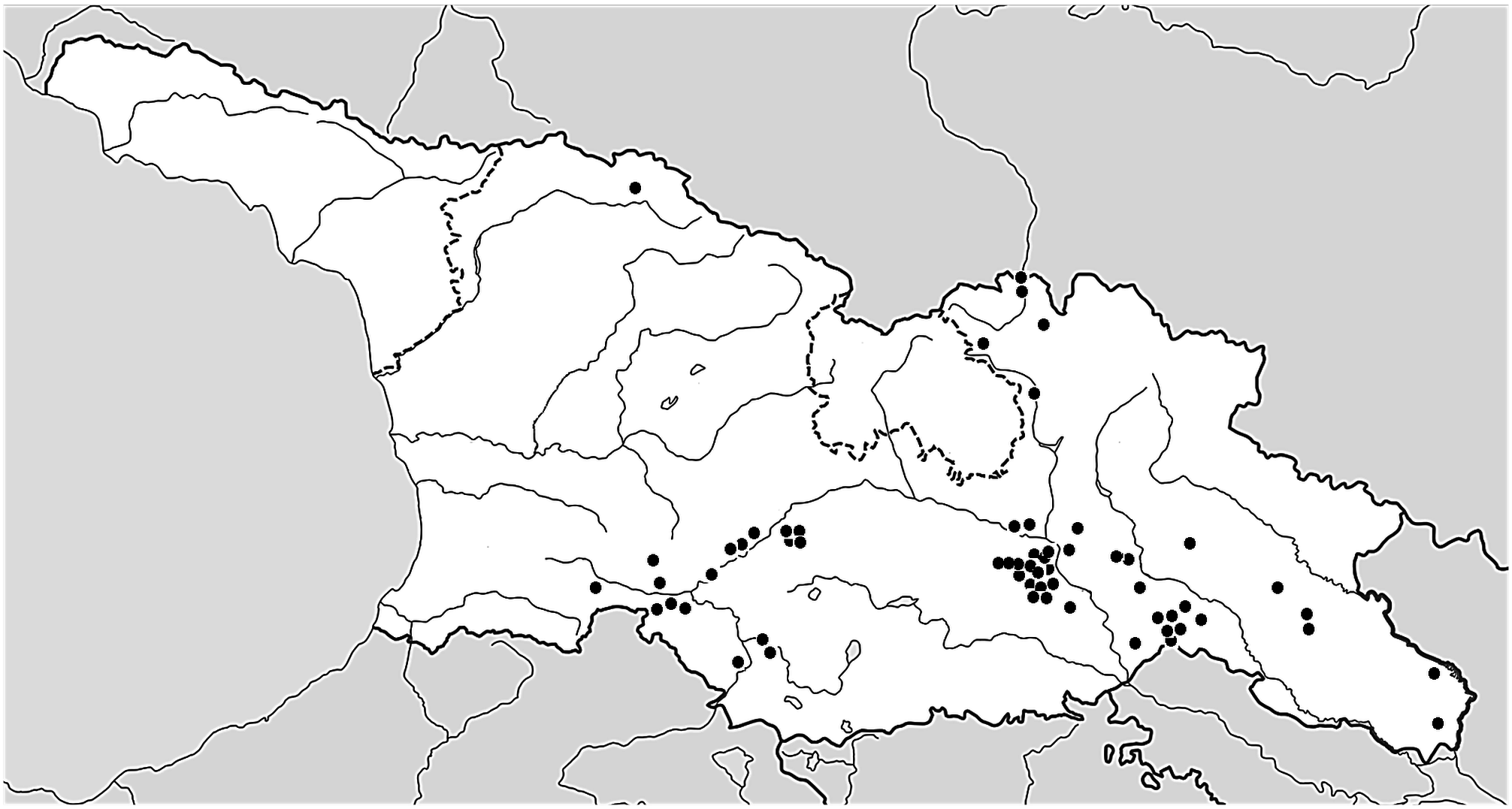
Distribution: —Mainly in the southern, central and eastern parts ( Samtskhe-Javakheti, Tbilisi, Mtskheta-Mtianeti,
Kakheti, Kvemo Kartli provinces), as well as in the northern part of Georgia in the Greater Caucasus, in the northern parts of Samegrelo-Zemo Svaneti and Mtskheta-Mtianeti prov.) ( Fig. 29 View FIGURE 29 ).
Habitat: —Steppes, rocky, loamy, grassy slopes, meadows, edges of fields, abandoned fields, roadsides, ruderal habitats, pastures, railway and road embankments, edges of forests, pine, oak-hornbeam forests, rarely subalpine meadows. The elevation range is diverse, usually (450)600‒1500(2400) m.
Hosts: —Parasitic exclusively on Fabaceae , in Georgia mainly on Medicago sp. , M. sativa L., M. hemicycla Grossh. [ M. sativa nothosubsp. varia (Martyn) Arcang.], M. caerulea Ledeb. [ M. sativa subsp. microcarpa Urb. ].
Phenology: —Flowering May–June (July), fruiting (June) July–August.
Conservation status: —Least Concern (LC). The species has a rather wide distribution in Georgia (7 provinces), EOO is ca. 42,000 km 2, AOO is 2000 km 2. The most common threats are related to habitat degradation, overgrazing and overgrowing.
Taxonomic note: — Orobanche armena Tzvelev in Komarov, Fl. SSSR 23 [Addenda 22]: 686 [99] (1958) [https:// www.ipni.org/n/662130-1].
Ind. loc.: “ Described from Turkey [ Kars], close to its border with Armenia ( Kagyzman, along Kagyzman - Darasu gully close to Araks [ Arax river ], 18.VI.1886, V. Massalskii). Type in Leningrad (LE)” ( Novopokrovsky & Tzvelev 1958: 105) .
Lectotype (designated by Tzvelev 1958: 686 [99]): 1. “ Princeps W. Massalsky: Plantae Lasistanicae Armenia rossica 1886 / 18 июня 1886 КагыЗман [Kagyzman / Kaghzvan / Kağızman] / ... / Kalysman // Orob. major L. var. Beck [m. Beck]”. – 2. “ I. Novopokrovsky. Notae criticae / An potius / Orobanche lutea Baumg. ? / 1949.19.II”. – 3. “ Orobanche armena Tzvelev , sp. nova / Typus! / 1955.III.3 Teste: Tzvelev” (LE01013851, the lectotype (or perhaps holotype) designated by Tzvelev as “Typus”, recently numbered, is formed by a single specimen).
We are not sure the position of this taxon. It is synonymous with O. lutea , according to the idea of the Novopokrovsky label (1949), in opposition to Beck (1930: 249), who considered it to be a var. of O. major sensu Beck (1930) , non L. Gilii (1982: 21) considers it to be an independent species on the basis of this unique collection. We believe that this unique specimen is insufficient for a safe determination and from the area where it was described we have not been able to see anything similar to this specimen.
Specimens examined: — GEORGIA. Kakheti prov.: Dedoplistskaro distr., Vashlovani Park, steppes, ca. 41°10’36”N, 46°32’24”E, 27 May 2014, R. Piwowarczyk (KTC); between Gardabani and Davit Gareja, steppe communities, 41°28’05”N, 45°19’34”E, 750 m, 26 May 2014, R. Piwowarczyk (KTC); S of Lambalo, steppe communities, 41°32’48.7”N, 45°29’52.8”E, 625 m, 27 May 2014, R. Piwowarczyk (KTC); W of Tetri Tsklebi, Gombori pass, steppe hills, 41°51’54”N, 45°17’09.3”E, 1590 m, 23 July 2015, R. Piwowarczyk (KTC); S and SE of Kvemo Bodbe, steppe hills, 41°32.21’N, 45°54.081’E, 765 m, 41°32.351’N, 45°54.326’E, 750 m, 9 May 2019, 12 May 2019, R. Piwowarczyk (KTC); SE of Kvemo Kedi, steppe hills, 41°20.599’N, 46°32.338’E, 700 m, 11 May 2019, R. Piwowarczyk (KTC); S of Chalaubani, embankments on the main road, 41°38.110’N, 45°49.41’E, 730 m, 14 May 2019, R. Piwowarczyk (KTC); SE of Kopatadze lake, steppe slopes, 41°33.845’N, 45°20.056’E, 885 m, 15 May 2019, R. Piwowarczyk (KTC); Udabno, 2 June 1946, E. Kikodze (TGM8732); N of Udabno, steppe slopes, 41°31.387’N, 45°23.068’E, 920 m, 15 May 2019, R. Piwowarczyk (KTC); SW of Udabno, steppe, fallow, 41°29.555’N, 45°21.792’E, 810 m, 15 May 2019, R. Piwowarczyk (KTC); SW and SE of Jikurebi lake, steppe hills, 41°34.320’N, 45°20.154’E, 825 m, 15 May 2019, R. Piwowarczyk (KTC); steppe slope on the road from Sataple [Krasnogorsk] to Sartichala [Marienfeld], 41°41’14.5”N, 45°13’15.1”E, 680 m, 2 June 2022, R. Piwowarczyk (phot.); NW of Ujarma, road to the old sanatorium, clearings, roadsides, and forest edges in oak-hornbeam forests, dry meadows, 41°47’26.5”N, 45°09’02.2”E, 820 m, 2 June 2022, R. Piwowarczyk (phot.); ca. 2.5 km NW of Ujarma, roadsides in thermophilous shrublands, dry meadows, 41°47’49.1”N, 45°08’30.8”E, 840 m, 2 June 2022, R. Piwowarczyk (phot.); Kvemo-Kartli prov.: prov. Tiflis, distr. Borčalo, in declivilatibus montii Jagludzha [range W of Rustavi], 6 June 1921, B. Schischkin (TGM53184, TGM8427) [as O. cumana by Melikischvili]; Transcaucasia, Georgia, prov. Tiflis, steppa Karajazy, prope pag. Michajlovca, 20 May 1929, A. Kolakovsky (BAK); Kojori E, slopes by the asphalt road (Lunkeri Str.), forest edges, 41°39’36.2”N, 44°43’44.9”E, 41°39’37.7”N, 44°43’33.6”E, 1170 m, 1215 m, 6 June 2022, R. Piwowarczyk (phot.); Kojori, slope in the village, on the road towards Azeula Fortress, 6 June 2022, R. Piwowarczyk (phot.); Kojori NW, S of Udzo Monastery, rocky slopes, steppes, edges of forest, 41°40’21”N, 44°41’59”E, 1380 m, 6 June 2022, R. Piwowarczyk (phot.); Mtskheta-Mtianeti prov.: prov. Tiflis, in viciniis Mtschet, in fruticetis faucium Armaziz-chevi (right specimen], 6 June 1920, B. Schischkin (TGM8428) [as O. cumana by Melikischvili]; surroundings of Tiflis, Shiomgvime monastery, 1 June 1919, B. Schischkin (TGM53186) [as O. cumana by Melikischvili]; N of the road from Mtskheta to Shiomgvime monastery, slopes, dry grasslands, 41°50’54.2”N, 44°41’37.4”E, 640 m, 6 June 2014, R. Piwowarczyk (KTC); Mtskheta-Mtianeti, Great Caucasus, road from Terek [Tergi] valley to Juta, 44°44’E, 42°34’N, [ca. 2030 m], 18 July 2002, G. Schneeweiss et al. (WU0027607); W of Kobi, Truso gorge, slopes of the Tergi river, 19 June 2019, G. Łazarski [phot.]; Kazbegi, Truso Valley, 42°35’5.2”N, 44°27’36.2”E, [ca. 2060 m], mountain meadow on the slope, 16 June 2019, G. Łazarski (KTC); N of Tsdo, between two small lakes near confluence of Amali and Terek Rivers, 42.722431N, 44.624444E, [ca. 1500 m], 17 June 2019, S. Thomas, [phot., https://www.inaturalist.org/ observations/33274402]; Kartli (K’art’li, Kartli), eastern part of the Trialeti Mountains (T’rialet’is k’edi, Trialetis kedi), Mount Didgori, surroundings of the village of Der, 41°43’N, 44°30’E, 1200–1300 m, 29 May 2002, G. Schneeweiss (WU0027593, WU0027594); Tsodoreti, slopes, pastures and roadsides in the village, ruderal habitats, near road to the Tsodoreti lake, 41°45’44.1”N, 44°39’10.8”E, 880 m, 10 June 2022, R. Piwowarczyk (phot.); Tsodoreti W, Trialeti range, Tsodoreti lake, slopes near the road from lake to the monastery, 41°45’58.3”N, 44°37’56.5”E, 41°45’59.3”N, 44°37’46.8”E, 940–980 m, 10 June 2022, R. Piwowarczyk (phot.); Mukhatskaro W, 41°44’53.5”N, 44°38’52.3”E, [ca. 1160 m], 8 June 2022, N. Tiunov (phot., https://www.inaturalist.org/observations/120822029); probably near area of Pasanauri distr., 42°18’47.1”N, 44°35’55.4”E [accuracy of 20 km], 13 May 2014, T. Heijnen (phot., https://www.inaturalist.org/observations/36773678); between Saguramo and Sankevani, 41°53’27.8”N, 44°47’37.8”E, 14 May 2023, Katiaflo (phot., https://www.inaturalist.org/observations/161556493); Akhalsopeli, 41°54’08.2”N, 44°47’26.5”E, 11 May 2023, Katiaflo (phot., https://www.inaturalist.org/observations/161026465); Samegrelo-Zemo Svaneti prov.: “Collected by: J.J. Wieringa / no. 8116 d.d.: 26 July 2015 / cf. Orobanche lutea Baumg. / Det. Uhlich H. 24 August 2015 / Georgia, Samegrelo-Zemo Svaneti; 3 km S of / Mestia, Zuruldi mountain. Alpine meadow. / 43°01.09’N 42°44.49’E 2352 m... / ... Stigma yellow” (WAG1575121, WAG8001589); Samtskhe Javakheti prov.: Akhaltsikhe rayon [district], along the forest road near Sapara monastery, 10 July 1946, A. Takhtajan (ERE); rocky slopes and roadsides near the rocky town of Vardzia, 41°22’41”N, 43°16’56”E, 1250 m, 3 June 2014, R. Piwowarczyk (KTC); steppe communities near the road from Akhalkalaki to Diliska, slopes of the river Paravani, 41°25’30.2”N, 43°28’24”E, 1640 m, 11 July 2015, R. Piwowarczyk (KTC); N of Chunchkha vil., rocky slopes of Paravani river, 41°28’32.6”N, 43°23’42.6”E, 1370 m, 11 June 2015, R. Piwowarczyk (KTC); between Ahkaltsikhe and Benara, SW of Parekha vil., rocky steppe, 41°39’04.6”N, 42°52’12.6”E, 1030 m, 12 July 2015, R. Piwowarczyk (KTC); E of Untsa, grazed grasslands in the trees of ash and robinia, roadsides, 41°40’41.6”N, 42°49’56.6”E, 1010 m, 12 July 2015, R. Piwowarczyk (KTC); between Zarzma and Utkisubani, slopes, 41°40’01.2”N, 42°37’25.7”E, 1400 m, 13 July2015, R. Piwowarczyk (KTC); between Skhvilisi and Didi Pamaji, in direction to Vale, steppe hills, 41°37’37.6”N, 42°54’24.1”E, 1090 m, 13 July 2015, R. Piwowarczyk (KTC); between Naokhrebi and Turkish border, steppe hills (few houndreds individuals), 41°35’41.6”N, 42°49’43.1”E, 1230 m, 13 July 2015, R. Piwowarczyk (KTC); Minor Caucasus , valley of river Mtkvari (Kura), between Akaltsikhe and Atskuri, 920–980 m, on Medicago sp. (Fabaceae) , 21 May 2001, G. Schneeweiss & A. Tribsch (WU0022704); Tsaghveri, 23 May 2019, T. Boland [phot., https://www. inaturalist.org/observations/69637332]; Daba E, roadsides, slopes, edges of forest, 41°48’35.4”N, 43°27’12.4”E, 1000 m, 12 June 2022, R. Piwowarczyk (phot.); between Daba and Tsaghveri, roadsides, slopes, 41°48’27.1”N, 43°28’04.0”E, 1025 m, 12 June 2022, R. Piwowarczyk (phot.); Daba E, overgrown slopes with a predominant hornbeam, 41°48’44.6”N, 43°27’34.1”E, 1005–1020 m, 15 June 2022, R. Piwowarczyk (phot.); Chitakhevi E, slopes of the Mtkvari (Kura) river, 41°47’57.7”N, 43°18’50.2”E, 41°47’55.2”N, 43°18’44.2”E, 840–850 m, 16 June 2022, R. Piwowarczyk (phot.); Tbilisi prov.: Transcaucasia, Tiflis, in fruticetus, A. Grossheim, 25 May 1919 (ERE) [only the big right specimen]; prov. et distr. Tiflis, ad riparum dertarum fl. Vera, in fruticetus, 26 May 1920, B. Schischkin (TGM53187) [as O. cumana by Melikischvili]; Transcaucasia, Tiflis, in familus fl. Dabachanca [part of r. Dabakhanka gorge in Botanical Garden], 6 June 1920, A. Grossheim (ERE) [as O. caryophyllacea ]; prov. et distr. Tiflis, Tsavkisi, in agris derelectis, 23 May 1920, B. Schischkin (TGM53181, TGM8426) [as O. caesia by Melikischvili); the Chronicle of Georgia (or History Memorial of Georgia) monument located near Tbilisi sea, dry grasslands communities, ruderal places, 41°46’18.5”N, 44°48’36.4”E, 490 m, 25 May 2014, R. Piwowarczyk (KTC); Tiflis [Tbilisi] (leg. Bayern) ( Beck 1890: 167, sub O. lutea ); Tbilisi, Botanical Garden, rocky hill west of the stone bridge and in front of a modern glass building, N of Mirza Shafi Str., 41°41’12.5”N, 44°47’50.7”E, 510 m, 3 June 2022, R. Piwowarczyk (KTC); Tbilisi, trial from the Marabda Str. to the Turtle lake, slopes, rocky places, pine groves, 41°42’06.7”N, 44°45’49.9”E, 630 m, 4 June 2022, R. Piwowarczyk (phot.); Tbilisi, trial from the Marabda Str. to the Turtle lake, rocky slopes SE from the Turtle lake, 41°41’57.7”N, 44°45’29.6”E, 41°41’57.8”N, 44°45’29.6”E, 740 m, 4 June 2022, R. Piwowarczyk (phot.); prov. et distr. Tiflis, Tschneti (Tskneti), in agris derelictis, 26 May 1920, B. Schischkin (TGM53185) [as O. cumana by Melikischvili]; rocky slopes of Vere river, road from Tbilisi to Tskhneti, near Tskneti Hwy, 41°42’50.6”N, 44°41’49.7”E, 710 m, 5 June 2022, R. Piwowarczyk (phot.); Tbilisi, Lisi Lake SW part, steppe slope between Beritashvili Str. and path around the lake, 41°44’31.3”N, 44°43’47.3”E, 640 m, 10 June 2022, R. Piwowarczyk (phot.).

No known copyright restrictions apply. See Agosti, D., Egloff, W., 2009. Taxonomic information exchange and copyright: the Plazi approach. BMC Research Notes 2009, 2:53 for further explanation.