
Orobanche laxissima Uhlich & Rätzel
|
publication ID |
https://doi.org/10.11646/phytotaxa.604.1.1 |
|
persistent identifier |
https://treatment.plazi.org/id/5464813D-FFF9-FFF1-FF67-AA5C66D3FBA1 |
|
treatment provided by |
Plazi |
|
scientific name |
Orobanche laxissima Uhlich & Rätzel |
| status |
|
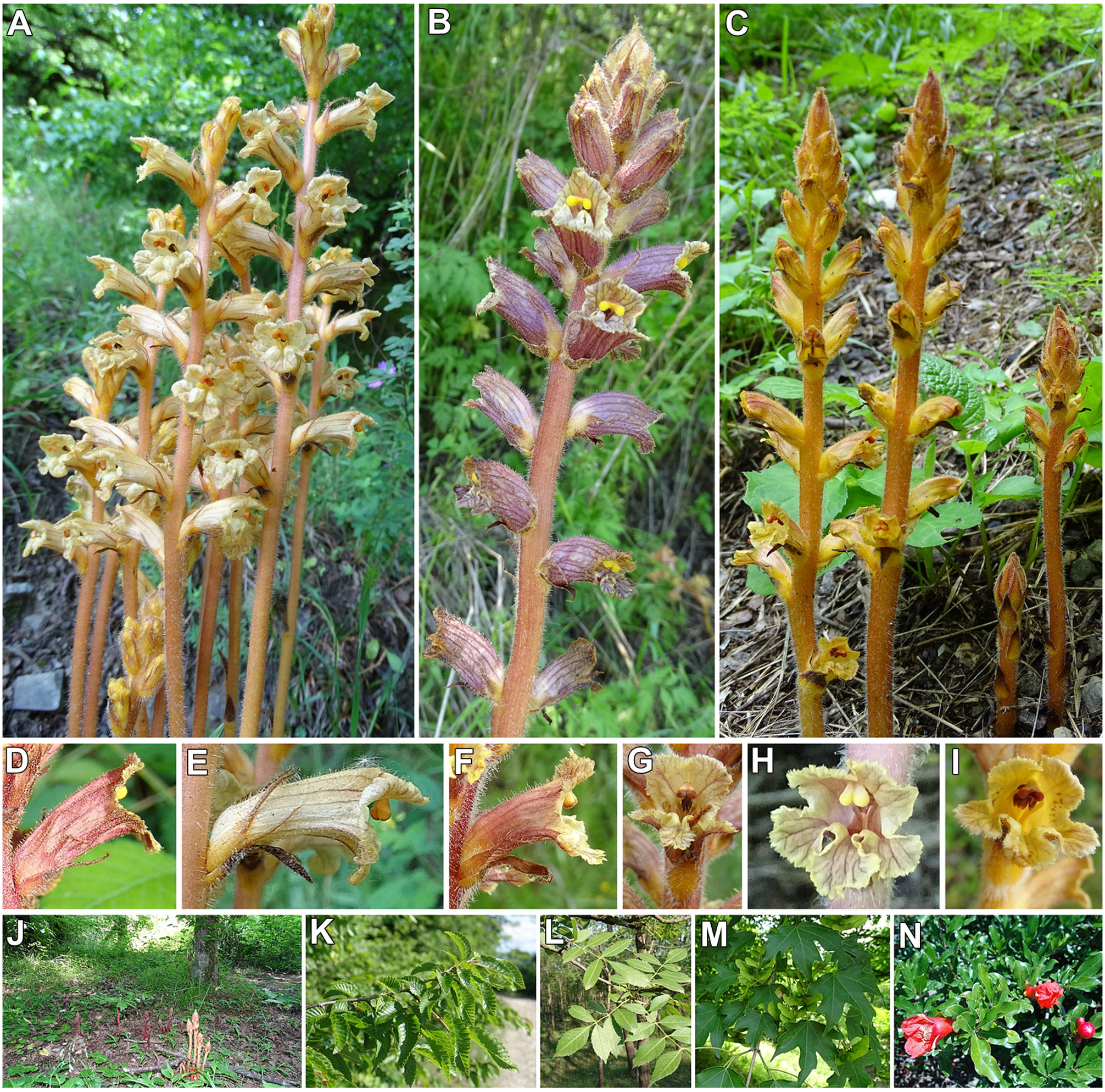
13. Orobanche laxissima Uhlich & Rätzel View in CoL View at ENA in Rätzel & Uhlich (2004: 194)
. TYPE:— RUSSIA ( holotype designated by Rätzel & Uhlich 2004: 196): “in Caucaso boreo-occidentali (Adygaea) prope pagum Novoprokhladnoye, ca. 700 m a. s. l., in fruticetis, leg. S. Rätzel, 30.06.2002 n. 2334” (B101037920 holotype); isotypes (Herb. Rätzel n. 2333 et 2335). Heterotypic synonym:—? O. transcaucasica Tzvelev (1958: 686) ; O. benkertii Rätzel & Uhlich (2004: 190) . Misapplied names:— O. owerinii sensu Beck [p.p.], non O. owerinii (Beck) Beck (1922: 39) . Fig. 44 View FIGURE 44 .
General distribution: —The Caucasus Mountains (Ciscaucasia and Transcaucasia) and, less frequently in forests of Crimea: Armenia, Azerbaijan, Georgia, Crimea, Russia (North Caucasian Federal District [ Dagestan, Kabardino- Balkar, Karachay-Cherkess, Stavropol Krai] and Southern Federal District [ Adygea and Krasnodar Krai]) and N.E. Turkey ( Rätzel & Uhlich 2004, Rätzel et al. 2013, Piwowarczyk & Tatanov 2013, Sánchez Pedraja et al. 2016 +, Piwowarczyk in Nobis et al. 2018, Piwowarczyk et al. 2019).
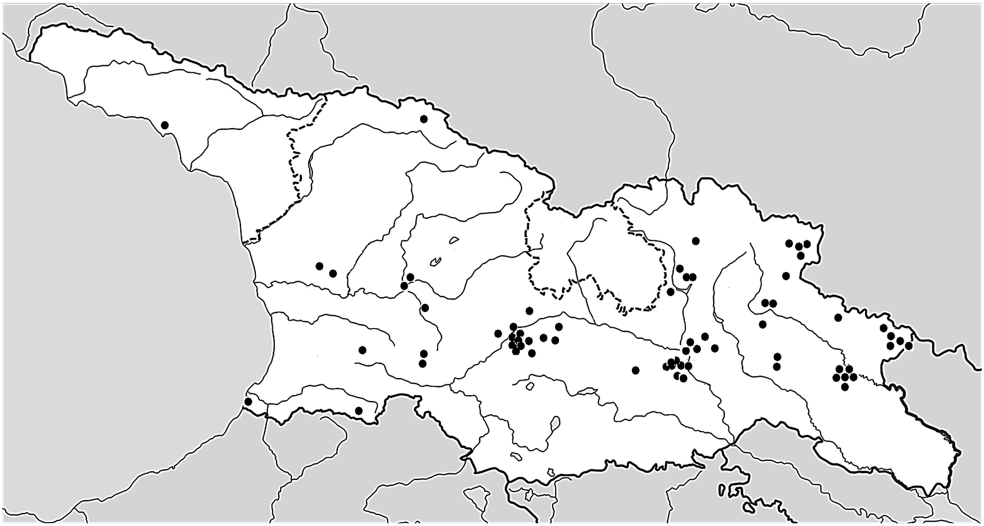
Distribution: —Scattered localities, manly in the central and eastern parts, in Adjara, Guria, Imereti, Kakheti, Shida Kartli, Kvemo Kartli, Mtskheta-Mtianeti, Samegrelo-Zemo Svaneti, Samtskhe-Javakheti, Tbilisi provinces, and Abkhazia ( Fig. 45 View FIGURE 45 ).
Habitat: —In Georgia usually moist, shady or semi-shady places in deciduous forests (“silvis”), especially hornbeam-oak, hornbeam-beech, roadsides on the edge of the woods and roads, shrublands, city parks, botanical gardens, or on wild but also cultivated plants like pomegranate, usually from 30 m near the Black Sea to (200)600‒ 1800(2700) m. In the Lagodekhi reserve, O. laxissima grew in numerous populations in the unique East Caucasian submontane to montane hornbeam-maple-Oriental beech forests, mixed with the hornbeam-chestnut-oak forests, with Hyrcanian elements. Sometimes we can observe it in less forested places, parasitizing Rhus coriaria (Lagodekhi) , and also in some regions of Russia ( Krasnodar), e.g. on coastal cliffs of the Black Sea, and Turkey.
Hosts: —In the Caucasus, polyphagous root parasite of trees and shrublands (e.g., Piwowarczyk et al. 2019, Sánchez Pedraja et al. 2016 +). Moreover, recent reports have indicated the potential parasitism of economically significant forest and fruit tree plantations ( Piwowarczyk et al. 2020, 2021b, c). In Georgia, it was found on Fraxinus excelsior L., F. angustifolia Vahl , F. pallisae Wilmott , Ligustrum vulgare L. ( Oleaceae ), Fagus orientalis Lipsky (Fagaceae) , Carpinus betulus L. [syn. C. caucasica Grossh. ], C. orientalis Mill. (Betulaceae) , Corylus avellana L. ( Corylaceae ), Punica granatum L. ( Lythraceae ), Acer campestre L., A. cappadocicum Gled. (syn. A. laetum C.A. Mey. ), A. velutinum Boiss. (Sapindaceae) , Rhus coriaria L. ( Anacardiaceae ), Robinia pseudoacacia L. ( Fabaceae ).
Phenology: —Flowering (May) June to July, fruiting July–August.
Conservation status: —Least Concern (LC). The species has a rather wide distribution in Georgia and populations are usually very numerous. EOO is 45,000 km 2 and AOO is ca. 3000 km 2. In some places, habitat loss due to deforestation and loss of hosts may be the main threat.
Taxonomic notes: — Orobanche laxissima is a very polymorphic species and has a very variable colouration, and other morphological features; it can be confused with O. owerinii (even Beck himself confused them), especially in the herbarium materials without details about the host. Sometimes it also occupies similar habitats, appearing together with O. hederae Duby.
Moreover, O. laxissima seems to be very similar, if not the same, morphologically to O. transcaucasica Tzvelev in Komarov (1958: 686), described from a “silva mixta ( Carpineto-Quercetum)” of the Shemackha region in Azerbaijan (BAK0-0000063, very damaged material not determinable with certainty (see notes in Piwowarczyk et al. 2019; Piwowarczyk et al. 2021a).
We also believe that the described species, of this same district (Maykopsky) and republic (Adygaea), under the name of O. benkertii (B101037921 and B101037940), in the same work by these authors, corresponds to the same species and are apparently not fully developed forms ( Rätzel & Uhlich 2004: 191 “Abb. 1”) of this typical species of Caucasian forests, although the host-plants (casual/mistaken?) indicated are not usual for this species.
In order to avoid disadvantageous nomenclatural changes entailed by the strict application of the rules ( Turland et al. 2018: Art. 14), we think that the name used for this species must be O. laxissima due to it being the most widely accepted and well-established species name.
Specimens examined: — GEORGIA. Abkhazia: “... Иванов, А.П. [Ivanov, A.P.], Растения окрестностей Сукхуми [Plants of environs of Sukhumi] / 1888-04-17 / Orobanche Epithymum DC. / = O. alba Steph. / Собр. Иванов А.П. [Ivanov A.P.] (MW0723405, sub cf. O. laxissima Rätzel & Uhlich ) [surroundings of Sokhumi, 17 April 1888, A.P. Ivanov]; Adjara: Kvariati, scree forests above the main road in the village, 41.5465394°N, 41.5644658°E, 13 July 2017, D. Zukal [phot.]; distr. Shuakhevi, Adjara, vil. Shubani, forest sides, 14 June 2015, N. Memiadze (BATU) [as O. crenata ]; Guria prov.: Ajara-Imereti range, Bakhmaro, 30 July 1947, G. Tatishvili & A. Dmytrieva (BATU) [badly preserved specimen; as O. crenata ]; Imereti prov.: Kutaisi, May 1853, Anonymous (LE), [mixed collection with Phelipanche purpurea , O. picridis and O. owerinii ]; Imeretia, ad fl. Rion, June 1877, A.H. & V.F. Brotherus (LE) [as O. owerinii ]; Motsameta— Carpinus betulus and C. orientalis forests, on a shady limestone slope below the Motsameta monastery, 42.2831400°N, 42.7590681°E, 24 July 2019, P. Novák [phot.]; Imereti, Kutaisi-Baghdati, Fischer et al. (2018) [phot.]; Kakheti prov.: Gomboris kedi mountain range, village Sighnaghi, 45°55’E, 41°37’N, 700–730 m, 10 July 2002, G. Schneeweiss et al. (WU27636, WU27637); Gombori Range, Sighnaghi NE, in the direction of Tsnori, roadside serpentine road on the edge of the deciduous forest, on C. caucasica , 41°37’19.2’’N, 45°55’50.7’’E, 650 m, 26 May 2014, R. Piwowarczyk (KTC); Sighnaghi NE, the roadside on the outskirts of deciduous forest, on Fraxinus angustifolia , 41°37’20’’N, 45°55’47’’E, 660 m, 26 May 2014, R. Piwowarczyk (KTC); between Sighnaghi SSE, in the direction of Bodbe, ash and maple forests with Cornus , on Carpinus caucasica , population consisting of several thousand shoots, 41°36’39.5’’N, 45°55’21.1’’E, 785 m, 28 May 2014, R. Piwowarczyk (KTC); N from Sighnagi, behind the walls, near Lolashvili Street, thermophilic thickets formed by scrub hornbeams and ligusters, on the E slope of the hill, 14 June 2019, G. Łazarski (KTC); Sighnagi, slope of the hill, 15 June 2019, J. Marciniuk (herb. J. & M. Marciniuk); Anaga S, serpentine road to Sighnagi, edge of forest and shrublands, on Fraxinus , 41°38.255N, 45°54.784E, 610 m, 16 May 2019, R. Piwowarczyk (KTC); between Sighnagi and Tsnori, slopes, roadsides, on Punica , 41°37.375N, 45°56.303E, 16 May 2019, R. Piwowarczyk (KTC); Antoki S, near Sagarejo, roadside on the edge of deciduous scrubs, on C. caucasica , 41°44’03.8’’N, 45°22’21’’E, 765 m, 29 May 2014, R. Piwowarczyk (KTC); Giorgitsminda E near Sagarejo, ash cultivation near the road in the direction of Antoki, W of old russian abandoned bases, on F. angustifolia and F. pallisae , several thousand shoots, 41°43’15.2’’N, 45°22’19.7’’E, 755 m, 29 May 2014, 14 May 2019, R. Piwowarczyk (KTC); Naturreservat Lagodekhi [Lagodekhis nakrdzali (Lagodekhi reserve)], Laubwald im unteren Talabschnitt, 19 May 2001, G. Schneeweiss & A. Tribsch (WU22568); forest reserve of Lagodechi (Lagodechis nakrdzali), 46°16’02”E, 41°50’31”N, 600–1300 m, 10 July 2002, G. Schneeweiss et al. (WU32441, WU32442); Lagodekhi Park, N of Rachisubani, forest, on Fagus orientalis and Acer laetum , 41°49’03”N, 46°18’07”E, 450 m, 21 July 2015, R. Piwowarczyk (KTC); Lagodekhi Park, N of Rachisubani, forest, on Rhus coriaria , 41°49’02”N, 46°18’06”E, 445 m, 16 May 2019, R. Piwowarczyk (KTC); Lagodekhi Park, N of Rachisubani, forest, on F. orientalis and A. laetum , 41°49’04”N, 46°18’06”E, 711 m, 21 July 2015, R. Piwowarczyk (KTC); Lagodekhi Reserve—mesophilous forests with C. betulus , along the Shromis-Khevi River, above the village, 41.8600747°N, 46.2893381°E, 4 August 2018, P. Novák [phot.]; Lagodekhi, town park on the NE edge of the town, C. betulus dominates, 41.8336522°N, 46.2823428°E, 12 July 2016, P. Novák [phot.]; Kveda Pona SW, 41°51’11.1”N, 46°06’35.6”E, 7 June 2023, V. Mitin (phot., https://www.inaturalist.org/observations/166063179); between Lechuri and Abano (S of Omalo, Tusheti region), in the forest slopes on both sides of the road, on F. orientalis , C. avellana , 42°12’47.5”N, 45°28’00.6”E, 1300 m, 22 July 2015, R. Piwowarczyk (KTC); Babaneuri, Babaneuri Reserve— xeromesophilous forests of C. betulus , C. orientalis and Zelkova carpinifolia above the village, 42.0882447°N, 45.3841033°E, 630 m, 6 August 2018, P. Novák [phot.]; Pshaveli—a forest on a slope above the Stori River, 2 km NNW from a road bridge on Stori River in the village, 42.0975000°N, 45.4265278°E, 10 July 2016, P. Novák [phot.]; Zemo Khechili—a slope above the left bank of the Kabali River, 5.3 km NE from the village, 41.9263056°N, 46.1798889°E, 660 m, 5 Aug 2018, P. Novák [phot.]; Kvareli—Kvareli (distr. Kvareli), forest on an upper terrace of the Duruji River, 3.3 km NE from the N edge of the town, 41.9995000°N, 45.8485556°E, 760 m, 5 Aug 2018, P. Novák [phot.]; Tusheti, right side of riv. Chanchakovani, near vil. Khiso, broadleaf forest, 1800 m, 26 July 1988, R. Gagnidze et al. (TBI) [as O. gamosepala ]; Tusheti, right side of riv. Chanchakovani, between Khiso and Nakhiduri, 1800 m, 26 July 1988, R. Gagnidze et al. (TBI) [as O. raddeana ]; Tiflis governorate, Telavi distr., near Kvemo Khodasheni, 6 June 1916, A.N. Pietunnikov (LE) [as O. lutea ]; Kvemo Kartli prov.: prov. et distr. Tiflis, Manglis [Manglisi], in pineto, 27 June 1920, 30 June 1920, 21 July 1920, 3 July 1921, 4 July 1921, O. Zedelmejer (TGM42204, TGM42205, TGM42207, TGM42208, TGM42214) [as O. caryophyllacea , O. anatolica , O. lutea by O. Zedelmejer]; surroundings of Tiflis, Kojori, 13 July 1919, B. Schischkin (TGM5934) [as O. galii ]; eastern part of the Trialeti Mts. (T’rialet’is k’edi, Trialetis kedi), ca. 2 km W Kojori (Kodžori), 44°41’E, 41°40’30”N, 1000 m, 13 July 1997, P. Scĥnswetter & A. Tribsch (WU27672), [as O. transcaucasica ]; Kartli, Didgori-Nichbisi, 1200 m, Fischer et al. (2018) [phot.]; Mtskheta-Mtianeti prov.: Saguramo, 6 July 1919, B. Schischkin (TGM53204) [as O. purpurea by Melikischvili]; Saguramo Range, Saguramo SSE, 300 m E of St. George church, hornbeam-maple forest, on C. caucasica , 41°53’26”N, 44°45’57”E, 690 m, 6 June 2014, R. Piwowarczyk (KTC); surroundings of monastery Sedaseni [Zedazeni], 44°46’40”E, 41°52’49”N, 1000–1200 m, 11 July 2002, G. Schneeweiss et al. (WU27626, WU27627, WU27628, WU27629, WU27630); Tianeti, in silva Sabaduri, 5 July 1960, Melikischvili (TGM11287, TGM11288) [as O. caesia by Melikischvili]; Monument Bidara 3 km NW above Gudauri, 44°27’10”E, 42°29’33”N, 2319 m, 17 July 2002, G. Schneeweiss et al. (WU27624, WU27625);Ananuri—mesophilous forests with C. betulus above the Ananuri monastery, 42.1637661°N, 44.6987911°E, 7 July 2015, P. Novák [phot.]; Chartali—a forest on a slope above the left bank of the river, 0.9 km WSW from the Vashlobi settlement, 42.2889444°N, 44.7215000°E, 9 August 2018, P. Novák [phot]; Tezami, 12 June 2020, D. Maisuradze [phot., https://www.inaturalist.org/observations/49689803]; Mukhatskaro W, 41°45’08.4”N, 44°38’52.6”E, [ca. 1060 m], 41°45’02.8”N 44°38’35.8”E, [ca. 1200 m], 17–18 June 2022, N. Tiunov (phot., https://www.inaturalist.org/observations/122311840, https://www.inaturalist.org/observations/122149989); Zahesi W, 41°49’36.1”N, 44°44’36.1”E, [ca. 480 m], 11 June 2022, Shtepbraiter (phot., https://www.inaturalist.org/ observations/121196571); Dusheti: Tsiprani, hornbeam forest with C. orientalis on the slope of the ESE orientation above the right bank of the Aragvi river, ca. 640 m north of the road bridge over the river, 42°13’33.2”N, 44°50’03.4”E, 935 m, 14 September 2022, P. Lustyk (observ.), field number: GE-PL-22/03; Dusheti: Tsiprani, oak forest with Quercus iberica on the slope of the SE orientation above the right bank of the Aragvi river, cca 670 m north of the road bridge over the river, 42°13’33.9”N, 44°50’04.8”E, 920 m, 19 September 2022, P. Lustyk (photo number: P1045117), field number: GE-PL-22/04; Dusheti: Betischrdili, beech forest with Fagus orientalis and Fraxinus excelsior on the slope ENE orientation above right bank of the Aragvi river, cca 2.3 km SSW of the confluence of Pshavis Aragvi river and Kevshuretis Aragvi river, cca 5.1 km NNE(–N) of the Khomi hotel, 42°24’41.6”N, 44°55’23.2”E, 1250 m, 29 September 2022, P. Lustyk (photo number: P1045282, P1045285, P1045287, P1045291), field number: GE-PL-22/39; Samegrelo-Zemo Svaneti prov.: Senaki—ravine 2 km NW from the town, 42.2925556°N, 42.0404444°E, 11 July 2017, V. Kalníková & P. Novák [phot.]; Tskemi—alluvial forest with Alnus glutinosa subsp. barbata and Carpinus betulus , 1.7 km ESE from the centre of the village, 42.2557581°N, 42.1864111°E, 10 July 2017, P. Novák [phot.]; Mestia N, Quercus macranthera forest 43°3’23.332”N, 42°43’16.551”E, [ca. 2020 m], August 2022, P. Novák [phot.]; Samtskhe-Javakheti prov.: Transcaucasia, Tiflis, distr. Gori, prope pagum Bakuriani, 5000 ft., 18 August 1919, A. Grossheim (ERE) [as O. lutea ]; prov. Tiflis, distr. Gori, Bakuriani, in silva prope p. Sokačavi, 26 July 1920, B. Schischkin (TGM53183) [as O. caryophyllea by Melikischvili]; Borjomi, 22 July 1894, O.A. & B.A. Fedchenko (LE; as O. crenata ); Borjomi, 2700 m, 8 July 1887, Akinfiew (LE; as O. crenata ), mounted with Borjomi, 5500’, 28 June 1888, Akinfiew s.n. (LE; as O. crenata ); Borjomi, park, 20 May 1910,?, (TGM52886) [as O. lutea by Melikischvili]; distr. Borjomi, Borjomi park, near mineral water, 24 July 1948,? (BATU) [as O. crenata ]; Borjomi, the main street in the direction of the entrance to the Borjomi Central Park, scrubs at the foot of the rocks in the valley of the Borjomula river, mainly on Carpinus caucasica , 41°50’15”N, 43°23’16”E, 820 m, 1 June 2014, R. Piwowarczyk (KTC); Borjomi, Borjomi Central Park, gorge in deciduous forest in Borjomula river valley, on Fraxinus , Acer , Carpinus , 41°49’55.1”N, 43°23’37.4”E, 830 m, 14 June 2022, R. Piwowarczyk (KTC); Borjomi, near the sanatorium, forest, July 2011, M. Podsiedlik [phot.]; Daba E, overgrown slopes with a predominant hornbeam, on Carpinus and A. campestre , 41°48’44.6”N, 43°27’34.1”E, 1005–1020 m, 15 June 2022, R. Piwowarczyk (phot.); between Chitakhevi and Likani, the slope of the valley Chitakhevi river in the forest near Green (Mtsvane) Monastery, on Fraxinus , 41°48’35.8”N, 43°18’39.84”E, 945 m, 14 July 2015, R. Piwowarczyk (KTC), 16 June 2022, R. Piwowarczyk (phot.); Mtsvane Monastery (Green Monastery), forest edge, rocky slope, 41.73056°N, 043.35369°E, 986 m, M. Khutsishvili et al. (phot.); 12 September 2022, prov. Tiflis, distr. Gori, vil. Tsaghveri, 15 July 1930, W. Kozlowsky (TBI) [as O. caryophyllacea ]; western part of the Trialeti Mts. (T’rialet’is k’edi, Trialetis kedi), surrounding of Timot’esubani monastery (Timotesubani), ca. 3 km E Tsaghveri, 43°31’E, 41°49’N, 1200 m, 16 July 1997, P. Scĥnswetter & A. Tribsch (WU27673); Untsa E, woodlots near the road to Varkhani, on Fraxinus , Robinia pseudoacacia , 41°40’41.6”N, 42°49’56.6”E, 1006 m, 12 July 2015, R. Piwowarczyk (KTC); Adigeni distr., near Abastumani, Zekari pass, 2000 m, Pinus-Picea forest with Abies , 23 June 1980, Ju. Menickij (LE) [as O. owerinii ]; Tiflis governorate, Gori distr., between Bakuriani and Imereti hills, subalpine meadows, 1 June 1916, P.I. Krylov & E.I. Shteinberg (LE) [as O. crenata , O. alsatica , O. owerinii ; with Apiaceae on the herbarium sheet]; Shida Kartli prov.: Georgia, Gori distr., Dzama gorge, vil. Sative, N slope, [ca. 41.883117°, 43.630862°], 19 July 1938, T. Partskhaladze (TGM42211) [as O. lutea by T. Partskhaladze]; Georgia, Gori district. above the village Dzama, the left side of Khashuri gorge [ca. 41.924636°, 43.625307°], forest edge, 18 July 1938, T. Partskhaladze (TGM5935) [as O. lutea ]; Georgia, Gori distr., Dzama gorge, vil. Legvischala [ca. 41.959378°, 43.801097°], 28 July 1938, T. Partskhaladze (TGM42212) [as O. lutea by T. Partskhaladze]; Khashuri, environs of village Tsivtskaro [ca. 42.055913°, 43.539969°], forest edge, 20 July 1952, V. Papava & M. Melikischvili (TGM) [as O. owerinii by V. Papava & M. Melikischvili]; Tbilisi prov.: Tiflis, Botanical Garden, ad radices Carpini, July 1930, D. Sosnowsky (TBI) [as O. gracilis ]; Transcaucasia, Tiflis, Vera [Vera it is a district in old town of Tbilisi with numerous gardens and parks], 22 June 1919, 27 June 1920, Grossheim (ERE) [as O. lutea ]; Transcaucasia, Tiflis, in fruticetus [badly preserved specimen, need confirmation], 25 May 1919, A. Grossheim (ERE) [as O. aegyptiaca ].
No known copyright restrictions apply. See Agosti, D., Egloff, W., 2009. Taxonomic information exchange and copyright: the Plazi approach. BMC Research Notes 2009, 2:53 for further explanation.