
Therlinya monteithi, Gray & Smith, 2002
|
publication ID |
https://doi.org/ 10.3853/j.0067-1975.54.2002.1368 |
|
persistent identifier |
https://treatment.plazi.org/id/573AD206-1354-FFE5-DA7D-FC0FFD41C30F |
|
treatment provided by |
Carolina |
|
scientific name |
Therlinya monteithi |
| status |
|
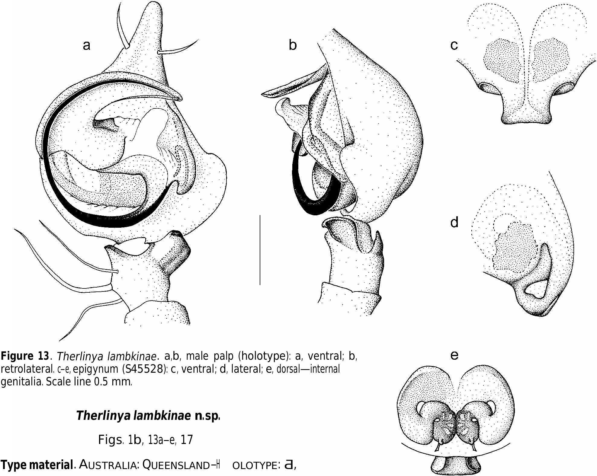
Therlinya lambkinae n.sp.
Figs. 1b, 13a–e, 17
Type material. AUSTRALIA: QUEENSLAND—H
OLOTYPE: Ƌ,
QM S45527 View Materials , Cowley Creek , E of Mount Molloy, 16°42'S 145°23'E, 3–10 Nov. 1975 GoogleMaps , R. Raven & V.E. Davies, lacy web with retreat to rotting logs. PARATYPES: ♀ , QM S45528, data as for holotype; Ƌ, 2♀♀ GoogleMaps , QM S42260 View Materials , data as for holotype; ♀, KS58323, Ƌ, KS58324, Goldsborough Valley SF, 4.1 km S of Mulgrave River crossing, 17°14'S 145°46'E, 23 May 2000 GoogleMaps , G. Milledge & H.M. Smith, rainforest, sheet webs out from retreats in almost vertical earth bank on roadside; ♀, KS4166, Mt Lewis , 16°35'S 145°17'E, 19 Aug. 1978 GoogleMaps , R. Mascord; ♀, KS34799, Gordonvale–Atherton Rd , just S of Lake Barrine turn-off, 17°15'S 145°38'E, 16 Nov. 1975 GoogleMaps , M. R. Gray, medium-size sheet web woven among leaf litter and going into bank hole c. 4 cm deep, ♀ with round egg sac attached to roof; Ƌ, KS42608, Mt Spurgeon , 16°26'S 145°12'E, 19 Apr. 1994 GoogleMaps , M. Moulds & J. Thompson, eucalypt forest, messy platform above retreat under log; Ƌ, KS58325, ♀, KS58326, Goldsborough Valley SF, c. 1.5 km N of campsite, 17°14'S 145°46'E, 22 May 2000 GoogleMaps , G. Milledge & H.M. Smith, rainforest, sheet webs out from retreats in almost vertical earth bank on roadside; Ƌ, KS58327, Cape Kimberley Rd , 2.7 km from Cape Tribulation Rd, 16°15'58"S 145°27'35"E, 20 May 2000 GoogleMaps , G. Milledge & H.M. Smith , in rotting log; ƋƋ , QM S14104 View Materials , Paluma Dam Rd, 19°00'S 146°10'E, 2 Sep. 1988 GoogleMaps , R. Raven, J. Gallon & T. Churchill, fringe rainforest; Ƌ , QM S16725 View Materials , Mossman Bluff track, 5–10 km W of Mossman, 16°27'S 145°18'E, 20 Dec. 1989 – 15 Jan. 1990 GoogleMaps , Monteith, Thompson & ANZSES, 760 m, site 5 flight intercept; Ƌ, QM S17862 View Materials , Mt Elliot , summit, 19°30'S 146°57'E, 26 Mar. 1991 GoogleMaps , G. Monteith & D. Cook , 1150 m .
Other material. AUSTRALIA: QUEENSLAND ♀, QM S17874 View Materials , Mt Elliot, North Creek , 19°29'S 146°57'E, 25–27 Mar. 1991, G. Monteith & D. Cook, 1000 m GoogleMaps ; ♀, QM S24424 View Materials , Mt Halifax , 19°07'S 145°23'E, 19–21 Mar. 1991, G. Monteith & D. Cook, E/W ridge, 900 m GoogleMaps ; Ƌ, ♀, QM S42261 View Materials , Mt Lewis , 12 Sep. 1971, N. Clyde-Coleman ; ♀, QM S42267 View Materials , Mossman Bluff track, 9 km W of Mossman, 16°27'S 145°17'E, 20–24 Dec. 1989, Monteith, Thompson & ANZSES, 1000 m GoogleMaps ; Ƌ, QM S42268 View Materials , Mossman Bluff track, 5–10 km W of Mossman, 16–30 Dec. 1988, Monteith, Thompson & ANZSES, 1000 m , site 7, flight intercept; ♀, QM S42273 View Materials , Emerald Creek, Lamb Range , c. 17°04'S 145°35'E, 11 Oct. 1982, Monteith, Yeates & Thompson, 950 m GoogleMaps ; ♀, QM S42280, en route to Flat Peak, Cape Tribulation Rd , 16°15'S 145°25'E, 27 Jul. 1991 GoogleMaps , T. Churchill , 400 m ; ƋƋ, QM S42284 View Materials , 3 km S Mt Spurgeon , 16°27'S 145°11'E, 20–22 Nov. 1997, D.J. Cook, 1100 m GoogleMaps , pitfall traps, open forest; Ƌ, QM S42285 View Materials , Mt Spurgeon , 16°27'S 145°12'E, 19 Nov. 1997 – 8 Feb. 1998, Monteith & Cook, 1120 m GoogleMaps , O/F trap 5, pitfall;ƋƋ, QM S42286 View Materials , Mt Spurgeon , 16°28'S 145°12'E, 19 Nov. 1997 – 8 Feb. 1998, Monteith & Cook, 1110 m GoogleMaps , O/F trap 6, pitfall; Ƌ, QM S42287, Mt Spurgeon , 16°28'S 145°12'E, 20 Nov. 1997 – 8 Feb. 1998, Monteith & Cook, 1120 m GoogleMaps O/F trap 7, pitfall; Ƌ, QM S42290 View Materials , Black Mountain , 17 km ESE of Julatten, 16°39'S 145°29'E, 29– 30 Apr. 1982, Monteith, Yeates & Cook, 800–1000 m GoogleMaps ; Ƌ, QM S42296 View Materials , Mt Spec , 18°55'S 146°10'E, 6 Feb.–9 Mar. 1995, M. Cermak, 880 m GoogleMaps , S2, malaise trap; Ƌ, QM S42297 View Materials , Seaview Range, Mt Fox Rd , c. 18°51'S 145°50'E, 15 Dec. 1986, Monteith, Thompson & Hamlet GoogleMaps , RF, 600 m ; ƋƋ, QM S42298 View Materials , Paluma Dam Rd , site 3, 8 Dec. 1990 – 5 Feb. 1991, Monteith & Seymour, 800 m , flight intercept trap; ƋƋ, QM S42299 View Materials , Paluma Dam Rd , site 1, 8 Dec. 1990 – 5 Feb. 1991, Monteith & Seymour, 900 m , flight intercept trap; ƋƋ, QM S42300 View Materials , Paluma Dam Rd , site 5, 8 Dec. 1990 – 5 Feb. 1991, Monteith & Seymour, flight intercept trap; ƋƋ , QM S46801 View Materials , Mt Halifax summit, 19°07'S 145°23'E, 21 Mar.–10 May 1991, D. Cook, pitfalls & intercepts GoogleMaps .
Diagnosis. CL 2.94–4.69. Separated from all species, except other northern Queensland species, by weakness of leg banding; from T. monteithi View in CoL by larger size of scape and
smaller RTA; from T. angusta by greater width of scape and relatively wider cymbial flange; from T. nasuta by presence of scape.
Male (holotype). BL 6.78, CL 3.59 (2.94–4.69), CW 2.45, CapW 1.51, EGW 0.94, LL 0.55, LW 0.53, SL 1.84, SW 1.47. Legs: 1243 (I 17.42, II 15.83, III 12.67, IV 15.50); ratio tibia I length:CW = 1:0.55. Male palp: Fig. 13a,b View Figure 13 . Cymbium wide with strongly developed retrolateral flange. Bulb wider than long; tegular lobe placed retrolaterally, with prominent conical base. Embolus origin retrolateral. Stem of T-shaped conductor prolaterally directed, posterior limb placed prolaterally; tegular window large, placed basally. RTA dorsad, hidden in ventral view; RVTA broad, width about half tibia length, with beak-like apex turned toward upper side in ventral view.
Female (S45528). BL 7.35, CL 3.47 (3.27–4.29), CW 2.20, CapW 1.67 EGW 0.98, LL 0.55, LW 0.55, SL 1.63, SW 1.31. Northern colour pattern. Legs: 1423 (I 12.25, II 10.50, III 8.67, IV 10.67); ratio tibia I length:CW = 1:0.71. Epigynum: Fig. 13c,d View Figure 13 . Scape wide, sides gently concave, most of scape placed behind level of epigastric groove; in side view distoventral scape curved inwards, not protuberant; epigynal fossae oriented diagonally. Internal genitalia: Fig. 13e View Figure 13 .
Variation. Epigynal scapes vary in width, the widest being those from Mt Lewis and near Lake Barrine.
Distribution. Northeastern Queensland from the Townsville region northwards to the Daintree region.
Etymology. The specific name is in honour of Christine Lambkin, the illustrator of the type specimens.
| QM |
Queensland Museum |
| R |
Departamento de Geologia, Universidad de Chile |
| V |
Royal British Columbia Museum - Herbarium |
| T |
Tavera, Department of Geology and Geophysics |
No known copyright restrictions apply. See Agosti, D., Egloff, W., 2009. Taxonomic information exchange and copyright: the Plazi approach. BMC Research Notes 2009, 2:53 for further explanation.
|
Kingdom |
|
|
Phylum |
|
|
Class |
|
|
Order |
|
|
Family |
|
|
Genus |