
Myrmecia pilosula Fr. Smith
|
publication ID |
https://doi.org/ 10.11646/zootaxa.3911.4.2 |
|
publication LSID |
lsid:zoobank.org:pub:EDF9E69E-7898-4CF8-B447-EFF646FE3B44 |
|
DOI |
https://doi.org/10.5281/zenodo.3511651 |
|
persistent identifier |
https://treatment.plazi.org/id/660EEE4F-671E-FF9F-FF59-FB67FC0AFDB6 |
|
treatment provided by |
Plazi |
|
scientific name |
Myrmecia pilosula Fr. Smith |
| status |
|
Myrmecia pilosula Fr. Smith View in CoL (Western Race)
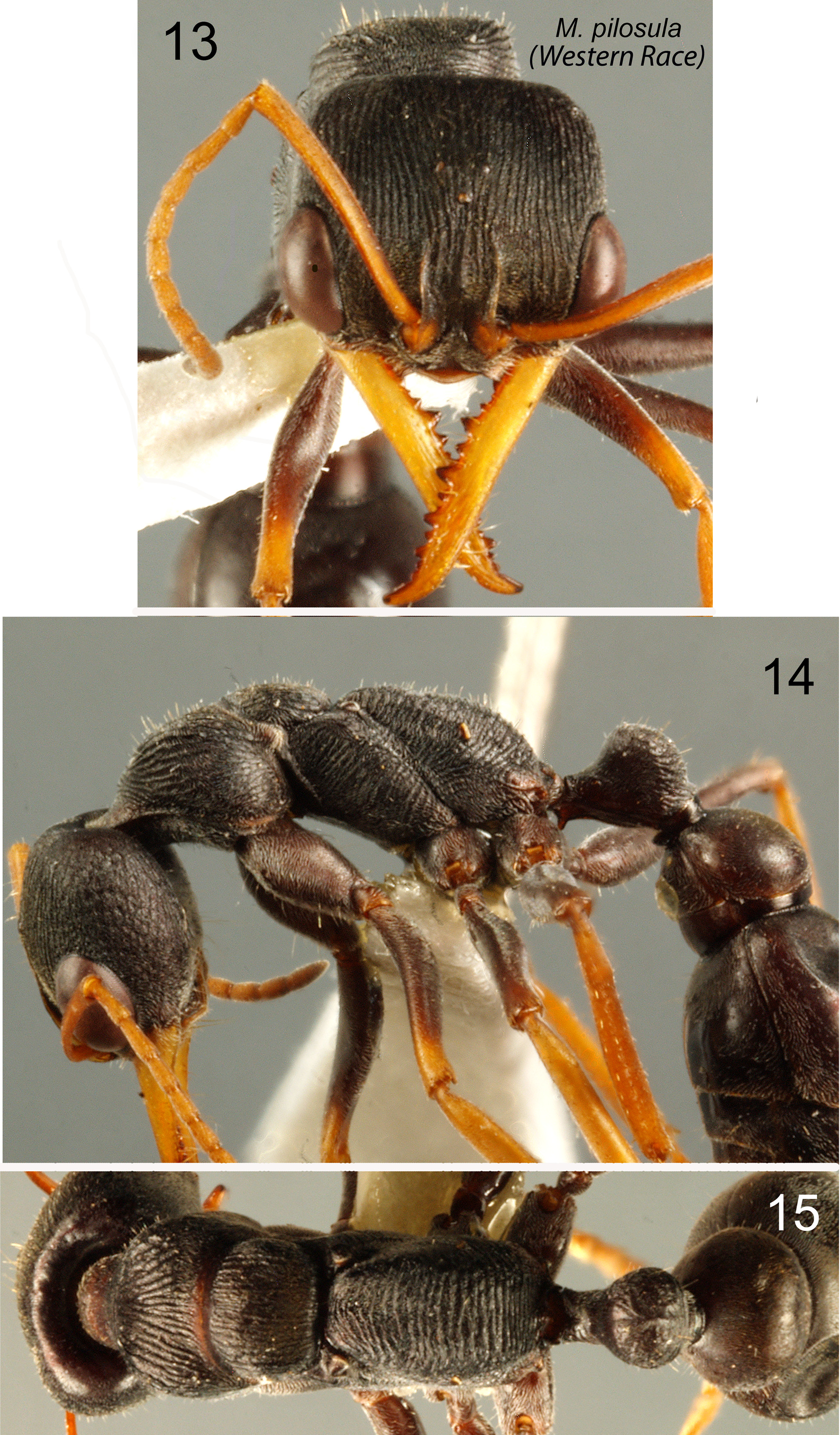
( Figs 13–15 View FIGURES 13 – 15 )
Myrmecia pilosula Fr. Smith, 1858: 146 View in CoL View Cited Treatment . Lectotype worker (here designated), Australia; Tasmania (BMNH) (BMNH(E)1015843) (examined).
= Ponera ruginoda View in CoL Fr. Smith, 1858: 93 View Cited Treatment . Holotype male, Australia (BMNH) (BMNH(E) 1015844) (not examined). Synonymy by W.L. Brown; 1953: 6.
See W.L. Brown (1953) for further nomenclatural details regarding past spurious assignments of ruginoda to the genera Rhytidoponera View in CoL and Ectatomma View in CoL . Other combinations of M. pilosula View in CoL have been Myrmecia (Halmamyrmecia) pilosula ( Wheeler, 1922: 195) View in CoL ; Myrmecia (Promyrmecia) pilosula ( Wheeler, 1933: 56) View in CoL ; and Promyrmecia pilosula ( Clark; 1943: 109)).
Myrmecia pilosula mediorubra Forel, 1910 is a junior synonym of M. chasei Forel View in CoL , following Clark (1951). The Western Race of M. pilosula View in CoL was cited as “ M. pilosula View in CoL s. str. ” by Imai, Taylor et al. (1994).
The listing “ M. pilosula View in CoL ” from Rockhampton, QLD, by Clark (1951: 204) was presumably an error.
Myrmecia pilosula View in CoL is considered here to comprise two geographical races. M. pilosula View in CoL (Western Race) includes all Jack-jumper specimens known from western Victoria, southeast mainland South Australia and Kangaroo Island. It occurs widely in Tasmania (from where M. pilosula View in CoL was originally described) and is found there sympatric with M. haskinsorum at higher elevations. It is common in Tasmania from sea level to at least 1,000 meters.
Type material, lectotype designation: Extended-focus images of a damaged, headless Tasmanian syntype worker in the BMNH (specimen code BMNH (E)1015843), including its labels, are accessible on the CASC / Antweb website (http://www.antweb.org) ( CASC specimen code ANTC 22283). That specimen is here designated Lectotype of Myrmecia pilosula , and will be so labeled. Any other syntypes are here designated paralectotypes. The legs of the lectotype, while faded, indicate reddish-orange hind tibiae matching those of the middle legs. It therefore represents the “red-hind-tibial” typical form of M. pilosula found on Tasmania, and elsewhere across the geographical range of Western-Race M. pilosula (see below under “variation”). Identification of other specimens discussed here is thus confirmed by indirect lectotype comparison (compare the Antweb illustration details with Figs 13–15 View FIGURES 13 – 15 ).
Browning (1987) noted that Smith’s M. pilosula syntype male ( BMNH) is “not the same species as the other syntypes ” but “a species of the ( Myrmecia ) mandibularis group”.
The unique holotype male of the putative synonym Ponera ruginoda ( BMNH (E)1015844) is comprehensively illustrated on the Antweb site (Casent0902800) where dissection of its terminalia by G.P. Browning in 1983 is noted. The metasoma is detached and not illustrated. Browning’s (1987) records of his “ M. pilosula sens .lat. ” included at least both races of M. pilosula , M. imaii and M. impaternata (pers obs., based on known distribution of the several taxa and details of ANIC specimens cited by Browning and re-examined here). His figure 91 illustrates the terminalia of “ Myrmecia pilosula ” males from Rocky River (Kangaroo Island) and Urailda (Adelaide Hills). In the apparent absence of indicated voucher specimens ( ANIC) they are reasonably referable to M. pilosula (Western Race), since it is the only known South Australian Jack-jumper, and all available Browning SA specimens represent it (as do all other known SA collections). Browning’s figs 92a and 92b depict genitalic components of the dissected Ponera ruginoda holotype, which “appear to be very similar to pilosula . ” Browning further states that “no variation has been observed in the male terminalia of pilosula ”, presumably including the ruginoda holotype.
If the M. pilosula worker lectotype and the ruginoda male holotype were concluded to represent separate biological species the epithet “ ruginoda ” could be a potential senior synonym of one of the new species recognized here. A former attempt by the author to resolve this matter was inconclusive because of the condition of the ruginoda type and the limited species-representation of other Jack-jumper males for comparison. Final determination is considered at present not possible, but the above synonymy is nonetheless considered “safe”. For confident identification to species males must be collected with associated workers, preferably from parental nests, and the annual seasonal window for such opportunity is very limited.
Distribution: The Western Race of M. pilosula is the only Jack-jumper taxon known from southern VICTORIA west of Port Philip Bay and contiguously from southeast SOUTH AUSTRALIA east of Spencer Gulf, including KANGAROO ISLAND. It is very common in the central and southwest districts of Victoria; spectacularly so in and around Halls Gap in the Grampians. Elsewhere in Victoria it is known from the Mornington Peninsula and in west Gippsland, where its range contacts or intersects the putatively conspecific Eastern Race. It is the only Jack-jumper species known from South Australia. Myrmecia pilosula (Western Race) is widespread in TASMANIA, including King, Flinders and Bruny Islands. It appears to be absent from well surveyed Maria Island (testé B.B. Lowery). See below under “variation” for explanation of boldface citations for some Tasmanian localities listed here.
Material examined. JACP records have “HI” accession numbers. The “RWT” Victorian records were collected in March 2010. Unless otherwise indicated other accessions are AAVAS. Collectors are indicated by names or initials. Most South Australian AAVAS series were collected in 2005 or 2006 by SB&RH or RH&RWT (most in fact from the residential properties of known M. pilosula -allergic medical patients). KANGAROO ISLAND: Rocky River [-35 57, 136 44], HI87–166–169; Western River Conservation Park [-35 42, 136 56], HI87–171–176. MAINLAND SOUTH AUSTRALIA: Aldgate (-35.00.530, 138.44.300); Ashton [-34 56, 138 44]; Balhannah (-34 59.542, 138.49.933); Barooka (-37.07.408, 139.59.683); Belair [-35 0, 138 38], HI87–181–185; Belair (-35.00.411, 138.36.970); Boathouse Beach Track (-35.38.09, 138.16.00); Bridgewater (-35.00.305, 138.45.866); Carey Gully (-34 57.994, 138.45.724); Chandlers Hill; Charleston (-34 55.041, 138.55.791); Cherry Gardens (-35 0 4, 138 39); Coromandel Valley (-35.03.169, 138.38.188); Crafers (-34 59.408, 138.43.515); Crafers West, (-35.00.614, 138.41.571); Deep Creek Conservation Park (-35 36 0 3 138 1501); Echunga (-35.0 6.56, 138.45.05); Flaxley (-35.09.143, 138.47.516); Greenhill (-34.57.255, 138.44.066); Gumeracha (-34o52'28 138o56'28); Hahndorf (-35.03.326 138.48.310); Heathfield (-35.01.561, 138.43.362); Houghton (-34.50.437, 138.44.969); Inman Valley (-35o29'35 138o27'29); Ironbank (-35 0 2, 138 41); Kersbrook [-34 47, 138 51]; Little Hampton (-35.02.995, 138 51.851); Lobethal (-34.54.381, 138 52.579); Longwood; Lucindale (-36.58.379, 140.22.832); Millicent (-35.401, 140.19.789); Mount Barker [-33 36, 136 42]; Mount George (-35.00.148, 138.33.215); Mount Torrens (-34.52.128, 138.56.084); Mt Lofty [-35 0, 138 43], HI87–177, 178; Mylor (- 35.02.533, 138.45.433); Nora Creina (-37.19.306, 139.51.059); North Little Hampton (-35o03'03, 138o51'38; One Tree Hill [-34 48, 137 34]; Reedy Creek (-36.53.749, 140.01.735); Scott Creek (-35.04.167, 138.41.709); Stirling [- 35 1, 138 44]; Stonyfell [-34 56, 138 41]; Summertown [-34 58, 138 44]; Teringie (-34.54.841, 138.42.389); Upper Sturt (-35.01.600, 138.39.200); Woodside (-34.57.323, 138.52.849). VICTORIA: Allestree (-38.16.725, 141.39.528); Anglesea [-38.24, 144 11], RWT; Apollo Bay [-38 46, 143 40], RWT; Bayswater [-37 51, 145 16], ( MVMA); Benloch [-37 12, 144 40]; Blairgowrie [-38 22, 144 46], RWT; Bolwarra [-38 17, 141 37]; Bridgewater Lakes (-38.19.139, 141.24.093); Cape Otway [-38 48, 143 34], RWT; Carrum North [-38 6, 145 10], ( MVMA); Colerain [-37 36, 141 41], RWT; Corranderk Reserve, Healesville [-37 39, 145 31], ( MVMA); Cowes [-38 27, 145 14], RWT; Dartmoor [-37 55, 141 16]; Dunkeld [-37 39, 142 21], RWT; Emerald [-37 56, 145 26]; Fern Tree Gully [-37 18, 143 14], ( MVMA); Flowerdale (-37.18.200, 145.19.471); Geelong [-38 9, 144 21], RWT; Grampians [-37 16, 142 27], RWT; Grampians [-37 16, 142 27], ( MVMA); Grantville [-38 24, 145 32], RWT; Halls Gap (- 37.08.935, 142.30.047); Halls Gap, RWT; Hamilton [-37 45, 142 2], RWT; Hernes Oak [-38 14, 146 17], RWT; Inverloch, RWT; Inverloch [-38 38, 145 43], ( MVMA); Johanna (-38.42.543, 143.22.933); Lavers Hill [-38 40, 143 22], RWT; Lorne [-38 32, 143 59], RWT; Marengo [-38 47, 143 40]; Marysville [-37.31, 145 45]; McCrae [-38 21, 144 56], RWT; Mitta Mitta [-36 47, 147 32]; Montrose (-37.48.721, 145.20.452); Mount Arapiles [-36 45, 141 50], ( MVMA); Narrawong [-38 14, 141 42]; Painkalac Reservoir (-38.26.500, 144.04.142); Peterborough [-36 36, 142 52], RWT; Port Campbell [-38 37, 142 59], RWT; Port Fairy [-38 23, 142 14], RWT; Portland [-38 21, 141 36], RWT; Portland [-38 21, 141 36], ( MVMA); Riddells Creek [-37 28, 144 41]; S of Colac [-38 20, 143 35], HI89–020, 021; Tarrington [-37 46, 142 7], RWT; Tarwin Lower [-38 42, 145 52], ( MVMA); Tidal River [-39 0 2, 146 19]; Torquay [-38 0, 144 20], RWT; Twelve Apostles visitors center [-38 40, 143 6], RWT; Warrnambool [-38 22, 142 28], RWT; Wilsons Promontory [-36 44, 144 5], HI87–214–218; Yarra Junction [-37 47, 145 37], ( MVMA). TASMANIA: Arthur Plains [-43 8, 146 23], ( MNVA); Browns River [-42 58, 147 19], ( MNVA); Bothwell 25k N [-42 23, 147 0], HI91–032; Derwent Bridge [-42 8, 146 13], HI87–207–210, HI91–035–037; Dodges Ferry [-42 51, 147 37], HI87–189, 190; Flinders Island [-39 52, 147 55], ( MNVA); Granton [-42 45, 147 13], HI87–203, 204; Hobart [-42 53, 147 20], ( MNVA); King William Saddle [-42 13, 146 6], HI87–205, 206; Lake Dobson [-42 41, 146 35];Launceston [-41 26, 147 8], ( MNVA); Mt Nelson [-42 55, 147 20], HI87–186–188; Mt Weld [-43 0, 146 34], HI91–018; Mt Wellington [-42 53, 147 14], HI91–019, 020; Murderers Hill [-41 58, 146 40], HI87–201, 202, HI91–025, 0 26, 0 28, 034; Conical Hill [-42 58, 147 49], HI87–191–192, HI91–016, 017; N of Bothwell [-42 23, 147 0], HI–91–021–022, HI91–032 –034; N of Latrobe [-41 14, 146 25], HI91–039–040, HI 91–042–045; Orford [-42 34, 147 52], ( MNVA); S of Starvegut Hill [-41 52, 146 50], HI91–029, 072; South Coast ( MNVA); Southeast Coast ( MNVA); Strathgordon [-42 46, 146 3], HI87–193–196. Trevallyn [-41 26, 147 7], ( MNVA).
B.B. Lowery Tasmanian Accessions ( ANIC): Other Tasmanian records are listed immediately above. KING ISLAND [-39 53, 144 3]: Cape Wickham; Currie, 10k S; Currie, 5k E; Currie, 8k S; Currie; Grassy Point; Martha Lavinia Scrub; Pennys Lagoon; Sea Elephant Rd; Yarra Creek Gorge. FLINDERS ISLAND [-39 52, 147 55],: Airport; Badger Corner; Emita, 5k N; Emita; Five Mile Rd; Furneaux Lookout; Holloway Point; Mt Bramich; Mt Strzelecki; Settlement Point; Vinegar Hill, Walkers Lookout, 2k E; Walkers Lookout. MAINLAND TASMANIA: Alum Cliffs [-41 32, 146 25]; Alum Cliffs Walk; Apsley Douglas NP –; Apsley Gorge [-41 52, 148 10]; Archers Knob [-41 8, 146 37]; Asbestos Range NP [-41 8, 146 41]; Bakers Beach [-41 8, 146 35]; Beauty Point [-41 9, 146 49]; Bellbuoy Beach [-41 2, 146 50]; Ben Lomond NP [-41 34, 147 40]; Black Bluff [-42 37, 146 58]; Breona [-41 47, 146 42]; Bridport [-41 0, 147 34]; Bust Me Gal Hill [-42 37, 147 37]; Canopy Walk –; Derwent Bridge (vicinity) [-42 8, 146 13]; Devonport, 26k SE [-41 11, 146 21±26km]; Devonport [-41 11, 146 21]; Dover [-43 19, 147 1]; 3k SE of Ulverstone [-41 10, 146 11]; East Springfield [-41 16, 147 30]; Frankford SF –; Freycinet Gorge –; Freycinet NP [-42 5, 148 17]; Geeveston, 10k W [-43 10, 146 56± 10km]; Geeveston [-43 10, 146 56]; Gowrie Park [-41 28, 146 13]; Great Lake [-41 53, 146 44]; Hampshire, 10k SW [-41 16, 145 47± 10km]; Hartz Mountains NP [-43 14, 146 46]; Hellyer Gorge [-41 16, 145 37]; Holwell Gorge [-41 16, 146 46]; Humbug Point [-41 16, 148 17]; Kimberly Rd [-41 24, 146 29]; King William Saddle [-42 13, 146 6]; Lake Dove [-41 40, 145 58]; Lake Rowallan [-41 44, 146 13]; Latrobe, 10k SE [-41 14, 146 25± 10km]; Latrobe, 12k SE [-41 14, 146 25±12]; Launceston, 10k E [-41 26, 147 8±10km]; Lemonthyme turnoff –; Liawenee [-41 53, 146 40]; Liffey Falls [-41 41, 147 53]; Liffey Falls, 10k W [-41 41, 147 53; 41 14, 146 25±10]; Mathinna, 15k W [-41 29, 147 53]; Mathinna, 30k W [-41 29, 147 53± 30km]; McPartlan Pass [-42 51, 146 11]; Miena [-41 59, 146 43]; Mt Roland [-41 28 14x. 16]; Mt Wellington [-42 53, 147 14]; Mt William NP [-40 57, 148 13]; N on Lakes Highway; Navarre River [-42 9, 146 8]; Nunamara [-41 23, 147 19]; Oldina Forest Reserve [-41 1, 145 40]; Palmer Rd, E of Devonport [- 41 11, 146 21]; Poatina [-41 48, 146 58]; Poatina, 15 km S [-41 48, 146 58± 15km]; Poatina, 6 km SW [-41 48, 146 58± 6km]; Port Sorell [-41 10, 146 33]; Port Sorell, 4k w [-41 10, 146 33± 4km]; River Rd –; Rocky Cape NP [-40 52, 145 29]; Rossarden, 12 k NE [-41 40, 147 44]; Rossarden, 7k W [-41 40, 147 44± 7km]; Rowallan Dam [-41 44, 146 13]; Sandy Point –; Sisters Beach [-40 55, 145 34]; Smiths Plains Rd –; Southport, 4k N [-43.26, 146 58± 4km]; Strahan [-42 9, 145 20]; Swansea, 6–10k N [-42 7, 148 4±10km]; Tahune Forest Reserve [-43 5, 146 43]; Taroona [-42 56, 147 20]; Tullah, 6k W [-41 45, 145 37± 6km]; Waratah [-41 27, 145 32]; Wedge Forest Reserve [-42 51, 146 14]; West Frankford [-41 19, 146 43]; Westerway [-42 40, 16 47]; BRUNY ISLAND [-43 17, 147 17],: Adventure Bay; Adventure Bay, 6km S; Alonnah; Barnes Bay; Bruny Airfield; Game Reserve; Great Bay; Isthmus Bay; Labillardiere Reserve; Lunawanna.
Worker diagnosis. General features as illustrated and in key couplet 1, 2 & 5 above. Morphologically distinguished from the Eastern Race of M. pilosula largely by leg coloration, and otherwise by convincing karyological differences. Here all coxae and trochanters are typically dark brown, slightly paler but almost matching the body tagmata. The femoral apices are briefly flushed reddish-orange, slightly more so on the forelegs, and all tibiae and tarsi are similarly colored reddish-orange. That color is brightly clear in life, and usually somewhat faded in cabinet specimens. The recognition of faded museum specimens like the M. pilosula lectotype (see above) versus those of M. pilosula (Eastern Race), which has brown tibiae and tarsi, is however not usually compromised.
Sculpturation is more intense in large individuals than in small specimens, with intermediate gradation. In this regard large workers can resemble those of M. croslandi . The leg coloration in croslandi however resembles that of the Eastern Race of M. pilosula (with brown hind tibiae – see above) enabling distinction of pilosula . Specimens of large workers of both races of M. pilosula can most confidently be discriminated from M. croslandi if accompanied by smaller nest mates or conspecific field associates. Single large workers can be problematic.
Dimensions. dimensions of the smallest and largest available Tasmanian workers are (mm: TL = 10.31, 13.97; HW = 2.04, 2.63; HL = 1.81, 2.36; CI = 89, 90; EL =0.80, 0.97; OI = 39, 37; SL = 1.65, 2.12; SI = 81, 81; PW = 1.22, 1.70; WL = 3.06, 3.99; PetW = 0.69, 1.04; PpetW = 1.11, 1.55. These dimensional ranges also apply to mainland specimens examined.
Variation. Some investigated Tasmanian M. pilosula nests predominately including workers with “normal” reddish-orange hind tibiae (RHT) also contain low numbers of individuals with leg coloration resembling the Eastern Race of M. pilosula (with brown hind tibiae – BHT). Imai, Taylor et al. (1994) suggested that this might evidence past crossing with gene introgression between western M. pilosula and Imai’s “PB” entities (the latter discriminated here as the Eastern Race of M. pilosula ). That proposition is accepted here. Most Tasmanian nests are not mixed and comprise only RHT workers. Localities from which mixed colonies are known are identified above in the lists of sites for specimens examined by bold type. Note that these localities are widely scattered across Tasmania, and that there is no evidence of a tension zone boundary (in the sense of Key, 1974 or White, 1974), between cross-mating parapatric taxa, given the apparent present-day absence of the Eastern Race of M. pilosula from Tasmania.
If the introgression hypothesis is accepted it would follow that either (1) that the Eastern Race of M. pilosula has become extinct on Tasmania since the island separated from mainland Australia, arguably at that time complete with populations of both races of pilosula , with the hypothecated extinction event leaving introgressed eastern pilosula genes in the modern Tasmanian M. pilosula genome, or (2) that previously-introgressed M. pilosula populations including “mixed” colonies were present on the proto-Tasmanian landmass at the time of geographical separation.
These considerations imply that the two races of M. pilosula were (or had been) both present in southeast Victoria/Tasmania and probably already introgressing before the time of Tasmanian separation, which occurred about 14,000 years ago (testé Lambeck and Chappell, 2001). If the Eastern Race is genuinely no longer present on Tasmania and was not there at the time of Tasmanian separation, the purported BHT genes (in the absence of subsequent introgressive “topping up”) must have survived in the Tasmanian M. pilosula genome for the last 14,000 years (or less, from the time of local extinction, if the Eastern Race was initially present on insular Tasmania and later became extinct).
Karyology. Chromosome numbers determined by Imai for M. pilosula (Western Race) (cited as “ M. pilosula s. str. ”) are given in Imai, Taylor et al., 1994, appendix, and illustrated in their fig. 7 (p. 149). The overall range is 2N=21 to 2N=30, with known haploid numbers N=10 to N=15. Both ranges have all intermediate values represented. Note that N=10 presumably indicates a likely minimum of at least 2N=20. Myrmecia pilosula (Western Race) exhibits less-prominent C banding than described above for M. pilosula (Eastern Race). It is also characterized by centric fission polymorphism (fission burst), versus fusion burst in the Eastern Race (Imai, pers comm. and in Imai, Taylor et al., 1994). This distinction is considered by Imai (pers comm.) and the author to provide adequate evidence that the two taxa could be separate biological (and thus nomenclatural) species. That conclusion was also supported by Crozier (pes comm).
Field associations. Sympatric with M. haskinsorum on Tasmania and with the Western Race of M. pilosula southeast of Melbourne.
Research prospects. See below under M. pilosula (Estern Race) .
| ANIC |
Australian National Insect Collection |
No known copyright restrictions apply. See Agosti, D., Egloff, W., 2009. Taxonomic information exchange and copyright: the Plazi approach. BMC Research Notes 2009, 2:53 for further explanation.
|
Kingdom |
|
|
Phylum |
|
|
Class |
|
|
Order |
|
|
Family |
|
|
SubFamily |
Myrmeciinae |
|
Genus |
Myrmecia pilosula Fr. Smith
| Taylor, Robert W. 2015 |