
Noronhia tropophylla (H. Perrier)
|
publication ID |
https://doi.org/ 10.5281/zenodo.7599432 |
|
DOI |
https://doi.org/10.5281/zenodo.7590388 |
|
persistent identifier |
https://treatment.plazi.org/id/824F8D54-FEA1-3B1C-FE28-FEE6FB37F8AE |
|
treatment provided by |
Carolina |
|
scientific name |
Noronhia tropophylla (H. Perrier) |
| status |
|
82. Noronhia tropophylla (H. Perrier) View in CoL View at ENA Hong-Wa & Besnard in Mol. Phylogenet. Evol. 67: 377. 2013 ( Fig. 67B View Fig ).
≡ Linociera tropophylla H. Perrier View in CoL in Mém. Inst. Sci. Madagascar, Sér. B, Biol. Vég. 2: 280. 1949.
≡ Chionanthus tropophyllus (H. Perrier) Stearn View in CoL in Bot. J. Linn. Soc. 80: 205. 1980.
Lectotypus (designated here): MADAGASCAR. Prov. Mahajanga: Plateau d’Antanimena (Boina), [16°29’S 46°11’E], VI.1919, Perrier de la Bâthie 12340 ( P [ P03559134 ]!; isolecto-: P [ P03559129 , P03559133 ]!) GoogleMaps . Syntypi: MADAGASCAR. Prov. Fianarantsoa: à l’E d’Ihosy , [22°23’S 46°07’E], 27.VII.1928, Humbert & Swingle 4895 ( G [ G00188829 ] image seen, P [ P03559100 , P03868244 ]!) GoogleMaps ; vallée d’Ihosy , [22°23’S 46°07’E], 700 m, X.1924, Perrier de la Bâthie 16564 ( P [ P03559093 , P03559103 , P03559104 ]!) GoogleMaps . Prov. Mahajanga: Bemaraha , [18°41’S 44°46’E], VIII.1943, Herb. Jard. Bot. Tan. 6145 ( P [ P03559126 , P03559271 ]!) GoogleMaps ; Besafotra ( Menavava ), [17°05’S 46°44’E], X.1899, Perrier de la Bâthie 1010 ( P [ P03559095 , P03559096 , P03559097 , P03559098 ]!) GoogleMaps ; Manongarivo ( Ambongo ), [16°16’S 45°22’E], V.1904, Perrier de la Bâthie 1725 ( P [ P03559094 , P03559119 , P03559120 ]!) GoogleMaps ; Mahavavy ( Ambongo ), [16°05’S 46°01’E], VII.1904, Perrier de la Bâthie 1791 ( P [ P03559124 , P03559132 ]!) GoogleMaps ; Manongarivo ( Ambongo ), [16°16’S 45°22’E], IX.1904, Perrier de la Bâthie 8830 ( P [ P03559131 ]!) GoogleMaps ; Bongolava , [15°46’S 47°30’E], VI.1907, Perrier de la Bâthie 8831 ( P [ P03559125 , P03559127 , P03559136 ]!) GoogleMaps ; bassin moyen du Bemarivo ( Boina ), II.1907, Perrier de la Bâthie 8832 ( P [ P03559092 , P03559102 ], syntypes) ; Manongarivo ( Ambongo ), [16°16’S 45°22’E], VII.1904, Perrier de la Bâthie 8833 ( P [ P03559135 ]!) GoogleMaps ; Basaka sur le causse d’Ankara ( Boina ), [17°06’S 46°06’E], X.1901, Perrier de la Bâthie 8834 ( P [ P03559130 ]!) GoogleMaps ; Ankarafantsika PN, [16°11’S 47°10’E], Service Forestier 5 ( P [ P03559101 , P03868248 ]!) GoogleMaps ; ibid. loc., borne n° 9, [16°11’S 47°10’E], 100-150 m, 7.IX, Service Forestier 8 ( P [ P03559121 ]!) GoogleMaps [as Service Forestier 28].
– Linociera tropophylla var. angustata H. Perrier View in CoL in Mém. Inst. Sci. Madagascar, Sér. B, Biol. Vég. 2: 281. 1949 [nom. inval.].
≡ Noronhia tropophylla var. angustata (H. Perrier) View in CoL Hong-Wa & Besnard in Mol. Phylogenet. Evol. 67: 377. 2013 [nom. inval.].
Description
Trees to 10 m tall, trunk to 25 cm diameter; young twigs cylindrical, 0.4-1.7 mm diameter, pubescent; bark medium gray, smooth. Leaves opposite, deciduous; bud scales rarely persistent; blades medium green above, lighter below, lanceolate to oblong, 5-14 3 1-3 cm, chartaceous, pubescent on lower midrib when young, domatia abundant, base acute to attenuate, margin flat to undulate, apex acute to acuminate, the acumen 1-15 mm long, midrib slightly sunken above, distinctly raised below, secondary veins conspicuous, 7-20 per side, 5-14 mm apart, looping 1-3.5 mm from the margin; petiole yellow, 5-30 3 0.5-1.3 mm, not woody, pubescent when young. Thyrses geminate, multiflorous, com-pact; peduncle 3-15 mm long, moderately to densely pubescent; pedicel 2-5 mm long, moderately to densely pubescent; calyx moderately to densely pubescent outside, glabrous inside, lobes triangular, 0.8-1 3 0.8-1.2 mm; corolla white, subrotate, petals almost free, 4.5-6 mm long, glabrous on both sides, the tube 1.5 mm long, lobes oblong, apex slightly obtuse; corona absent; stamens 1.6-1.8 mm long, anthers oblong, 1.1-1.2 mm long; pistil 1.6-2 mm long, stigma bilobed. Fruiting pedicel 2-7 3 0.7-1.8 mm; young fruits green, light to dark brown when mature, subglobose, 9.5-22 3 7-20 mm, surface smooth, sometimes covered with white dots, apex flat to bluntly pointed, style persistent; dry pericarp 0.6-1.8 mm thick; endocarp woody; seed 6.5-11.5 3 5.5-12 mm.
264 Boissiera 70
Distribution, ecology and phenology
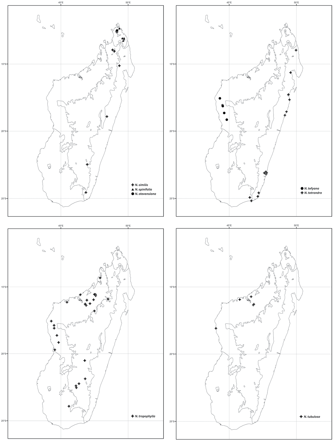
Noronhia tropophylla occurs in low- to mid-elevation dry forests and woodlands from the Sofia region in the northwest to Ihosy in the south ( Fig. 62 View Fig ). It produces flowers and fruits throughout the year except in September.
Conservation status
Noronhia tropophylla is a widespread species occurring at 29 localities scattered from the northwest to the south. With an EOO of 250,483 km 2, an AOO of 112 km 2, and 25 subpopulations representing 22 locations, of which eight occur within protected areas (Ankarafantsika, Baie de Baly, Beanka, Bemaraha, Corridor Bongolava, Menabe-Antanimena, and Sahamalaza-Iles Radama), N. tropophylla is assigned a preliminary status of “Least Concern”.
Notes
Noronhia tropophylla can be recognized by its non-woody petioles, oblong to lanceolate leaf blades often bearing domatia, white, subrotate flowers that lack a corona, and subglobose fruits. It closely resembles N. seyrigii but differs from it by features discussed earlier under that species, mainly flower color and presence/absence of a corona. Noronhia tropophylla exhibits slight variations in the narrowness and texture of the leaf blades that may be linked to different environments. PERRIER DE LA BâTHIE (1949, 1952) used these variations as a basis for recognizing two varieties, which are not adopted here. In any case, the varietal name Linociera tropophylla var. angustata was not validly published because it was not accompanied by a Latin diagnosis (Art. 39.1; MCNEILL et al., 2012). The following syntypes were used as a basis for Noronhia tropophylla: Herb. Jard. Bot. Tan. 6145, Humbert & Swingle 4895, Perrier de la Bâthie 1010, 1725, 1791, 8830, 8831, 8832, 8833, 8834, 12340 and 16564, and Service Forestier 5 and 28, the latter probably a mistake for Service Forestier 8. One of the sheets of Perrier de la Bâthie 12340 at P has been chosen as the lectotype because of its overall completeness and quality. Two collections bearing the same number Perrier de la Bâthie 8830, probably due to a numbering mistake, are recognized respectively as Linociera tropophylla (P [P03559131]!) and Noronhia boinensis (P [P007010251, P04046995]). Similarly, P has two duplicates of Herb. Jard. Bot. Tan. 6145 (P [P03559126, P03559271]), one of which was identified as L. tropophylla (P [P03559126]) and the other as N. seyrigii (P [P03559271]), although the number is cited as L. tropophylla in the protologue ( PERRIER DE LA BâTHIE, 1949). In addition, while the labels indicate Bemaraha (western Madagascar) as the place of collection, Perrier de la Bâthie corrected the locality on the one he identified as N. seyrigii (P [P03559271]), indicating that it was in fact collected at Ampandrandava (southern Mad-agascar): “Localité probablement erronnée – spécimen provenant probablement d’Ampandrandava et des récoltes de Seyrig”. He nevertheless again cited Bemaraha as the place of collection for this number in both the protologue and the “Flore de Madagascar et des Comores ” volume ( PERRIER DE LA BâTHIE, 1949, 1952).
Additional specimens examined
MADAGASCAR. Prov. Fianarantsoa: entre Ambalavao et Ihosy PK 528, [22°23’S 46°07’E], 1. II.1963, Bosser 17535 ( MO, TAN) GoogleMaps ; 35 km S of Ambalavao , 21°52’S 46°48’E, 890 m, 1.IV.1991, Miller & Randrianasolo 6265 ( MO, TAN) GoogleMaps ; Ambalavao , [21°50’S 46°56’E], 11.VIII.1960, Réserves Naturelles 11199 ( MO, P) GoogleMaps . Prov. Mahajanga: Belitsaky, Ankilimanarivo , 17°52’09”S 44°29’14”E, 156 m, 25.X.2009, Andriamihajarivo et al. 1809 ( G, MO, P, TAN, TEF) GoogleMaps ; Beanka, Ambinda-Nord , 18°02’40”S 44°30’07”E, 246 m, 1.XII.2011, Bolliger 44 ( BR, G, K, MO, P, TEF) GoogleMaps ; ibid. loc., 17°56’26”S 44°28’08”E, 172 m, 14. II.2011, Gautier et al. 5592 ( G, K, MO, P, TEF) GoogleMaps ; ibid. loc., Sarodrano , 18°03’01”S 44°31’09”E, 450 m, 5.III.2012, Hanitrarivo et al. 265 ( G, MO) GoogleMaps ; ibid. loc., Andalaposa , 18°00’27”S 44°29’55”E, 291 m, 16.III.2012, Hanitrarivo et al. 345 ( G, MO) GoogleMaps ; ibid. loc., 18°02’42”S 44°30’11”E, 259 m, 27.III.2012, Hanitrarivo et al. 396 ( G, MO) GoogleMaps ; Marovoay, Ampijoroa STF, 16°19’07”S 46°48’13”E, 198 m, 14.III.2009, Hong-Wa 630 ( MO, P, TAN) GoogleMaps ; Tsingy de Bemaraha N of the Manambolo river , 19°09’S 44°49’E, 50 m, 5.XII.1996, Jongkind et al. 3393 ( G, MO, P, WAG) GoogleMaps ; Antsalova, 1 km à l’E d’Ambinda , 18°38’S 44°42’E, 100-200 m, 4.XII.1992, Labat & Deroin 2302 ( MO, P) GoogleMaps ; Port-Bergé, Tsiningia, Marosely , 15°38’58”S 47°35’03”E, 217 m, 16.XI.2004, Ramananjanahary et al. 68 ( G, MO, P, TEF) GoogleMaps ; Mampikony, Betaramahamay, Ambohimanga , 15°57’05”S 47°26’09”E, 232 m, 4.XII.2004, Ramananjanahary et al. 226 ( G, MO, P, TEF) GoogleMaps ; Ambolobozo, Analalava , 14°19’27”S 47°54’36”E, 275 m, 23.VII.1999, Ranaivojaona et al. 241 ( MO, P, TAN) GoogleMaps ; Belobaka, Antsahanitra STF, 15°35’23”S 46°26’00”E, 40 m, 27.XI.2003, Randrianaivo et al. 958 ( CNARP, G, MO, P, TAN) GoogleMaps ; Tsaratanana, Bekapaika, Ambalafary , forêt de Koakala, 16°48’09”S 47°28’58”E, 400 m, 8.XII.2003, Randrianaivo et al. 998 ( CNARP, G, MO, P, TAN) GoogleMaps ; Port Bergé, Bongolava , forêt de Marosely, 15°38’58”S 47°35’03”E, 217 m, 17.XI.2004, Razakamalala et al. 1691 ( MO, P, TEF) GoogleMaps ; ibid. loc., forêt d’Andranomena II, 15°34’00”S 47°29’55”E, 115 m, 28.XI.2004, Razakamalala et al. 1778 ( G, MO, P, TEF) GoogleMaps ; Ampijoroa , [16°18’S 46°49’E], 15.VII.1970, A. Richard 340 ( MO) GoogleMaps ; Maintirano, Ambinda , 18°04’S 44°30’E, 203 m, 19.X.2009, Razakamalala et al. 4450 ( MO, P, TAN) GoogleMaps ; Tsaramandroso, Bevazaha , [Ankarafantsika PN], [16°00’S 46°56’E], 15.X.1947, Réserves Naturelles 1100 ( MO, P) GoogleMaps ; ibid. loc., Lac Tsimaloto , [16°11’S 47°10’E], 80 m, Service Forestier 22 ( P) GoogleMaps ; ibid. loc., Service Forestier 49 ( P) GoogleMaps ; Soalala, Antsakoamileka, forêt Marovitika , [16°08’S 45°27’E], 18.IV.1956, Service Forestier 15917 ( P, TEF) GoogleMaps ; Mandritsara, Andohajango, Ambavaranobe , au bord de la Manambendrana, [16°08’S 48°38’E], 14. V.1966, Service Forestier 25929 ( MO, P) GoogleMaps . Prov. Toliara: Zazafotsy, PK 573, II.1962, Bosser 15822 ( MO, P, TAN) ; Ankirijifotsy, Belo-Tsiribihina , [19°42’S 44°33’E], 27.XI.1953, Service Forestier 7988 ( MO, P) GoogleMaps .

| P |
Museum National d' Histoire Naturelle, Paris (MNHN) - Vascular Plants |
| G |
Conservatoire et Jardin botaniques de la Ville de Genève |
| V |
Royal British Columbia Museum - Herbarium |
| VI |
Mykotektet, National Veterinary Institute |
| MO |
Missouri Botanical Garden |
| TAN |
Parc de Tsimbazaza |
| S |
Department of Botany, Swedish Museum of Natural History |
| TEF |
Centre National de la Recherche Appliquée au Developement Rural |
| BR |
Embrapa Agrobiology Diazothrophic Microbial Culture Collection |
| K |
Royal Botanic Gardens |
| N |
Nanjing University |
| WAG |
Wageningen University |
| A |
Harvard University - Arnold Arboretum |
No known copyright restrictions apply. See Agosti, D., Egloff, W., 2009. Taxonomic information exchange and copyright: the Plazi approach. BMC Research Notes 2009, 2:53 for further explanation.
|
Kingdom |
|
|
Phylum |
|
|
Class |
|
|
Order |
|
|
Family |
|
|
Genus |
Noronhia tropophylla (H. Perrier)
| Hong-Wa, Cynthia 2016 |
Chionanthus tropophyllus (H. Perrier)
| Stearn 1980: 205 |
Linociera tropophylla
| H. Perrier 1949: 280 |
Linociera tropophylla var. angustata
| Hong-Wa & Besnard 2013: 377 |
| H. Perrier 1949: 281 |