
Aegiochus gracilipes ( Hansen, 1895 )
|
publication ID |
https://doi.org/10.11646/zootaxa.4803.2.10 |
|
publication LSID |
lsid:zoobank.org:pub:9B6530A4-DE09-4954-A3A0-F9E31007D18A |
|
persistent identifier |
https://treatment.plazi.org/id/A41EBA59-FFAE-FFC2-FF35-FEFA16F0FCCF |
|
treatment provided by |
Plazi |
|
scientific name |
Aegiochus gracilipes ( Hansen, 1895 ) |
| status |
|
Aegiochus gracilipes ( Hansen, 1895) View in CoL
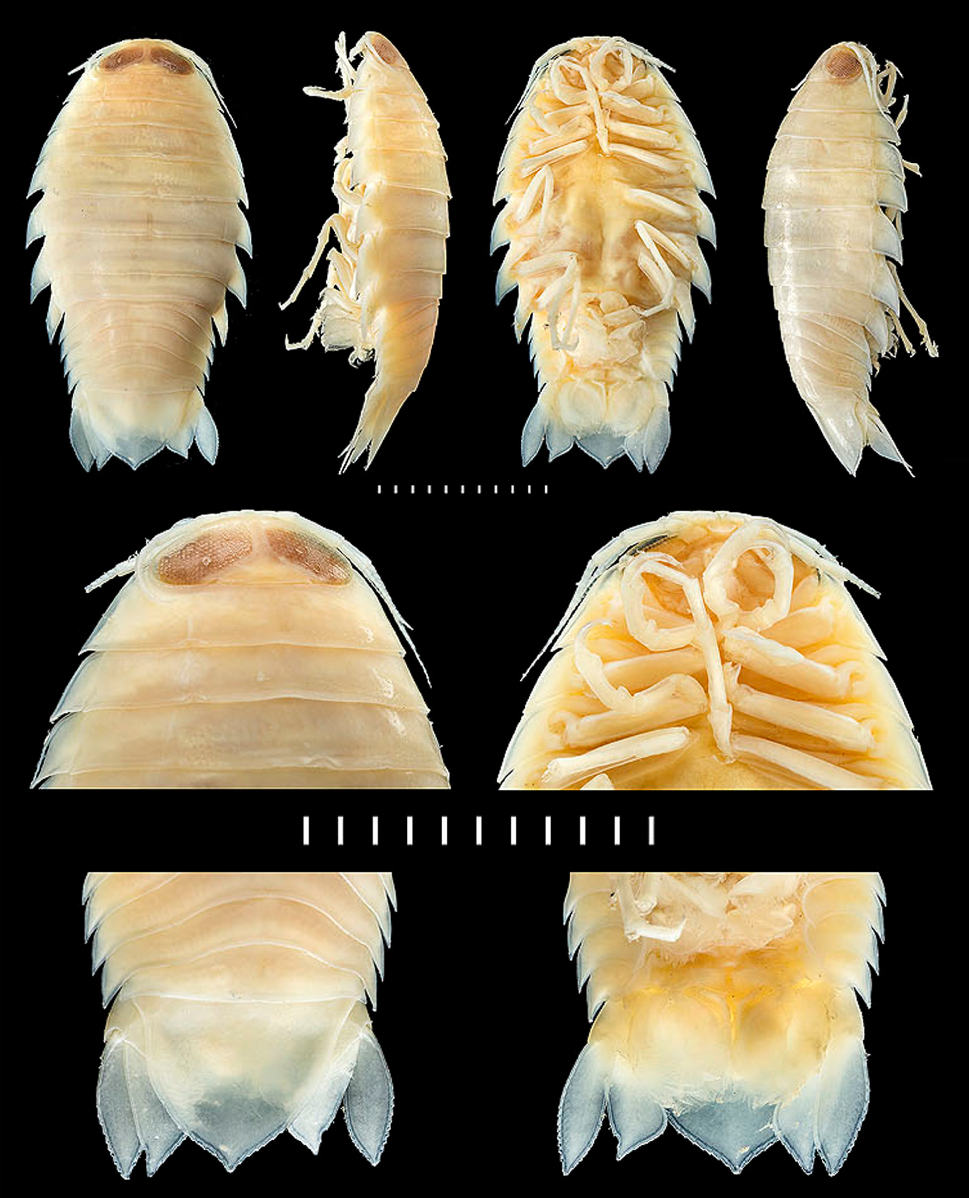
( Fig. 1 View FIGURE 1 )
Aega gracilipes Hansen, 1895: 15 View in CoL , Pl I, figs 6a–c; 1916: 173.— Richardson, 1901: 523; 1905: 183, figs 165, 166.— Nierstrasz,
1931: 184 [list].— Gurjanova, 1932: 85, Pl. XXXII, 132 [repeat records].— Schultz, 1969: 194, fig. 304 [repeat record].—
Kussakin, 1979: 239, fig. 109 [repeat records].— Menzies & Kruczynski, 1983: 40 [list]. Aega (Rhamphion) gracilipes .— Brusca, 1983: 11 [list]. Aegiochus gracilipes .— Bruce, 2009: 213 [list]. Aegiochus tara Bruce, 2009: 146 , figs 88–90, cover photo. New synonymy.
Type locality. Approximately 100 kilometres northwest of the Outer Hebrides, Scotland, United Kingdom, 59.0°N, 08.5°W; depth 1524 metres GoogleMaps .
Material examined. North Eastern Atlantic Ocean. Female, 27.0 mm, non-ovig., NHM UK 2018.1255, Porcupine Seabight & Porcupine Abyssal Plain, 51°19’0”N, 13°5’24”W, 1488–1529 m on label (station list cites 153 m), 1 April 1982, RSS Challenger, station 51419.01, gear OTSB14 ; Female, 26.0 mm, ovig., NHM UK 2018.1256, Porcupine Seabight, 51°8’24”N, 12°1’30”W, 1500–1504 m, 24 March 1972, on label (station list states 9 April 1978), Discovery station 9754.3, BNI.2.4 on label, gear BN1.5/3M; 3 specimens, male, 19.0 mm, female, 24.5 mm, non-ovig, juvenile, 11.0 mm, NHM UK 2018.1258, Porcupine Seabight, 51°8’24”N, 12°1’30”W, depth unknown, 9 April 1978, Discovery station 9754.03, gear BCAM; Female, 27.0 mm, non-ovig., 5 mancas, 7.0, 7.5, 8.0, 9.0, 11 mm, NHM UK 2018.1257, Off North West Africa , 22°35’12”N, 17°37’0”W, 1457–1460 m, 24 July 1972, Discovery Station 8001.02, gear BN2.4/4.5; Male, 17.5 mm, NHM UK 2018.1259, Porcupine Seabight, 49°48’24”N, 14°0’48”W, 3989 m, 10 April 1978, Discovery station 9756.01, gear DN; Male, 18.5 mm, NHM UK 2018.1260, Porcupine Seabight, 49°47’6”N, 14°1’30”W, 454 m, 13 April 1978, Discovery station 9756.09, gear BCAM; Female, 29.5 mm, ovig., NHM UK 2018.1261, Porcupine Seabight, 51°4’24”N, 11°59’18”W, 1533 m, 21 April 1978, Discovery station 9774.01, OTSB14 ; Female, 20.0 mm, non-ovig., NHM UK 2018.1262, Porcupine Seabight & Porcupine Abyssal Plain, 49°24’0”N, 11°45’24”W, 1000– 965 m on label (station list cites 983 m), 8 November 1978 on label ( 8 June 1979 on station list), RSS Challenger station 50522.1, gear OTSB 14 ; 2 females, 22.5, non-ovig., 29.0 mm, ovig., NHM UK 2018.1263, Porcupine Seabight & Porcupine Abyssal Plain, 51°29’24”N, 12°58’48”W, 1493 m, 18 April 1983, RSS Challenger, station 51715.02, gear BN1.5/3M; Female, 23.0 mm, non-ovig., NHM UK 2018.1264, Porcupine Seabight & Porcupine Abyssal Plain, 49°25.40’N 12°49.80’W to 49°26.37’N 12°50.27’W, 1433–1447 m, 26 April 1985 on label (station list cites June), RSS Challenger Station 52218.1, gear BNI.5/ 3m; 3 females, 27.5 mm ovig., 26.5 mm, 22.5 mm, non-ovig, NHM UK 2018.1265, Porcupine Seabight & Porcupine Abyssal Plain, 49°25.40’N, 12°49.80’W to 49°26.37’N, 12°50.27’W, 1433–1447 m, 26 April 1985 on label (station list cites June), RSS Challenger Station 52218.1, gear BNI.5/ 3m; Female , 28.5 mm, ovig., NHM UK 2018.1266, Porcupine Seabight & Porcupine Abyssal Plain, 51°33.3’N 12°48.2’W to 51°33.0’N 12°48.2’W, 30 May 1991, label 1567–1583 m (station list cites depths as 1546–1572), RSS Challenger , station 52703.5, gear OTSB 14 ; 3 specimens, male, 19.7 mm, manca, 12.0 mm, manca, 12.5 mm, NHM UK 2018.1267, Rockall Trough , North Eastern Atlantic Porcupine Seabight , and NW African coast, 49°32’36”N, 13°7’6”W, 1630–1640 m, 9 September 1979, Discovery station 10111.8, gear BN1.5/3N; Male , 17.5 mm, NHM UK 2018.1268, Rockall Trough , North Eastern Atlantic Porcupine Seabight , and NW African coast, 49°32’36”N, 13°7’6”W, 1630–1640 m, 9 September 1979, Discovery station 10111.8, gear BN1.5/3N; 1 juvenile, immature 14.0 mm, NHM UK 2018.1269, off North West Africa , Canary and Cape Verde Isles , 8°59’6”N, 20°16’18”W, 1203 m, 5 March 1972, Discovery station 7822.7, gear BN2.4 on label (station list cites BN2.4/4.5); Female , 25.2 mm ovig, NHM UK 2018.1270, off North West Africa , Canary and Cape Verde Isles, 23°53’0”N, 17°26’54”W, 1500–1504 m, 24 March 1972, Discovery station 7846.01, gear BN2.4/4.5 GoogleMaps .
Western North Atlantic Ocean, Gulf of Mexico. 1 specimen unsexed, USNM 9687 About USNM , South East of Mississippi Delta , Gulf of Mexico, 28.85°N, 88.30°W, 1335 m, 3 March 1885, RV Albatross, station number 2385; Female, 20.0 mm, USNM 9714 About USNM , East of GoogleMaps Mississippi Delta , 28.7917°N, 87.450°W, 1324 m, 13 March 1885, RV Albatross, station 2392; Female, 23.0 mm, USNM 1011317 About USNM , off GoogleMaps Florida, Gulf of Mexico, 29.10°N, 86.588°W, 1170 m, 18 April 1984, RV Gyre, station number E04; Female, 25.0 mm, USNM 1011318 About USNM , off GoogleMaps Florida, 28.0317°N, 86.6683W, 2834–2881 m, 19 April 1984, RV Gyre, station number E05; Female, 22.0 mm, USNM 1011319 About USNM , off GoogleMaps Florida, 28.0317°N, 86.6683°W, 2834–2881 m, 18 April 1984, RV Gyre, station number E04; Female, 20.0 mm, USNM 1011372 About USNM , off GoogleMaps Florida, 28.4417°N, 86.0517°W, 358–375 m, 16 April 1984, RV Gyre, station number E04; Female, 23.0 mm, USMM 1011374 , off GoogleMaps Louisiana, 27.1400°N, 93.3933°W, 792–864 m, 8 April 1984, RV Gyre , station number W03; 1 specimen unsexed, 18 mm, USNM 1416656 About USNM , off GoogleMaps Louisiana, 27.4125°N, 92.6344°W, 1024–1247 m, 8 June 1985, RV Citation , station number WC11; 4 specimens, unsexed, 12 mm, 21 mm, 21 mm, 25 mm, USNM 1416657 About USNM , 9 June 1985, off GoogleMaps Louisiana, 27.5869°N, 92.3778°W, 768–781 m, RV Citation , station number WC11; Female, 21.0 mm, ovig., USNM 1416658 About USNM , 15 June 1984, off GoogleMaps Louisiana, 27.5178°N, 89.8156°W, 1064 m, RV Citation, station number WC11 GoogleMaps .
Remarks. Aegiochus gracilipes is characterised by having: large eyes that are only just separated mesially; a smooth body surface; noticeably slender pereopods, pereopods 1 to 3 with an elongate propodus (i.e. three times as long as maximal width), having a small inferodistal lobe that carries one robust seta; and coxae 5 to 7 being distinctly acute with a concave dorsal margin. For a detailed description see Bruce (2009, figs 88–90).
Although there have been a several citations of Aega gracilipes since Hansen (1916) these works were not based on additional material, but repeats of the older records published in larger guides ( Gurjanova 1932; Kussakin 1979; Schultz 1969) or in lists ( Nierstrasz 1931; Brusca 1983; Menzies & Kruczynki 1983). Richardson (1901, 1905) recorded the species from the Gulf of Mexico, but with no other data, and repeated the record in 1905 using the original drawings of Hansen (1895); those record were regarded as of uncertain identity, but re-examination of both historic and recent material held at the United States National Museum confirm that A. gracilipes is present in the Gulf of Mexico.
Within the family Aegidae there is usually little gross morphological variation between mancas and adults, making the variation illustrated here for Aegiochus gracilipes exceptional for the family. Given that the figure of the manca holotype ( Hansen 1895) has been the only source of identification for the last 120 years, some historical records are still open to question. The distribution is therefore restricted to the present material: the records of Hansen (1895, 1916); Bruce (2009) and the newly examined material herein.
Distribution. Sensu stricto (see remarks above). Eastern North Atlantic; Gulf of Mexico, western North Atlantic; Norfolk Ridge (southwestern Pacific) and off Tasmania, Australia (Tasman Sea). Records are from 906 to 4069 metres depth, though most records are at depths between 1000 and 2000 metres.
| BNI |
Bernhard Nocht Institute for Tropical Medicine |
| RV |
Collection of Leptospira Strains |
No known copyright restrictions apply. See Agosti, D., Egloff, W., 2009. Taxonomic information exchange and copyright: the Plazi approach. BMC Research Notes 2009, 2:53 for further explanation.
|
Kingdom |
|
|
Phylum |
|
|
Class |
|
|
Order |
|
|
Family |
|
|
Genus |
Aegiochus gracilipes ( Hansen, 1895 )
| Hughes, Lauren E., Bruce, Niel L. & Osborn, Karen 2020 |
Aega gracilipes
| Richardson, H. 1905: 183 |
| Richardson, H. 1901: 523 |
| Hansen, H. J. 1895: 15 |