
Heleocoris strabus Montandon
|
publication ID |
https://doi.org/ 10.5281/zenodo.201948 |
|
DOI |
https://doi.org/10.5281/zenodo.6192224 |
|
persistent identifier |
https://treatment.plazi.org/id/A47287FD-C30C-FFE3-60C7-B779BD38F81E |
|
treatment provided by |
Plazi |
|
scientific name |
Heleocoris strabus Montandon |
| status |
|
Heleocoris strabus Montandon View in CoL
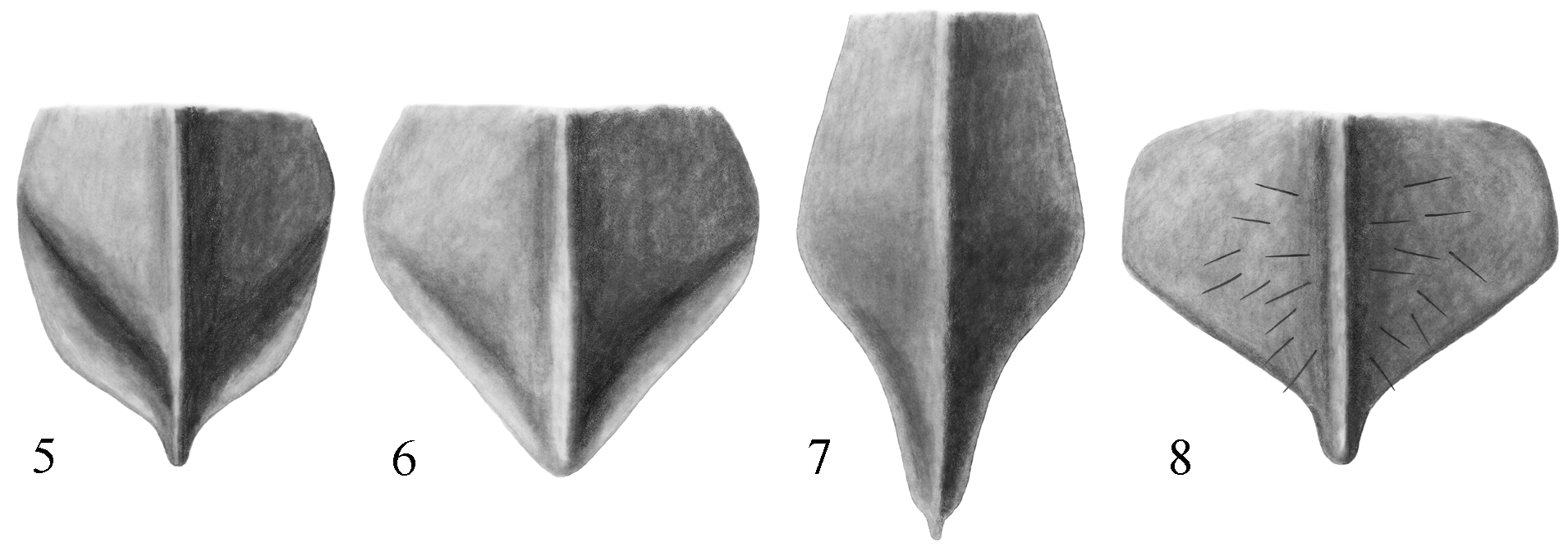
Figs. 3 View FIGURES 1 – 4 , 7 View FIGURES 5 – 8 , 9 View FIGURE 9
Heleocoris strabus Montandon 1897b: 372 View in CoL –373.
Diagnostic information. Males (n=10), length: 10.40–11.20, mean = 10.69; maximum width 7.04–7.84, mean = 7.34. Females (n=10), length: 10.72–11.68, mean = 11.15; maximum width 7.20–7.84, mean = 7.49. This is the largest and most distinctive species of Heleocoris View in CoL in Thailand. It can be distinguished easily from its Thai congeners by the slightly concave lateral margin of the head and the acute posterolateral angles of the pronotum ( Fig. 3 View FIGURES 1 – 4 ). In addition, the metaxyphus is much longer than wide ( Fig. 7 View FIGURES 5 – 8 ) and the lateral margin of the hemelytron is markedly indented at the distal end of the embolium ( Fig. 3 View FIGURES 1 – 4 ). The identity of our specimens was verified by comparison with the holotype, which is housed in the Museo Civico di Storia Naturale - Genoa.
Discussion. Recently, when presenting aquatic Heteroptera records from northeastern Thailand, Chen et al. (2006) expressed the tenuous nature of their identification and assumed correctly their specimens to be H. strabus . The habitus and male genitalia were figured by Chen et al. (2006), and a supplemental description was provided by Distant (1906). Chen et al. (2006) reported the species to be widespread in streams in hilly and mountainous areas of Thailand, which agrees with our observations. Otherwise, no information concerning the biology or ecology of this species has been published. We have collected this species commonly while kick-sampling riffles of clear, shallow streams with a gravel or rock substrate. Frequently, this species was syntopic with H. ovatus and Gestroiella limnocoroides Montandon, and there appears to be a slightly greater affinity for current than we have observed for H. ovatus . We collected this species also with Thurselinus scutellaris (Stål) in a muddy river at Mae Nam Loei and with H. bengalensis montandoni in discontinuous pools of a first-order stream in Nan Province, although these are atypical habitats for H. strabus .
Distribution. In the original description, Montandon (1897b) reported the type locality as Tenasserim, Thagatá. This apparently is Thagata Juwa, a village on the hills southwest of Mt. Mooleyit, Dawna Mountains, in the Tenasserim Valley of Myanmar. This locality is close to Kanchanaburi Province on the western border of Thailand. We have made 122 collections of this common species from throughout much of Thailand ( Fig. 9 View FIGURE 9 ). It has been reported from as far west as the state of Manipur in eastern India ( Thirumalai 2007). We report it from Meghalaya State in northeastern India, east through Myanmar, Thailand, Laos, and Vietnam, and north to Yunnan, China.
Material examined. THAILAND: Chiang Mai Province: creek at Chiang Dao WRC, 19°21'N 98°55'E, 520 m, 18 March 2002, Sites, Vitheepradit & Kirawanich, L-303; same locality, 24 July 2002, CMU team; same locality, 13 Oct. 2002, G. W. Courtney; same locality, 26 May 2002, CMU team; same locality, 25 March 2003, Sites, Vitheepradit & Prommi, L-416; Chiang Dao, Ban Yang Thung Pong, 500 m, 8 Nov. 1995, H. Zettel (10) ( NHMW); W Mae Rim, Mae Sa NP, Mae Sa Falls, 30–31 Oct. 1995, H. Zettel (2) ( NHMW); Amphur Mae Chaem, Mae Pan River, 18°31'N 98°23'E, 540 m, 8 June 2002, CMU team; same locality, 23 Sept. 2002, CMU team; same locality, 3 April 2003, L-444, UMC & CMU teams; same locality, 18°31'N 98°23'E, 540 m, 14 Jan. 2003, CMU team; Doi Inthanon NP, Mae Aep above Hwy 1009, 18°32'N 98°32'E, 630 m, 11 Aug. 2002, CMU team; same locality, 21 Sept. 2002, P. Thansenanupap; same locality, 5 Oct. 2002, CMU team; same locality, 12 Jan. 2003, CMU team; Namtok Huay Sai Luang, 18°31'N 98°27'E, 1060 m, 4 March 2002, CMU team; same data, 11 Aug. 2002; Namtok Mae Klang, 18°29'N 98°40'E, 415 m, 11 Aug. 2002, CMU team; same locality, 4 March 2002, Vitheepradit & Kirawanich, L-260; Namtok Sob Ab, 18°31'N 98°36'E, 4 March 2002, P. Chantaramongkol; same data, N. Changthong; Mae Klang River at Namtok Sob Ab, 18°31'N 98°36'E, 543 m, 5 Oct. 2002, CMU team; same locality, 8 May 2002, UMC & CMU teams, L-397; same locality, 11 Aug. 2002, CMU team; same locality, 13 Nov. 2002, CMU team; Mae Pan Noi at Ban San Pathana, 18°31'N 98°25'E, 750 m, 12 Aug. 2002, bedrock stream, CMU team; same locality, 7 Dec. 2002, CMU team; same locality, 15 March 2003, CMU team; same locality, 4 April 2003, UMC & CMU teams, L-446; Doi Suthep-Pui NP, Huai Kaew above Monthathan, 18°49'N 98°55'E, 800 m, 5 March 2002, G.W. Courtney; same locality, 15 March 2002; same locality, 600 m 5 March 2002; Namtok Monthathan, 18°49'N 98°55'E, 700 m, 9 Aug. 2002, CMU team; same locality, 5 May 2002, L-403; same locality, 8 Oct. 2002; same locality, 11 Jan. 2003; same locality, 12 March 2003; same locality, 18°49'N 98°55'E, 700 m, 11 Dec. 2002, CMU team; same locality, 15 Feb. 2003, CMU team; same locality, 29 March 2003, UMC & CMU teams, L- 427; Monthantarn Falls, 24 March 1994, W. D. Shephard; same locality, 2 Nov. 1995, 750– 800 m, H. Zettel (4) ( NHMW); same locality, 700–750 m, 6 Nov. 1995, H. Zettel (8) ( NHMW); Pa Ngerb, 18°48'N 98°56'E, 530 m, 5 April 2002, UMC & CMU teams, stream, L-325; same locality, 9 August 2002, CMU team; same locality, 15 Nov. 2002; same locality, 9 July 2002; same locality, 8 Oct. 2002; same locality, 10 Dec. 2002; same locality, 11 Jan. 2003; nr. Ruesee Cave, 900–1000 m, 5 Nov. 1995, H. Zettel (7) ( NHMW); nr. Wat Doi Suthep, 900 m, 1 Nov. 1995, H. Zettel (3) ( NHMW); Namtok Mohk Fah, 19°06'N 98°46'E, 600 m, 13 Oct. 2002, CMU team; creek from Namtok Mohk Fah, 19°06'N 98°46'E, 564 m, 25 March 2003, Sites, Vitheepradit & Prommi, L-415; Namtok Sai Yoi, 18°48'N 98°55'E, 1100 m, 5 April 2002, UMC & CMU teams, L-326; same locality, 5 May 2002, L-402, CMU team; Wang Bua Boon, 24 March 1994, W. D. Shepard. Chiang Rai Province: Doi Luang NP, Namtok Poo Kaeng, 19°26'N 99°42'E, 540 m, 27 Dec. 2002, CMU team. Chumphon Province: Khun Mae Yam Oum WS, Namtok Chum Poon, 0 9°47.579'N 98°54.257'E, 100 m, 30 May 2004, Vitheepradit & Prommi, L-731; same locality, 20 June 2006, L-965. Kamphaeng Phet Province: Khlong Lan NP, stream at Namtok Khlong Lan, 16°07'N 99°16'E, 8 March 2002, Vitheepradit, Kirawanich & Sites, L-272; same locality, 20 October 2002; Namtok Phetcha Khor, 16°17'N 99°14'E, 7 April 2003, Sites, Vitheepradit, Prommi & Setaphan, L-452. Kanchanaburi Province: Amphur Sai Yok, Thong Pha Phum FRS, Mae Nam Noi, 14°31'N 98°37'E, 204 m, 10 April 2003, UMC & CMU teams, L-462; Amphur Sangkhla Buri, Huay Li Jia, 15°04'N 98°33'E, 169 m, 26 May 2004, Vitheepradit & Prommi, L-718; Amphur Thong Pha Phum, Huay Ka Yaeng at Ban Pa Jam Mai, 14°35'N 98°34'E, 247 m, 9 April 2003, Sites, Vitheepradit, Prommi & Setaphan stream, L-458; Amphur Thong Pha Phum, Huay Ka Yaeng at Ban Padsadoo Klang, 14°33.364'N 98°34.335'E, 296 m, 4 June 2006, Sites, Vitheepradit & Prommi, L-915; Amphur Thong Pha Phum, Huay Ou Long, 14°46'N 98°40'E, 139 m, 12 May 2003, Vitheepradit, Prommi & Ferro, stream, L-525; same locality, 5 June 2006, 14°46.933'N 98°40.258'E, Sites, Vitheepradit & Prommi, L-919; Huai Than Ngun, 14°39'N 99°18'E, ca. 700 ft, 30 Oct. 1994, G.W. Courtney; Thong Pha Phum, stream at Huay Ka Yaeng, 24 Sept. 2002, T.O. Prommi. Krabi Province: Khao Phanom Bencha NP, Namtok Huay To, 08º14.321'N 98º54.897'E, 26 m, 11 June 2004, Sites, Vitheepradit & Prommi, L-759; same locality, 6 April 2005, T.O. Prommi. Lampang Province: Jae Sawn NP, Namtok Jae Sawn, 18°50'N 99°28'E, 650 m, 16 March 2002, Sites, Vitheepradit, Kirawanich, L-297. Loei Province: Ma Nam Loei at Ban Huay, Nam Une, 11 June 1998, Sites, Simpson & Vitheepradit, muddy river w/ gravel & veg., L-180; Namtok Phah Paw, Huay Kang Station of Phu Luang WS, 11 June 1998, Sites, Simpson & Vitheepradit, tiny waterfall trickle, L-181; Na Haew NP, Namtok Wahng Tahd, 17°28'N 100°57'E, 750 m, 9 March 2002, Vitheepradit, Kirawanich & Sites, L-277; same locality, 22 Oct. 2002, CMU team; 1 km N Wang Kum, unnamed stream, 9 March 1994, W.D. Shepard, WDS-A-1036. Mae Hong Son Province: Namtok Maw Pang, 19°22'N 98°22'E, 850 m, 19 March 2002, Sites, Vitheepradit & Kirawanich L-305; same locality, 14 Oct. 2002, Huay Mae Saket, just S Mae Hong Son, 19°14'N 97°58'E, 280 m, 20 March 2002, CMU team; Pha Bong, 12 km S Mae Hong Son, 12 Nov. 1995, H. Zettel (13a) ( NHMW); 3 km SE Mae Hong Son, 13 Nov. 1995, H. Zettel (14a) ( NHMW); ca. 25 km N of Mae Hong Son, Ban Na Pla Chia at Mae Nam, Sangel River, N 019°30'31.0" E 098°00'05.7", 9 Aug. 1997, W. Ullrich (WUC). Nakhon Si Thammarat Province: Namtok Yong NP, Namtok Yong, 117 m, 0 8°10'N 99°44'E, 6 April 2004, stream, T.O. Prommi; Namtok Karom, 7 April 2005, T.O. Prommi. Nan Province: Amphur Bo Kluea, Tumbon Phuka, Doi Phuka Park Ranger Station 6, Huay Korg, 19°01'N 101°11'E, 516 m, 22 April 2003, Vitheepradit, Prommi & Setaphan, stream, L-474; Doi Phuka NP, Namtok Ton Tong, 19°12'N 101°04'E, 900 m, 13 March 2002, Sites, Vitheepradit & Kirawanich, L-291; Mae Charim NP, Nam Wa River, 18°36'N 100°59'E, 335 m, 23 April 2003, Vitheepradit, Prommi & Setaphan, L-478; Namtok Tak Man, 19°17'N 100°47'E, 352 m, 21 April 2003, Vitheepradit, Prommi & Setaphan, L-471. Petchabun Province: Nam Nao NP, Prom Laeng, 22 March 1994, W.D. Shepard, WDS-A-1040; Phu Khieo WS, Nam Prom, 4 April 1994, W.D. Shepard, WDS-A-1053. Phang Nga Province: Khao Lampi-Hat Thai Mueang NP, Namtok Lam Pi, 08º27.862'N 98º16.880'E, 51 m, 12 June 2004, Sites, Vitheepradit & Prommi, L-762; Namtok Tone Prai, 08º26.192'N 98º18.550'E, 63 m, 12 June 2004, Sites, Vitheepradit & Prommi, L-761; same locality, 92 m, 29 May 2003, Vitheepradit & Ferro, L-577; Sri Phang Nga NP, 3 April 2005, stream, T. O. Prommi. Phayao Province: Doi Luang NP, Namtok Cham Pa Thong, 19°13'N 99°44'E, 620 m, 17 March 2002, Sites, Vitheepradit & Kirawanich, L-300; same locality, 23 June 2002, CMU team, L-678; same locality, 23 July 2002, CMU team; same locality, 24 September 2002, CMU team; same locality, 27 March 2003, Sites, Vitheepradit & Prommi, L-420; Huay Chom Poo WS, Huay Chom Poo Falls, 19°10'N 100°06'E, 526 m, 20 April 2003, Vitheepradit, Prommi & Setaphan, L- 468. Phitsanulok Province: Phu Hin Rongkla NP, Namtok Palad, 16°59'N 101°00'E, 300 m, 12 March 2002, Sites, Vitheepradit & Kirawanich, L-289. Phrae Province: Wieng Ko Sai NP, Namtok Maekueng Luang, 17°58'N 99°35'E, 350 m, 14 March 2002, Sites, Vitheepradit & Kirawanich, L-295; Namtok Maekueng, tier 1, 17°58'N 99°35'E, 400 m, 22 March 2003, CMU team; same locality, 29 Sept. 2002; Namtok Maekueng, tier 7, 17°58'N 99°35'E, 430 m, 24 May 2002, CMU team; same data, 19 Dec. 2002; Namtok Punjane (lower), 17°56'N 99°34'E, 270 m, 22 June 2002, CMU team; same data, 22 March 2003; same data, 29 Sept. 2002; same locality, 285 m, 21 Feb. 2003; same locality, 295 m, 22 July 2002; same data, 26 Oct. 2002; Namtok Punjane (upper), 17°57'N 99°34'E, 295 m, CMU team; same data, 23 May 2002; same data, 22 July 2002; same data, 24 Aug. 2002; same data, 20 December 2002; Namtok Punjane, 17°56'N 99°34'E, 430 m, 28 March 2003, Sites, Vitheepradit & Prommi, L-424; same locality, 24 April 2002, A. Nuntakwang; 50 km NE Pharae, 5 km SE Huai Kaet, 18 Nov. 1995, H. Zettel (18a) ( NHMW). Ratchaburi Province: Amphur Suan Phueng, Namtok Huay Nam Sai, 13°35'N 99°12'E, 204 m, 14 May 2003, Vitheepradit, Prommi & Ferro, L-531; Amphur Suan Phueng, Namtok Kao Chan, 13°31'N 99°14'E, 159 m, 17 April 2002, Vitheepradit & Kirawanich, L-349; same locality, 14 May 2003, Vitheepradit, Prommi & Ferro, L-530. Suratthani Province: Amphur Phanom, Namtok Ton Yai, 08°40'N 98°41'E, 67 m, 28 May 2003, Vitheepradit & Ferro, L-574; Khao Sok NP, Namtok Sipet Chan, 6 Aug. 2004, T.O. Prommi; same locality, 4 April 2005; Namtok Dard Fah, 10 April 2005, T.O. Prommi; Namtok Sunantha, 8 April 2005, T.O. Prommi. Tak Province: Amphur Tha Song Yang, stream 27.3 km NW of Tha Song Yang on Hwy 105,17º34.367'N 97º57.192'E, 169 m, 21 April 2009, Sites, Vitheepradit & Prommi, L-1054. Uttaradit Province: Khlong Tron NP, Namtok Khlong Tron, 17°36'N 100°44'E, 662 m, 26 April 2003, Vitheepradit, Prommi & Setaphan, L-486; Namtok Mae Cheuy, 17°47'N 100°10'E, 231 m, 27 April 2003, Vitheepradit, Prommi & Setaphan, L-487.
Additional material examined. CHINA: Yunnan Province, Mengla, Men-E stream, 11 July 2001, H.M. Liu, ME4-009F; Xishuangbanna Dai Autonomous Prefecture, Mengla County, Menglun Town, near Mangmo Village, road Menglun–Ganlanba, ca. 15 km W Menglun, ca. 700–800 m, stream (left hand side tributary of CWBS loc. 355), 5 Nov. 1999; M.A. Jäch, H. Schönmann, M. Wang & Y. Wei ( NHMW); same Prefecture, Menghai County, pass (near summit) on old road Jinghong–Mengyang, ca. 1100 m, 12 Nov. 1999, M.A. Jäch, H. Schönmann, M. Wang & Y. Wei. INDIA: Meghalaya State, West Garo Hills, reg., Tura, N 25°30.7' E 90°13.9', 600–800 m, 5–7 June 1996, E. Jendek & O. Sausa ( NHMW); LAOS: Luang Nam Tha Province, 20 km SE Muang Sing, 12.6.1996 950 m, Schillhammer (25) ( NHMW). MYANMAR: HOLOTYPE, Tenasserim, Thagata, Fea. Apr. 1887 ( MCSN); Sagaing Division, Alaungdaw Katthapa NP, Pagoda Stream, 22°18.560'N 94°27.679' E, 400 m, 6 May 2003, Boukal & al. (111) ( NHMW); same stream, 22° 19.084' N 94° 28.744' E, 360 m, 7 May 2003, Boukal & al. (113) ( NHMW); same stream, 22° 19.094' N 94° 28.823' E, 350 m, 9 May 2003, Boukal & al (118) ( NHMW); same stream, 22° 19.113' N 94° 28.518' E, 350 m, 13 May 2003, Boukal & al (122) ( NHMW); same locality, Khaung Din Stream, 22° 18.360' N 94° 25.937' E, 450 m, 11 May 2003, Boukal & al (119) ( NHMW); same locality, Wakya Stream, 22° 19.173' N 94° 29.654' E, 400 m, 8 May 2003, Boukal & al. (115) ( NHMW). THAILAND / LAOS: Loei Province, Na Haew NP, Tahd Heuang International Waterfall, 17°33'N 100°59'E, 500 m, 10 March 2002, Sites, Vitheepradit & Kirawanich, L-280. VIETNAM: (S. VIETNAM), 12 km N Dalat-LangBian 28–30 April 1994, P. Pacholátlo & L. Dembicky ( NHMW); 40 km NW An Khe, Buon Luoi, 14°10'N 108°30'E, 28 March–12 April 1995, 620– 750 m, Pacholátlo & Dembicky ( NHMW).


No known copyright restrictions apply. See Agosti, D., Egloff, W., 2009. Taxonomic information exchange and copyright: the Plazi approach. BMC Research Notes 2009, 2:53 for further explanation.
|
Kingdom |
|
|
Phylum |
|
|
Class |
|
|
Order |
|
|
Family |
|
|
Genus |
Heleocoris strabus Montandon
| Sites, Robert W. & Vitheepradit, Akekawat 2011 |
Heleocoris strabus
| Montandon 1897: 372 |