
Solanum agrimonifolium, Rydb.
|
publication ID |
https://doi.org/ 10.1043/0363-6445-26.4.743 |
|
DOI |
https://doi.org/10.5281/zenodo.6343248 |
|
persistent identifier |
https://treatment.plazi.org/id/B5380619-FF8D-8D33-FF58-F5B65A91D717 |
|
treatment provided by |
Jonas |
|
scientific name |
Solanum agrimonifolium |
| status |
|
SOLANUM AGRIMONIFOLIUM Rydb. View in CoL , Bull. Torrey Bot. Club 51: 154. 1924.
—TYPE: MEXICO. Chiapas: Cerro del Boquerón , Sep 1913, Purpus 6977 (holotype: US!, [photo: K!, PTIS!] ; isotypes: BM!, F! [photo: PTIS!], GH! [photos: K!, F!, PTIS!], MO! [photo: PTIS!], NY [2!] [photos: LL!, PTIS!]) .
Plants 0.5–2 m tall; finely pubescent above and below, blades 13–30 cm long, 10–19 cm wide, petioles 1– 5 cm long; lateral leaflets (3)5–7(8) pairs, sessile to subsessile with petiolules to 2 mm long; interjected leaflets 4–31; inflorescence with 8–38 flowers; calyx lobes 3–8 mm long, long attenuate; corolla 2–3 cm diam, bluish purple to purple; fruits 2–5 cm long.
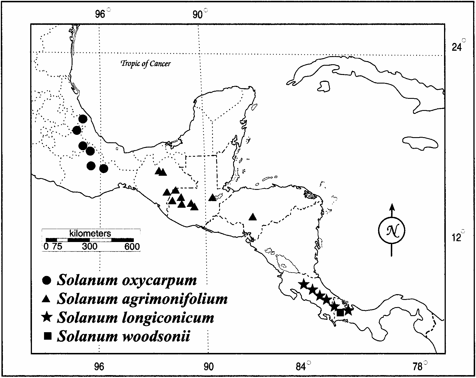
Distribution and Habitat ( Fig. 2 View FIG ). Southern Mexico (Chiapas), southeast through Guatemala and central Honduras, 1600–3800 m; in wet habitats, in organic soils, in full sun to partial shade, often in cloud forests. Common habitats include recently logged or otherwise recently disturbed areas in valleys, streamsides, upland marshes, or roadside ditches.
Additional Specimens Examined (germplasm collections at NRSP-6 from Mexico are denoted by an asterisk; see Spooner et al. [1998] for specimens from Guatemala and Honduras) . MEXICO. Chiapas: steep slopes on SE side of Zontehuitz near summit, Municipality of Chamula, 9400 ft, 31 Jul 1964, Breedlove 6696 ( CAS, LL, MEXU) ; steep heavily wooded northeast slope of Zontehuitz near summit, Municipality of San Cristóbal las Casas, 9300 ft, 20 Jul 1965 Breedlove 11137 ( CAS, F, LL) ; steep northeast slope of Zontehuitz near summit, Municipality of San Cristóbal las Casas, 21 Sep 1965, Breedlove 12343 ( CAS, MEXU, F, LL) ; steep canyon, SW side of Cerro Mozotal, 11 km NW of the junction of the road to Motozintla along the road to El Porvenir and Siltepec, Municipality of Motozintla de Mendoza, 2100 m, Breedlove 25761 ( CAS) ; high ridge near Niquivil at the junction with a small side ridge to Cerro Boquerón, Municipality of Motozintla de Mendoza, 2600 m, 16 Dec 1976, Breedlove 42787 ( CAS) ; Barrio Emiliano Zapata, high mountains between Huixtla and Motozintla, 2180 m, 9 Jul 1966, Flores C. S-948 ( MEXU) ; Cerro Zontehuitz, almost at the top by the microwave station, 2800 m, 9 Jul 1966, Flores C. S-952 ( MEXU) ; San Cristóbal Las Casas, Cerro Zontehuitz, on path to Los Ángeles, at the highest point, 2900 m, 13 Jul 1949, Hawkes et al. 1019 ( B, K, LL, P) ; Fraylesca, near Siltepec, 2000 m, 12 Mar 1945, Matuda 5246 ( F, LL, MEXU, NA) ; Amatenango del Valle, 1835 m, 13 Jun 1945, Matuda 30161 ( MEXU) ; Cerro Huitepec, W of San Cristóbal, Municipality of Zinacantán, 17 Jul 1985, Méndez G. 8353 ( MO) ; Montana Alcoliades, route from Motozintla to Porvenir, Las Silvas, 2830 m, 14 Sep 1980, Ochoa 14147 ( US) ; Cerro Zontehuitz, 9.7 km up microwave tower road, turning off the San Cristóbal de las Casas to Tenejapa road, 16°48.87̍N, 92°34.96̍W, 2800 m, 10 Oct 1997, Rivera-Peña et al. 959 (INIFAP, MEXU, PTIS, WAG)* ; 50 m walk downhill from the uppermost antenna cluster on Cerro Zontehuitz, by the lower of the two shrines, 16°49.10̍N, 92°34.82̍W, 2950 m, 10 Oct 1997, Rivera-Peña et al. 960 (INIFAP, MEXU, PTIS, WAG)* ; 17.4 km N of Rt 190 just S of Motozintla on road to El Porvenir, ca 50 m W of road, 15°24.22̍N, 92°10.72̍W, 2410 m, 11 Oct 1997, Rivera-Peña et al. 961 (INIFAP, MEXU, PTIS, WAG)* ; 1.2 km N of town square of El Porvenir, on road to Siltepec, ca 100 m W of road, 15°27.96̍N, 92°16.84̍W, 2850 m, 11 Oct 1997, Rivera-Peña et al. 963 (INIFAP) ; Cerro Boquerón, Sep 1913, Rydberg s. n. ( NY, F, GH, MO, US) ; 6.9 km N of Route 190 beginning S of Motozintla de Mendoza on road to Siltepec, in woods on W side of road, in Ejido Benito Juárez, 15°22̍N, 92°17̍W, 2005 m, 25 Sep 1988, Spooner et al. 4208 ( IBUG, INIFAP, PTIS)* ; Cerro del Boquerón at Barrio Pizarrin, in woods, on W side of road, 17.4 km N of Route 190 of Motozintla de Mendoza on road to Siltepec, 15°25̍N, 92°18̍W, 2330 m, 25 Sep 1988, Spooner et al. 4211 (INIFAP, PTIS, WIS)* ; 12.1 km along road to microwave tower of Zontehuitz, from San Cristóbal de las Casas-Tenejapa road, 0.1 km downhill from microwave tower, along roadside, 16°20̍N, 92°17̍W, 2790 m, 30 Sep 1988, Spooner et al. 4227 ( IBUG, INIFAP, PTIS, WIS)* ; road from San Cristóbal de las Casas to Cerro Zontehuitz, 9.7 km along road to microwave tower, turning off the road to Tenejapa, 16°49̍N, 92°35̍W, 2750 m, 21 Oct 1984, Tarn et al. 277 ( PTIS)* ; road from San Cristóbal de las Casas to Cerro Zontehuitz, 9.8 km along road to microwave tower, turning off road to Tenejapa, 16°49̍N, 92°35̍W, 2760 m, 21 Oct 1984, Tarn et al. 278 ( K [cult.], PTIS)* ; road from San Cristóbal de las Casas to Cerro Zontehuitz, about 10 km along road to microwave tower, turning off the road to Tenejapa, 16°48̍N, 92°35̍W, 2760 m, 23 Oct 1984, Tarn et al. 280 ( PTIS)* .
| CAS |
USA, California, San Francisco, California Academy of Sciences |
| MEXU |
MEXU |
| PTIS |
PTIS |
| WAG |
WAG |
| IBUG |
IBUG |
| WIS |
WIS |
No known copyright restrictions apply. See Agosti, D., Egloff, W., 2009. Taxonomic information exchange and copyright: the Plazi approach. BMC Research Notes 2009, 2:53 for further explanation.