
Solanum oxycarpum, Scheide
|
publication ID |
https://doi.org/ 10.1043/0363-6445-26.4.743 |
|
DOI |
https://doi.org/10.5281/zenodo.6343252 |
|
persistent identifier |
https://treatment.plazi.org/id/B5380619-FF8E-8D32-FC9A-F4465BF9D01B |
|
treatment provided by |
Jonas |
|
scientific name |
Solanum oxycarpum |
| status |
|
SOLANUM OXYCARPUM Scheide View in CoL in Schltdl., Hort. hal. 1: 5, tab 3. 1841.
–TYPE: MEXICO. Veracruz: in rocky places at Malpays de La Joya , Jun 1929, C. Schiede s. n. (lectotype, chosen by Hawkes [1957]: HAL, [photos: K!, PTIS!) .
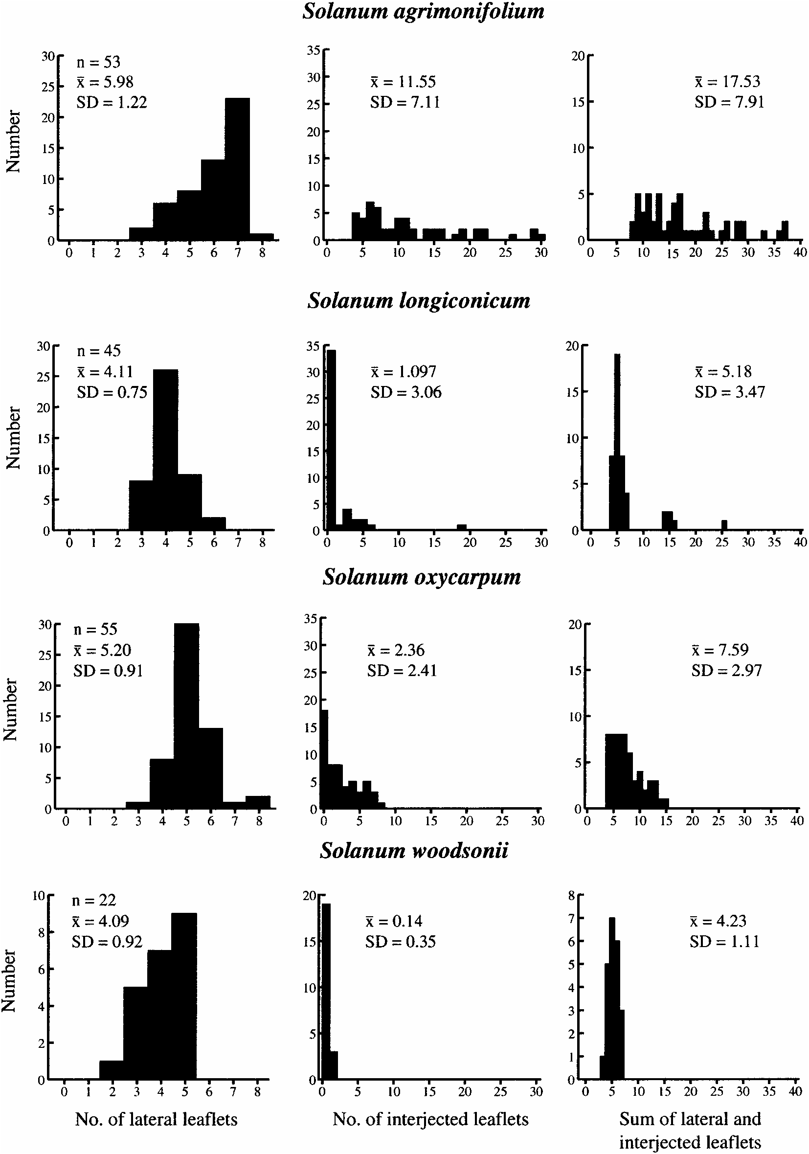
Plants 0.3–2 m tall; finely to coarsely pubescent above and below, blades 13–25 cm long, 7–15 cm wide, petioles 0.5–5 cm long; lateral leaflets (3)4–6(8) pairs, sessile to subsessile with petiolules to 3 mm long; interjected leaflets 0–8; inflorescence with 8–25 flowers; calyx lobes 3–7 mm long, acute to long-attenuate; corolla 2–3 cm in diam, purple; fruits 2–3.5 cm long.
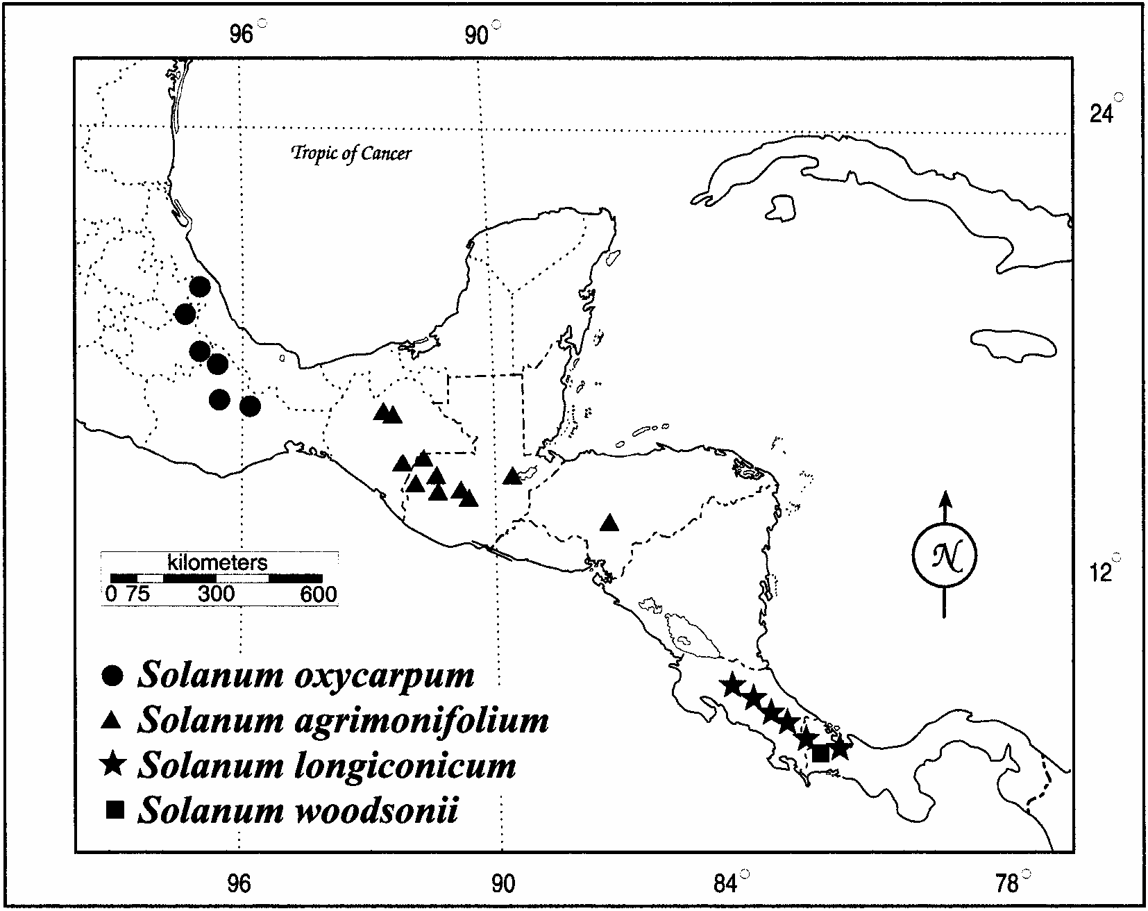
Distribution and Habitat ( Fig. 2 View FIG ). Southeastern Mexico (Hidalgo, Oaxaca, Puebla, Veracruz); from 1870–2870 m; in wet habitats, in organic soils, in full sun to partial shade, growing among shrubs and in pine-oak-alder forests, frequently in pockets of volcanic rocks, often growing among ferns and mosses.
Additional Specimens Examined. MEXICO. Hidalgo: mountains NE of Ixtlán de Juárez on road to Tuxtepec, 20-Jul 1968, Anderson & Anderson 4850 ( ENCB) ; Municipality of Tenango de Doria, 11 km W of Tenango de Doria, 2100 m, 6 Jul 1979, Hernandez M. 3427 ( MEXU) ; 20 km E of Metepec, Municipality of Metepec, 2130 m, 11 Aug 1980, Hernandez M. and Hernandez V. 4772 ( CAS, ENCB, MEXU) ; on Metepec-Tenango de Doria Rd, 16 km NE of intersection of this road with road entering Metepec, on S side of road, 20°18.94̍N, 98°15.50̍W, 2280 m, 4 Oct 1997, Rivera-Peña et al. 944 (INIFAP, MEXU, PTIS, WAG)* . Oaxaca: Km 25 on the road to Teotitlán from Huautla, right side of a canyon, 8 Nov 1964, Flores C. S-797 ( K, LL) ; Yotao, Galeotti 1225P ( W) ; in Sierra Madre Oriental, 29 km E of Teotitlán, 2300 m, 25 Sep 1957, Graham 323 ( LL) ; District of Mixe, Municipality of Totontepec, Totontepec, 17°15̍N, 96°02̍W, 2 Nov 1989, Rivera R. 1245 ( MEXU) ; Km 25 on the road from Teotitlán to Huatla, ca 20 m S of road above stream, 18°10.52̍N, 97°00.36̍W, 2240 m, 4 Oct 1997, Rivera-Peña et al. 952 (INIFAP, MEXU, PTIS, WAG)* ; Km 27.2 on road from Teotitlán to Huatla, at Puerto Soledad, 18°09.95̍N, 96°59.87̍W, 2370 m, 4 Oct 1997, Rivera-Peña et al. 953 (INIFAP, MEXU)* ; District Mixe, Municipality of Totontepec, Totontepec, 17°15̍N, 96°00̍W, 1900 m, 6 Oct 1986, Reyes 484 ( K, MEXU) ; 21.8 km N of Ixtlán de Juárez on Hwy 175 to Tuxtepec, 17°28̍N, 96°30̍W, 2870 m, 17 Oct 1984, Tarn et al. 272 ( PTIS)* ; same locality, 22 Sep 1988, Spooner et al. 4200 (INIFAP, IBUG, PTIS) ; 27 km N of N end of Ixtlán de Juárez on Rt 175 to Tuxtepec, 17°31̍N, 96°31̍W, 2850 m, 22 Sep 1988, Spooner et al. 4202 ( INIFAP, PTIS) ; 8.5 m E. of Rt 135 on road to Huautla, 18 Oct 1981, Warnock 2506 ( TEX) . Puebla: from Tehuacan to Puebla Rd., turn NE on road to Zoquitlán, 22 km up road, by divergence of road to Coyomeapa, 18°17.84̍N, 97°03.96̍W, 2640 m, 4 Oct 1997, Rivera-Peña et al. 951 (INIFAP, MEXU, PTIS, WAG)* ; road from Tehuacan to Oaxaca, turning off at Coxcatlán, 21 km towards Zoquitlan, La Griega, where road divides to Zoquitlan and Coyomeapa, 20°40̍N, 100°14̍W, 2660 m, 24 Oct 1987, Tarn et al. 180 ( PTIS)* ; road from Tehuacán to Oaxaca turning off at Coxcatlán towards Zoquitlan, 22 km along this road, 1 km past La Griega towards Coyomeapa , 20°40̍N, 100°14W, 2640 m, 24 Oct 1983, Tarn et al. 182 ( K, PTIS)* . Veracruz: Perote, La Joya, 1950 m, 23 Sep 1938, Balls and Gourlay 5513 ( BM, K) ; La Joya, Jalapa to Perote Rd, Rafael Ramírez, 2100 m, 29 Aug 1972, Dorantes et al. 1618 ( CAS, ENCB, F, MEXU, TAES, TEX) ; La Joya Mexico to Veracruz to Jalapa Rd, 100 m on right side of rd, 30 Sep 1964, Flores C. S-792 ( K, LL, MEXU) ; pedregal de La Joya, 18°14̍N, 96°07̍W, 2000 m, 27 Aug 1953, Graham 1 ( PTIS)* ; upper outskirts of La Joya, 2080 m, 12 Aug 1949, Hawkes and Hernández 1064 ( B, K, LL, MEXU, MPU, P, WAG) ; near Perote, km 306.5 from Mexico, road from Las Vigas to Jalapa, upper edge of La Joya village, Milpais de la Joya, walled enclosure on the S side of the road, 19°34̍N, 97°14̍W, 2100 m, 8 Oct 1958, Hawkes et al. 1634 ( PTIS) ; near Perote on the road from Las Vigas to Jalapa, upper edge of La Joya village, Milpais de La Joya, 2100 m, 8 Oct 1958, Hawkes et al. 1643 ( K)* ; near Perote, road from Las Vigas to Jalapa, upper edge of the La Joya village, Malpais de La Joya, 19°34̍N, 97°14̍W, 2100 m, 8 Oct 1958, Hawkes et al. 1645 ( C, K, MPU, PTIS, US)* ; Km 305.5 from Mexico on the road from Las Vigas to Jalapa, Malpais de La Joya, 19°40̍N, 98°35̍W, 2150 m, 8 Oct 1958, Hawkes et al. 1649 ( C, K, P, PTIS)* ; Municipality of Acajete, along road, Rt 140, 1 km NW of La Joya, 19°37̍N, 97°02̍W, 2175 m, 7 Sep 1986, Nee 32990 ( NY) ; old lava field about 4 mi W of Jalapa, 5000 ft, 28 Aug 1970, Norris & Taranto 16840 ( CAS, MEXU) ; La Joya, route from Jalapa to Puebla, near Perote, 2050 m, 10 Oct 1980, Ochoa 14213 ( PTIS, US)* ; La Joya, along Perote to Jalapa road, ca 100 m S of road by the restaurants by the road, 19°36̍.74̍N, 97°, 2188 m, 2 Oct 1997, Rivera-Peña et al. 949 (INIFAP, MEXU, PTIS, WAG)* ; Malpais de La Joya between Perote and Jalapa, about 32 km from Perote, Km 176 on Rt 140, 19°37̍N, 97°02̍W, 2200 m, 1 Nov 1984, Tarn et al. 286 ( PTIS)* ; Malpais de La Joya between Perote and Jalapa, about 32 km from Perote, Km 176 on Rt 140, 19°37̍N, 97°02̍W, 2200 m, 1 Nov 1984, Tarn et al. 287 ( PTIS)* ; turning off Rt 140 between Perote and Las Vigas, go S from Sierra de Agua ( N slope of Cerro Cofre de Perote); 14 km above Pescados, Rajas, 19°33̍N, 97°10̍W, 2840 m, 2 Nov 1984, Tarn et al. 288 ( PTIS)* ; Llano Grande, Municipality of Las Vigas, 2115 m, 15 Jul 1971, Ventura A. 3868 ( ENCB, IEB, MEXU) ; La Joya, Municipality of Acajete, 2050 m, 12 Jul 1980, Ventura A. 17479 ( ENCB, IEB, MEXU) ; Piedra Blanca, Municipality of Las Vigas, 2250 m, 13 Jul 1982, Ventura A. 19639 ( ENCB, IEB, MEXU) ; Along Xalapa to Vigas Rd, 200 m E of the road, at the altitude of Toxtlacoaya, Municipality of Las Vigas, 19°37̍N, 97°03̍W, 2200 m, 30 Aug 1989, Zamora C. 1009 ( IEB, MEXU) . Locality unknown: Liebmann 1394, 1841–1843 ( C [photo K]) .
Spooner et al. (2000) noted overlap in numbers of lateral and interjected leaflets in the field in Mexico between S. agrimonifolium and S. oxycarpum , which led them to question the distinctness of these two species. A collection from Hidalgo (Rivera-Peña et al. 944) from within the geographic range of S. oxycarpum was especially problematical because of its many lateral and interjected leaflets, this resembling some populations of S. agrimonifolium . Our data from three herbarium specimens of this collection ( Table 2 View TABLE ) show numbers of lateral and interjected leaflets of (8,4; 7,6; 8,7), with the latter counts (specimen at WAG) having the highest numbers of leaflets for S. oxycarpum . However, other specimens from outside the range of S. agrimonifolium are nearly as dissected (e.g., Rivera 1245 [MEXU], from Oaxaca with 6,8). Collection Rivera-Peña et al. 944 is on the high end of variation for dissection for S. oxycarpum ( Fig. 3 View FIG ). The RAPD data show it to cluster with other accessions of this species, leading us to recognize it as S. oxycarpum .
| HAL |
HAL |
| ENCB |
ENCB |
| MEXU |
MEXU |
| CAS |
USA, California, San Francisco, California Academy of Sciences |
| PTIS |
PTIS |
| WAG |
WAG |
| IBUG |
IBUG |
| INIFAP |
IFAP |
| TEX |
TEX |
| TAES |
TAES |
| MPU |
MPU |
| IEB |
IEB |
No known copyright restrictions apply. See Agosti, D., Egloff, W., 2009. Taxonomic information exchange and copyright: the Plazi approach. BMC Research Notes 2009, 2:53 for further explanation.