
Boreocanthon simplex ( LeConte, 1857 )
|
publication ID |
https://doi.org/ 10.5281/zenodo.7399212 |
|
publication LSID |
lsid:zoobank.org:pub:74CC7BA2-4E8D-4780-BB1B-E47370CBB19D |
|
DOI |
https://doi.org/10.5281/zenodo.7469735 |
|
persistent identifier |
https://treatment.plazi.org/id/B84F8792-932A-7F42-B1FC-B7E0FAA3B0ED |
|
treatment provided by |
Felipe |
|
scientific name |
Boreocanthon simplex ( LeConte, 1857 ) |
| status |
|
Boreocanthon simplex ( LeConte, 1857) View in CoL , restored generic combination
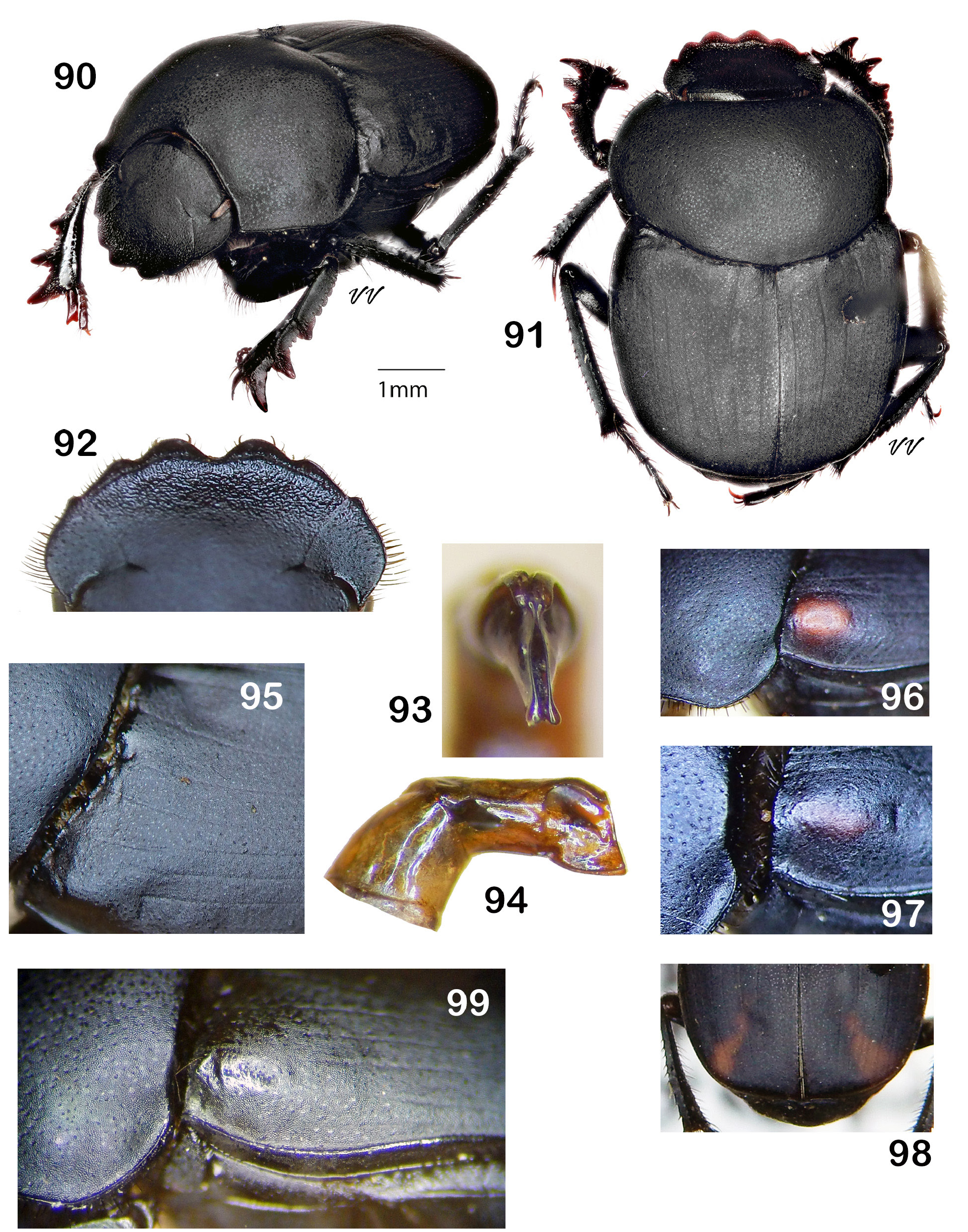
Fig. 90–101 View Figures 90–99 View Figures 100–101
Canthon simplex LeConte 1857: 41 View in CoL .
Canthon corvinus Harold 1868:129 View in CoL (new synonymy per Horn 1870: 46).
Canthon simplex var. militaris Horn 1870: 46 View in CoL (new synonymy per Robinson 1948: 87).
Canthon simplex var. humeralis Horn 1870: 46 View in CoL (new synonymy per Robinson 1948: 87).
Canthon simplex antiquus Pierce 1946: 120 View in CoL (new synonymy per Miller et al. 1981: 626).
Boreocanthon simplex (LeConte) View in CoL (new combination per Halffter 1958: 209).
Canthon (Boreocanthon) simplex (LeConte) View in CoL (new combination per Howden 1966: 727).
Boreocanthon simplex (LeConte) View in CoL , restored generic combination.
Canthon bisignatus Balthasar 1939: 229 View in CoL , new synonymy.
Canthon (Boreocanthon) bisignatus Balthasar 1939 View in CoL (new combination per Halffter and Martínez 1977: 82).
Type material. 1) Canthon simplex LeConte : syntype (male). Museum of Comparative Zoology, Cambridge, MCZ-ENT 00003699. Examined by photograph (https://mczbase.mcz.harvard.edu/guid/ MCZ:Ent:3699); 2) Canthon corvinus Harold : syntype (sex undermined), Museum für Naturkunde, Berlin. Examined by photograph courtesy F. V. Vaz-de-Mello; 3) Canthon simplex humeralis Horn : syntype? (female). Museum of Comparative Zoology, Cambridge, MCZ-ENT 00008108. Examined by photograph (https://mczbase.mcz.harvard.edu/guid/ MCZ:Ent:8108); 4) Canthon simplex militaris Horn : syntype? (female). Museum of Comparative Zoology, Cambridge, MCZ-ENT 00008109. Examined by photograph https://mczbase.mcz.harvard.edu/guid/ MCZ:Ent:8109); 5) Canthon bisignatus Balthasar : syntypes (two, sex undetermined), National Museum, Prague. Examined by photograph courtesy Jiří Hájek. 6) Canthon simplex antiguus Pierce : holotype (sex undetermined). Los Angeles County Museum of Natural History, LACMIP 2594. Not examined.
Type localities. 1) Canthon simplex LeConte : Oregon and California. 2) Canthon corvinus Harold : Sonora, California (see Comments); 3) Canthon simplex humeralis Horn : California, Coast Mountains south; 4) Canthon simplex militaris Horn : California, Tejon and Visalia; 5) Canthon bisignatus Balthasar : California; 6) Canthon simplex antiguus Pierce : Rancho La Brea, Tar Pits A and 81, Hancock Park, Los Angeles, California.
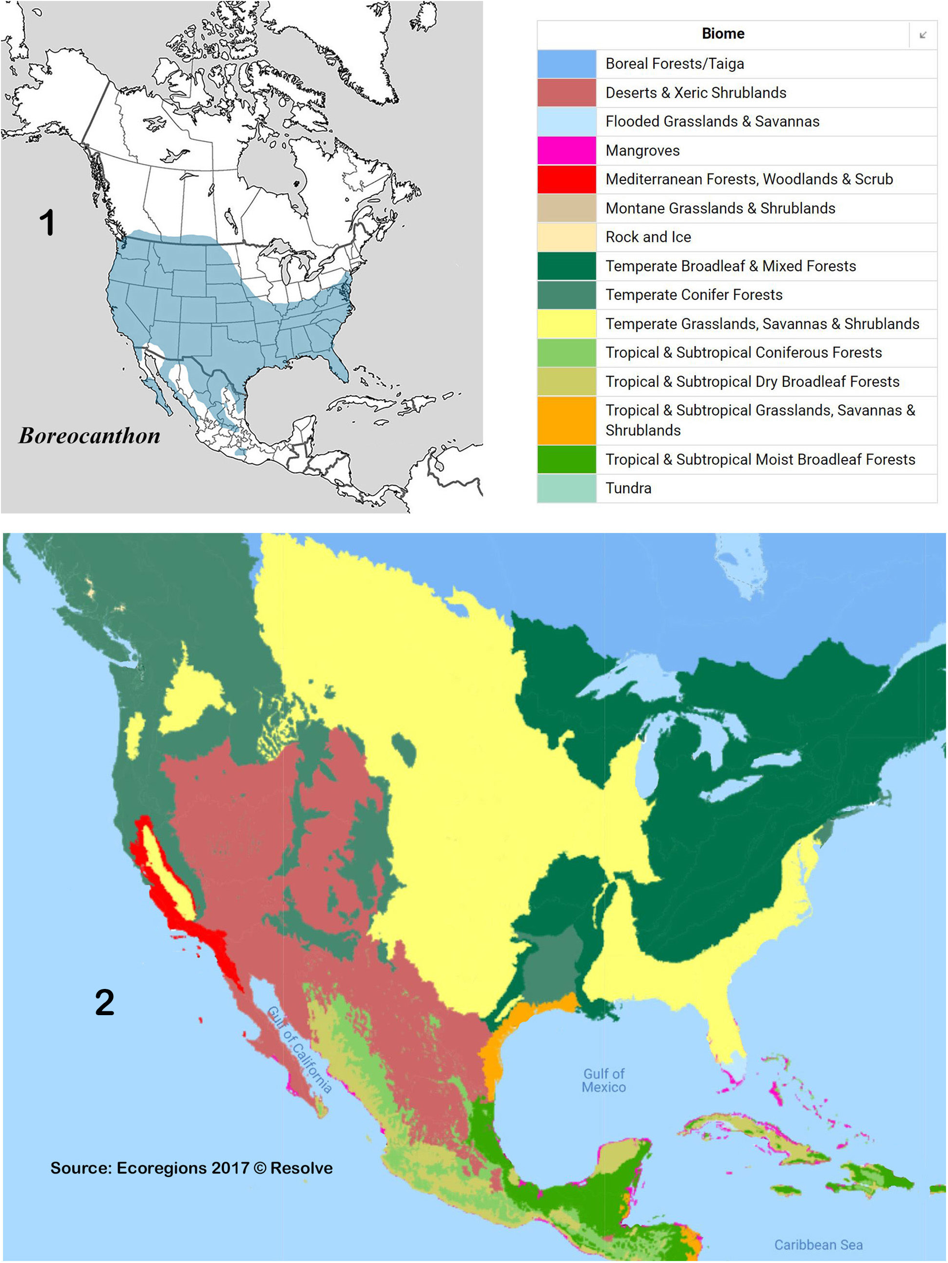
Diagnosis. Head: Anterior one-third of clypeus ( Fig. 92 View Figures 90–99 ) finely rugose, weakly shiny, posterior portion and paraocular areas minutely punctured on dense shagreen background, microspots very weak. Clypeus ( Fig. 92 View Figures 90–99 ) bearing four rather weak marginal teeth, median pair short, rounded apically, separated by rounded emargination, lateral pair small, angulate apically. Paraocular notch subtle, sometimes almost effaced, setting off very small, angular corner of the paraocular area. Labio-gular fimbria broadly triangular, apex extending about onethird length of gula. Prothorax: Pronotum ( Fig. 95–97 View Figures 90–99 ) evenly covered by dense shagreen and widely spaced punctures, microspots faint, denser than punctures. Anterior pronotal angles very weakly upturned, posteromedian angle at most only very weakly depressed; circumnotal ridge smooth posterolaterally. Hypomeral carina usually absent or only feebly developed, occasionally distinct. Pterothorax: Mesoventrite with few weak punctures on shagreen background; metaventrite with evenly distributed, widely spaced, small punctures. Elytra (see also Comments below): Interstriae covered by dense shagreen, microspots small, faint, discal interstriae with few, very widely spaced micropunctures; 2 nd and 3 rd not usually swollen apically; anterior margin of some or all interstriae 2–5 bearing minute tubercle (sometimes obscured by pronotal margin). Humeral umbone dull black, sometime shiny ( Fig. 99 View Figures 90–99 ) or with orange/red spot ( Fig. 96–97 View Figures 90–99 ). Elytral striae weak, edges not sharply defined; lateral striae (7-9), especially anterior one-half, often effaced or nearly so, 8 th stria never with any trace of carinula. Legs: Inner margin of protibia ( Fig. 90 View Figures 90–99 ) at most only gently widened at base of basal tooth. Protibial spur sexually dimorphic: strongly curved and apically acute in female, curved and apically bifurcate in male. Anterior margin of hind femora with conspicuous row of long setae, ventral surface punctate with few short setae. Abdomen: Pygidium evenly convex, uniformly dull; pygidium and 6 th abdominal ventrite sculptured as elytra, remaining ventrites smooth. Genital capsule: Compressed distal portion of parameres broadly triangular ( Fig. 94 View Figures 90–99 ), ventral apical angles in form of slender, elongate knobs ( Fig. 93 View Figures 90–99 ). General: Black, rarely weakly shiny, rarely with green or blue undertone on head, pronotum; elytral umbone sometimes partially or completely orange or red. Length: 4.5 – 8.0 mm. Geographic distribution ( Fig. 100–101 View Figures 100–101 ). Widely distributed in United States west of the Rocky Mountains. Ecogeographic environment: Desert and Xeric Shrublands, Temperate Conifer Forests, and Mediterranean Forests, Woodlands and Scrub biomes. Specimens examined: 3196.
Collection localities.
Note. Red diamonds mark collection localities with at least one observed specimen bearing orange/red elytral umbones.
CANADA — BRITISH COLUMBIA: Cariboo RD ● Chilicotin; East Kootenay RD ● Roosville [Aug] ● Kimberley [Jun] ● Cranbrook [May]; Columbia-Shuswap RD ● Salmon Arm [Apr]; Kootenay Boundary RD ● Rock Creek [Jul]; North Okanagan RD ● Vernon [Apr, Aug]; Thompson-Nicola RD ● Aspen Grove [Jul].
MEXICO — BAJA CALIFORNIA: Mpio. Ensenada ● 47 km E San Telmo (road to Parque Nacional San Pedro Mártir), 950 m [Jun] ● Rancho La Bellota, 32° 09.411 ʹ N 116° 27.680 ʹ W, 1863 ft [May] ● Mike ʹ s Sky Rancho, 4000 ft [Jun] ● San Vicente, 200 m [May] ● 43 mi E Ensenada, Santa Catarina, Sierra de Juarez , 3600 ft [Aug] ● Ensenada [Jun] ● 7 mi N Ensenada ● Santo Domingo [May] ● Valle de las Palmas [Nov] ● 20 mi S Santo Tomás [Aug] ● Punta Banda [Jun] ● 40 mi S Tecate.
UNITED STATES — ARIZONA: Apache Co. ● Chuska Mountains, Wagon Wheel Forest Camp, 36.452° N 109.1704° W [Aug] ● White Mountains, Diamond Creek [Jun]; Coconino Co. ● Bear Canyon [Jun] ● Flagstaff [Sep] ● 5 mi S Sedona, Red Rock Crossing Campground [Apr]; Cochise Co. ● Portal [Jul] ● Benson [Apr]; Gila Co. ● 0.5 mi W Miami ● 3 mi NE Gisela [Mar] ● 13 mi S Globe [Aug] ● Globe [Apr, Jul] ● Lake Roosevelt ● base Pinal Mts., 4000 ft [May]; Graham Co. ● 12 mi S Safford [May]; Maricopa Co. ● Tempe [Mar] ● Phoenix [Apr] ● Ft. McDowell [Apr-May] ● 0.5 mi SE Sunflower [Apr] ● Rock Springs, Agua Fria River [Apr]; Mojave Co. ● Beaver Dam (near Littlefield), 36°53 ʹ 41 ʺ N 113°55 ʹ 55 ʺ W, 1916 ft [Apr]; Pima Co. ● Tucson [Mar-Apr, Jun] ● Santa Catalina Mountains [Jun]; Pinal Co. ● Superior [Mar] ● 6 mi S Superior, 33.2162 N - 111.0655 W, 990 m [Apr-Jul] ● 3.5 mi W Superior, Boyce-Thompson Arboretum [Feb] ● Aravaipa Canyon [Apr]; Yavapai Co. ● Bumble Bee [May] ● 12 mi S Camp Verde, 3000 ft [Jun] ● 4 mi N Clarkdale ● 4 mi S Sedona [Jun] ● 34°13 ʹ 23 ʺ N 112°05 ʹ 37 ʺ W ● Hwy I-17, 2 mi S jct Hwy 179 [Apr] ● 2.1 mi NW Moctezuma Well, Moctezuma Castle National Monument, 3984 ft [May] ● 8 mi NE Yarnell [Jun] ● Prescott [Mar]. CALIFORNIA: Alameda Co. ♦ Oakland [Apr, Jun]; Alpine Co. ● Monitor Pass 8300 ft [Jun, Aug] ● 38.4504° N 119.5979° W, 8100 ft [Jun-Jul] ● Ebbett ʹ s Pass, 8950 ft [Jun] ● Bloods [Jul] ● Hope Valley, 7000ft [May]; Amador Co. ● El Dorado National Forest, Panther Creek Road [Jun]; Butte Co. ● Butte Meadows [Jun] ● Richardson Springs [May]; Calaveras Co. ● 13 mi E Dorrington [Jun] ♦ Mokelumne Hill [Jul] ● 5 mi NE Tamarack [Jun]; El Dorado Co. ● Kyburz [Jul] ● Caldor [Jun] ♦ Somerset [Jun] ♦ 13 mi E Georgetown, Blodgett Forest [Jun] ♦ Pacific House [Sep] ● Ice House [May] ● 3 mi N Wrights Lake [Jun] ● Camino [Jun] ● Twin Bridges, Pyramid Creek [Jun] ♦ White Hall [Jun] ● Mt. Ralston [Aug] ♦ Riverton [Jun-Jul] ● Placerville [Jun]; Fresno Co. ♦ Squaw Valley [Apr, Aug] ♦ 6 mi S Shaver Lake [May] ♦ Stevenson Creek, Sierra National Forest [May] ♦ Camp Greeley, 2800 ft [Jun] ♦ Huntington Lake, 7000 ft [Jul] ♦ Kings Canyon National Park [Jun, Aug] ♦ Lost Lake [Apr] ● Wishon Reservoir [Jul]; Humboldt Co. ♦ Willow Creek [Jun]; Kern Co. ♦ Tehachapi ♦ Grapevine [Apr] ♦ Lake Isabella [Jul] ♦ Kelso Valley Road [Apr] ♦ 2.5 mi NW Canebrake [Apr] ● 9 mi E Onyx ♦ Onyx [May] ♦ 9 mi N Onyx ● Frazier Park [Apr] ♦ Rancheria Creek, Walker Basin [Jun] ♦ Ft. Tejon ♦ Tejon Canyon [May] ♦ Deer Creek [Apr] ● Lebec (Dutchman ʹ s Camp) [Apr] ♦ 5 mi S Alta Sierra [Apr] ♦ Weldon [Mar]; Lake Co. ♦ Anderson Springs [May] ♦ Bartlett Springs [Jun]; Lassen Co. ● Hallelujah Junction [Jul] ● Norval Flats, 5500 ft [May, Jul] ● Hayden Hill [Aug]; Los Angeles Co. ● Los Angeles [May] ♦ Pasadena [Feb Apr-May] ● Claremont ● Big Tijunga Canyon [May] ♦ Fairmont [Apr] ● Azusa [May] ● Chilao Recreational Area, 5300 ft [May]; Madera Co. ♦ Oakhurst [May] ♦ Coarsegold [May] ♦ Bass Lake, 5000 ft [Jun-Jul] ● Sugar Pine ♦ Southfork [Jul]; Marin Co. ♦ Fairfax [Jul] ♦ Stinson Beach [Apr] ♦ Mill Valley [Aug] ♦ Inverness [Aug]; Mariposa Co. ● Yosemite Valley [Jun] ● Glacier Point, 7214 ft ♦ Fish Camp [May] ♦ Miami [Mountain] Ranger Station, 37°25 ʹ 09.62 ʺ N 119°44 ʹ 41.15 ʺ W [May]; Mendocino Co. ♦ Yorkville [May–Jun] ♦ Jumpoff Creek [Aug] ♦ 2 mi NW Philo, Navarro River [Jul] ♦ Newport; Modoc Co. ♦ Hackamore [Apr] ● Warner Mountains, near Lost Lake, 8000 ft [May-Aug]; Mono Co. ● 2 mi E Tioga Pass, 9500 ft [Jun] ● Mammoth Lake, 8000 ft [May-Jun] ● Hwy 108, Sonora Pass, 9700 ft [Jun-Jul] ● Saddleback Lake, 10000 ft [Jul] ● Bodie, 8500 ft [Aug]; Monterey Co. ● Stone Canyon [Apr] ● Paraiso Springs [Jun] ● Tassajara Hot Springs [May] ● Bradley [Apr] ● Carmel Valley [Jul] ● Bryson [Apr] ● Pacific Grove [Jun]; Napa Co. ♦ Napa [JunJul] ♦ Mt. St Helena [May-Jun] ● Deer Park [Jul]; Nevada Co. ♦ Grass Valley [May] ● 5 mi N Hobart Mills [Jun] ● Sagehen Creek [Jun] ● Truckee, 5800 ft [Jun, Aug]; Orange Co. ● Anaheim [Jun] ● Laguna Beach [Jun] ● Temple Hills [Mar] ● Laguna Beach [Jun] ● Laguna Niguel [Jun]; Placer Co. ● Tahoe City [Jul] ● Morongo Valley [May] ♦ Sugar Pine [Aug] ● Cisco [Jun] ● Colfax [Jun]; Plumas Co. ● Quincy ● Lake Almanor [Jun] ♦ Chester [Jul] ♦ Meadow Valley, 6000 ft [Jul]; Riverside Co. ● Cabazon [Apr] ● Riverside [Mar] ● Aguanga [May] ● 0.5 mi SE Aguanga [Apr] ● 8 mi SE Hemet, Bautista Canyon, 33°41 ʹ N 116°50 ʹ W, 2300 ft [Apr] ● Coahuilula Creek [May] ● 6 mi E Temecula [Mar] ● San Jacinto [Mar] ● Idyllwild [Jun-Jul] ● Palm Springs [May] ● 5 mi W Sage [Jul] ● Gavilan Hills [Apr] ● Goff Flats Campground, San Jacinto Mountains [Jul]; San Benito Co. ♦ Pinnacles National Monument [Apr, Jun]; San Bernadino Co. ● 2.9 mi N Cedar Springs [Jul] ● 0.9 mi NE Cedar Springs ● Colton [Mar] ● San Bernadino [May] ● Glenwood Springs [Aug] ● Deep Creek Campground [Jun] ● Big Bear Lake [May] ● Fawnskin [Jul]; San Diego Co. ● Campo [May] ● Scissors Crossing [Apr] ● 10 mi N Scissors Crossing [Jun] ● Lake Cuyamaca [Apr] ● Pamo Valley [Jun] ● Indian Flats Campground, Warner Springs [Jun-Jul] ● Dulzura [Apr] ● Boulevard [Jul] ● Mason Valley [Jun] ● Poway, 500 ft [Apr] ● Lake Moreno [Mar] ● Bonsall, Gopher Canyon Rd. [May] ● Camp Pendleton, 5 mi E I-5, Mateo Creek ● 6 mi E Banner [Jul] ● San Felipe Valley, 3000 ft [May] ● Murray Dam [May] ● Mt. Palomar [Jun] (See also McPeak et al. 2014 for additional San Diego Co. records.); San Francisco Co. ♦ San Francisco; Santa Barbara Co. ● Clear Creek, Cuyama Canyon [Mar] ● Santa Maria [Mar] ● Buellton [May] ● Santa Barbara ● 10 mi E Santa Maria, Cuyama River [Jul]; Santa Clara Co. ♦ 30 mi SE Livermore (Alameda Co.) [Jun]; Santa Cruz Co. ♦ Ben Lomond [Jun] ♦ Santa Cruz [Apr]; Shasta Co. ♦ Cayton [Jul] ● Old Station [May-Jun] ♦ Hat Creek (May-Jun] ● Shingletown [Jun]; Sierra Co. ● Sierraville [Aug] ● 10 mi S Sierraville [Jun]; Siskiyou Co. ● Yreka ● Walker [Jun] ● McCloud [Jun] ● Bartle [Jul] ● Cole [Jul] ● Klamath River [May] ♦ Taylor Lake, 5600 ft [Aug] ● Castle Lake, 5200 ft [Jul] ● Burney Valley [Aug] ● Mt. Hebron [Aug]; Sonoma Co. ♦ Mark West Springs [May] ● Mt. St Helena [Jun] ♦ Rio Nido [Aug]; Tehama Co. ● South Fork Battle Creek [Aug]; Trinity Co. ♦ Carrville, 2500 ft [Jun] ♦ Zenia [Jun] ● Plummer Spring [Jun] ♦ Hayfork [May] ● Mountain Meadows Ranch, head Coffee Creek, 5100 ft [Jul]; Tulare Co. ♦ Kaweah ♦ California Hot Springs [Jun-Jul] ● Sequoia National Park, Kings River Canyon [May] ♦ 2 mi E Johnsondale ● Shake Camp Campground [Jun] ♦ Porterville [May] ♦ Springville; Tuolumne Co. ● Tuolumne Meadows ● Sonora Pass, 38.3281° -119.6371°, 2950 m ● Spring Gap [Jun] ♦ Strawberry [Aug] ♦ Twain Harte [Mar] ♦ 17 mi S Sonora [May] ♦ Pinecrest [Jun-Jul] ♦ Hardin Flats [May] ♦ 6 mi E Groveland, 2800 ft [Jul]; Ventura Co. ● Lake Piru [Jun] ● Ventura [May] ● Sespe Canyon [Apr] ● Santa Paula [Nov]; Yolo Co. ♦ Rumsey [May]; Yuba Co. ● Strawberry Valley [Sep]. COLORADO: Boulder Co. ● 8mi SW Boul-der, 8400 ft [Jul]; ● Ward ● Gold Hill [Jul]; El Paso Co. ● Cascade [Jul]; Fremont Co. ● Coal Creek [May]; Garfield Co. ● Glenwood Springs [Jul]; Gunnison Co. ● 8 mi NE Almont, One Mile Canyon, 8200 ft [Jul] Jackson Co. ● Walden [Aug]; Larimer Co. ● Estes Park, 40°21 ʹ 11 ʺ N 105°28 ʹ 45 ʺ W, 2500 m [Aug] ● Red Feather Lake [Jun]; Mineral Co. ● Creede [Jul]; Moffat Co. ● 10 mi W Maybell [Jun]; Ouray Co. ● Ouray [Jul]; Routt Co. ● Steamboat Springs [Jun]; Teller Co. ● Florissant Canyon, 8500 ft [Jul]. IDAHO: Ada Co. ● Boise, 2690 ft [May]; Adams Co. ● Packer Johns Cabin State Park [Jun] ● 6 mi E New Meadows [Jun]; Bear Lake Co. ● Montpelier ● Georgetown [May] ● Paris [May]; Bannock Co. ● Pocatello [May, Jul] ● Lava Hot Springs; Benewah Co. ● St. Maries [Aug]; Blaine Co. ● Prairie Creek [Jul] ● Frenchman Creek, Hwy 75 below Galena Summit ● 10 mi S Bellevue [May] ● Clarendon Hot Springs [Jul]; Boise Co. ● Thorn Creek [Jul] ● Gardena [Jun] ● 8.5 mi NE Gardena [Jun]; Bonner Co. ● Sagle [Jun] ● Sandpoint, 2085 ft [May-Jul] ● Priest River Experimental Forest [Jun] ● Granite [Jun]; Bonneville Co. ● Gray ʹ s Lake [Apr] ● Willow Creek [Jun]; Butte Co. ● Craters of the Moon National Monument, Little Cottonwood Creek [Jun-Jul] ● 6 mi S Howe [May]; Caribou Co. ● Diamond Point [Aug] ● 6 mi SW Soda Springs [Apr] ● 3 mi E Wayan [Jun]; Clark Co. ● Dubois [Jun] ● Camp Creek, 5 mi S Humphrey [Jul]; Clearwater Co. ● Elk River [May] ● 1 mi N Elk River [May]; Custer Co. ● Double Springs Ranch [Jun]; Elmore Co. ● 11 mi S Pine [Jun] ● 8.5 mi E Featherville [Jun] ● Little Camas Reservoir [Jun]; Fremont Co. ● St Anthony [Jul] ● Coal Creek [May]; Gem Co. ● Sweet [Jul]; Kootenai Co. ● Worley [May] ● Chilco [May] ● Coeur d ʹ Alene, 2150 ft [May-Jun] ● 6 mi W Athol [Jun]; Latah Co. ● Moscow, 2560 ft [Apr, Jun-Jul] ● Bovill [Apr] ● 5 mi N Troy [May] ● Spring Valley Reservoir [Apr, Jul]; Lewis Co. ● Winchester [May]; Lincoln Co. ● Shoshone [Jul]; Madison Co. ● Driggs [Jun]; Nez Perce Co. ● Gifford [May]; Oneida Co. ● Sublette Canyon [Apr]; Owyhee Co. ● 17 mi W Silver City; Shoshone Co. ● Wallace [Jun, Aug] ● 3.4 mi N Clarkia; Teton Co. ● Tetonia [Jul]; Twin Falls Co. ● Timber Canyon [Jul] ● Steamboat Rock [Jun]; Valley Co. ● Bear Valley [Jul] ● Cascade [May] ● Donnelly [May]; Washington Co. ● 7 mi NW Midvale [Apr]. MONTANA: Beaverhead Co. ● Centennial Valley [May] ● Dillon [Jul] ● Birch Creek [Aug]; Broadwater Co. ● Limestone Hills (near Townsend), 46°17.54 ʹ N 111°36.45 ʹ W; Flathead Co. ● Big Creek, Flathead National Forest ● Glacier National Park, Colby Meadow [Jun-Sep]; Gallatin Co. ● 7 mi S Logan, Madison Buffalo Jump State Park [May] ● Willow Creek [Jun]; Hill Co. ● Beaver Creek, 6300 ft; Lake Co. ● Ronan [Jul-Aug]; Lewis and Clark Co. ● Helena [Jul]; Madison Co ● 9 mi S Alder, Ruby Reservoir [Jul]; Meagher Co. ● Ringling [Apr]; Missoula Co. ● Salmon Lake, 7.5 mi N jct. hwys 200 & 83 [Jul]; Park Co. ● Crazy Mountains, 5000 ft [Jun]; Ravalli Co. ● Hamilton [Jun] ● Camp Creek [Jul] ● Gird Creek [Jul] ● Flathead Lake [May] ● Darby [Aug]; Sanders Co. ● Thompson Falls [Jun]; Sheridan Co. ● Sheridan [Aug]. NEVADA: Clark Co. ● 10 mi N Paradise [Jun] ● Elko Co. ● Elko [Jul] ● Wildhorse Crossing State Park [Sep] ● Jarbidge [Jul]; Lander Co. ● 18 mi S Austin [Jun]. NEW MEXICO: Catron Co. ● Luna [Apr]; Sandoval Co. ● Valles Caldera National Preserve, Valle Grande, 35°53 ʹ N 106°30 ʹ W [Jul]. ORE-GON: Baker Co. ● Whitman National Forest, Eagle Mountains, Skookum Creek ● Pine Creek, Blue Mts, 4000 ft [Aug] ● Baker [Apr, Jul]; Benton Co. ● Monroe [Jun] ● Corvallis [May-Aug] ● McDonald Forest, Oak Creek [Apr]; Deschutes Co. ● 16 mi SE LaPine [May] ● 7 mi NW LaPine, Pringle Butte, 4000 ft [Apr] ● Paulina Creek [Aug]; Douglas Co. ● Riddle [May]; Grant Co. ● Graylock Butte [Jul] ● Dixie Pass, 5200 ft ● Silvies [Jun]; Harney Co. ● Steens Mountain, 6500 ft [Jun-Jul] ● Hwy 20, mile marker 156, near Buchanan [Mar-Jun] ● Steens Mt., above Fish Lake, 8000-9000 ft [Jun]; Hood River Co. ● 4 mi W Oak Grove [May-Jun]; Jackson Co. ● Medford [Apr-May] ● Colestin [Jul] ● Gold Hill [Apr]; Jefferson Co. ● 0.3 mi E Horseshoe Lake [Jul-Aug] ● Santiam Pass, 5000 ft [Jun]; Josephine Co. ● Grants Pass [Jul]; Klamath Co. ● Worden [Jul] ● Collier State Park [Jul] ● Klamath Lake [Jun] ♦ Fremont National Forest [Jun] ● Crater Lake [Jul] ● Bly, Meryl Lake [Jun] ● 7 mi NE Bly, Deming Creek [Jul] ● 8 mi N Bly, Preacher Creek [May] ● Spencer Creek [Jun] ♦ Algoma [Apr]; Lake Co. ● 15 mi E Lakeview [Jun] ♦ Warner Canyon, near Lakeview [Jun-Jul] ● 12 mi SW Silver Lake [Aug]; Lane Co. ● 10 mi NNW Junction City [Sep] ● 11 mi NE Blue River, H.J. Andrews Experimental Forest [Jun]; Marion Co. ● Pratum; Multnomah Co. ● Portland [Jun]; Umatilla Co. ● Tollgate [Jun] ● Meacham, 4300 ft [May-Jun] ● Cold Springs [Jun]; Union Co. ● 28 mi SE Union 4280 ft [Jul] ● La Grande [Jun] ● 0.2 mi N Rd. 77 on Rd. 600, 5550 ft [Jun] ● Kamela [Jun]; Wallowa Co. ● Hwy 3 at Day Ridge Road, 25 mi N Enterprise, 4700 ft [Sep] ● Zumwaldt Prairie Reserve [Jun] ● Blue Creek, 4170 ft; Wasco Co. ● 16.5 mi E Hwy 35 on Hwy 44, 2800 ft [Jun-Jul]; ● 6.4 mi E Rd. 1720 on Upper Fivemile Rd.; 14.8 mi E Hwy 35 on Hwy 44, Hood River National Forest [Apr] ● 10.1 mi W Dufur Road on Hwy 44, 45°24.882 ʹ N 121°19.524 ʹ W, 2732 ft [May] ● Mt. Hood National Forest, Clear Creek Campground [Jun]; Washington Co. ● Forest Grove [May]; Wheeler Co. ● Walton Lake [Jun]; Yamhill Co. ● McMinnville [Apr-May]. UTAH: Box Elder Co. ● Rosevere Creek, Raft River Mountains [Jun]; Cache Co. ● Logan Canyon, 7200 ft [May] ● Bear Lake, summit Logan Canyon [Jun] ● Tony Grove [Jul] ● Sardine Canyon ● Wellsville Canyon [Jun]; Carbon Co. ● 8 mi NE Castlegate [Jun] ● Scofield Reservoir [Jun]; Duchesne Co. ● Hanna [Jul]; Juab Co. ● Nephi Canyon [Jun] ● Chicken Creek Campground, 5 mi E Levan [Sep]; Morgan Co. ● Cottonwood Canyon, Cache National Forest [Jul] ● Lost Creek, above Lost Creek Reservoir [Jul]; Rich Co. ● Logan Canyon [May-Jun] ● Birch Creek Reservoir [Jul] ● Otter Creek Spring, 12 mi W Randolph [Jun] ● Laketown Canyon; Salt Lake Co. ● Little Cottonwood Canyon, Wasatch Mountains [Jul]; Sanpete Co. ● Boulger Lake, Wasatch Plateau [Jun] ● Indianola [May]; San Juan Co. ● Blanding [Jul] ● Ute Mountains (Colorado state line) [Jun]; Tooele Co. ● Oquirrh Mountains, Settlement Creek Canyon [Jul]; Utah Co. ● Timpanogos, Wasatch Mountains [Jun] ● Aspen Grove, 7000 ft [May, Aug] ● Provo [Apr, Sep] ● Provo Canyon [Sep] ● American Fork Canyon, 9500 ft [Aug] ● Payson Canyon [Jul] ● Payson Lakes [Jun] ● Sundance [May] ● Timpanogos Lodge [May] ● Squaw Peak [Aug] ● Alpine [May]; Wasatch Co. ● Strawberry Reservoir [Jun-Jul] ● Provo River [Jun] ● Silver Lake [Jul]; Wasatch Mt. State Park [May] ● Cascade Springs [AprMay] ● Daniels Canyon, 8000 ft [Jul]; Washington Co. ● St. George ● Leeds Canyon [Apr] ● Lytle Preserve, 37.14490° N 114.02283° W, 836 m [Sep] ● Lytle Ranch, Welcome Spring [Jun] ● Snow Canyon Dunes [Mar-Apr] ● Red Cliffs Recreation Area, Red Cliffs Campground [Apr] ● Toquerville. WASHINGTON: Asotin Co. ● 8 mi SE Clearwater Ranger Station (near Mt. Misery); Benton Co. ● Prosser [May]; Chelan Co. ● Riverhead Campground, Wenatchee National Forest [Jun]; Ferry Co. ● 10 Mile Creek Campground, 48.515 -118.739, 1800 ft [Jun]; Klickitat Co. ● Spearfish [Jul] ● Glenwood, 0.2 mi N jct. Ladiges Rd on Bird Creek Road., 46°01.955 ʹ N 121°18.255 ʹ W, 1993 ft [May]; Kittitas Co. ● 13 mi NE Kittitas [May] ● Easton ● Lake Cle Elum [Jun]; Pend Oreille Co. ● 5.8 mi SW Tiger, Nile Lake, 3400 ft [Aug] ● Leo Lake, 3150 ft [Jun]; Snohomish Co. ● Lewis Peak, Blue Mts. [Jun]; Spokane Co. ● Mt. Spokane, 5000-5800 ft; Stevens Co. Northport [Jun] ● Pleasant Valley [May, Oct]; Walla Walla Co. ● Lowden [May] ● Walla Walla [Apr-May]; Whitman Co. ● Pullman [Mar-May, Jul] ● Palouse, Kamiak Butte [AprMay]; Yakima Co. ● Bird Creek Ford, Yakima Indian Reservation, 2500 ft [Jun] ● 5 mi W, 2 mi N Wenas Lake ● Toppenish [May]. WYOMING: Albany Co. ● 5 mi W Garrett [Jul] ● Medicine Bow National Forest, Curtis Gulch Campground [Jul]; Big Horn Co. ● Trout Creek [Jun]; Fremont Co. ● Sweetwater Station [Jun]; Natrona Co. ● Bates Creek, 22 mi S Casper, 7000 ft [Aug]; Park Co. ● Lake Creek Camp, 13 mi SE Cooke City, MT, 7200 ft [Jul]; Sublette Co. ● Fremont Lake [Jul] ● Half Moon Lake [Jun]; Sweetwater Co. ● Burntfork [Jun] ● Green River [Jul]; Teton Co. ● 43.61735° N 110.42963° W, 7300 ft [Aug] ● Yellowstone National Park, Lamar Valley [May] ● Yellowstone National Park, Trumpeter Swan Lake, 6080 ft [Sep] ● Jackson Lake, Teton National Park [May] ● Jackson Hole, 6300 ft [Jul, Sep] ● Jenny Lake [Jun]; Washakie Co. ● 12.5 mi ESE Ten Sleep, Ten Sleep Preserve (The Nature Conservancy) [Jun].
Comments. There is potential confusion regarding the date of publication (1857 or 1860) of this LeConte species. Moore (1986) pointed out that the various parts of the Steven’s survey were published hastily and piecemeal and only later grouped and formally published in book form in 1860 — making it, in Moore’s words, a “collater’s nightmare.” LeConte, and perhaps other contributors, evidently opted to commission a private “preprint” of his results, which he distributed to colleagues years in advance of the issue of the complete report. I have not seen a copy of LeConte’s “preprint” but, in the light of Moore’s commentary and the fact that the 1857/1860 duality is of no nomenclatorial consequence, I accept the long-standing reported date of publication as 1857.
Thanks to Dr Jiří Hájek of the Czech National Museum, Prague, I have examined photographs of the two syntypes there of Canthon bisignatus Balthasar. In his study of Canthon, Balthasar (1939) considered eleven species here assigned to Boreocanthon , including B. simplex and a new species, Canthon bisignatus . The latter he separated from the remaining species, including B. simplex , in couplet 77(232) of his identification key (p. 190), [“Clypeus bidentate, lateral teeth either completely absent or indicated at most only by a weakly angulate thickening of the clypeal margin.“], terminating at couplet 146(147). Both syntypes are clearly highly worn individuals of B. simplex whose originally quadridentate clypei have been rendered weakly bidentate by severe abrasion; moreover, both have bright red/orange elytral umbones. One bears the label, Canthon simplex humeralis Horn, Det. B. D. Gill ’96. Since, to my knowledge, the synonymy of Canthon bisignatus Balthasar with Boreocanthon simplex has not heretofore been established formally, I do so here.
In addition to the syntype for Canthon simplex LeConte cited above (labeled by blue disk as Oregon / Washington), there are two additional likely syntypes also present in the LeConte Collection at the Museum of Comparative Zoology (Crystal Maier, pers. comm). These are labeled (brown disk) as “Russian America”, a possible reference to Fort Ross in present day Sonoma County , or other colonial outpost in California operated by the Russians until 1841 ( Ballard 1997). Potential syntypes of Horn’s (1870) varieties humeralis and militaris also reside in the MCZ collection. But in each case, the specimen depicted in the MCZ database (see photographs referenced above) as putative type material was, for an unknown reason, drawn from the LeConte Collection (Crystal Maier, pers. comm.) and, therefore, not strictly attributable to Horn. For this reason, I have added “?” to the syntype designations above.
Canthon simplex antiquus View in CoL was one of two fossil taxa described by Pierce (1946) from asphalt deposits at Rancho La Brea in Los Angeles, California. It, along with C. praticola vetustus Pierce , are both considered conspecific with modern species ( Miller et al. 1981; see Comments for B. praticola View in CoL ).
Horn (1870) recognized four varieties of B. simplex View in CoL , viz., simplex View in CoL , corvinus View in CoL , militaris and humeralis. The second, corvinus View in CoL , was in reference to Harold’s (1860) species, which he explicitly rejected as deserving species status (“I cannot agree with Harold in separating corvinus View in CoL as distinct.”). Similarly, it is reasonable to assume that his “ var. simplex ” was a direct reference to LeConte’s species. Only the remaining two varieties, var. humeralis View in CoL and var. militaris View in CoL , are here considered Horn taxa and, in accordance with ICNZ Article 45.6.4, are to be treated as subspecific names. Horn’s (1870: 46) estimation of his varieties was blunt: “My own series is large, and my observation in California leads me to consider all these forms as mere local varieties and not distinct species.” Robinson (1948: 88) later came to a similar conclusion, although he went farther by rejecting Horn’s notion of local varieties altogether: “I think simplex View in CoL is just a very variable species without any correlation between the internal and external variations and geographic localities, and therefore see no reason for continuing to split it into several varieties.” I agree with Robinson’s viewpoint.
I am inclined to believe that my taxonomic view of this species could be too simplistic — Boreocanthon simplex is anything but “simplex.” As for morphological features, its only real constant is the shape of the head margin, with reduced clypeal teeth and weak paraocular notch ( Fig. 92 View Figures 90–99 ). Most specimens also show weakly expressed lateral elytral striae (7 th and 8 th), which, especially viewed obliquely from the side ( Fig. 95 View Figures 90–99 ), appear almost effaced basally. A common variable is the conspicuousness (“crispness”) of pronotal puncturing, which varies continuously from nearly effaced to clearly expressed; the latter state figures in Harold’s definition of his “ var. corvinus .” The elytral umbones, while dull black ( Fig. 95 View Figures 90–99 ) over most of its range, can be colored ( Fig. 96–97 View Figures 90–99 , see below). I have not been able to sort these variables and others in any useful taxonomic way, and thus I, like previous observers (see below), have concluded that it is but a very common, widely distributed, highly variable species. A future student of the group might find it to be a complex array of populations with greater or lesser connections inter se — in other words, with other data (e.g., molecular) it might be possible to delimit multiple species, or semispecies or subspecies. Halffter (1958) fittingly recognized B. simplex as the most variable species in the genus and suggested that it could represent a “… [a Rassenkreiss or polytypic species with geographic subspecies … or {several} well-defined species]”.
Perhaps the best known manifestation of variation in B. simplex is the color and luster of the elytral umbones. The most common condition throughout its range is the combination of dull, black umbones ( Fig. 90, 95 View Figures 90–99 ). Umbone luster varies irregularly but can be weakly shiny in contrast to the dull surrounding elytral surface in certain populations ( Fig. 99 View Figures 90–99 ). In some places, preponderantly in the mountainous zones surrounding the Central Valley of California (see Fig. 101 View Figures 100–101 and collection localities listed above marked with red diamond ♦) a portion of the population bears umbones marked by an orange (reddish/red) spot. In most of these places, the colored umbones vary in size and intensity and occur along with all-black specimens. The types of the “varieties” militaris, humeralis and corvinus , as well as that of Canthon bisignatus , all bear orange markings, but only in the case of militaris are they cited in Horn’s formal descriptions (1870:46). However, Harold (1868) does say, in his comments on corvinus , “[The number of individuals with red umbones is almost more than the solid black form.]” Moreover, he cites “Sorona, California ” as type locality for his species, which I regard as a typographical error meaning Sonora, California (Tuolumne Co.). Individuals with orange umbones almost always occur with black individuals and are absent outside of California and southern Oregon. Among the 3000+ specimens examined for this study, I have seen only one outlier specimen with orange umbones; it is labeled LaGrande (Union Co.) in far northeastern Oregon, a record I consider in need of corroboration. Robinson (1948) reported red/orange umbones in specimens from California, Oregon, Colorado and Arizona, but I have seen none from either of the latter two states. I have seen one unusual specimen of B. simplex (Pinnacles National Park, California) in which the orange color of the umbones, which are black, has “slipped” to the apices of the elytra ( Fig. 98 View Figures 90–99 ). Mario Cupello (pers. comm.) reports similar variability in umbone color in several South American scarabaeines, including Ateuchus globulus (Boucomont) and Pseudocanthon xanthurus (Blanchard) .
I have examined a single, unusual specimen of B. simplex that I take as a sign of latent variability of this species in addition to that expressed across its range. It is from among numerous specimens collected at the Miami Ranger Station, Mariposa County , California. It is striking because it conserves distinct, but attenuated granules on the elytra, which normally present only shiny microspots. In addition, unlike “typical” B. simplex , the elytral striae are strongly accentuated. The pronotum of this specimen presents microspotting and conspicuous puncturing.
Given its morphological variability, it is not surprising that B. simplex is also highly variable from other points of view. Recorded food sources include the excrement of cattle, horses, humans, elk, deer, goat, rabbit, bear, and unidentified carnivores, as well as snake and porcupine carcass and other carrion. Its geographical range embraces widely disparate ecological settings, from conifer forests through desert steppe and scrub (cf. Fig. 2 View Figures 1–2. 1 and 100 View Figures 100–101 ). Richard Cunningham (pers. comm.) reports collecting it from woodrat nests in Arizona. The recorded elevational spread of B. simplex is the widest of any Boreocanthon (and perhaps any other native U.S. dung beetle): from below 1,000 ft along the coastal ranges of the western U.S., to the summit of several mountain passes over the Sierra Nevada ranges in California (Sonora Pass, Mono County, 9,700 ft; Saddlebag Lake, 10,100 ft) and Utah (summit of American Fork Canyon, Utah County, 9,500 ft.). The distribution of B. simplex is not entirely blocked by a Rocky Mountain barrier; I have seen a few specimens from points east, mostly in the region of the Teton Mountains in Wyoming.
Occurrence of this species in the Great Basin is very poorly known – Figure 100 View Figures 100–101 is presumptuous in showing it to occupy the entire region. I have seen fewer than 10 specimens from that enormous area and I assume that its rareness is result of poor collecting. It is noticeably absent or at least very scarce, or appears to be, from the Central Valley of California – confined largely to the surrounding mountains, and Pacific coastal region west of the coastal ranges as far south as northwestern Baja California (see Horn 1894: 304). The northern limit of the distribution of this species is far southern British Columbia ( McNamara 2013; Macqueen and Beirne 1974). McNamara (2013) recorded B. simplex from British Columbia and Alberta; the latter record, while not out of the question, needs confirmation.
The collection at Carnegie Museum of Natural History (Pittsburgh) includes a single specimen of B. simplex bearing the label “ Santa Fe Canon [sic], 7000 ft, Aug. 1880, Snow,” presumably collected outside the city of Santa Fe by F. H. Snow. However, the report of the results of Snow’s 1880 collecting trip to Santa Fe ( Snow 1880) , however, mentions only three scarabaeines, Canthon praticola and two species of Onthophagus , the new species O. coproides Horn, 1881 , and O. hecate (Panzer, 1794) . I am strongly inclined to conclude that it was mislabeled by Snow or by someone else. Robinson (1948) reported this species from Sonora, Mexico, which I am unable to corroborate.

| MCZ |
Museum of Comparative Zoology |
| V |
Royal British Columbia Museum - Herbarium |
| MT |
Mus. Tinro, Vladyvostok |
No known copyright restrictions apply. See Agosti, D., Egloff, W., 2009. Taxonomic information exchange and copyright: the Plazi approach. BMC Research Notes 2009, 2:53 for further explanation.
|
Kingdom |
|
|
Phylum |
|
|
Class |
|
|
Order |
|
|
Family |
|
|
Genus |
Boreocanthon simplex ( LeConte, 1857 )
| Edmonds, W. D. 2022 |
Canthon (Boreocanthon) bisignatus Balthasar 1939
| Halffter G & Martinez A. 1977: 82 |
Canthon (Boreocanthon) simplex (LeConte)
| Howden HF 1966: 727 |
Boreocanthon simplex (LeConte)
| Halffter G. 1958: 209 |
Canthon simplex antiquus
| Miller SE & Gordon RD & Howden HF 1981: 626 |
| Pierce WD 1946: 120 |
Canthon bisignatus Balthasar 1939: 229
| Balthasar V. 1939: 229 |
Canthon simplex var. militaris
| Robinson M. 1948: 87 |
| Horn GH 1870: 46 |
Canthon simplex var. humeralis
| Robinson M. 1948: 87 |
| Horn GH 1870: 46 |
Canthon corvinus
| Horn GH 1870: 46 |
| Harold 1868: 129 |
Canthon simplex
| LeConte JL 1857: 41 |