
Rubus lentianus Hohla, Király, M. Lepší & P. Lepší, 2023
|
publication ID |
https://doi.org/ 10.11646/phytotaxa.594.1.2 |
|
DOI |
https://doi.org/10.5281/zenodo.7868852 |
|
persistent identifier |
https://treatment.plazi.org/id/D8448793-FFA1-FFD8-FF45-0BBEFDA5FB5D |
|
treatment provided by |
Plazi (2023-04-24 09:40:57, last updated 2023-11-09 07:26:16) |
|
scientific name |
Rubus lentianus Hohla, Király, M. Lepší & P. Lepší |
| status |
sp. nov. |
Rubus lentianus Hohla, Király, M. Lepší & P. Lepší View in CoL , spec. nov. ( Figs 1–3 View FIGURE 1 View FIGURE 2 View FIGURE 3 )
Type: — AUSTRIA. Upper Austria: distr. Rohrbach, Hintenberg , quadrant 7349bad, ca 1.2 km ESE of chapel in village, in scrub, one large growth, 730 m, 48°40’59.23”N, 13°56’27.56”E, 15 August 2020, M. Lepší & P. Lepší s.n. (Holotype: LI 03455388 ! isotypes: CB 87544 !, M 0292443 !) ( Fig. 1 View FIGURE 1 ) GoogleMaps .
Description:—Shrub, usually up to 100 cm tall. First-year stems low to medium-arching, rooting at the apex, angled with ± flat sides, (3.0–)4.0–6.0 mm in diameter; dull greenish purple to conspicuously suffused with dark brown-red when exposed to the sun; with 0.1–0.5 mm long, adpressed to erect simple, fasciculate (mostly with two arms) and rarely stellate hairs, (5–)15–30(–50) hairs per 1 cm of stem side. Sessile and subsessile glands scattered, stalked glands uneven, up to 0.5 mm long, (1–)4–10(–15) per 1 cm of stem side, acicles scattered, 0.3–0.8 mm long, bristles rare. Prickles suffused with dark brown-red with a long, yellowish tip, ± equal, straight, slightly to distinctly declining (rarely patent), (6–)10–18(–22) per 5 cm of stem length, (4–)5–7(–9) mm long, compressed with a flattened base (3–)4–5(–6) mm broad. Primocane leaves pedate, usually 5-foliolate, but also 3- or 4-foliolate leaves present, leaflets remote to contiguous. Laminas flat, somewhat leathery, dark green above with (1–)3–10(–25) hairs per 1 cm 2, hairy to the touch beneath, greenish-grey felted, with dense stellate and few longer simple hairs. Venation medium weak, veins slightly depressed into the surface of the leaf.
Terminal leaflets obovate to broadly obovate, rounded or truncate at the base, abruptly narrowing into a (10–)15–22(–26) mm long apex, petiolule (22–)28–34(–40) % as long as its lamina; margin slightly undulate, ciliate, indentation periodical, coarse, with partly recurved 2–4 mm long teeth, incisions (2.5–)4.0–5.0(–6.0) mm deep. Basal leaflets elongate, oblong or narrowly obovate, on ternate or quinate leaves often irregularly lobed or incised; petiolules (1.5–)2.5–4.5(–5.5) mm long. Petioles shorter than basal leaflets, loosely to densely hairy, with scattered subsessile and stalked glands, rare acicles and bristles, and with (6–)10–15(–18) hooked prickles. Stipules filiform, with scattered mostly simple hairs and sessile and stalked glands, usually (0.5–)0.7–0.9(–1.3) mm wide.
Inflorescence usually 15–20(–30) cm long, conical, narrow to medium wide, truncate at the apex, with erectopatent or (in upper part) patent branches, distal (5–)7–10(–16) cm long part leafless. Inflorescence leaves greenish-grey and felted beneath, predominantly ternate, the uppermost 1(–2) simple. Inflorescence axis flexuous, densely hairy, with scattered stalked glands and fewer acicles and bristles, and with (7–)9–13(–15) prickles per 5 cm of axis length. Prickles unequal, declining, slender, straight to slightly curved, (3.0–)3.5–4.5(–5.5) mm long. Inflorescence branches 1–3-flowered; pedicels (5–) 10–20 mm long, felted, with scattered stalked glands or acicles up to 0.6 mm long, the longest ones longer than hairs, and with (4–)6–10(–14) ± equal, slightly curved, (1.0–)1.5–2.0(–3.0) mm long prickles. Sepals (5–)6–7(–8) mm long (including the short filiform appendix), first spreading to slightly reflexed and reflexed after anthesis, green-grey felted with whitish margins, with scattered simple hairs, scattered red subsessile and stalked glands and absent to rare short, red-suffused pricklets on the abaxial surface. Petals pink, hairy to densely hairy, spathulate, not touching each other, 8–10 mm long. Stamens significantly longer than styles, filaments white, anthers yellow, glabrous. Carpels hairy, styles yellowish green. Receptacle sparsely to densely hairy, with hairs up to 1.2 mm long. Collective fruits semiglobose to globose. Flowering (VI–)VII(–VIII).
DNA-ploidy level:—Flow cytometric analysis has shown that Rubus lentianus is tetraploid (2n = 4x ~ 28). Because all taxa (ca. 15 species) of Rubus ser. Radula investigated so far have proved to be tetraploid ( Krahulcová et al. 2013), this ploidy was expected.
Etymology:—The epithet ‘ lentianus ’ derives from the Roman name of the city of Linz (‘ Lentia ’), the provincial capital of Upper Austria.
Diagnostic characters:—Primocanes conspicuously dark, dull greenish purple to suffused with dark brown-red when exposed to the sun, scattered to medium densely hairy, with scattered stalked glands, rare to scattered acicles or bristles and (6–)10–18(–22) prickles per 5 cm of stem length; prickles suffused with dark brown-red, with a long, yellowish tip; leaves on primocanes mostly pedate (3–4–)5-foliolate, hairy to the touch beneath; indentation periodical, conspicuously coarse, with some recurved 2–4 mm long teeth and incisions (2.5–)4.0–5.0(–6.0) mm deep; terminal leaflet abruptly narrowing into a distinctive (10–)15–22(–26) mm long apex. Pedicels felted, with scattered stalked glands or acicles up to 0.6 mm long, the longest ones longer than hairs.
Taxonomy:—Due to ± equal, uniform prickles and scattered stalked glands on primocanes and a greenish-grey indumentum of primocane leaves beneath, Rubus lentianus is a typical member of the series Radula . Deeply incised terminal leaflets of primocane leaves with a long and abruptly narrowing apex separate the species from all other members of the series Radula recorded within the distribution area of R. lentianus and adjacent regions. Most of all it resembles R. perpedatus , which differs in having 3–20 hairs per 1 cm of primocane side, primocane leaves (very) distinctly pedate, incisions of the terminal leaflet only 2–4 mm deep and pedicels with stalked glands shorter than the longest hairs. Another similar species, R. rudis , has, in contrast to R. lentianus , incisions of terminal leaflets of primocane leaves only 1.5–2.5(–3.0) mm deep, primocanes almost glabrous, with numerous short stalked glands and with smaller, (3–)4–6(–7) mm long prickles. To ease the separation of R. lentianus from all other members of ser. Radula actually or possibly co-occurring with the new species, we present a determination key below. The key does not include R. indusiatus and R. platycephalus , whose distribution, morphology and taxonomy is insufficiently known, as indicated by our research and other published data (cf. Trávníček et al. 2018). However, it is apparent from the type material and published descriptions ( Weber 1997) that both taxa differ significantly from the new species. Rubus platycephalus can be distinguished mainly by 3-foliolate primocane leaves with shallower, 2–2.5 mm long incisions and shorter, 10–12 mm long apex; R. indusiatus differs in having primocane leaves with shallower, 1.5–2 mm long incisions and a narrow, ± cylindrical and racemose inflorescence.
Ecology:—The species has been found in the colline and submontane vegetation belts between 260 and 730 m above sea level. It generally grows on mesic, acidic soils developed on siliceous bedrock, but it occurs also on slightly alkaline, semi-dry soils over gravel or clay subsoils. The species grows particularly frequently in coniferous forests (often Picea abies plantations). It prefers semi-shaded habitats such as forest fringes, reforested areas or edges of forest roads, in turn avoiding exposed sunny sites.
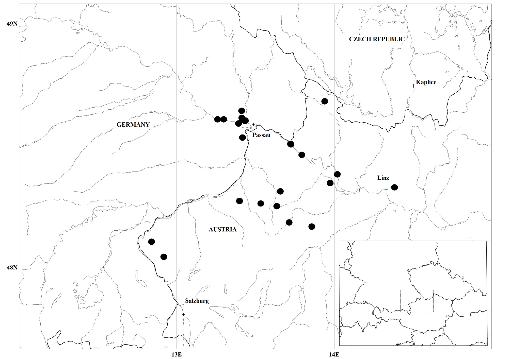
Distribution:— Rubus lentianus was found at sixteen localities in Austria (in the federal state of Upper Austria) and ten localities in Germany (Bavaria). There are two main distribution areas: (i) the valley of the Danube between Vilshofen an der Donau (Bavaria) and Linz (Upper Austria) and (ii) the regions Innviertel and Hausruckviertel in Upper Austria (Alpine Foreland) with occurrences in the hilly area south of Sauwald. In addition, there are scattered localities in the Weilhartforst near the border with the federal state of Salzburg and in the region Mühlviertel north of the Danube ( Fig. 4 View FIGURE 4 ). The distance between the two furthermost localities exceeds 130 km, so the species can be considered a regionally distributed bramble ( Kurtto et al. 2010). However, Rubus lentianus can be assumed to have a greater frequency and wider distribution in the southeastern part of Bavaria and Upper Austria. The species had probably been overlooked in the past because of its similarity with other species and singular biotypes of Rubus ser. Radula .
History of the discovery:—Vojtěch Žíla was the first to notice the species, as documented by his herbarium specimens stored in CB under two provisional names—‘ Rubus paraprogelopsis ’ and ‘ Rubus bobii ’, nom. invalid. in schedis. To our knowledge, the oldest records of the species documented by herbarium specimens come from 2004 and were collected by V. Žíla near the town of Grieskirchen and the village of Weibern in Upper Austria (CB).
Additional specimens examined (paratypes):— AUSTRIA. Upper Austria: Hintenberg (Rohrbach distr.), ca 1.2 km ESE of chapel in village, in scrub, one large growth, 730 m a.s.l., 48°40‘59.2“N, 13°56‘27.5“E, 15 August 2020, M. Lepší GoogleMaps & P. Lepší GoogleMaps s.n. ( CB 87544 ); Engelhartszell, in the big curve of the road nr. 136 above the village, forest fringes, 362 m a.s.l., 48°30‘24.1“N, 13°43‘33.9“E, 6 July 2020, Király & Hohla s.n. ( LI 862885 , barcode 03361467; LI 862886 barcode 03361474; herb. Király); Engelhartszell, in the big curve of the road nr. 136 above the village, forest fringes, 392 m a.s.l., 48°30’29.9”N, 13°43’24.9”E, 9 July 2021, Király & Hohla s.n. ( LI 862887 , barcode 03361481; LI 862888 , barcode 03361498; LI 862889 , barcode 03361504; herb. Király); Wesenufer, slope 0.2 km SW of the bridge at Niederranna, forest fringes, 326 m a.s.l., 48°27’48.9”N, 13°47’38.8”E, 6 July 2020, Király & Hohla s.n. ( LI 862882 , barcode 03361436; LI 862883 , barcode 03361443; LI 862884 , barcode 03361450; herb. Király); Krena, 0.6 km W of the village, along the road to Zell an der Pram GoogleMaps , 421 m a.s.l., 48°18’48.9”N, 13°39’29.9”E, 9 July 2021, Király & Hohla s.n. ( LI 862871 , barcode 03361320; LI 862872 , barcode 03361337); Urbs Linz, pagus Rienberg, margo silvae apud viam publicam, ad marginem merid. pagi, 300 m a.s.l., 48°20’50.3”N, 13°58’29.4”E, 12 August 2008, Žíla s.n. ( CB); Aschach a. d. Donau GoogleMaps , at the hydroelectric power station, fringes on the right bank of the river, 287 m a.s.l., 48°23‘01.3“N, 14°01‘12.4“E, 7 July 2020, Király & Hohla, s.n. ( LI 862880 , barcode 03361412; LI 862881 , barcode 03361429; herb. Király); Engerwitzdorf, Obertreffling, forest patch at the Alte Linzer Str, 425 m a.s.l., 48°19’49.4”N, 14°22’59.2”E, 5 July 2018, Király & Hohla s.n. (herb. Király); Ried im Innkreis GoogleMaps , Senftenbach, ca 1.5 km sz. od osady, 480 m a.s.l., 48°16’27.9”N, 13°23’58.3”E, 21 July 2006, M. Lepší, P. Lepší s.n. ( CB 51228 ); Andrichsfurt, forest E of the sports ground, 466 m a.s.l., 48°15’50.4”N, 13°32’05.6”E, 10 July 2021, Király & Hohla s.n. ( LI 863471 , barcode 03446805; LI 863472 , barcode 03446812); Schatzdorf, oppidum Riedau, pagus Schatzdorf, ad marginem silvae apud viam publicam, situ merid.-orient. a pago, 445 m a.s.l., 48°15’11.7”N, 13°38’08.7”E, 17 October 2004, Žíla s.n. ( CB); Tumeltsham, Walchshausen, road embankment, bushes, 453 m a.s.l., 48°14‘17.7“N, 13°30‘38.7“E, 11 August 2014, Hohla (obs. et photo); Tarsdorf, 2.8 km NE of the village, spruce plantations along the road to Hochburg-Ach, 493 m a.s.l., 48°06’24.5”N, 12°50’26.2”E, 7 July 2021, Király & Hohla s.n. ( LI 862890 , barcode 03361511; LI 862891 , barcode 03361528; herb. Király); Weibern, oppidum Haag am Hausruck GoogleMaps , pagus Weibern: ad marginem silvae, apud viam publicam, situ orient. a pago Weibern, 446 m a.s.l., 48°11’10.9”N, 13°42’50.0”E, 17 October 2004, Žíla s.n. ( CB); Wels, Kematen, okraj lesa již. od obce, 420 m a.s.l., 48°10’08.9”N, 13°51’29.3”E, 20 July 2006, M. Lepší & P. Lepší s.n. ( CB 51226 ); Franking, 0.3 km S of Eisengöring GoogleMaps , forest fringes, 433 m a.s.l., 48°02’43.2”N, 12°55’05.1”E, 7 July 2021, Király & Hohla s.n. ( LI 862892 , barcode 03361535; herb. Király). GERMANY. Bavaria: Otterskirchen, 0.7 km S of Stampfing, forest fringes on the left bank of the Danube GoogleMaps , 312 m a.s.l., 48°36’36”N, 13°17’59”E, 8 July 2020, Király & Hohla s.n. ( LI 862873 , barcode 03361344; LI 862874 , barcode 03361351; LI 862875 , barcode 03361368); Otterskirchen, 0.9 km W of Besensandbach GoogleMaps , forest fringes on the left bank of the Danube, 318 m a.s.l., 48°36‘32.4“N, 13°15‘38.5“E, 8 July 2020, Király & Hohla s.n. ( LI 862877 , barcode 03361382; LI 862878 , barcode 03361399; LI 862879 , barcode 03361405; herb. Király); Tiefenbach, 0, 3 km S of Alerting GoogleMaps , coniferous forests, 420 m a.s.l., 48°36’55.6”N, 13°24’50.7”E, 6 July 2018, Király & Hohla s.n. (herb. Király); Urbs Passau, pagus Patriching, margo silvae, ad marginem orient. [coordinates point to the western edge of Patriching village] pagi, 440 m a.s.l., 48°36’26.2”N, 13°24’59.7”E, 31 August 2008, Žíla s.n. ( CB, three specimens); Urbs Passau, pagus Ruderting, margo silvae apud viam publicam, ad marginem merid. pagi, 455 m a.s.l., 48°38’39.0”N, 13°24’46.6”E, 31 August 2008, Žíla s.n. ( CB, two specimens); Passau, 0.5 km E of Burgholz GoogleMaps , coniferous forests, 424 m a.s.l., 48°36’16.6”N, 13°25’42.6”E, 6 July 2018, Király & Hohla s.n. (herb. Király); Urbs Passau, pagus Patriching, margo silvae ad viam publicam, ca 1 km situ merid.-orient. a pago, 430 m a.s.l., 48°36’13.6”N, 13°25’46.9”E, 31 August 2008, Žíla s.n. ( CB, two specimens); Patriching ( Passau distr. GoogleMaps ), ca 1.4 km ENE of St. Korona church in village, edge of forest road, one large shrub, 420 m a.s.l., 48°36’14.1”N, 13°26’11.7”E, 5 September 2020, M. Lepší et al. s.n. ( CB 87508 ); Oppidum Passau, ad viam publicam trans oppidum Passau versus oppidum Regen. 48°35’33.2”N, 13°24’56.3”E, 2 October 1999, Žíla s.n. ( CB); Passau, 0.5 km NW of Wörth, shrubbery on the left bank of the Danube, 302 m a.s.l., 48°35‘31.2“N, 13°23‘35.5“E, 8 July 2020, Király & Hohla s.n. ( LI 862876 , barcode 03361375; herb. Király); Dommelstadl ( Passau distr. GoogleMaps ), ca 3.1 km NW of church in village, edge of forest road, one large shrub, 460 m a.s.l., 48°32’03.9”N, 13°25’06.2”E, 5 September 2020, M. Lepší et al. s.n. ( CB 87509 ).
Krahulcova, A., Travnicek, B. & Sarhanova, P. (2013) Karyological variation in the genus Rubus, subgenus Rubus: new data from the Czech Republic and synthesis of the current knowledge of European species. Preslia 85: 19 - 39.
Kurtto, A., Weber, H. E., Lampinen, R. & Sennikov, A. N. (eds.) (2010) Atlas Florae Europaeae. Distribution of vascular plants in Europe. 15. Rosaceae (Rubus). The Committee for Mapping the Flora of Europe & Societas Biologica Fennica Vanamo, Helsinki.
Travnicek, B., Lepsi, M., Lepsi, P. & Zila, V. (2018) Taxonomy of Rubus ser. Radula in the Czech Republic. Preslia 90: 387 - 424. https: // doi. org / 10.23855 / preslia. 2018.387
Weber, H. E. (1997) Untersuchungen zur Gattung Rubus im Chiemgau. Berichte der Bayerischen Botanischen Gesellschaft 68: 67 - 96.
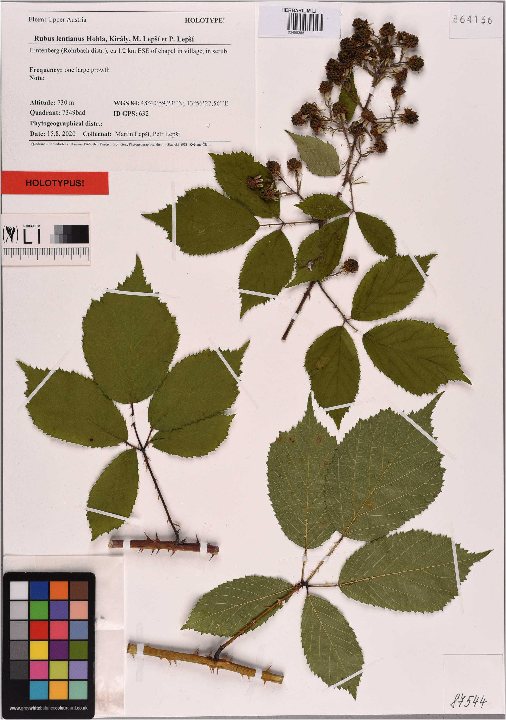
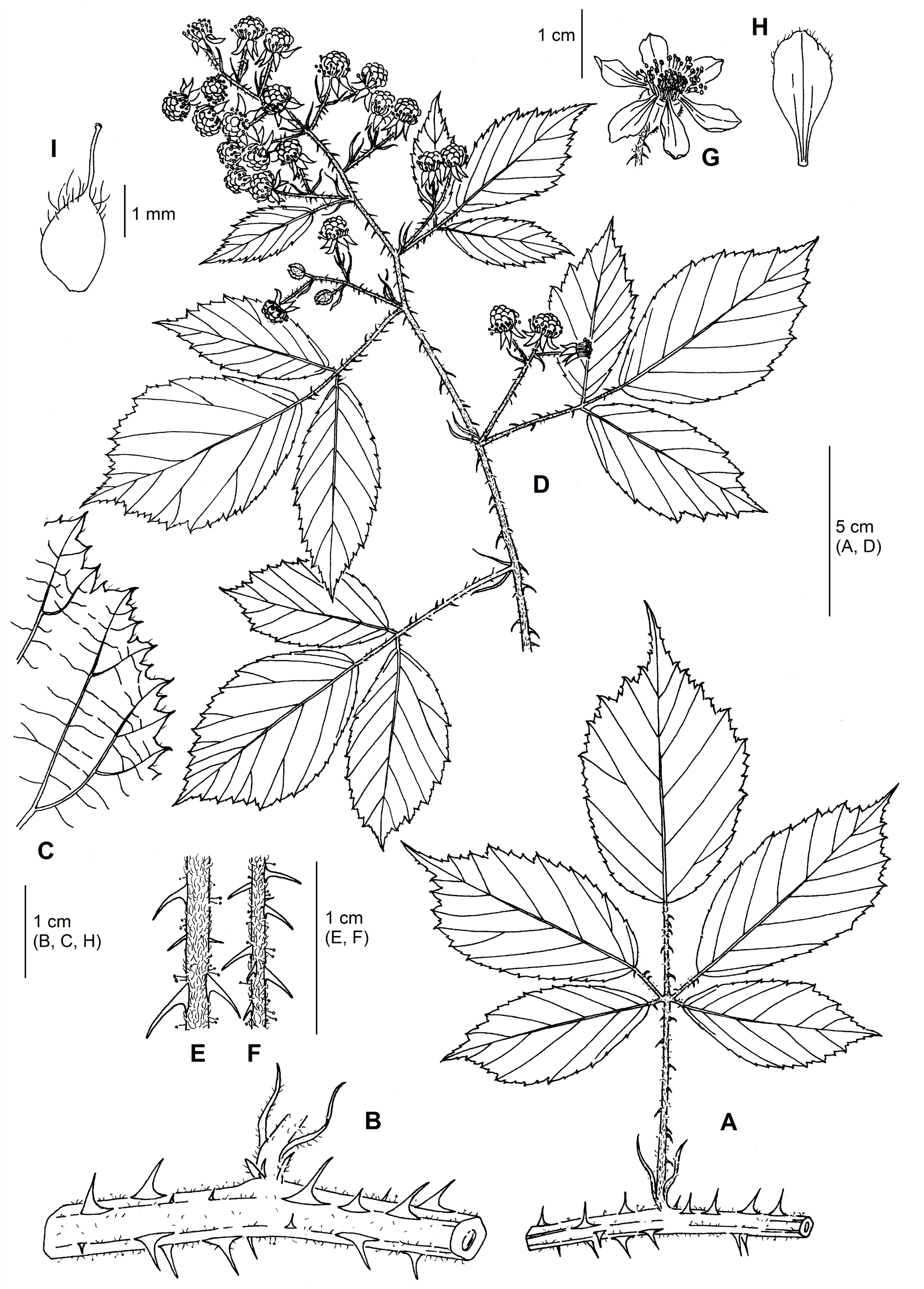
FIGURE 2.Rubus lentianus:A:section ofleafedfirst-year stem;B:detail of first-yearstem;C:marginofterminal leaflet;D:infructescence; E: inflorescence axis; F: peduncle; G: flower; H: petal; I: young carpel. Del. J. Táborská.
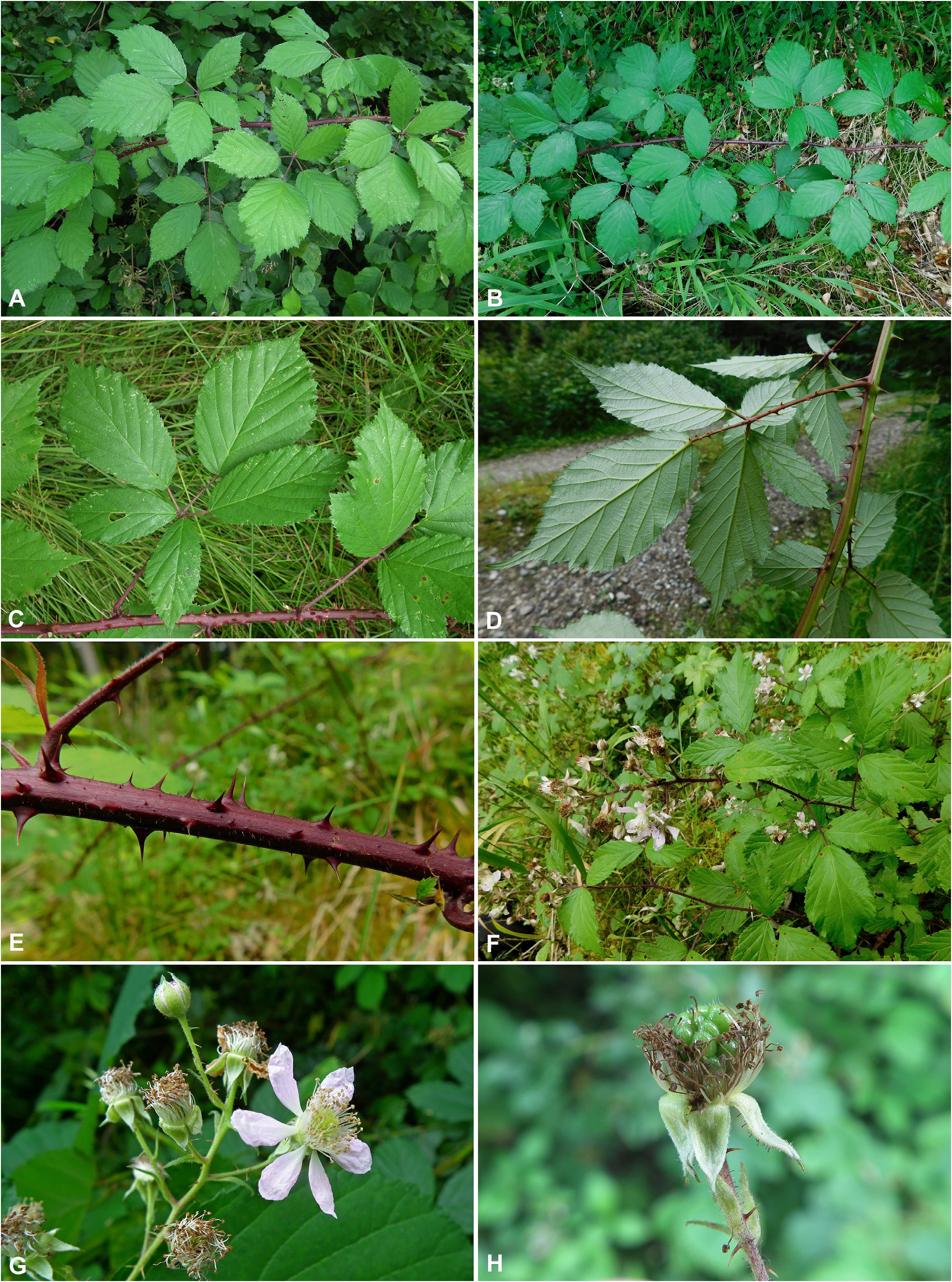
FIGURE 3. Rubus lentianus. A, B: middle section of first-year stem with leaves; C: leaf of first-year stem (upper side); D: leaf of first-year stem (lower side); E: section of first-year stem; F: inflorescence; G: part of inflorescence with a close-up of a flower; H: young collective fruit.Austria, Upper Austria, A–G: Tarsdorf, 7 July 2021, H: Aschach a. d. Donau, 7 July 2020, phot. G. Király.
| M |
Botanische Staatssammlung München |
| P |
Museum National d' Histoire Naturelle, Paris (MNHN) - Vascular Plants |
| W |
Naturhistorisches Museum Wien |
| CB |
The CB Rhizobium Collection |
| E |
Royal Botanic Garden Edinburgh |
| NE |
University of New England |
| S |
Department of Botany, Swedish Museum of Natural History |
No known copyright restrictions apply. See Agosti, D., Egloff, W., 2009. Taxonomic information exchange and copyright: the Plazi approach. BMC Research Notes 2009, 2:53 for further explanation.
|
Kingdom |
|
|
Phylum |
|
|
Class |
|
|
Order |
|
|
Family |
|
|
Genus |