
Ceroctis korana (Peringuey, 1886)
|
publication ID |
https://doi.org/ 10.11646/zootaxa.4373.1.1 |
|
publication LSID |
lsid:zoobank.org:pub:202AFD20-7B37-405A-9CBA-051EF24E9FB2 |
|
DOI |
https://doi.org/10.5281/zenodo.5990566 |
|
persistent identifier |
https://treatment.plazi.org/id/F72687E4-FFA4-FFF8-FF5F-F976FE614FBD |
|
treatment provided by |
Plazi |
|
scientific name |
Ceroctis korana |
| status |
|
Ceroctis korana species group
The validity of this heterogeneous assemblage, based only on phenetic similarities, needs confirmation. It is apparently endemic to the southwestern Africa.
Ceroctis amphibia ( Marseul, 1872) ( Fig. 3H View FIGURE 3 )
Mylabris (Ceroctis) amphibia Marseul, 1872
Ceroctis amphibia ssp. rudebecki Kaszab, 1956 Distribution. Western Angola and western Namibia View in CoL .
Material examined and literature records. [Kunene] Epupa: Ondundujengo River , 17.8000°S 12.3167°E ( SMWN) GoogleMaps ; S Omatjinguma , 17.8750°S 12.3750°E ( SMWN) GoogleMaps . Opuwo: 30 km WNW Oruoembe , 18.1167°S 12.3500°E ( SMWN) GoogleMaps ; Namib, Kakoveld, 15 miles S Anabib ( Orupenbe ), 18.1833°S 12.5167°E ( ssp rudebecki, Kaszab, 1956 ) GoogleMaps ; 100 miles W Ohopoho , 18.1833°S 12.5167°E ( Kaszab 1956). Sesfontein: Khowarib Schlucht GoogleMaps , 19.3000°S 13.9167°E (SMWN). Khorixas: N of Doros Crater, Skeleton Coast Park, 20.3667°S 14.1333°E (SMWN); 60 km Twyfelfontein , 20.5667°S 14.3667°E ( SMWN) GoogleMaps . [Erongo] Dâures: Brandberg Messum Valley , 21.2215°S 14.5163°E ( Bologna 2000a; CB; SMWN) GoogleMaps ; D2342, 9, 5 km S Messum Valley, 21.2999°S 14.5406°E (CB); D2342, 17 km SE Messum Valley GoogleMaps , 21.3048°S 14.6574°E (CB); D3716, Spitzkoppe, 21.8267°S 15.2074°E (CB); Spitskoppe, 21.8518°S 15.1484°E (SMWN). Karibib: B2, 16 km W Karibib, 21.9358°S 15.7056°E (CB); B2, 8 km W Usakos, 21.9876°S 15.5057°E (Bologna vidit); B2, 2, 6 km W Usakos GoogleMaps , 21.9989°S 15.5647°E (CB); Naob 69, 22.1333°S 15.5667°E (SMWN); B2, 56 km W Usakos , 22.1763°S 15.1722°E (CB). Arandis: 6 km N Arandis GoogleMaps , 22.3667°S 14.9833°E (SMWN); Rossing Mine , 22.4667°S 15.0333°E ( SMWN) GoogleMaps ; Lower Dome Gorge , 22.4667°S 15.0667°E ( SMWN) GoogleMaps ; Upper Ostrich Gorge , 22.4833°S 14.9833°E ( SMWN) GoogleMaps ; Upper Panner Gorge , 22.4833°S 15.0167°E ( SMWN) GoogleMaps ; Lower Ostrich Gorge , 22.5000°S 14.9667°E ( SMWN) GoogleMaps . [Hardap] Gibeon: Waltevrede G. Farm , 24.1779°S 15.9802°E (CB); C14 10 km S Waltevrede GoogleMaps , 24.2377°S 15.9040°E (CB). [Karas] Keetmanshoop Rural: Khabus 146 GoogleMaps , 26.3000°S 18.2167°E (SMWN).
Other records: Namib Sand Sea desert ( Seely 2012); Namibia ( Bologna 2000a; Pitzalis et al. 2014).
Remarks. Types of this species were examined at MNHN.
The taxonomy of this species was discussed by Bologna (2000a), who synonymized the ssp. rudebecki Kaszab, 1956 with the nominate form.
The phylogenetic position of C. amphibia is unclear, but we suggest possible relationships with C. korana and C. karrooensis , due to the common shape of the wide pronotum with similar puncturation, and the similar shape of antennomeres. Actually, C. amphibia is well distinct from the remaining species at least because of the partial red colour of femours.
Ceroctis karroensis Péringuey, 1909 ( Fig. 3I View FIGURE 3 )
Distribution. Namibia and western South Africa.
Material examined and literature records. [Kunene] Epupa : Okakatuwo, Kaokoland, 17.4000°S 12.7333°E ( SMWN) GoogleMaps . [Omusati] Okahao: C35, Kamanjab-Ruacana 77 km NW of Kamanjab, 19.2528°S 14.4442°E (CB). [Khomas] Windhoek Rural: Windhoek, D 1535, 5 km jct. B6, 22.3681°S 17.6675°E (CB); C23, 26 km S Dordabis, 23.0575°S 17.9329°E (CB); Solitaire, 23.8648°S 16.0585°E (CB). [Omaheke] Steinhausen: Kehoro Noord 185, 21.9667°S 18.7167°E ( SMWN) GoogleMaps . Aminius: C20, Gobabis-Leonardville 5 km S Aais, 23.2593°S 18.7237°E (CB). [Hardap] Gibeon: C14, Maltahohe-Bullsport, after Fish River GoogleMaps , 24.4022°S 16.8172°E (CB). [Karas] Keetmanshoop Urban: C16, Keetmanshoop, 6 km jct. B1, 26.5809°S 18.1925°E (CB). Lüderitz: near Aus, 26.6667°S 16.2667°E (CB); Obib Mts. / Dunes, Diamond Area 1, 28.0500°S 16.6000°E ( SMWN) GoogleMaps . Keetmanshoop Rural: Karas distr., 27.1352°S 19.4941°E (CB); Namaqualand, Rek Vlatke, 27.4000°S 16.5833°E ( Kaszab 1955b, as ab. bisbiinterrupta). Oranjemund : Boom River Canyon, 19 km N of Orange River (ESE of Rosh Pinah ), 27.8667°S 17.0667°E ( SMWN) GoogleMaps .
Other records: Namibia ( Bologna 2000a; Pitzalis et al. 2014). Kaszab (1955b as ab. bisbiinterrupta) cited the species from southern Kalahari, but probably this record refers to the South African portion of this desert.
Remarks. Types of this species were examined at SAMC.
The elytral pattern is variable, due to the extension of the black colouration. Orange-yellow spots are usually estended and partially coalescent, forming transverse irregular fasciae. Small and round spots without fasciae are present in few specimens (E of Windhoek, Diamond Area, Boom River; South Africa, Richtersveld), which appear distinct from the most common phenotype. Male antenna, pronotum and male genitalia are illustrated in Figs 11 View FIGURE 11 A- E.
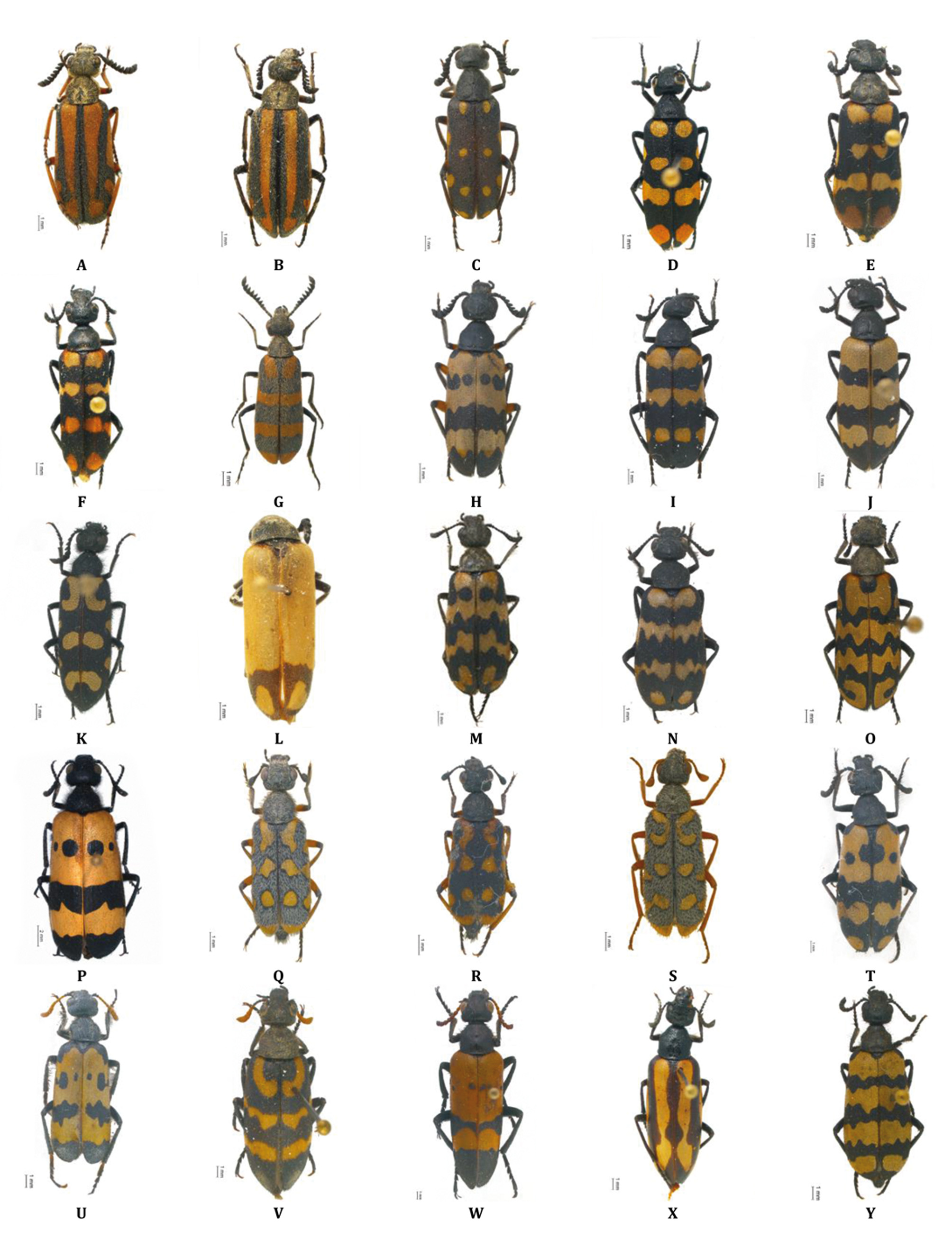
Ceroctis korana ( Péringuey, 1886) ( Fig. 3J View FIGURE 3 )
Mylabris korana Péringuey, 1886
Distribution. Western Namibia (new species record for this country) and western South Africa.
Material examined. [Hardap] Gibeon: C19, 8 km S Solitaire, 23.9774°S 16.0063°E (CB); Waltevrede G. Farm, 24.1779°S 15.9802°E (CB); Gorraris 99, Luderitz , 25.3184°S 15.9089°E ( SMWN) GoogleMaps . [Karas] Lüderitz: Awasib, dunes E, 25.2500°S 15.7167°E ( SMWN) GoogleMaps ; Numabis Pan Diamond Area 2, 25.5167°S 15.5167°E ( SMWN) GoogleMaps . Keetmanshoop Rural: Khabus 146, 26.2833°S 18.2333°E (SMWN); Khabus 146, 26.3000°S 18.2167°E (SMWN). Berseba: C14, 51 km N Bethanienm, 26.2919°S 17.0535°E (CB); B4, 73 km W Keetmanshoop, 26.7809°S 17.4657°E (CB); 15 km ESE of Goageb GoogleMaps , 26.8000°S 17.3667°E (SMWN). Oranjemund: C13, 50 km S Rosh Pinah, 28.07076°S 17.12799°E (CB); C13, 25– 30 km S Rosh Pinah GoogleMaps , 28.07315°S 16.94231°E (CB). Karasburg: M21, 4 km N Warmbad, 28.39832°S 18.75766°E (CB); C13, 44, 5 km N Noordoewer Grape Valley GoogleMaps , 28.41803°S 17.44408°E (CB); C10, 23 km N Velloorsdrif, 28.52194°S 19.18402°E (CB); Noordoewer, 28.6667°S 17.6667°E (SMWN); Noodoewer, 28.7500°S 17.6167°E (SMWN).
Other records. Namib Sand Sea desert ( Seely 2012); Namibia ( Pitzalis et al. 2014) .
Remarks. Types of this species were examined at SAMC.
This species is similar to C. karrooensis , but distinct because of the following characters: shiny integuments, deeper and more distanced punctures of head and pronotum, male antennomeres IV–IX less serrate, wider extension of lemon yellow colouration, particularly on the fore fascia.
We suspect that C. gariepina (Péringuey, 1888) from northwestern South Africa could represent only an elytral variation of C. korana .

| SMWN |
State Museum |
No known copyright restrictions apply. See Agosti, D., Egloff, W., 2009. Taxonomic information exchange and copyright: the Plazi approach. BMC Research Notes 2009, 2:53 for further explanation.
|
Kingdom |
|
|
Phylum |
|
|
Class |
|
|
Order |
|
|
Family |
|
|
SubFamily |
Meloinae |
|
Tribe |
Mylabrini |
|
Genus |
Ceroctis korana
| Bologna, Marco A., Amore, Valentina & Pitzalis, Monica 2018 |
Ceroctis amphibia ssp. rudebecki Kaszab, 1956
| , Kaszab 1956 |
Ceroctis karroensis Péringuey, 1909
| Peringuey 1909 |
Mylabris korana Péringuey, 1886
| Peringuey 1886 |
Mylabris (Ceroctis) amphibia
| Marseul 1872 |