
Dasysyrphus limatus (Hine)
|
publication ID |
https://doi.org/ 10.11646/zootaxa.3660.1.1 |
|
publication LSID |
lsid:zoobank.org:pub:95ADD39C-98BE-4879-B070-34A5D86BD67B |
|
persistent identifier |
https://treatment.plazi.org/id/03893F32-FF99-FF8C-FF46-FBD8FC6F8A6B |
|
treatment provided by |
Felipe |
|
scientific name |
Dasysyrphus limatus (Hine) |
| status |
|
Dasysyrphus limatus (Hine) View in CoL
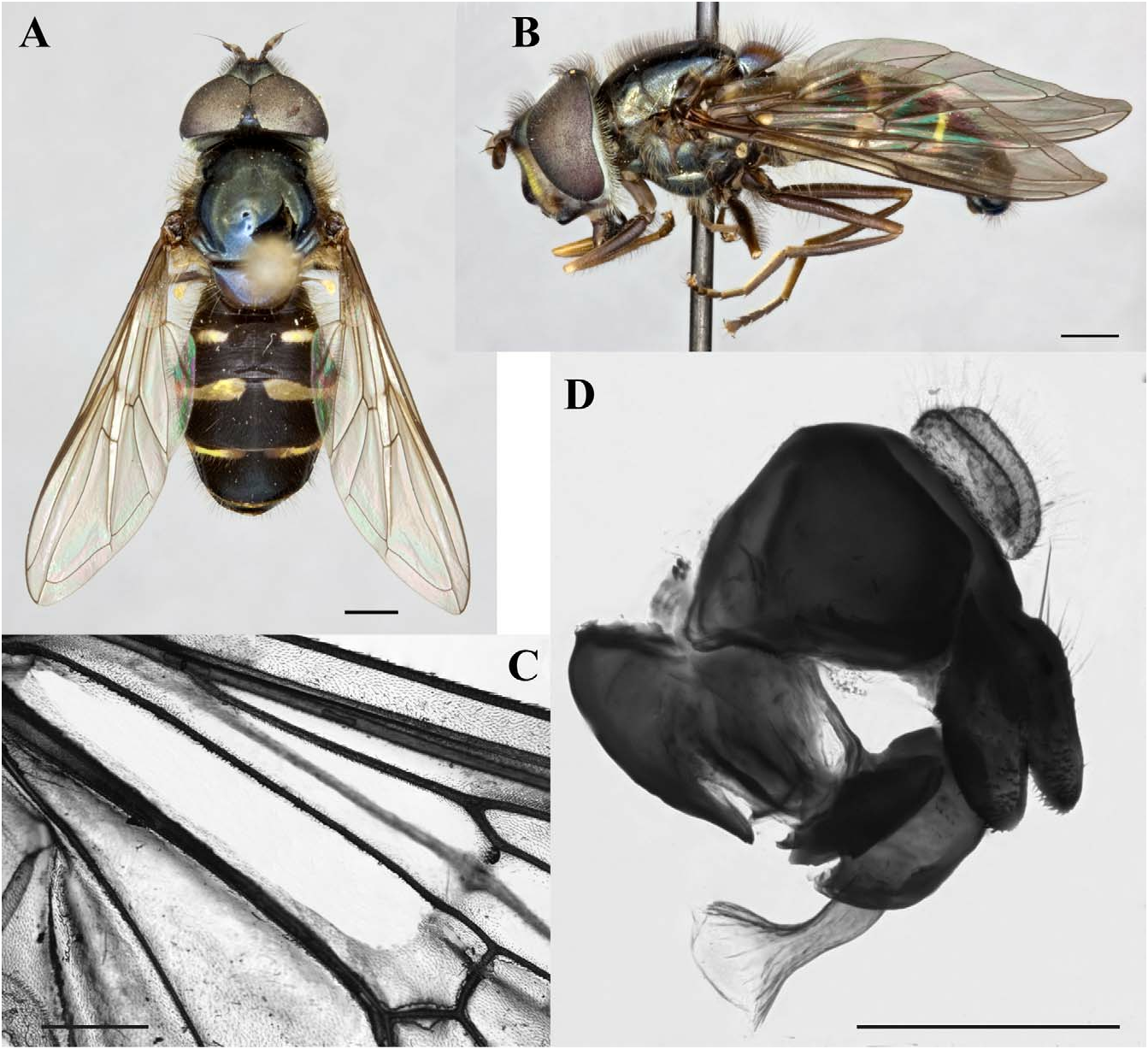
Figures: 9A–D, 20D
Synonyms and References:
Syrphus limatus Hine 1922: 146 View in CoL (original description)
Curran 1925: 178, Pl. XI Fig. 154 (redescription)
Fluke 1933: 114 (key, redescription and transfer to Metasyrphus )
Stone et al. 1965: 563 (catalogue and transfer to Dasysyrphus )
Vockeroth 1986: 202 (lectotype designation)
Vockeroth 1992: 66 (key and redescription)
Diagnosis: Abdominal maculae cross abdominal margin; maculae on tergite 2 very small oval-shaped; maculae on tergites 3&4 transverse, narrow and slightly widened medially, narrow slightly towards margin ( Fig. 9A View FIGURE 9 ). Similar to D. venustus ( Fig. 17A View FIGURE 17 ) however the maculae on tergite 2 are always small in D. limatus , less than ¼ the width of the tergite, and are much larger in D. venustus , greater than ⅓ the width of the tergite.
Redescription:
Body Length: 7.5–10.9mm; Wing Length: 6.8–10.4mm
Head: Frons dark with light pollenose fascia (in males it runs along ventral edge of where eyes meet, in female it is ½ or less the length between the antennae and ocelli, with a distinct separation medially) and dark pile; face light with dark vitta ⅓–½ the width of the face and reaches the antennal socket, face with dark pile, bare medially; gena dark with some light pollen ventral to eye, light and dark pile; occiput dark, covered in light pollen, pile light, some specimens with some dark pile; scape, pedicel and flagellomere dark.
Thorax: Scutum dark, may appear shiny or metallic, pile dark in males and light in female; scutellum light to dark with darker lateral edges, pile dark with some light pile along lateral edges to light with some dark on posterior edge; wing cell br bare basally and above spurious vein, bm bare on anterior ½–¾, r 1 bare at base and some with cup bare posterior to vein CuP ( Fig. 9C View FIGURE 9 ); haltere light; pro- and mesofemora dark on basal half, light on apical half, metafemur dark with light apical end, pro- and mesotibiae light, metatibia dark with light basal end, tarsi dark, pro- and mesotarsi with light ventral side.
Abdomen: Maculae on tergite 2 small, slender and oval, <¼ width of tergite, maculae on tergites 3&4 are transverse, slender and widen medially, narrowed toward margin, positioned anteriorly on the tergite, maculae cross abdominal margin ( Fig. 9A View FIGURE 9 ); sternites light with thick, dark fasciae.
Male Genitalia: Surstylus more or less oval in shape in lateral view, flattened with long pile on posterior side and spines on anteroventral side; cercus oval with long pile over entire surface; gonostylus triangular-shaped in lateral view, wide at base and elongated posterodorsal with small pointed projection on posterodorsal edge, posterior edge flares laterally, making it difficult to see in lateral view; pile on dorsal surface; basiphallus is greatly enlarged dorsally, fully sclerotized all the way around with no pile or spines; distiphallus is short with no enlarged area basally, apical end flared out into horn, which is mostly sclerotized but membranous at apex with no setulae dorsally ( Fig. 9D View FIGURE 9 ).
Intraspecific variation: Maculae on abdomen can be of varying thickness, however they are usually quite narrow.
Etymology: The word limatus is Latin, meaning polished, refined.
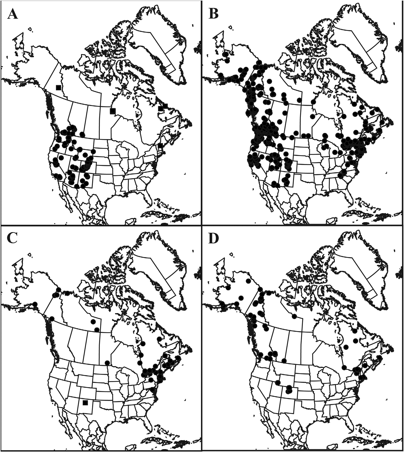
Distribution: Canada (AB, BC, NT, NS, QC, YT), USA (AK, CO, MA, ME, NY, UT) ( Fig. 20D View FIGURE 20 )
Ecology: Collected on common cow parsnip ( Heracleum maximum ). Collected from “sand dunes” and “outlet marsh” habitats. Collected April to September, although much more frequently collected from June through August. Collected from elevations of 320m – 3002m.
Discussion: The concept of limatus has been applied consistently since Hine erected the name in 1922.
Type Material: “Savonoski/ Naknek Lake / Alaska / July ‘19”, “ Jas. S. Hine / Collector”, red label “ Allotype ”, yellow label “ PARALECTOTYPE / Syrphus / limatus/ Hine”, barcode label “ OSUC 0373263 View Materials ”; ♂ ; deposited in the Ohio State University Collection ( OSU). (examined)
Material Examined:
Paralectotype: United States of America: Alaska: Savonoski. Naknek Lake , [58.497288, -155.266794], vii.1919, ♀, OSUC 319689 View Materials GoogleMaps , Jas. S. Hine ( OSU); vii.1919, ♂, CNCD 87874 , J. S. Hine ( CNC) . Other Material Examined: Canada: Alberta: BANFF NATIONAL PARK : Sulphur Mountain , [51.149438, -115.583484], 2195m, 28.vii.1967, ♀, CNCD 13699 GoogleMaps , J. R. Vockeroth ( CNC); Banff , [51.180275, -115.568433], 9.vi.1922, ♂, CNCD 13647 GoogleMaps , C.B.D. Garrett ( CNC); Mile 14 Banff-Jasper Highway , [51.231247, -115.838509], 3.viii.1955, ♀, CNCD 13686 , R GoogleMaps . Coyles ( CNC); Snow Creek Pass , [51.60524, -115.808617], 2256m, 28.vii.1962, ♀, CNCD 13687 GoogleMaps , W. R. M. Mason ( CNC) . British Columbia: Vaseux L. Hills to E, [49.316685, -119.523082], 2.v.1983, ♂, JSS 20038, S.G. Cannings ( UBCZ). CENTRAL KOOTENAY GoogleMaps L.D.: Robson , [49.333015, -117.692871], 6.v.1958, ♂, RBCM ENT 99188122 View Materials GoogleMaps , 11.v.1966, ♂, Royal British Columbia M ENT 99188124, H. R . Foxlee ( RBCM); 12.v.1956, ♂, JSS 20040, 17.vii.1955, ♀, JSS 20041, 28.iv.1958, ♀, JSS 20043, 12.ix.1952, ♀, JSS 20044, 13.v.1967, ♂, JSS 20088, 22.v.1956, ♂, JSS 20108, 27.vii.1959, ♂, JSS 20129, H. R . Foxlee ( UBCZ); 15.v.1948, ♂, CNCD 13656 , 11.v.1948, 2♂, CNCD 13657 , 14473 , H. R. Foxlee ( CNC). Squamish, Diamond Head Trail , [49.811126, -123.07434], 975m, 9.viii.1953, ♀, CNCD 13683 GoogleMaps , G.J. Spencer ( CNC). MOUNT REVELSTOKE NATIONAL PARK : Mt. Revelstoke , [50.98333333, -118.2], 1.viii.1952, ♀, CNCD 533 , G.P. Holland ( CNC); 13.viii.1952, ♀, CNCD 48545 , G. J. Spencer ( CNC); Mount Harry , [51.035979, -118.142509], 1890m, 20.vii.1952, ♀, CNCD 13682 GoogleMaps , G.J. Spencer ( CNC). CASSIAR L.D.: Moosehorn Lake , [58.164009, -132.12694], 1372m, 1.viii.1960, ♀, CNCD 13678 GoogleMaps , W.W. Moss ( CNC); 1372m, 30.vii.1960, ♀, CNCD 13679 , R . Pilfrey ( CNC). NORTHERN ROCKIES R . D.: Summit Lake, Mile 392 of Alaska Highway , [58.648201, -124.666912], 1280m, 21.vii.1959, ♀, CNCD 13680 GoogleMaps , 15.vii.1959, ♀, CNCD 13681 , R . E. Leech ( CNC). Liard R . hotsprings, [59.425991, -126.096398], 23.vii.1987, ♀, JSS 20046, S.G. Cannings ( UBCZ). Atlin, [59.5775, -133.69236],.viii., ♀, CNCD 13684 , ( CNC). Campbell Mtn., Pentiction , 880m, 13.v.1983, ♂, JSS 20039, S.G. Cannings ( UBCZ). Northwest Territories : Muskox Lake , [64.633135, -108.249285], 20.vii.1953, ♂, CNCD 13645 GoogleMaps , J.G. Chillcott ( CNC). 21 miles east Tuktoyaktuk , [69.426844, -132.172475], 2–5.vii.1971, ♂, CNCD 13646 GoogleMaps , 20–25.vi.1971, ♀, CNCD 13694 GoogleMaps , D.M. Wood ( CNC). Nova Scotia: CAPE BRETON HIGHLANDS NATIONAL PARK : Mackenzie Fire Tower , [46.773977, -60.818772], 8.vii.1983, ♂, CNCD 13665 GoogleMaps , D.M. Wood ( CNC). Quebec: Cté Missisquoi summit Mt Pinacle , [45.018184, -72.855064], 700m, 20.vi.1991, ♂, JSS 20795, D.M. Wood ( CNC). BROME- MISSISQUOI: Knowlton , [45.216716, -72.514769], 12.vi.1928, ♀, CNCD 13651 GoogleMaps , W.J. Brown ( CNC). Summit of Mt. Rigaud , [45.46638889, -74.32638889], 4.vi.1978, 4♂, CNCD 5809 , 13659–13661 GoogleMaps , D.M. Wood ( CNC). LA VALLEE- DU- RICHELIEU: Mont Saint-Hilaire , [45.552948, -73.155276], 17.vi.1965, ♂, CNCD 13667 GoogleMaps , 27.vi.1965, 4♂, CNCD 13668–13671 GoogleMaps , J.W. Boyes ( CNC). TEMISCAMINGUE: Laniel , [47.045828, -79.268979], 10.vi.1931, ♀, CNCD 13688 GoogleMaps , H.S. Fleming ( CNC). Sakami ( LG3 ), [53.71666667, -76.06666667], 13–18.vii.1977, 2♂, CNCD 5808 , 13658 GoogleMaps , D.M. Wood ( CNC). Lac Duplanter, Lac Delorme , [54.883534, -69.78209], 7–12.vii.1977, 3♂, CNCD 13662–13664 GoogleMaps , D.M. Wood ( CNC). Kuujjuaq ( Fort Chimo ), [58.100076, -68.406179], 28.vii.1948, 2♀, CNCD 13689 , 13690 , R GoogleMaps . H. MacLeod ( CNC). Yukon Territory: Carcross , [60.186691, -134.692703], 16–18.vi.1982, ♂, CNCD 13666 GoogleMaps , G. & M. Wood ( CNC). Whitehorse , [60.733402, -135.082092], 22.vii.1959, ♀, CNCD 13698 , R GoogleMaps . Madge ( CNC). Haines Jct., [60.752472, -137.510006], 29.vi.1974, ♀, JSS 20181, G.G.E. Scudder ( UBCZ). Otter Lake , [62.486817, -130.4166667], 1219m, 28.vii.1960, ♀, CNCD 13650 GoogleMaps , 29.vii.1960, ♀, CNCD 13696 GoogleMaps , E.W. Rockburne ( CNC). Sheldon Lake , [62.616763, -131.266603], 1067m, 3.vii.1960, ♂, CNCD 13654 GoogleMaps , E.W. Rockburne ( CNC); 3.vii.1960, ♀, CNCD 13915 , 7.vii.1960, ♂, CNCD 13655 , ♀, CNCD 13695 , J.E.H. Martin ( CNC). La Force Lake , [62.683333, -132.333333], 1006m, 27.vi.1960, ♂, CNCD 14010 GoogleMaps , J.E.H. Martin ( CNC). Borth Fork Pass , [64.51666667, -138.2166667], 1067m, 27.vii.1982, ♀, JSS 20045, S.G. Cannings, L. Vasington, R GoogleMaps . A. Moore ( UBCZ). North Fork Crossing, Mile 43 Peel Pit Road , [64.565983, -138.250648], 1067m, 6.vii.1962, ♂, CNCD 13652 , R GoogleMaps . E. Leech ( CNC); 3.vii.1962, ♂, CNCD 13653 , 7.vii.1962, ♀, CNCD 13697 , P.J. Skitsko ( CNC). DEMPSTER HIGHWAY: km 82, [64.581259, -138.261721], 1300m, 20.vii.1981 21.vii.1981, ♀, CNCD 13685 GoogleMaps , Lafontaine and G. & M. Wood ( CNC); Mile 87, [65.054721, -138.128324], 27–30.vi.1973, ♂, CNCD 13649 GoogleMaps , 5–7.vii.1973, ♀, CNCD 13691 GoogleMaps , 16–17.vii.1973, ♀, CNCD 13693 , 4–8.viii.1973, ♀, CNCD 13692 , G. & D.M. Wood ( CNC); km 416, [66.644581, -136.324471], 750m, 22–28.vi.1980, 3♂, CNCD 13675–13677 GoogleMaps , Wood & Lafontaine ( CNC); km 465, [67.046392, -136.209668], 800m, 5–7.vii.1980, ♂, CNCD 13674 GoogleMaps , Wood & Lafontaine ( CNC). Richardson Mts , [66.04166667, -135.5333333], 1219m, 6.vii.1982, ♂, CNCD GoogleMaps 5810, 762m, 7.vii.1982, 3♂, CNCD 532 , CNCD 13672 , 13673 , D.M. Wood ( CNC). British Mts. , [69.21666667, -140.0833333], 320m, 21.vi.1984 26.vi.1984, ♀, JSS 20774, G. & M. Wood & D. Lafontaine ( CNC) GoogleMaps . United States of America: Alaska: Katmai , [58.033889, -154.876944], viii.1917, ♀, CNCD 112302 GoogleMaps , J. S. Hine ( CNC). BRISTOL BAY CO.: Savonoski, Naknek River , [58.716814, -156.865366], vii.1919, ♂, JSS 19479, ♀, JSS 19478, J.S. Hine ( CNC). MATANUSKA- SUSITNA CO GoogleMaps .: Matanuska , [61.541945, -149.229674], vii.1944, 3♀, JSS 19483, 19484, 19489, J. Chamberlin ( CNC); vii.1944, ♀, OSAC 133385 View Materials GoogleMaps , J. Chamberlin ( OSAC). DENALI CO .: Healy, [63.845424, -149.013681], 26.vi.1921, ♀, JSS 19485, 27.vi.1921, ♂, JSS 19524, J.M. Aldrich ( CNC). Unalakleet , [63.86666667, - 160.7833333], 8.viii.1961, ♀, CNCD 112193 GoogleMaps , 9.viii.1961, ♀, CNCD 112194 GoogleMaps , 15.viii.1961, ♀, CNCD 26574 , B.S. Heming ( CNC). Umiat , [69.36666667, -152.1333333], 6.vii.1959, ♀, CNCD 26579 GoogleMaps , J.E.H. Martin ( CNC) . Colorado: LAKE COUNTY : Tennessee Pass, [39.357246, -106.313889], 24.vii.1917, ♀, JSS 19490, J.M. Aldrich ( CNC). Loveland Pass, Western Slope , [39.65, -105.8666667], 3002m, 28.vii.1961, 2♂, CNCD 26385 , 26386 GoogleMaps , J.G. Chillcott ( CNC). CLEAR CREEK CO .: Doolittle Ranch, Mt. Evans , [39.675739, -105.601348], 2987m, 23.vii.1961, ♂, CNCD 26383 GoogleMaps , B.H. Poole ( CNC); 8.vii.1961, ♀, CNCD 111622 , 22.vii.1961, ♂, CNCD 26384 , 11.viii.1961, ♀, CNCD 112192 , W. R. M. Mason ( CNC); 23.vii.1961, ♀, CNCD 35315 , J.G. Chillcott ( CNC). Chambers Lake, [40.603663, -105.853645], 3.ix.1932, ♂, JSS 20739, ( CSUC). North Park, [40.73, -106.18], 1.vii.1932, ♀, JSS 20733, ( CSUC). Glendevey , [40.8078, -105.935501], 7.vii.1931, ♀, JSS 20741, C. R GoogleMaps . Jones ( CSUC) . Maine: PISCATAQUIS CO .: Mount Katahdin , [45.904968, -68.921017], 5.vii.1958, ♂, JSS 19481, ( CNC) GoogleMaps . Massachusetts: NORFOLK CO .: Wellesley Hills , [42.308427, -71.278693], 1963, ♀, JSS 19482, D. Meissner ( CNC). HAMPSHIRE CO GoogleMaps .: Amherst , [42.34038, -72.496818], 15.v.1963, ♀, JSS 19486, S. T GoogleMaps . William ( CNC); 8.v.1965, ♀, JSS 19487, Mansfield ( CNC); 8.v.1965, ♂, JSS 19488, B. Scott ( CNC); 6.v.1973, ♂, USNM ENT 258065 View Materials , A. Lavallee ( USNM) . New York: ESSEX CO .: Mount MacIntyre Summit , [44.132434, -74.007381], 26.vi.1941, ♂, CNCD 26387 GoogleMaps , H. Dietrich ( CNC); Mount Hurricane , [44.233601, -73.708728], vi.1939, ♂, JSS 19480, R GoogleMaps . C. Shannon ( CNC) . Utah: CACHE CO .: Cowley Canyon, [41.772669, -111.60407], 10–17.viii.1989, JSS 25132, W.J. Hanson ( EMUS); Logan Cyn., Turner Campground , [41.85, -111.5666667], 2.vii.2003 6.vii.2003, ♀, JSS 24607, W.J. Hanson & Brammer ( EMUS); Tony Grove Creek , [41.886599, -111.564102], 29.vi.–8.vii.1994, ♂, JSS 24610, 8– 15.vii.1994, JSS 24608, 25121–25124, 25127, 15–26.vii.1994, JSS 25128, 4–12.viii.1994, JSS 25131, 12– 19.viii.1994, JSS 24609, 25125, 25126, 25129, 25130, W.J. Hanson ( EMUS); West Hodges Canyon , [41.910305, - 111.42277], 8.viii.1978 11.viii.1978, JSS 25133, Hanson, Knowlton ( EMUS) GoogleMaps .

| OSU |
Oklahoma State University, Collection of Vertebrates |
| CNC |
Canadian National Collection of Insects, Arachnids, and Nematodes |
| R |
Departamento de Geologia, Universidad de Chile |
| UBCZ |
University of British Columbia, Spencer Museum |
| RBCM |
Royal British Columbia Museum |
| CO |
Museum National d'Histoire Naturelle |
| OSAC |
Oregon State Arthropod Collection |
| CSUC |
California State University, Chico, Vertebrate Museum |
| T |
Tavera, Department of Geology and Geophysics |
| USNM |
Smithsonian Institution, National Museum of Natural History |
No known copyright restrictions apply. See Agosti, D., Egloff, W., 2009. Taxonomic information exchange and copyright: the Plazi approach. BMC Research Notes 2009, 2:53 for further explanation.
|
Kingdom |
|
|
Phylum |
|
|
Class |
|
|
Order |
|
|
Family |
|
|
Genus |
Dasysyrphus limatus (Hine)
| Locke, Michelle M. & Skevington, Jeffrey H. 2013 |
Syrphus limatus
| Hine, J. S. 1922: 146 |