
Anguillosyllis inornata, Maciolek, 2020
|
publication ID |
https://doi.org/ 10.11646/zootaxa.4793.1.1 |
|
publication LSID |
lsid:zoobank.org:pub:550F8461-03F6-4301-8791-605775D77467 |
|
persistent identifier |
https://treatment.plazi.org/id/F0EBF406-A394-4CCA-9108-D2FEEC36B70F |
|
taxon LSID |
lsid:zoobank.org:act:F0EBF406-A394-4CCA-9108-D2FEEC36B70F |
|
treatment provided by |
Plazi |
|
scientific name |
Anguillosyllis inornata |
| status |
sp. nov. |
Anguillosyllis inornata View in CoL n. sp.
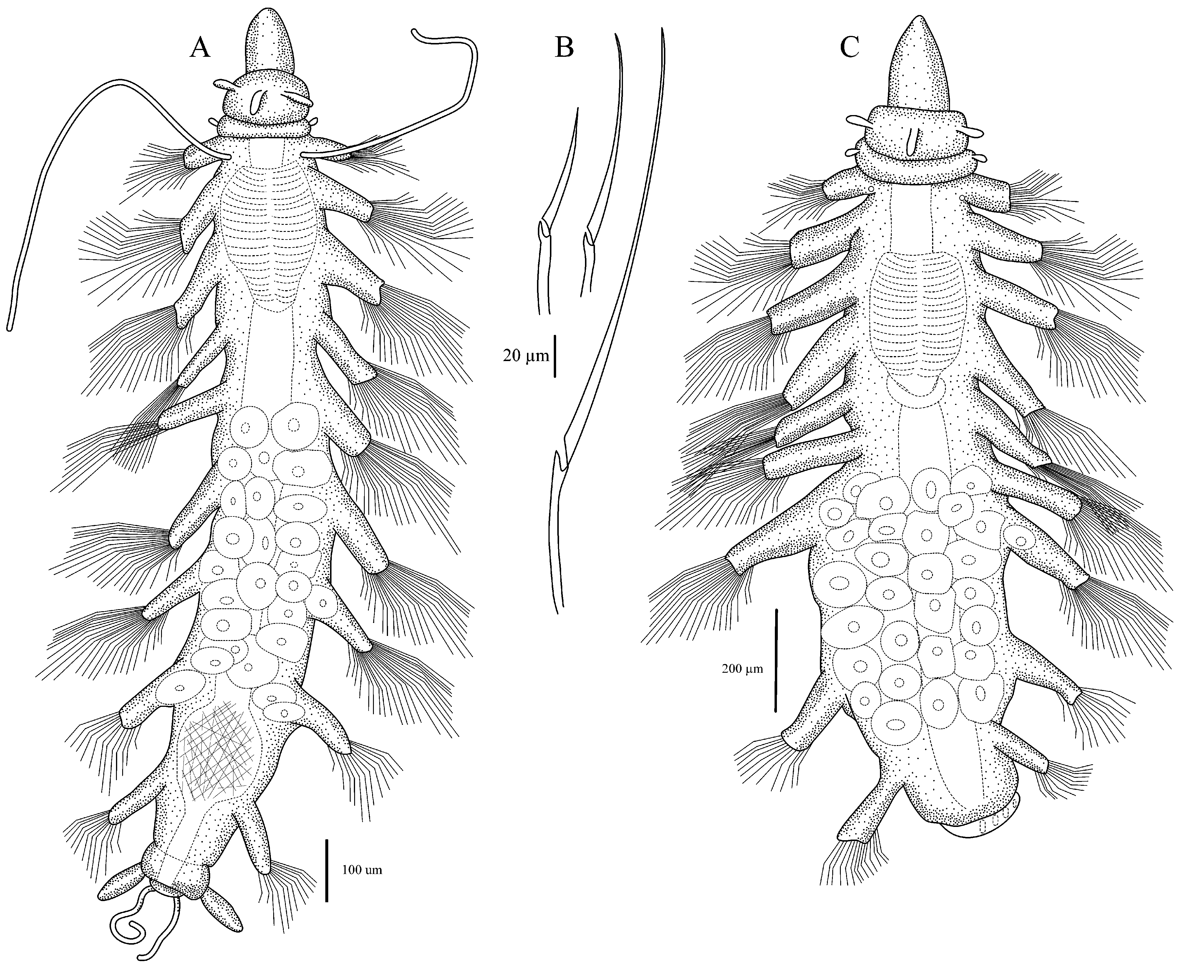
Figures 31–32 View FIGURE 31 View FIGURE 32
urn:lsid:zoobank.org:act:F0EBF406-A394-4CCA-9108-D2FEEC36B70F
Braniella View in CoL sp. 1: Blake et al. 2009: 1797.
Material examined. (424 specimens from 25 stations, 100 samples). Gulf of the Farallones , California continental slope. US Navy Survey, 103 Site Selection Survey , west of the Farallon Islands , coll. J.A. Blake, Sta. B 1, 18 Jul 1991, 37 o 39.64ʹN, 123 o 30.02ʹW, 2955 m, 3 specimens ( CASIZ 229826 ) GoogleMaps ; Sta. B 2, 19 Jul 1991, 37 o 40.36ʹN, 123 o 27.96ʹW, 2701 m, 2 specimens ( CASIZ 229822 ) GoogleMaps ; Sta. B 3, 20 Jul 1991, 37 o 40.06ʹN, 123 o 23.69ʹW, 2385 m, 4 specimens ( CASIZ 229828 ) GoogleMaps ; Sta. B 4, 20 Jul 1991, 37 o 38.46ʹN, 123 o 30.07ʹW, 3055 m, 2 specimens ( CASIZ 229823 ) GoogleMaps ; Sta. B 5, 20 Jul 1991, 37 o 38.94ʹN, 123 o 28.81ʹW, 2925 m, 1 specimen ( CASIZ 229824 ) GoogleMaps ; Sta. B 6, 21 July1991, 37 o 38.78ʹN, 123 o 25.21ʹW, 2720 m, 1 specimen ( CASIZ 229825 ) GoogleMaps ; Sta. B 8, 24 Jul 1991, 37 o 38.58ʹN, 123 o 29.86ʹW, 2985 m, 2 specimens ( CASIZ 229829 ) GoogleMaps ; Sta. B- 10, 24 Jul 1991, 37 o 37.84ʹN, 123 o 26.0ʹW, 2400 m, 1 specimen ( CASIZ 229827 ) GoogleMaps .— EPA 102 Site Selection Survey, coll. J.A. Blake. north of Pioneer Canyon , Sta. 3-8, 13 Sep 1991, 37 o 27.13ʹN, 123 o 23.02ʹW, 1990 m, 3 paratypes ( CASIZ 229816 ) GoogleMaps ; south side of Pioneer Canyon , Sta. DS 1A, 23 Sep 1991, 37 o 10.97ʹN, 123 o 19.10ʹW, 2205 m, 2 specimens ( CASIZ 229821 ) GoogleMaps ; Sta. DS 2A, 23 Sep 1991, 37 o 10.50ʹN, 123 o 20.52ʹW, 2394 m, 10 specimens ( CASIZ 229814 ) GoogleMaps ; Sta. DS 3A, 24 Sep 1991, 37 o 09.86ʹN, 123 o 22.71ʹW, 2755 m, 4 specimens ( CASIZ 229815 ) GoogleMaps .— San Francisco Deep Ocean Disposal Site ( SF-DODS) GoogleMaps , west of the Farallon Islands, coll. JA Blake. Sta. 23, 21 Jan 1996, 37 o 37.00ʹN, 123 o 28.99ʹW, ~ 2875 m, 1 specimen ( CASIZ 229831 ) GoogleMaps ; 10 Dec 1996, 37 o 37.13ʹN, 123 o 29.08ʹW, ~ 2950 m, 4 specimens (LACM-AHF Poly 10465); 3 Nov 1997, 37 o 37.06ʹN, 123 o 29.15ʹW, 3093 m, 6 specimens (LACM-AHF Poly 10464); 6 Oct 1998, 37 o 37.23ʹN, 123 o 29.18ʹW, 2970 m, 19 specimens (NJM); 9 Oct 1999, 37 o 36.96ʹN, 123 o 28.93ʹW, 2970 m, 5 paratypes ( LACM- AHF Poly 10454), 5 specimens (NJM) GoogleMaps ; 26 Sep 2002, 37 o 36.95ʹN, 123 o 29.02ʹW, 2954 m, holotype (LACM-AHF Poly 10453), 8 paratypes (LACM-AHF Poly 10455); 24 Sep 2003, 37 o 36.86ʹN, 123 o 28.85ʹW, 2821 m, 3 specimens ( CASIZ 229832 ) GoogleMaps ; 13 July 2007, 37°37.170ʹN, 123°29.222ʹW, 2995 m, 3 specimens ( CASIZ 229830 ) GoogleMaps . Sta. 1 , 11 Dec 1996, 37 o 41.10ʹN, 123 o 31.03ʹW, 2799 m, 4 specimens ( CASIZ 229789 ) GoogleMaps ; Sta. 2 , 11 Dec 1996, 37 o 41.01ʹN, 123 o 29.90ʹW, 2600 m, 4 specimens ( CASIZ 229793 ) GoogleMaps ; 29 Oct 1997, 37 o 41.01ʹN, 123 o 29.97ʹW, 2603 m, 1 specimen ( CASIZ 229790 ) GoogleMaps ; 12 Oct 1998, 37 o 40.96ʹN, 123 o 29.93ʹW, 2592 m, 8 specimens ( CASIZ 229791 ) GoogleMaps ; Sta. 3 , 21 Jan 1996, 37 o 41.01ʹN, 123 o 29.03ʹW, ~ 2500 m, 1 specimen ( CASIZ 229792 ) GoogleMaps ; Sta. 8 , 5 Dec 1996, 37 o 40.11ʹN, 123 o 28.98ʹW, ~ 2850 m, 1 specimen (NJM); 29 Oct 1997, 37 o 40.05ʹN, 123 o 28.98ʹW, 2843 m, 1 specimen ( CASIZ 229842 ) GoogleMaps . Sta. 9 , 5 Dec 1996, 37 o 40.01ʹN, 123 o 30.00ʹW, 2906 m, 1 specimen ( CASIZ 229840 ) GoogleMaps . Sta. 10 , 11 Dec 1996, 37 o 40.02ʹN, 123 o 30.97ʹW, 2954 m, 6 specimens ( CASIZ 229801 ) GoogleMaps ; 30 Oct 1997, 37 o 40.04ʹN, 123 o 30.96ʹW, 2920 m, 5 specimens ( CASIZ 229799 ) GoogleMaps ; 8 Oct 1999, 37 o 39.96ʹN, 123 o 31.06ʹW, 3015 m, 7 specimens ( CASIZ 229800 ) GoogleMaps ; 16 Oct 2000, 37 o 40.01ʹN, 123 o 31.03ʹW, 3065 m, 2 specimens (LACM-AHF Poly 10456); 23 Oct 2001, 37 o 40.02ʹN, 123 o 31.00ʹW, 2985 m, 4 specimens (LACM-AHF Poly 10457); 22 Sep 2002, 37 o 40.00ʹN, 123 o 31.00ʹW, 2739 m, 7 specimens (LACM-AHF Poly 10458); 14 Sep 2005, 37°39.970ʹN, 123°31.997ʹW, 2750 m, 3 specimens ( CASIZ 229798 ) GoogleMaps ; 26 Sep 2006, 37°40.197′N, 123°30.834′W, 2760 m, 2 specimens ( CASIZ 229802 ) GoogleMaps . Sta. 11 , 23 Jan 1996, 37 o 39.00ʹN, 123 o 30.99ʹW, ~ 3070 m, 3 specimens ( CASIZ 229841 ) GoogleMaps ; 11 Dec 1996, 37 o 39.09ʹN, 123 o 30.99ʹW, 2990 m, 9 speci- mens ( CASIZ 229843 ) GoogleMaps ; 3 Nov 1997, 37 o 39.10ʹN, 123 o 31.03ʹW, 2955 m, 4 specimens ( CASIZ 229839 ) GoogleMaps . Sta. 12 , 21 Jan 1996, 37 o 39.00ʹN, 123 o 30.00ʹW, ~ 3015 m, 4 specimens ( CASIZ 229812 ) GoogleMaps ; 5 Dec 1996, 37 o 38.92ʹN, 123 o 29.85ʹW, 3097 m, 3 specimens ( CASIZ 229811 ) GoogleMaps ; 29 Oct 1997, 37 o 39.05ʹN, 123 o 29.92ʹW, 3025 m, 3 specimens ( CASIZ 229813 ) GoogleMaps ; 8 Oct 1999, 37 o 38.91ʹN, 123 o 29.89ʹW, 2989 m, 2 specimens ( CASIZ 229820 ) GoogleMaps . Sta. 16 , 3 Nov 1997, 37 o 38.07ʹN, 123 o 27.05’W, 2690 m, 3 specimens ( CASIZ 229818 ) GoogleMaps ; 8 Oct 1998, 37 o 38.04ʹN, 123 o 26.88ʹW, 2749 m, 1 specimen ( CASIZ 229819 ) GoogleMaps ; 21 Sep 2002, 37 o 38.02ʹN, 123 o 26.95ʹW, 2693 m, 10 specimens (LACM-AHF Poly 10459); 15 Sep 2005, 37°37.990ʹN, 123°26.976′W, 2610 m, 9 specimens (LACM-AHF Poly 10460); 27 Sep 2006, 37°38.190′N, 123°26.974′W, 2676 m, 4 specimens ( CASIZ 229817 ) GoogleMaps . Sta. 17 , 3 Nov 1997, 37°37.97ʹN, 123°27.95ʹW, 2795 m, 4 specimens (NJM); 7 Oct 1998, 37 o 38.00ʹN, 123 o 27.99ʹW, 2830 m, 2 specimens ( CASIZ 229806 ) GoogleMaps ; 13 Oct 1999, 37 o 38.02ʹN, 123 o 20.00ʹW, 2770 m, 1 specimen ( CASIZ 229804 ) GoogleMaps ; 15 Oct 2000, 37 o 37.94ʹN, 123 o 27.91ʹW, 2780 m, 4 specimens ( CASIZ 229803 ) GoogleMaps ; 21 Oct 2001, 37 o 38.00ʹN, 123 o 28.03ʹW, 2862 m, 1 specimen ( CASIZ 229807 ) GoogleMaps ; 15 Sep 2005, 37°37.998ʹN, 123°27.995′W, 2750 m, 3 specimens ( CASIZ 229805 ) GoogleMaps . Sta. 18 , 30 Oct 1997, 37 o 37.95ʹN, 123 o 28.89ʹW, 2905 m, 1 specimen ( CASIZ 229856 ) GoogleMaps ; 8 Oct 1999, 37 o 37.86ʹN, 123 o 28.86ʹW, 2900 m, 2 specimens ( CASIZ 229855 ) GoogleMaps . Sta. 19 , 20 Jan 1996, 37 o 38.00ʹN, 123 o 30.00ʹW, 2947 m, 5 specimens ( CASIZ 229849 ) GoogleMaps ; 7 Oct 1998, 37 o 38.04ʹN, 123 o 30.02ʹW, 3030 m, 10 specimens ( CASIZ 229850 ) GoogleMaps ; 9 Oct 1999, 37 o 37.94ʹN, 123 o 29.94ʹW, 3020 m, 15 specimens (LACM-AHF Poly 10461); 15 Oct 2000, 37 o 37.95ʹN, 123 o 29.95ʹW, 2940 m, 3 specimens (NJM); 22 Oct 2001, 37 o 37.98ʹN, 123 o 30.03ʹW, 3123 m, 4 specimens (NJM); 22 Sep 2002, 37 o 38.01ʹN, 123 o 30.00ʹW, 3000 m, 1 specimen ( CASIZ 229851 ) GoogleMaps ; 15 Sep 2005, 37°37.909ʹN, 123°29.662ʹW, 2900 m, 2 specimens ( CASIZ 229848 ) GoogleMaps ; 11 July 2007, 37°38.166′N, 123°30.213′W, 3100 m, 2 specimens ( CASIZ 229852 ) GoogleMaps . Sta. 20 , 15 Oct 2000, 37 o 37.96ʹN, 123 o 31.06ʹW, 3060 m, 10 specimens (LACM-AHF Poly 10462); 23 Oct 2001, 37 o 38.04ʹN, 123 o 31.01ʹW, 3142 m, 8 specimens ( CASIZ 229810 ) GoogleMaps ; 22 Sep 2002, 37 o 38.06ʹN, 123 o 31.01ʹW, 3050 m, 2 specimens ( CASIZ 229809 ) GoogleMaps ; 15 Sep 2005, 37°37.987ʹN, 123°30.989ʹW, 3037 m, 3 specimens ( CASIZ 229808 ) GoogleMaps ; 25 Sep 2006, 37°37.960ʹN, 123°30.996ʹW, 3052 m, 4 specimens (LACM-AHF Poly 10463); 11 July 2007, 37°38.163′N, 123°31.265′W, 2980 m, 4 specimens (NJM). Sta. 24, 8 Oct 1999, 37 o 36.90ʹN, 123 o 27.92ʹW, 2900 m, 2 specimens ( CASIZ 229794 ) GoogleMaps ; 19 Oct 2000, 37 o 36.97ʹN, 123 o 27.92ʹW, 2650 m, 5 specimens ( CASIZ 229786 ) GoogleMaps ; 22 Oct 2001, 37 o 36.94ʹN, 123 o 27.93ʹW, 2680 m, 8 specimens (LACM-AHF Poly 10466). Sta. 27, 8 Oct 1999, 37 o 41.00ʹN, 123 o 32.00ʹW, 2929 m, 3 specimens ( CASIZ 229846 ) GoogleMaps ; 16 Oct 2000, 37 o 40.97ʹN, 123 o 31.98ʹW, 2740 m, 4 specimens ( CASIZ 229845 ) GoogleMaps ; 22 Oct 2001, 37 o 40.98ʹN, 123 o 31.95ʹW, 2770 m, 4 specimens ( CASIZ 229847 ) GoogleMaps ; 23 Sep 2002, 37 o 40.96ʹN, 123 o 31.94ʹW, 2825 m, 7 specimens ( CASIZ 229844 ) GoogleMaps . Sta. 33 , 20 Oct 2000, 37 o 42.01ʹN, 123 o 27.01ʹW, 2400 m, 1 specimen ( CASIZ 229853 ) GoogleMaps . Sta. 53 , 12 Dec 1996, 37 o 39.57ʹN, 123 o 29.45ʹW, 3084 m, 3 specimens (CA- SIZ 229854). Sta. 57, 13 Oct 1999, 37 o 43.00ʹN, 123 o 33.00ʹW, 2668 m, 3 specimens ( CASIZ 229797 ) GoogleMaps ; 16 Oct 2000, 37 o 42.99ʹN, 123 o 32.99ʹW, 2650 m, 5 specimens (LACM-AHF Poly 10467); 22 Oct 2001, 37 o 42.96ʹN, 123 o 32.97ʹW, 2750 m, 6 specimens (LACM-AHF Poly 10468); 23 Sep 2002, 37 o 42.97ʹN, 123 o 32.94ʹW, 2709 m, 5 specimens (LACM-AHF Poly 10469); 14 Sep 2005, 37°42.982′N, 123°32.919′W, 2629 m, 4 specimens (LACM-AHF Poly 10470); 24 Sep 2006, 37°42.946′N, 123°32.947′W, 2637 m, 1 specimen ( CASIZ 229796 ) GoogleMaps ; 9 Jul 2007, 37°43.021′N, 123°33.013′W, 2658 m, 1 specimen ( CASIZ 229795 ) GoogleMaps . Sta. 64 , 25 Sep 2002, 37 o 36.01ʹN, 123 o 33.01ʹW, 3136 m, 2 specimens ( CASIZ 229838 ) GoogleMaps ; 14 Sep 2005, 37°36.079ʹN, 123°32.954ʹW, 3120 m, 4 specimens (LACM-AHF Poly 10471); 13 Jul 2007, 37°36.028ʹN, 123°33.078ʹW, 3115 m, 3 specimens (LACM-AHF Poly 10472). Sta. 92, 24 Sep 2002, 37 o 45.00ʹN, 123 o 35.00ʹW, 2850 m, 3 specimens ( CASIZ 229837 ) GoogleMaps ; 24 Sep 2006, 37°45.080ʹN, 123°35.134ʹW, 2800–2815 m, 4 specimens ( CASIZ 229836 ) GoogleMaps . Sta. 114 , 27 Sep 2002, 37°35.08ʹN, 123°26.96ʹW, 2420 m, 2 speci- mens ( CASIZ 229834 ) GoogleMaps . Sta. 116 , 25 Sep 2002, 37 o 34.99ʹN, 123 o 28.98ʹW, 2975 m, 6 specimens ( CASIZ 229835 ) GoogleMaps ; 14 Sep 2005, 37°34.927ʹN, 123°28.935ʹW, 2733 m, 2 specimens ( CASIZ 229833 ) GoogleMaps ; 13 July 2007, 37°35.080′N, 123°29.039′W, 2908 m. 8 specimens (LACM-AHF Poly 10473).Sta.DR1, 29 Sep 2006, 37°27.846′N, 123°55.437′W, 3666 m, 14 specimens (LACM-AHF Poly 10474); Sta. DR2A+B, 29 Sep 2006, 37°22.924′N, 124°01.001ʹW, 3775 m, 20 specimens (LACM-AHF Poly 10475); Sta. DR3B, 13 Jul 2007, 37°17.537′N, 124°09.192′W, 3864 m, 2 specimens (LACM-AHF Poly 10476).— Off Central California, abyssal plain, HOV Alvin Dive 4227, M. Spear (Pilot), Station M, core 23 GoogleMaps , 14 Aug 2006, 34°39.167′N, 123°05.190ʹW, 4119 m, 1 specimen (NJM).
Description. Body with 9 setigers ( Figs. 31A, C View FIGURE 31 ; 32A View FIGURE 32 ); holotype complete, 1.4 mm long without anal cirri, 0.2 mm wide without parapodia, 0.45 mm wide with parapodia but excluding setae; maximum length 2 mm, maximum width 0.75 mm. Body colorless except dark golden-brown eversible pharynx ( Fig. 32 View FIGURE 32 A–B). Palps elongated, completely fused, narrowing anteriorly to softly pointed tip; prostomium oval to slightly rectangular, eyes lacking; three antennae in transverse row; peristomium shorter than prostomium, not clearly demarcated, with two short, oval tentacular cirri. Nuchal cilia visible when stained with Shirlastain A, in small oval lateral patches between prostomium and peristomium. Pharynx distally surrounded by 10 soft papillae, tooth absent. Proventricle in 2.5–3 setigers, barrel-shaped anteriorly, tapered posteriorly ( Fig. 32 View FIGURE 32 A–B); with ca. 20 (18–22) rows of muscle cells; post-ventricle with dorsal circlet of cells retaining faint MG stain.
Parapodia uniramous, short, nearly square on setiger 1, becoming elongated, rectangular over next few setigers, slightly shorter on setiger 9; anterior and posterior lobes not developed; dorsal lobe small but obvious; posterior edge of parapodium with pad of large cells that stain faintly with MG. Dorsal cirri long, thin, retained only on setiger 1 ( Figs. 31A View FIGURE 31 , 32A View FIGURE 32 ), never observed on other setigers. Ventral parapodial cirri slim, slightly wider at base, inserted in middle of parapodium, not exceeding length of parapodium.
Setiger 1 with 14–18 setae per parapodium, setigers 2–7 with 20–24 setae, setigers 8 and 9 with 10–14 setae; about half emerging from ventral face of parapodium between insertion of ventral cirrus and distal tip, remaining setae emerging from distal tip of parapodium. Ventral falcigers with blunt-tipped blades measuring 20–40 µm, spiniger-like blades with long, thin, tapering tips measuring 70–80 µm long in setiger 1 ( Fig. 31B View FIGURE 31 ), becoming longer in subsequent setigers, up to ca. 125 µm. Blades with minute proximal serrations seen only at 1500x. Parapodia each with two aciculae, not protruding but forming anterior and posterior bumps at distal end of parapodia.
Pygidium with four cirri: two ventromedial thin, filiform and two lateral, oval ( Fig. 31A View FIGURE 31 ); cirri often lost.
Reproductive specimens collected in July and September/October; eggs measuring 70–85 µm greatest diameter, about 28 eggs visible in setigers 6–9, some entering and filling parapodia ( Figs. 31A, C View FIGURE 31 ; 32A View FIGURE 32 , C–D).
Remarks. Of the 424 specimens of Anguillosyllis inornata n. sp. examined, all but three had nine setigers; of those three, one with eight setigers was damaged posteriorly, another with eight setigers was complete but only about half the length of adults with eggs, and a third very small (0.5 mm long) specimen had seven setigers. Because all other characters were the same, it is likely that the two small specimens were juveniles. In some samples, the larger specimens with eggs were twice the length of other specimens that lacked eggs, but all specimens in those samples had nine setigers.
Although the dorsal cirri on setiger one were attached in nearly all specimens, dorsal cirri were not seen on any other setigers. While it is possible that additional cirri might have been lost, no indication of attachments such as basal cirrophores were seen, even on setiger 1, with the exception of a few darker cells where cirri might have been inserted. Also, the fact that over 400 specimens were examined suggests that, while it would be unusual for syllids, perhaps only one pair of dorsal cirri is the norm for this species. As with all other species of Anguillosyllis , the anal cirri were often lost; a few specimens retained all four cirri while most retained only one, two, or three, including the holotype, which retained three cirri.
Anguillosyllis inornata n. sp. is most similar to A. enneapoda n. sp. from the South China Sea: both species have nine setigers and fused palps and lack any development of anterior or posterior lobes on the parapodia. The pharynx of Anguillosyllis inornata n. sp., however, has a characteristic deep golden-brown color that is not seen in A. enneapoda n. sp. or any other Anguillosyllis species. The setae also differ between the two species, with A. inornata n. sp. having fewer aciculae that A. enneapoda n. sp. and setal blades that are much less distinctly serrated. The internal parapodial glands seen in A. enneapoda n. sp. were not seen in A. inornata n. sp. Anguillosyllis pupa also has nine setigers, but A. inornata n. sp. has narrower, anteriorly pointed fused palps rather than palps that are softly rounded on the anterior margin and lacks the large posterior parapodial lobes seen in A. pupa .
Etymology. From the Latin inornatus, meaning plain or unadorned, in reference to the lack of anterior or posterior lobes on the parapodia.
Records. California, continental shelf off San Francisco; 2005–4119 m.

| AHF |
Allan Hancock Foundation, University of Southern California |
No known copyright restrictions apply. See Agosti, D., Egloff, W., 2009. Taxonomic information exchange and copyright: the Plazi approach. BMC Research Notes 2009, 2:53 for further explanation.
|
Kingdom |
|
|
Phylum |
|
|
Class |
|
|
Order |
|
|
Family |
|
|
Genus |
Anguillosyllis inornata
| Maciolek, Nancy J. 2020 |
Braniella
| Blake, J. A. & Maciolek, N. J. & Ota, A. Y. & Williams, I. P. 2009: 1797 |