
Boreocanthon depressipennis (LeConte, 1859)
|
publication ID |
https://doi.org/ 10.5281/zenodo.7399212 |
|
publication LSID |
lsid:zoobank.org:pub:74CC7BA2-4E8D-4780-BB1B-E47370CBB19D |
|
DOI |
https://doi.org/10.5281/zenodo.7399393 |
|
persistent identifier |
https://treatment.plazi.org/id/B84F8792-9308-7F6E-B1FC-B386FBCAB045 |
|
treatment provided by |
Felipe |
|
scientific name |
Boreocanthon depressipennis (LeConte, 1859) |
| status |
|
Boreocanthon depressipennis (LeConte, 1859) View in CoL , restored generic combination
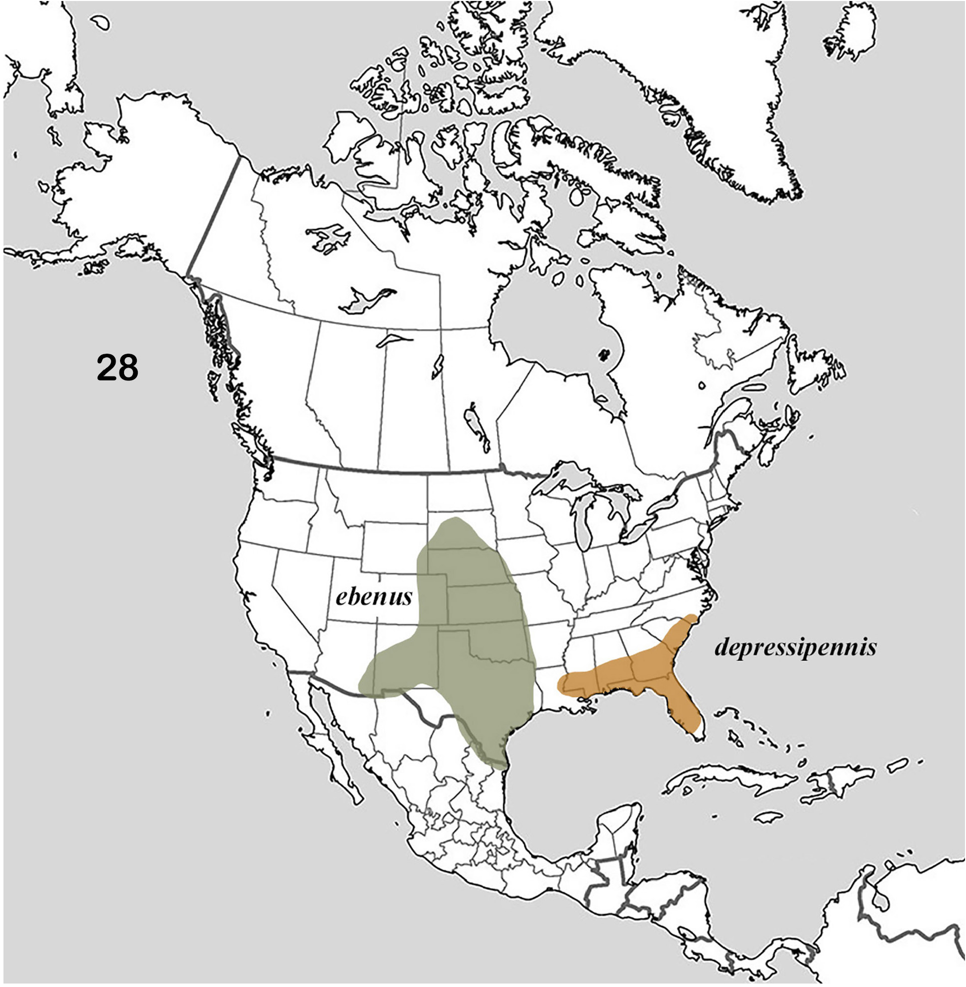
Fig. 11–18 View Figures 11–18 , 28 View Figure 28
Canthon depressipennis LeConte 1859c: 11 View in CoL .
Boreocanthon depressipennis (LeConte) View in CoL (new combination per Halffter 1958: 209).
Canthon (Boreocanthon) depressipennis LeConte View in CoL (new combination per Howden 1966: 727).
Boreocanthon depressipennis LeConte View in CoL , restored generic combination.
Type material. Syntype (sex undetermined),Museum of Comparative Zoology,Cambridge( MCZ-ENT 00003696). Examined by photograph (https://mczbase.mcz.harvard.edu/guid/ MCZ:Ent:3696).
Type locality. Georgia.
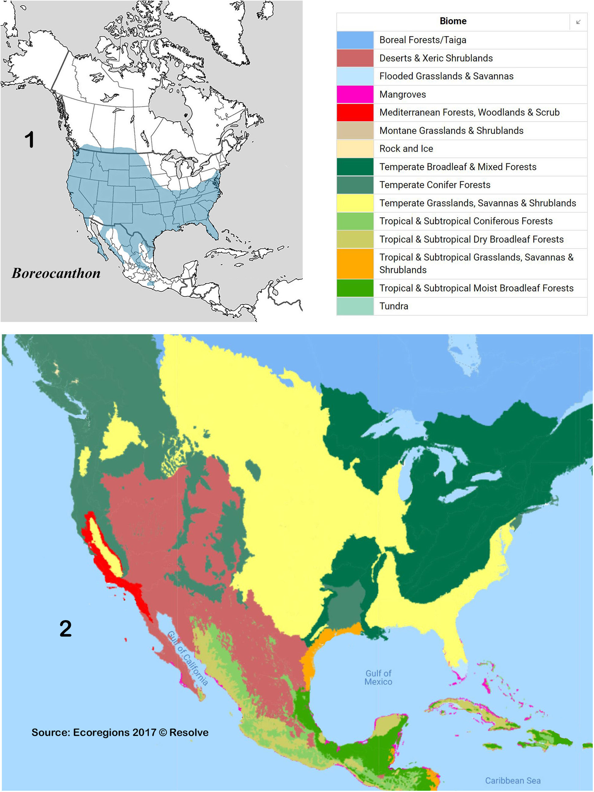
Diagnosis. Head: Anterior portion of clypeus finely roughened, only slightly shinier than rest of head; posterior portion evenly granulate on shagreen background. Sexdentate ( Fig. 11 View Figures 11–18 ); clypeus with four strong teeth, paraocular notch deep, setting off dentate anterior angle of paraocular area. Labio-gular fimbria ( Fig. 15 View Figures 11–18 ) widely V-shaped, strongly narrowed medially, length exceeding one-half that of gula. Prothorax: Evenly, rather densely covered by smaller, rounded granules, granules isolated, only rarely coalescent ( Fig. 11, 13b View Figures 11–18 ). Anterior pronotal angles not upturned; circumnotal ridge serrate posterolaterally, ridge extending beyond posterior angle to point even with elytral umbone ( Fig. 13b View Figures 11–18 , arrows). Hypomeral carina obsolete or only feebly indicated. Pterothorax: Mesoventrite densely, finely punctate medially, smooth laterally. Metaventrite ( Fig. 12 View Figures 11–18 ) with obsolete granules and scattered, minute punctures on shagreen background. Elytra: Interstriae ( Fig. 11 View Figures 11–18 ) evenly, rather densely granulate on shagreen background; 2 nd and 3 rd weakly raised. Striae superficial, edges ill-defined, course determined by lack of granulation (tracks through field of granules). Suhumeral (8 th) stria not carinulate; epipleural (9 th) clearly indicated. Legs: Inner margin of protibia ( Fig. 16 View Figures 11–18 ) clearly offset at level of basal (3 rd) tooth, prolonged apically as conical tooth ( Fig. 16 View Figures 11–18 arrow). Protibial spur ( Fig. 16 View Figures 11–18 ) acute, curved mesally in both sexes. Hind femur lacking row of conspicuous setae along anterior margin. Abdomen: Pygidium ( Fig. 14 View Figures 11–18 ) depressed basally on each side of median swelling; evenly granulate. Sixth ventrite completely granulate; granules on remaining ventrites confined to lateral (upper) areas adjacent to elytral epipleuron. Genital capsule: Compressed, distal portion of parameres elongate, triangular ( Fig.18 View Figures 11–18 ), lower apical angles in form of elongate knobs ( Fig. 17 View Figures 11–18 ). General: Dorsum dark, often appearing black to unaided eye, almost always displaying dull green or yellow-green highlights under magnification. Length: 4.5 – 9.0 mm. Geographic distribution ( Fig. 28 View Figure 28 ): Southeastern United States, from eastern Louisiana to southern North Carolina, southward into the Florida peninsula. Ecogeographic environment ( Fig. 2 View Figures 1–2. 1 ): Temperate Grasslands, Savannas and Shrublands biome (Southeast U.S. conifer savannas ecoregion). Specimens examined: 567.
Collection localities.
UNITED STATES — ALABAMA: Dale Co. ● Fort Rucker Military Reservation [May]. FLORIDA: Alachua Co. ● 0.75 mi W Archer [Jun] ● 4 mi N High Springs [Mar] ● 10 mi SW Gainesville [Aug]; Baker Co. ● Glen St. Mary [Sep]; Calhoun Co. ● Clarksville [Mar]; Citrus Co. ● Inverness [May]; Clay Co. ● Camp Crystal (Mar-Apr]; DeSoto Co. ● 27°19.356 ʹ N 81°48.640 ʹ W, 8 mi N Arcadia; Dixie Co. ● 29°34.6 ʹ N 82°58.3 ʹ W, near Old Town ● 3.7 and 5 mi N Old Town [May]; Duval Co. ● Jacksonville [Apr]; Escambia Co. ● Pensacola; Flagler Co. ● Hwy 1, 2 mi S Hwy I-95 [Oct]; Gilchrist Co. ● 5 mi W Newberry ( Alachua Co. ) [Jun]; Hernando Co. ● Powell [Jul]; Highlands Co. ● Archbold Biological Station [Mar, Jun] ● Dover; Hillsborough Co. ● Tampa, University South Florida campus [May-Jun]; Lafayette Co. ● Picket Lake [Mar]; Lee Co. ● Hwy 41, 3.4 mi NW Koreshan State Park [Apr]; Lake Co. (no data); Levy Co. ● 3.8 mi SW Archer [Mar]; ● 2 mi W Archer [Jun]; ● Route 24, 0.2 mi S Alachua county line [Mar] ● Hwy 241, 1 km N Santa Fe River ● 11 mi W Otter Creek [Nov]; Liberty Co. ● Apalachicola Bluffs & Ravines Preserve, Alum Bluff [Jul]; Madison Co. ● Pinetta [Aug]; Okaloosa Co. ● Valparaiso [Jul]; Orange Co. ● Walt Disney World [Aug]; Putnam Co. ● Red Water Lake [Jul]; Saint Johns ● St. Augustine; Sarasota Co. ● Myakka River State Park, 27°17.541 ʹ N 82°17.420 ʹ W [Sep]; Seminole Co. ● Econ River Wilderness Area [Jul]; Suwanee Co. ● 7 mi N Live Oak [Mar]; Taylor Co. ● County Road 150, 5 mi W Hwy 19 [May]. (See also Woodruff for additional Florida records.) GEORGIA: Baker Co. ● Newton [Jun] ● Ichauway Ecological Reserve [Mar]; Burke Co. ● 10.2 km NW Girard, Yuchi Wildlife Management Area, 33°05 ʹ 36 ʺ N 81°48 ʹ 04 ʺ W [Apr]; Charlton Co. ● Billys Island, Okefenokee Swamp [Oct] ● Camp Cornelia [May]; Chatham Co. ● 12 km NNW Richmond Hill, 32°02 ʹ 41 ʺ N 81°20 ʹ 13 ʺ W [May]; Cook Co. ● Reed Bingham State Park [Jul]; Decatur Co. ● Spring Creek [Jul-Aug]; Dodge Co. ● 1.2 mi NE Gresston [Mar]; Dougherty Co. ● (no data) [Sep]; Emanuel Co. ● Swainsboro [Jul]; Glynn Co. ● Brunswick [Jul]; Jenkins Co. ● Millen [Jul]; Johnson Co. ● 0.5 mi E Kite [Oct]; Lowndes Co. ● Vidalia [Jul-Aug]; McIntosh Co. ● Sapelo Island, Nanny Goat Beach, 31.39065° -81.26533° [May]; Telfair Co. ● McRae (McRae-Helena) [Jul]; Thomas Co. ● Thomasville; Tift Co. ● Tifton [May, Jul]; Toombs Co. ● Vidalia [Aug]; Ware Co. ● Waycross [Sep]; Wheeler Co. ● Bells Ferry Road, along Ocmulgee River [Apr, Sep]. LOUISIANA: West Feliciana Par. ● Feliciana Natural Area, 30°47.7 ʹ N 91°15.2 ʹ W [Sep]. MISSISSIPPI: Jones Co. ● Laurel [Aug]. NORTH CAROLINA: Moore Co., ● Eastwood [Jul]. SOUTH CAROLINA: Aiken Co. ● Aiken Gopher Tortoise Preserve, 10.7 km NE White Pond, 33°30 ʹ 15 ʺ N 81°24 ʹ 22 ʺ W, 259 ft [Apr]; Beaufort Co. ● Beaufort [Apr]; Colleton Co. ● Islandton [Jun]; Florence Co. ● Florence [Sep]; Georgetown Co. ● 10 km E Georgetown [May]; Horry Co. ● Myrtle Beach [Apr, Jul].
Comments. I regard this species as the sister of B. ebenus , the two having arisen from Pleistocene glaciation splitting the founding ancestral population into two enclaves, one on the Florida Peninsula and the other in a south-central refuge, probably in present day Texas. Holocene expansion may have brought the two into closer proximity than suggested by their presumed distributions ( Fig. 28 View Figure 28 ). I have seen two specimens (Louisiana State Arthropod Museum database 0243611 and 0305000) here regarded as B. depressipennis from eastern Louisiana (West Feliciana Parish) very near the Mississippi River. These specimens have the expected weak greenish cast and prolonged pronotal ridge but exhibit the coarser, more coalesced pronotal granulation of B. ebenus . On the other hand, I have also recorded B. ebenus adjacent to the Mississippi River in Bolivar Co. , Mississippi (see Comments for that species). This area, along the southern portion of the Mississippi River, would be a good venue to test the notion that it is a zone of hybridization, whether by secondary contact or nascent divergence.
On the type locality of B. depressipennis Woodruff (1973) stated, “Originally described from Kansas, although Robinson [1948] … erroneously listed the type locality as Georgia.” Woodruff in fact erroneously corrected Robinson as LeConte explicitly states that it is “… a species found in Georgia …” The distribution of B. depressipennis follows the coastal lowlands of the southeastern United States, including the Florida peninsula. Woodruff ’s (1973) distribution map extends it also to the west and northward into a large portion of the Great Plains, which I assume is based upon erroneous records attributable to B. ebenus and B. praticola , which are very common in the region. This species very often presents a dark green color, but it can be black like its close relative, B. ebenus , within a single population.
Fincher et al. (1970) reported that this species was commonly collected on chicken droppings, as well as opossum, rabbit, swine, fox and rat feces, but not those of human, sheep or dog, in Tift County, southern Georgia. Woodruff (1973) found it common in cow dung in open, sandy Florida pastures.
In addition to the syntype cited above, there is another probable syntype also present in the LeConte Collection at the Museum of Comparative Zoology, Harvard University (Crystal Maier, pers. comm).

| MCZ |
Museum of Comparative Zoology |
No known copyright restrictions apply. See Agosti, D., Egloff, W., 2009. Taxonomic information exchange and copyright: the Plazi approach. BMC Research Notes 2009, 2:53 for further explanation.
|
Kingdom |
|
|
Phylum |
|
|
Class |
|
|
Order |
|
|
Family |
|
|
Genus |
Boreocanthon depressipennis (LeConte, 1859)
| Edmonds, W. D. 2022 |
Canthon (Boreocanthon) depressipennis
| Howden HF 1966: 727 |
Boreocanthon depressipennis (LeConte)
| Halffter G. 1958: 209 |
Canthon depressipennis
| LeConte JL 1859: 11 |