
Hycleus herero ( Borchmann, 1940 )
|
publication ID |
https://doi.org/ 10.11646/zootaxa.4373.1.1 |
|
publication LSID |
lsid:zoobank.org:pub:202AFD20-7B37-405A-9CBA-051EF24E9FB2 |
|
DOI |
https://doi.org/10.5281/zenodo.5990611 |
|
persistent identifier |
https://treatment.plazi.org/id/F72687E4-FFDA-FF82-FF5F-FC86FC564F1B |
|
treatment provided by |
Plazi |
|
scientific name |
Hycleus herero ( Borchmann, 1940 ) |
| status |
|
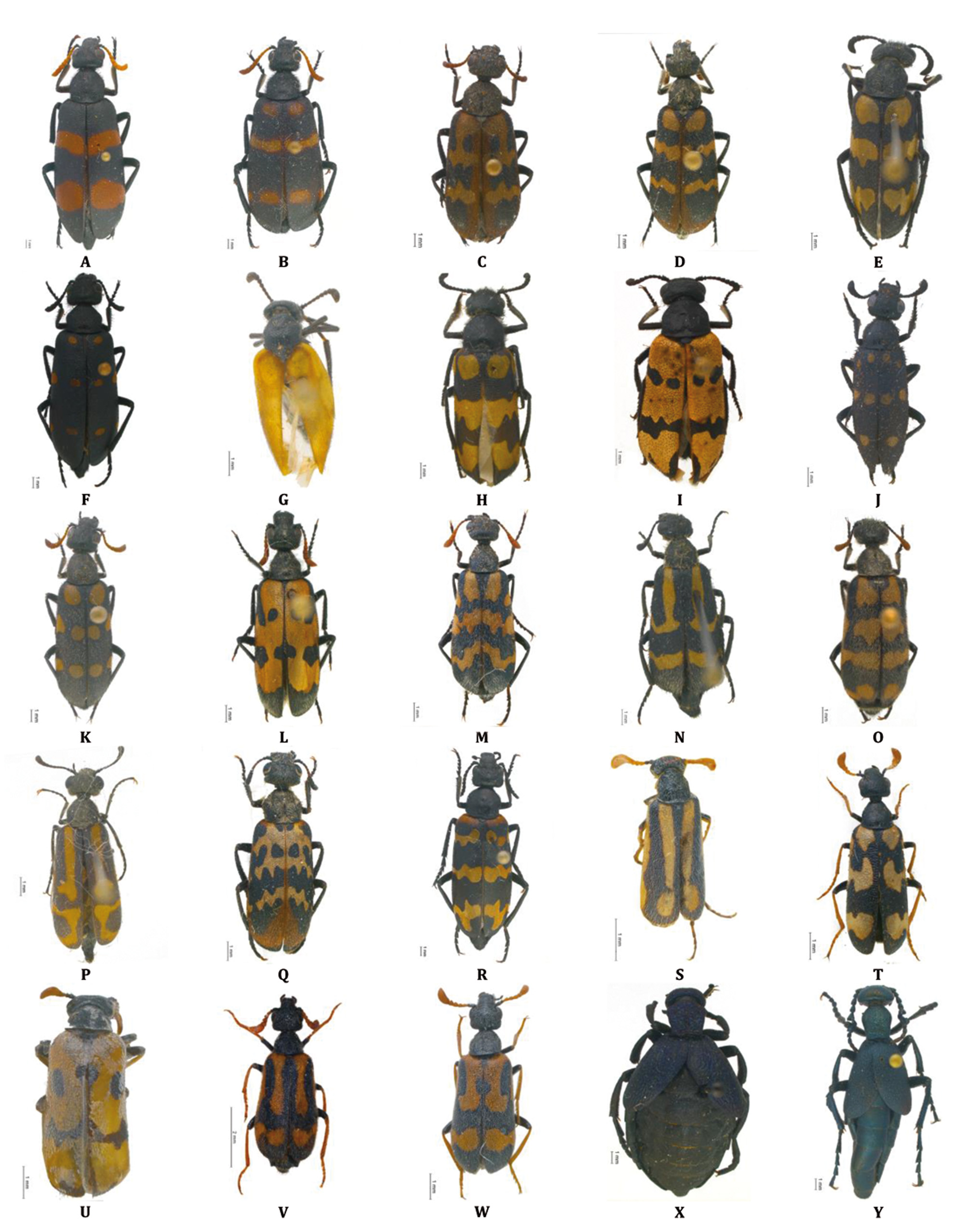
Hycleus herero ( Borchmann, 1940) ( Fig. 5A View FIGURE 5 )
Mylabris herero Borchmann, 1940
Distribution. Namibia (endemic).
Material examined and literature records. [Otjozondjupa] Okahandja: Okahandja Gross Barmen , 22.1000°S 16.7500°E (CB). GoogleMaps
Other records: Hereroland ( Borchmann 1940, type locality); Damaraland ( Kaszab 1956); Namibia ( Bologna 2000a) .
Remarks. Type of this species was not examined and is probably lost.
Bologna (2000a) hypothesized the synonymy of this species with H. hybridus . Actually, after the examination of the male specimen from Okahandja, which strictly agrees with the description, we consider H. herero as a distinct species. It differs from H. hybridus , a species widespread in Namibia , at least by the following characters: (i) fore margin of fore depression of male maxillary stipes squared and posteriorly delimited by a shiny expansion, while in hybridus this depression is oval and rounded in front; (ii) punctures of head, pronotum and elytra very deep and approached; (iii) elytral red and black colouration clean and not vanished as in hybridus .
In Figs. 15 A –D View FIGURE15 are illustrated: male genitalia in lateral view ( Fig. 15 A View FIGURE15 ), mesosternum ( Fig. 15B View FIGURE15 ); male stype ( Fig. 15C View FIGURE15 ) and male maxillary palpi ( Fig. 15D View FIGURE15 ).
Hycleus hybridus ( Marseul, 1872) ( Fig. 5B View FIGURE 5 )
Mylabris (Mylabris) hybrida Marseul, 1872
Distribution. Angola, Botswana, Namibia , and northwestern South Africa.
Material examined and literature records. [Omusati] Ruacana: C46, near Ruacana Falls , 17.4000°S 14.2833°E (CB); 4 km SW Ruacana Falls GoogleMaps , 17.4167°S 14.2167°E (SMWN). Okahao: Kakoveld vegetation, Etosha N.P., 18.9661°S 14.8739°E ( SMWN) GoogleMaps ; Otjovasandu , Etosha N.P., 19.2500°S 14.5000°E ( SMWN) GoogleMaps ; btw. Kaross and Zebrapump, 19.3667°S 14.5000°E (SMWN). [Kunene] Epupa: Okokatuwo , 17.4500°S 12.7000°E ( SMWN) GoogleMaps . Opuwo: 21 km E of Orupembe , 18.1785°S 12.4136°E ( SMWN) GoogleMaps ; Kaokoveld, Anabib (Orupembe), 100 miles W Ohopoho, 18.1833°S 12.5167°E ( Kaszab 1956); D3710, near Opuwo ,, 18.2011°S 13.8994°E (CB) GoogleMaps ; 8 km E of Orumana , 18.2333°S 13.8833°E ( SMWN) GoogleMaps ; 25 km S Opuwo , 18.2830°S 13.7923°E ( SMWN) GoogleMaps ; Otjitundua , 18.6500°S 14.2333°E ( SMWN) GoogleMaps ; Kunene distr., C43, 18.6788°S 13.7135°E (CB) GoogleMaps ; Kunene distr., C43, 18.7599°S 13.7489°E (CB) GoogleMaps ; 42 km NW of Giribes Vlakte , 18.8180°S 13.1130°E ( SMWN); Kunene distr. GoogleMaps , C43, 18.9562°S 13.7573°E (CB). Sesfontein: Khowarib River GoogleMaps , 19.2667°S 13.8667°E (SMWN); Khowarib River, crossing 6 km N, 19.2667°S 13.8667°E ( SMWN) GoogleMaps ; D2650, near Kamanjab, 19.8087°S 14.5128°E (CB); Palmwag 702, 19.8333°S 13.8833°E ( SMWN) GoogleMaps ; Humor 704, 19.8439°S 14.1231°E ( SMWN) GoogleMaps ; Palm 708, 19.9000°S 13.9833°E ( SMWN) GoogleMaps . Kamanjab: Kamanjab , 19.6333°S 14.8333°E ( SMWN) GoogleMaps ; C40, 26 km E Kamanjab, 19.6957°S 15.1046°E (CB); Otjitambi 25, 19.8167°S 15.1667°E ( SMWN) GoogleMaps ; C39, 23 km W Outjo, 20.1798°S 15.9480°E (CB); C39, 25 km E Khorixas, 20.3061°S 15.1867°E (CB). Outjo: Ike 346, 19.7533°S 16.6244°E ( SMWN) GoogleMaps . Khorixas: Khorixas , 20.3500°S 14.9500°E ( SMWN) GoogleMaps ; Khorixas , 20.3667°S 14.9667°E ( SMWN) GoogleMaps ; Bethanis 514, 20.4000°S 14.4000°E ( SMWN) GoogleMaps ; Krone 721, 20.5373°S 13.9799°E ( SMWN) GoogleMaps ; Huab River Valley, 20.6167°S 13.9000°E ( SMWN) GoogleMaps ; Sebraskop 410, 20.7333°S 15.1500°E ( SMWN) GoogleMaps ; Duineveld 529, 20.7833°S 14.6333°E ( SMWN) GoogleMaps . [Oshikoto] Omuthiyagwiipundi: 30 km E Etosha N.P. Mokuti Lodge, 18.8000°S 17.0333°E (CB); Halali, toilet Camp , Etosha N.P., 18.9500°S 16.5500°E ( SMWN) GoogleMaps ; Etosha N.P., Halali Rest Camp, 19.0333°S 16.4667°E (CB); Etosha N.P., Halali, 19.0500°S 16.4667°E (CB); Etosha N.P. near Okaukejo , 19.1833°S 15.9333°E (CB); Gobaub, Etosha N.P., 19.3000°S 16.4167°E ( SMWN) GoogleMaps . Guinas: Otjikoto Lake, Tsumeb , 19.1833°S 17.5500°E ( SMWN) GoogleMaps . [Otjozondjupa] Grootfontein: Hurisib 533, 19.3833°S 17.9167°E ( SMWN) GoogleMaps . Otavi: Dakota 424, 19.4833°S 17.1333°E ( SMWN) GoogleMaps ; Kudib 426, 19.4833°S 17.2500°E ( SMWN) GoogleMaps ; Dakota 424, 19.4941°S 17.1287°E ( SMWN) GoogleMaps ; Kudib 426, 19.5118°S 17.2475°E ( SMWN) GoogleMaps ; B8, 10 km E Otavi, 19.6500°S 17.4167°E (CB). Otjiwarongo: D2430, 25 km N Otjiwarongo, 20.2667°S 16.6167°E (CB); Otjiwa , 18.7621°S 13.7333°E ( SMWN) GoogleMaps . Omatako : Onjoka, Waterberg Plateau Park, 20.4167°S 17.2500°E ( SMWN) GoogleMaps ; Mount Etjo Safari Lodge , 21.0167°S 16.4167°E (CB); Kalkfeld: Omukandi ( MCZR) GoogleMaps . Okahandja: Okahandja , 21.9833°S 16.9167°E ( SMWN) GoogleMaps . [Erongo] Dâures: Ugab River near Onverwag , 20.8620°S 14.9890°E ( SMWN) GoogleMaps ; Otjohorongoro Mt., 20.8817°S 15.5168°E (CB); Brandberg , 21.1333°S 14.5833°E ( Bologna 2000a; SMWN) GoogleMaps ; Okonyenye Mt., Otjihorongo Reserve , 21.1500°S 15.3167°E ( SMWN) GoogleMaps ; Gross Spitzkoppe, 21.8167°S 15.1667°E (CB). Omaruru: Otjongoro 20, 20.8833°S 15.6333°E ( SMWN) GoogleMaps ; Otjikoko S 61, 21.2833°S 16.3667°E ( SMWN) GoogleMaps ; C33, 6 km S Omaruru, 21.4824°S 15.9508°E (CB). Karibib: D1935, 30 km NNW Usakos, 21.7833°S 15.5000°E (CB); Karibib , 21.9333°S 15.8333°E (CB); Navachab 67, 22.0167°S 15.7333°E ( SMWN) GoogleMaps ; D1980, 27 km S Karibib , 22.1500°S 15.8333°E (CB); C32, 54 km S Karibib, Swakop River GoogleMaps , 22.3954°S 15.8343°E (CB); 20 km W Boshua Pass, 22.6640°S 15.8780°E (CB); C28, Boshua Pass, 22.7000°S 16.0333°E (CB). Arandis: Upper Panner Gorge GoogleMaps , 22.4833°S 15.0167°E (SMWN); Ganab, Walvisbaai, 23.0667°S 15.1667°E (SMWN); C14, Kuiseb River, 23.3046°S 15.7718°E (CB) GoogleMaps . Walvis Bay Rural: Kuiseb Canyon , 23.3667°S 15.6667°E ( SMWN) GoogleMaps ; Rostock, Windhoek, 23.3833°S 15.7500°E (SMWN); Gorob Mine, Namib Desert Park, 23.5333°S 15.4167°E (SMWN). [Omaheke] Steinhausen: Swakop River, Okahandja , 22.0500°S 18.9000°E ( SMWN) GoogleMaps . [Khomas] Windhoek Rural: Otjiseva 45, 22.3000°S 16.9667°E ( SMWN) GoogleMaps ; Whindoek , 22.5750°S 17.0831°E ( RMCA) GoogleMaps ; Brakwater, 20 km N Windhoek, 22.4000°S 17.0667°E (CB); Daan Viljoen Game Park , 22.5333°S 16.9333°E (CB); Daan Park , 22.5333°S 16.9667°E (CP); Windhoek Airport , 22.5333°S 17.2500°E (CB); Regenstein 32, 22.7178°S 17.0317°E ( SMWN) GoogleMaps ; Lichtenstein , 22.7667°S 16.9833°E ( SMWN) GoogleMaps ; Wasservalley 382, 22.9167°S 16.3667°E ( SMWN) GoogleMaps ; C23, 38 km S Dordabis , 23.0715°S 18.0434°E (CB) GoogleMaps ; 8 km E of Namib Park Border, 23.3167°S 15.8667°E ( SMWN) GoogleMaps ; C14, 10 km N Solitaire, 23.7188°S 15.8776°E (CB). Windhoek East: Windhoek , 22.5667°S 17.0833°E ( SMWN) GoogleMaps ; Windhoek, 22.5700°S 17.0836°E (CB); Avis Dam , 22.5728°S 17.1314°E ( SMWN) GoogleMaps . [Hardap] Rehoboth West Urban: near Rehobot, 23.3167°S 17.0833°E (CP). Gibeon : Sukses 133, 24.3000°S 15.8833°E ( SMWN) GoogleMaps ; C14, 1 km W Maltahöhe , 24.8589°S 16.9751°E (CB). GoogleMaps
Other records: Swakop ( Pardo Alcaide 1958a); Swakop River (CB); Kaokoveld Cropembe ( Pardo Alcaide 1958a); Damaraland ( Péringuey 1909); Rooilyn (SMWN); Tuyeb (SMWN); Namib Sand Sea desert ( Seely 2012); Namibia ( Bologna 2000a; Pitzalis et al. 2014).
Remarks. Types of this species were examined at MNHN.
See above for the distinction from H. herero ( Borchmann, 1940) .

No known copyright restrictions apply. See Agosti, D., Egloff, W., 2009. Taxonomic information exchange and copyright: the Plazi approach. BMC Research Notes 2009, 2:53 for further explanation.
|
Kingdom |
|
|
Phylum |
|
|
Class |
|
|
Order |
|
|
Family |
|
|
Genus |
Hycleus herero ( Borchmann, 1940 )
| Bologna, Marco A., Amore, Valentina & Pitzalis, Monica 2018 |
Mylabris herero
| Borchmann 1940 |
Mylabris (Mylabris) hybrida
| Marseul 1872 |