
Libitia bipunctata Sørensen, 1932
|
publication ID |
https://doi.org/ 10.5852/ejt.2020.634 |
|
publication LSID |
lsid:zoobank.org:pub:66AEE1D7-51BF-4583-9A19-947F61ECC7DE |
|
DOI |
https://doi.org/10.5281/zenodo.3795372 |
|
persistent identifier |
https://treatment.plazi.org/id/03AC87DB-EC57-CA12-7D2D-5363FBB249C8 |
|
treatment provided by |
Valdenar |
|
scientific name |
Libitia bipunctata Sørensen, 1932 |
| status |
comb. rev |
Libitia bipunctata Sørensen, 1932 View in CoL comb. rev.
Figs 1–4 View Fig View Fig View Fig View Fig , 14 View Fig
Libitia (Libitia) bipunctata Sørensen in Henriksen, 1932: 417 View in CoL .
Libitia bipunctata View in CoL – Mello-Leitão 1933: 109.
Libitiella bipunctata View in CoL – Roewer 1947: 8, pl. 1, fig. 3.
Diagnosis
Can be distinguished from L. cordata and L. gandalf sp. nov. by having small white-yellowish blots restricted to the marginal scutal groves (or sulci) (rails, see Medrano & Kury 2016) as dissociated
pattern; from L. iguaque sp. nov. by having coda as long as mid-bulge and by possessing penis with MS D1 closer to MS C2 than MS D2.
Etymology
The name is derived from the Latin ‘ bipunctatus ’, meaning ‘one who has two blots’.
Material examined
Syntypes
COLOMBIA • 2 ♀♀; Cundinamarca Department [originally mistakenly reported as “Venezuela”], without further locality data; BMNH • 3 ♂♂, 2 ♀♀; between La Unión and Páramo de Chingaza [originally misspelled as “Chingusa”]; 1000–2400 m a.s.l.; ZMG .
Other material
COLOMBIA – Cundinamarca Department • 26 ♂♂, 17 ♀♀, 20 juvs; Bogotá, Cantera Soratama ; 2800 m a.s.l.; A. Álvarez leg.; MPUJ_ENT 11432 • 1 ♂, 1 ♀; Bogotá, Humedal La Conejera; 4.760671° N, 74.106359° W; 2600 m a.s.l.; Apr. 2000; ICN-AO 292 GoogleMaps • 1 ♂; Bogotá, Quebrada La Vieja ; 4.649889° N, 74.048065° W; 2600 m a.s.l.; 12 Dec. 2010; O. Villarreal, D. Luna and M. Medrano leg.; ICN-AO 922 GoogleMaps • 4 ♂♂, 16 ♀♀; Bogotá, Sierras del Chicó , 4.671375° N, 74.038878° W; 15 May 2007; I. Morales leg.; ICN-AO 470 GoogleMaps • 10 ♀♀; Bogotá, Usme, Parque Entrenubes, Cerro Juan Rey ; 4.521586° N, 74.097581° W; 2700 m a.s.l.; 23–25 May 2003; L. Benavides leg.; ICN-AO 420 GoogleMaps • 1 ♂, 14 ♀♀; same collection data as for preceding; ICN-AO 419 GoogleMaps • 1 ♂; Choachí, Páramo Cruz Verde vía Bogotá-Choachí ; 4.592793° N, 74.033624°W; 3300 m a.s.l.; 14 Dec. 1979; ICN-AO 76 GoogleMaps • 1 ♂, 1 ♀; Guasca, Reserva Biológica El Encenillo ; 4.794559° N, 73.909036° W; 8–10 Dec. 2012; A. Herrera, C. Suárez and E. Ariza leg.; ICN-AO 1383 GoogleMaps • 1 ♂, 3 ♀♀; Guasca, Reserva Biológica El Encenillo ; 8–10 Dec. 2012; C. Suárez and E. Ariza leg.; necrotrampa; ICN-AO 1204 • 12 ♀♀; La Calera, E.A.A.B. Club La Aguadora - Embalse de San Rafael ; 4.706040° N, 74.008119° W; 2700 m a.s.l.; Sep. 2010; P. Barriga and D. Tobar leg.; ICN-AO 472 GoogleMaps • 5 ♀♀; same collection data as for preceding; ICN-AO 484 GoogleMaps • 1 ♂; Parque Nacional Natural Chingaza, Alto de La Bandera ; 4.719018° N, 73.820675° W; 3660 m a.s.l.; IAvH-I-64 GoogleMaps • 1 ♂; same collection data as for preceding; IAvH-I-67 GoogleMaps • 1 ♀; same collection data as for preceding; IAvH-I-76 GoogleMaps • 1 ♀; same collection data as for preceding; IAvH-I-77 GoogleMaps • 1 ♂; Parque Nacional Natural Chingaza, La Siberia; 4.712840° N, 73.945862° W; 3170 m a.s.l.; IAvH-I-72 GoogleMaps • 1 ♀; same collection data as for preceding ; IAvH-I-73 GoogleMaps • 1 ♂; Parque Nacional Natural Chingaza , Vda. El Manzano, Reserva Forestal Río Blanco , Palacio Laguna Brava ; 4.675665° N, 73.880396° W; 2930 m a.s.l.; IAvH-I-87 GoogleMaps • 1 ♀; Parque Nacional Natural Chingaza, Valle del Fraylejón ; 4.525783° N, 73.774845° W; 3170 m a.s.l.; IAvH-I-122 GoogleMaps • 4 ♂♂, 2 ♀♀; Parque Nacional Natural Chingaza ; 4.575° N, 73.853° W; 2950 m a.s.l.; Y. Cifuentes leg.; ICN-AO 1437 GoogleMaps • 1 ♀; San Antonio del Tequendama, Los Tunos ; 4.564730° N, 74.218390° W; 2009; ICN-AO 996 GoogleMaps • 1 ♂; Sibate, Alto de San Miguel ; 4.450395° N, 74.300759° W; 2630 m a.s.l.; 1 Dec. 1979; I. de Arevaldo leg.; ICN-AO 78 GoogleMaps • 1 ♂, 1 ♀; Soacha, near Chusacá ; 4.538153° N, 74.280819° W; 2770 m a.s.l.; Dec. 1979; ICN-AO 52 GoogleMaps • 1 ♂; Zipaquirá, Vereda Ventalarga, Represa Pantano Redondo ; 5.042453° N, 74.036160° W; 3000 m a.s.l.; 27 Apr. 2013; E. Florez et al. leg.; ICN-AO 468 GoogleMaps .
Redescription
Male (ICN 419)
MEASUREMENTS. CL = 1.4, AL = 2.7, CW = 2.4, AW = 3.3, IOD = 0.6, Fe I = 1.7, Ti I = 1.3, Fe II = 2.9, Ti II = 2, Fe III = 2.5, Ti III = 1.5, Fe IV = 2.7, Ti IV = 2.1.
DORSUM ( Fig. 1 View Fig A–D). Dorsal scutum alpha-type, finely granular. Free tergites with rows of granules. Posterior margin of dorsal scutum convex. Small white-yellowish blots restricted to the marginal scutal groves, not invading the areas of mesotergum nor grooves medially.
VENTER. Free sternites finely granular; coxae II–IV finely and uniformly granular; coxa I with longitudinal row of tubercles and smooth area corresponding to lace area of pedipalp. Anal operculum finely granular
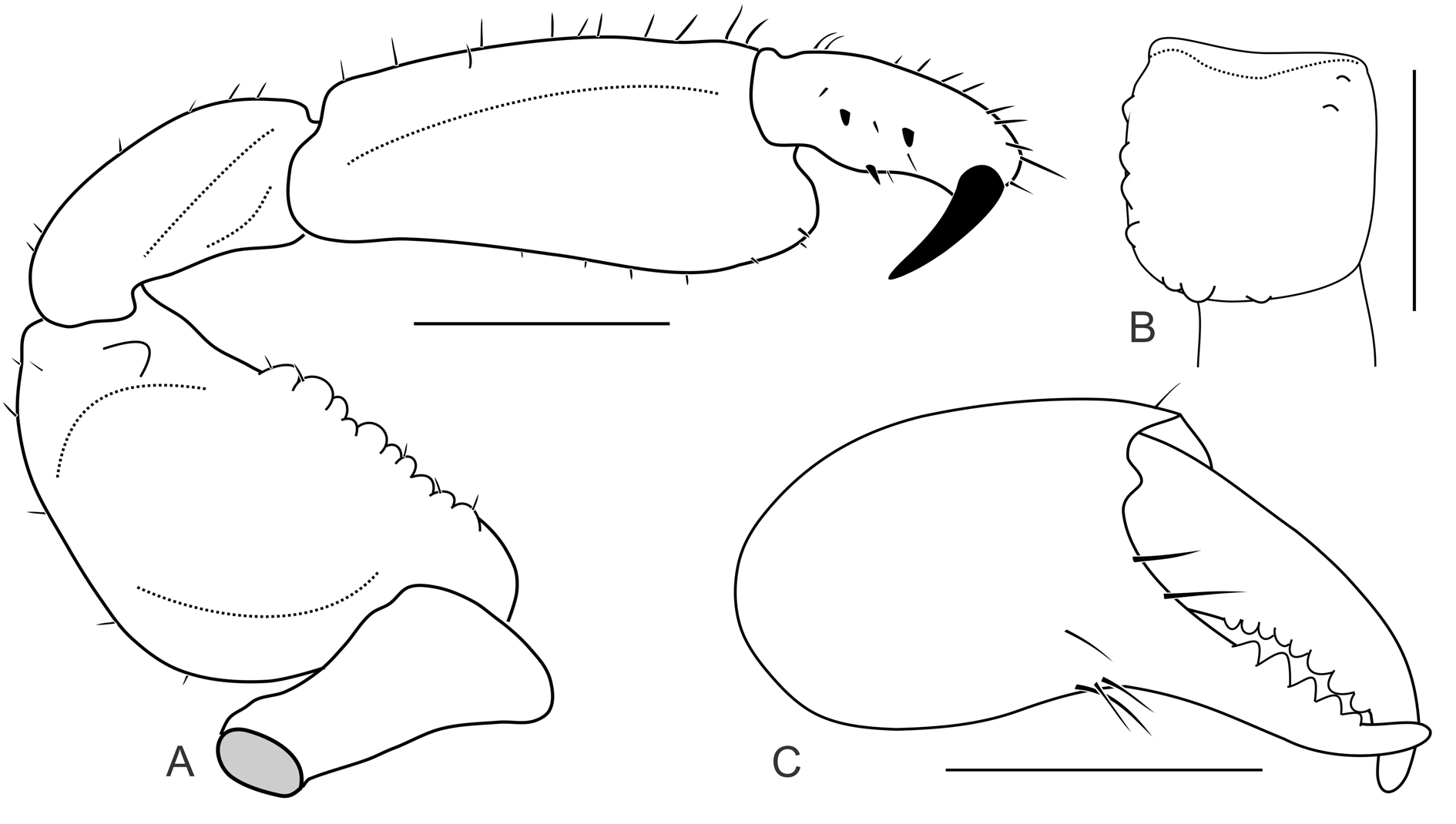
CHELICERAE ( Fig. 3 View Fig B–C). Basichelicerite finely and uniformly granular with some rounded protuberances in basal and ectal margins, two ectodistal small setiferous protuberances. Movable finger with row of eight teeth; fixed finger with five triangular teeth, decreasing in size from distal to basal part of finger.
PEDIPALPS ( Fig. 3A View Fig ). Trochanter with strong ventral apophysis. Femur dorsally convex without pronounced dorsal keel or tubercles, with ventral row of ten well-formed setiferous tubercles and a mesodistal process. Patella with mesal keel. Shallow slit along tibia mesal surface, separating dorsal and ventral sides.
LEGS ( Fig. 1B View Fig , E–F). Uniformly granular, femora III and IV slighted curved backwards. Coxae I-IV with prolateral conical apophyses, I and II larger than III and IV. Tarsal claws of legs III and IV smooth. Tarsal counts: 5(3)/6(3)/5/5.
COLOR ( Fig. 1 View Fig ). Body and appendages background Strong Orange Yellow (68) mottled in Dark Yellowish Brown (78), ladder mask Pale Greenish Yellow (104). Pedipalpus as well as trochanters and tarsomeres of legs Light Greenish Yellow (101).
Female
Dorsal scutum and Fe IV shorter than males, with coda wider. Basitarsomeres I, III and IV not enlarged.
Variation ( Fig. 2 View Fig )
Pattern of yellow spots varying from an immaculate dorsal scutum to a well-filled ladder mask.
Habitat
Some specimens (material examined) were collected in leaf litter and under rocks from High-Andean forest to Paramo, between 2600–3660 m, using both manual collect and passive methods, as a pitfall or ‘necrotrampa’ used for animals with affinity for decomposed organic matter.


| BMNH |
United Kingdom, London, The Natural History Museum [formerly British Museum (Natural History)] |
| ZMG |
Zoologischen Museums Greifswald |
No known copyright restrictions apply. See Agosti, D., Egloff, W., 2009. Taxonomic information exchange and copyright: the Plazi approach. BMC Research Notes 2009, 2:53 for further explanation.
|
Kingdom |
|
|
Phylum |
|
|
Class |
|
|
Order |
|
|
Family |
|
|
Genus |
Libitia bipunctata Sørensen, 1932
| Medrano, Miguel, Ázara, Ludson Neves de & Kury, Adriano Brilhante 2020 |
Libitiella bipunctata
| Roewer C. F. 1947: 8 |
Libitia bipunctata
| Mello-Leitao C. F. de 1933: 109 |