
Miconia spiciformis Gamba & Almeda, 2014
|
publication ID |
https://doi.org/ 10.11646/phytotaxa.179.1.1 |
|
DOI |
https://doi.org/10.5281/zenodo.5156379 |
|
persistent identifier |
https://treatment.plazi.org/id/03C887CB-FBD1-FF05-FACB-EA35FCBE5A65 |
|
treatment provided by |
Felipe |
|
scientific name |
Miconia spiciformis Gamba & Almeda |
| status |
nom. nov. |
31. Miconia spiciformis Gamba & Almeda View in CoL , nom. nov. Basionym: Ossaea spicata Gleason (1941: 253) . Type: COLOMBIA. Intendencia El Chocó: dense forest south of Río Condoto, between Quebrada Guarapo and Mandinga, 120–180 m, 22–28 April 1939, Killip 35166 (holotype: NY!; isotypes: BM-internet image!, COL-2 sheets-internet images!, US-internet image!). Nec Miconia spicata Macfadyen ex Grisebach (1860b: 257 ; M. triplinervis Ruiz & Pavón (1798: 105)) .
Shrub or tree 2–8.5 m tall with more or less lax branching, bark green-brown. Upper internodes terete to roundedquadrate, (1.5–) 2.5–4.9 cm long, cauline nodes terete with a prominent nodal ridge that is confluent with the abaxial bases of the petioles but frequently obscured by the dense tomentum. Indumentum on branchlets, petioles, primary veins abaxially, inflorescence axes, bracts, bracteoles, hypanthia, calyx lobes abaxially, and exterior calyx teeth densely covered with white subulate-matted elongate smooth trichomes 1–1.2 mm long, intermixed with or occasionally replaced by a dense to moderate whitish understory of dendritic trichomes 0.2–0.3 mm long with short to moderately long thin-walled (flattened) arms. Leaves of each pair isophyllous; the petioles 0.3–0.8 cm long, erect and nearly parallel to the subtending internode, the adaxial canaliculate surface densely and caducously tomentose; blades 14–22.5(–28.4) × 4–6.5(–8.5) cm, oblong-elliptic to oblanceolate, the base acute, the margin repand-denticulate to subentire, the apex acuminate, chartaceous; mature leaves adaxially with actual surface, primary, secondary, tertiary and higher order veins glabrous; abaxial surface glabrous, the secondary and tertiary veins moderately covered with the same dendritic trichomes of the general indumentum; 5-nerved, including the tenuous marginals, areolae 0.4–0.5 mm, adaxially the primary and secondary veins impressed, the tertiary and higher order veins flat, abaxially the primary and secondary veins elevated and terete, the tertiary and higher order veins slightly raised. Inflorescences a pendant unbranched pseudolateral interrupted subverticillate spike 9–14.5 cm long, each verticil appearing fasciculate-glomerulate, including a compressed-rounded to rounded-quadrate peduncle 0.7–1 cm long, solitary or with multiple spikes arising from the upper leaf axils, the rachis green; bracts 6–8 × 3–5 mm, triangular and somewhat concave, green-brown, early deciduous at anthesis; bracteoles 2–4 × 0.6–0.8 mm, ovate-oblong to triangular, green-brown, early to tardily deciduous at anthesis. Flowers 5-merous, sessile. Hypanthia at anthesis 2–2.5 × 1.5–2(–2.3) mm, free portion of hypanthium 1–1.3 mm long, globose, bluntly 10-ribbed, green turning brown, ridged on the inner surface, glabrous, the torus adaxially sparsely glandular, the glands rounded and sessile. Calyx open in bud and persistent in fruit, green becoming orange; tube 0.3–0.5 mm long, with the same vestiture as the torus adaxially and as the hypanthium abaxially; lobes 0.5–1 × 1 mm, depressed-rounded, the margin vaguely undulate, the apex obtuse; exterior teeth calyx 0.25 mm long, bluntly triangular, inconspicuous, inserted at the base of the calyx lobes and not projecting beyond them. Petals 3–4 × 1–1.5 mm, lanceolate, the margin entire, the apex bluntly acute, white, adaxially moderately papillose, abaxially covered with a copious indumentum of dendritic trichomes 0.3–0.4 mm long with short to moderately elongate thin-walled (flattened) arms, spreading to reflexed at anthesis. Stamens 10; filaments 2–2.25 × 0.25 mm, yellowishbrown, glabrous; anther thecae 1.5–1.75 × 0.4–0.5 mm, oblong-clavate, emarginate at the apex, opening by one dorsally inclined pore 0.1 mm in diameter, white to pale yellow; connective yellowish-brown, its prolongation and appendage 0.6–0.75 mm long, the appendage oblong, bluntly acute to obtuse at the apex, white, copiously glandedged, the glands rounded and stalked, the connective also somewhat prolonged and gland-edged but unappendaged ventro-basally. Ovary 5-locular, 3/4 to completely inferior, 1.3–1.6 mm long at anthesis, the apical
130 Phytotaxa 179 (1) © 2014 Magnolia Press
GAMBA & ALMEDA
collar absent, the apex 0.35 mm in diameter, slightly depressed to conic, sparsely glandular-puberulent; style 5.5–7 mm long at anthesis, moderately narrowed distally (i.e. tapering), white, glabrous; stigma truncate to expanded truncate. Berries 3–4 × 3–4 mm when dry, globose, green to white, turning reddish when ripe, the hypanthial indumentum persistent at maturity. Seeds 0.33–0.43 × 0.15–0.24 mm, typically ovoid, angled, occasionally pyramidal, brownish; lateral and antiraphal symmetrical planes rather ovate, sometimes the lateral one slightly triangular, the highest point toward the chalazal side; raphal zone suboblong, comprising ca. 90% the length of the seed; appendage absent but a small protuberance may be present; individual cells elongate, anticlinal boundaries channeled, undulate, with Ω- and U-type patterns; periclinal walls convex, low-domed to nearly flat, microrelief verrucose or smooth. Chromosome number: n=17.
Additional specimens studied:— COLOMBIA. Chocó: Carretera (en construcción) Yuto-Lloró , 1 km de Yuto , 70 m, 9 September 1976, Forero & Jaramillo 2708 ( COL, MO, US) ; Serranía de Baudó, Alongroad between Las Animas and Río Pato, along valley of Río Animas , 5 km from beginning of road, 5°16’N, 76°41’W, 100 m, 17 April 1983, Croat 56032 ( MO, US); (Nuquí) GoogleMaps , Arusí, Estación Biológica El Amargal, 80 m, February 1992, Pardo et al. 143 ( COL, F); (Quibdó) , Río Cabi , 20 April 1982, Prance 28008A ( NY) ; Río Mecana ca. 10 km Eof Mecana, 6.15°N, 77.25°W, 100 m, 7 March 1983, Gentry & Juncosa 41088 ( MO) GoogleMaps ; Rain forest on hill Nof Altos Curiche, 300 m, 19 May 1967, Duke & Idrobo 11226 ( US-3 sheets) . Valle: (Bahía Málaga) Quebrada Alegría , trail from creek along proposed route of new road to Military Base , 04°02'N, 077°22'W, 50 m, 15 December 1985, Gentry et al. 53339 ( MO, US); ( Buenaventura ) GoogleMaps , Bajo Calima, along road between Buenaventura and Malaga, on carretera Hanz (lumber extraction road Nof main Buenaventura-Malaga Road ), 6.5 km Nof main road, 4°3’N, 77°3’W, 40 m, 2 March 1990, Croat 71106 ( MO, US) GoogleMaps ; La Trojita, Río Calima (región del Chocó ), 5–50 m, 19 February 1944, Cuatrecasas 16297 (F) ; Costa del Pacífico, Río Yurumanguí , entre Isla de Golondro y La Amargura, 10–40 m, 7 February 1944, Cuatrecasas 16027 (F) . NICARAGUA. Río San Juan: (San Juan del Norte ), R. Indio-Maíz, Cerro El Gigante, 5 km del Río San Juan, 10°46’N, 83°53’W, 100–200 m, 21 September 1998, Rueda et al. 8896 ( CAS) GoogleMaps . Zelaya: (Nueva Guinea), R. Indio-Maíz , Río Pijibaye entre el caño Bijagua y el Cerro Chiripa , 11°22’N, 84°1’W, 50–200 m, 13 January 1999, Rueda et al. 10050 ( CAS) GoogleMaps . PANAMA. Bocas del Toro: 8.5 road-miles from bridge near Fortuna Dam on road towards Chiriquí Grande (4.3 miles Nof continental divide), 8°50’N, 82°15’W, 600 m, 10 March 1985, McPherson 6757 ( CAS) GoogleMaps . Coclé: 27 km Nof Penome on road to Coclesito in forest R, at continental divide, 457 m, 20 February 1978, Hammel 1637 ( CAS); (La Mesa) , Above El Vallede Antón , 13 April 1971, Croat 14401 ( NY) ; Along road and in woods about 6 mi Nof El Valle de Antón, 1 August 1970, Luteyn & Kennedy 1605 ( US) ; Alto Calvario above El Copé, ca 6 km Nof El Copé, Atlantic slope, along trail through forest W off old lumber trail which leads down to Las Ricas , Limón and San Juan , 9°39’N, 80°36’W, 23 June 1988, Croat 68784 ( CAS, US) GoogleMaps ; Area between Caño Blanco del Norte, Caño Sucio and Chorro del Río Tife , 8.42–8.43°19–06’N, 80.36–80.38°30’W, 200–400 m, 3 February 1983, Davidse & Hamilton 23528 ( CAS); (Alto Calvario) , along summit of continental divide 5.5 mi Nof El Copé, 3.5 mi Nof Escuela Barrigón , 8°39’N, 80°36’W, 850 m, 13 September 1987, Croat 67559 ( CAS); (Alto Calvario) GoogleMaps , Lumber camp at Alto Calvario, 7 km N of El Copé, 900 m, 14 January 1977, Folsom 1307 ( CAS); ( El Copé ) , División continental arriba de Barrigón y el aserradero viejo, Camino de caballo a Coclesito , 8°40’N, 80°36’W, 880 m, 27 April 1992, Peña et al. 395 ( CAS, PMA) GoogleMaps ; Trail from Río Blanco del Norte to Caño Sucio , 8°44’N, 81°40’W, 350–400 m, 21 February 1982, Knapp 3735 ( CAS) GoogleMaps ; Forested slopes above El Copé along abandoned road leading to the Continental Divide , 700–850 m, 25 February 1988, Almeda et al. 5937 ( CAS, PMA) . Colón: Wmost part of province, site of proposed copper mine ( INMET), Nend of Trailings Area , 8°53’42"N, 80°40’9"W, 100 m, 8 April 2009, McPherson & Serein 20759 ( CAS) GoogleMaps ; Teck Cominco Petaquilla mining concession, Forested slopes below ridgetop road, 8°49’28"N, 80°39’29"W, 180 m, 19 September 2007, McPherson 19717 ( CAS) GoogleMaps . Comarca de San Blas: (Nusagandi), Along continental divide on the El Llano-Carti road, 9°19’N, 78°15’W, 350 m, 30 July 1984, de Nevers & Pérez 3576 ( CAS) GoogleMaps ; El Llano-Carti road, km 22, 9°19’N, 78°55’W, 350 m, 17 June 1986, de Nevers & Herrera 7852 ( CAS) GoogleMaps ; Headwaters of Río Nergala along continental divide, 350 m, 11 January 1985, de Nevers & Herrera 4518 ( CAS) ; El Llano-Carti road, km 18.3, 9°19’N, 78°55’W, 350 m, 1 April 1985, de Nevers et al. 5212 ( CAS) GoogleMaps ; PEMASKY Nature Park, Entrada de Nergan Igar, Km 15 de la carretera Llano-Carti. , 9°20’N, 78°58’W, 350 m, 2 July 1994, Galdames et al. 1239 ( CAS) GoogleMaps . Panamá: P.N. Chagres, Cerro Jefe region, 0.8 mi beyond turn-off to Altos de Pacora (near branch in road to antennas to Cerro Jefe ), 9°15’N, 79°29’W, 770 m, 4 July 1994, Croat & Zhu 76641 ( CAS) GoogleMaps ; P.N. Chagres, Cerro Jefe, Trail leading into forest from these coordinates, off the road to Altos de Pacora , 9°13.41’N, 79°22.26’W, 900 m, 25 January 2005, Penneys & Blanco 1681 ( CAS, US) GoogleMaps ; Campo 3, 5 km NE of Altos
SYSTEMATICS OF THE OCTOPLEURA CLADE OF MICONIA
Phytotaxa 179 (1) © 2014 Magnolia Press 131 de Pacora, 700 m, 9 March 1973, Busey 840 ( NY, US); P.N. Chagres, Cerro Jefe. , 10–13 miles beyond Goofy Lake , 12 February 1966, Duke 8004 ( US); Along newly cut road from El Llano to Carti-Tupile , 12 mi above Pan-Am Highway , 200–500 m, 13 March 1973, Liesner 674 (F, NY, US); Vicinity of Altos Pacora , 15–20 km WNW of Cerro Azul, 800 m, 30 June 1975, Mori et al. 6916 ( US); Road past Altos de Pacora , 3–3.5 mi NE of Altos de Pacora, 7.8–8.2 mi above Pan Am Highway, 11.1–11.6 mi beyond Lago Cerro Azul, 9°15’N, 79°25’W, 700–750 m, 19 June 1988, Croat 68623 ( CAS, NY) GoogleMaps ; Along El Llano-Carti road, 10.1 mi above Inter-American Hwy, along trail on steep slopes W of Hwy , 325–350 m, 16 July 1987, Croat 67361 ( CAS) ; Road N from Summit of Cerro Jefe , 9°14’N, 79°23’W, 900 m, 20 January 1984, Churchill 4295 ( CAS) GoogleMaps ; Summit of Cerro Jefe (1000 m) down to ca. 900 m, 900–1000 m, 4 April 1982, Huft & Knapp 1712 ( CAS) ; About 23 km from Interamerican Hwy off of a dirt road toward Cerro Jefe, On Cerro Pelón, 675 m, 26 February 1996, Almedaet al. 7691 ( CAS, PMA) . Veraguas : Along road toward Calovebora, 8°30’N, 81°7’W, 380 m, 20 March 1987, McPherson 10713 ( CAS); (Santa Fe) GoogleMaps , "Cerro Tute" ridge up from former Escuela Agrícola , 8°35’N, 81°5’W, 800–1000 m, 20 February 1983, Hamilton & Dressler 3019 ( CAS) GoogleMaps ; Along dirt road between Santa Fe and Río San Luis, beyond Escuela Circlo Alto de Piedra 5.9 mi Nof school, 8°33’N, 81°8’W, 480 m, 28 June 1987, Croat 66934 ( CAS, US) GoogleMaps ; On Carribbean slope above Río Primero Brazo 5 mi NW of Santa Fe, 700–1200 m, 18 March 1973, Liesner 811 ( NY, US) ; On Carribbean slope above Río Primero Brazo 5 mi NW of Santa Fe, 700–1200 m, 18 March 1973, Croat 23206 ( CAS) ; Unpaved rutted and very muddy road about 1.7 km beyond the Escuela Agrícola Río Piedra outside Santa Fe , Vicinity and beyond the Río Mulaba enroute to Calovebora, 600 m, 19 February 1996, Almeda et al. 7638 ( CAS, PMA) .
Illustration:— Fig. 25 View FIGURE 25 .
Common names and documented uses:— Colombia: “mora” (Pacific region) ( Bernal et al. 2011).
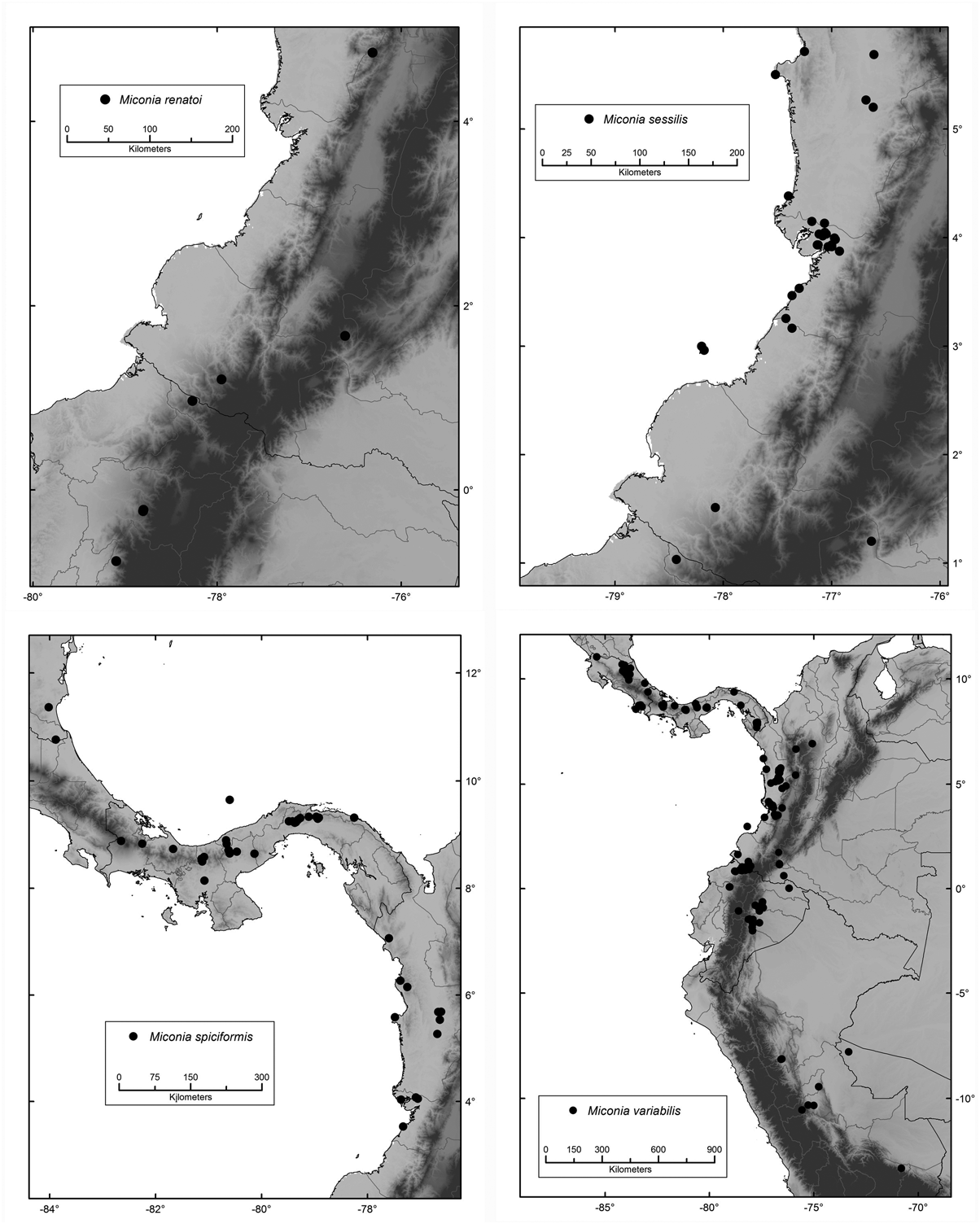
Habitat, distribution and ecology:— Locally common to infrequent in pristine and disturbed primary and secondary rainforests and low cloud forests; commonly growing on steep slopes, from the Biogeographic Chocó region in Colombia throughout the Caribbean slope of Panama, disjunctly to southern Nicaragua in the Indio-Maíz Reserve ( Fig. 17 View FIGURE 17 ), at 5–1200 m. To be expected in Costa Rica.
Phenology:— Collected in flower and fruit from January through September; only flowering collections have been made in August.
Etymology:— The specific epithet refers to the spiciform subverticillate inflorescence.
Discussion:— The distinctive features of this species are the whitish tomentose indumentum and subverticillate spicate inflorescence. In the protologue, Gleason (1941) described the ovary of this species as 3- celled based on Colombian material. All Central American specimens ( Almeda 2009) examined have 5-celled ovaries like those examined from Colombia. No 3–celled ovaries were seen in any of the material assembled for this study, which suggests that Gleason's observation is probably erroneous.
In its spicate bracteate inflorescence Miconia spiciformis is reminiscent of M. rufibarbis , which is a much coarser plant with plinerved leaves, copious indumentum on the inflorescence and internodes, and larger bracts. Phylogenetically these taxa are sister species and belong to a clade containing M. bractiflora , M. formicaria , and M. magnifolia .
Conservation status:— This species would be considered Endangered EN B2ab(iii) based on IUCN criteria. However, this fairly rare species occurs in some protected areas within its range, so a status of Vulnerable VU is warranted. It is protected in Colombia inside El Amargal Biological Station (Chocó). In Nicaragua it is protected in the Indio-Maíz Reserve (Río San Juan and Zelaya). In Panama it is protected in the Chagres National Park ( Panama) and in the PEMASKY Nature Park (San Blas).

| COL |
Universidad Nacional de Colombia |
| MO |
Missouri Botanical Garden |
| US |
University of Stellenbosch |
| NY |
William and Lynda Steere Herbarium of the New York Botanical Garden |
| CAS |
California Academy of Sciences |
| PMA |
Provincial Museum of Alberta |
No known copyright restrictions apply. See Agosti, D., Egloff, W., 2009. Taxonomic information exchange and copyright: the Plazi approach. BMC Research Notes 2009, 2:53 for further explanation.
|
Kingdom |
|
|
Phylum |
|
|
Class |
|
|
Order |
|
|
Family |
|
|
Genus |