
Passiflora coloranigra Kuethe & Meerman, 2022
|
publication ID |
https://doi.org/ 10.11646/phytotaxa.561.2.7 |
|
DOI |
https://doi.org/10.5281/zenodo.7059495 |
|
persistent identifier |
https://treatment.plazi.org/id/67637420-FF9E-D472-FF5A-96A0B7134E0D |
|
treatment provided by |
Plazi |
|
scientific name |
Passiflora coloranigra Kuethe & Meerman |
| status |
sp. nov. |
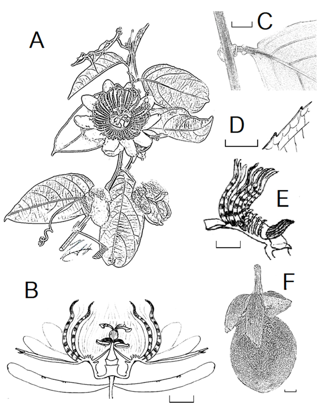
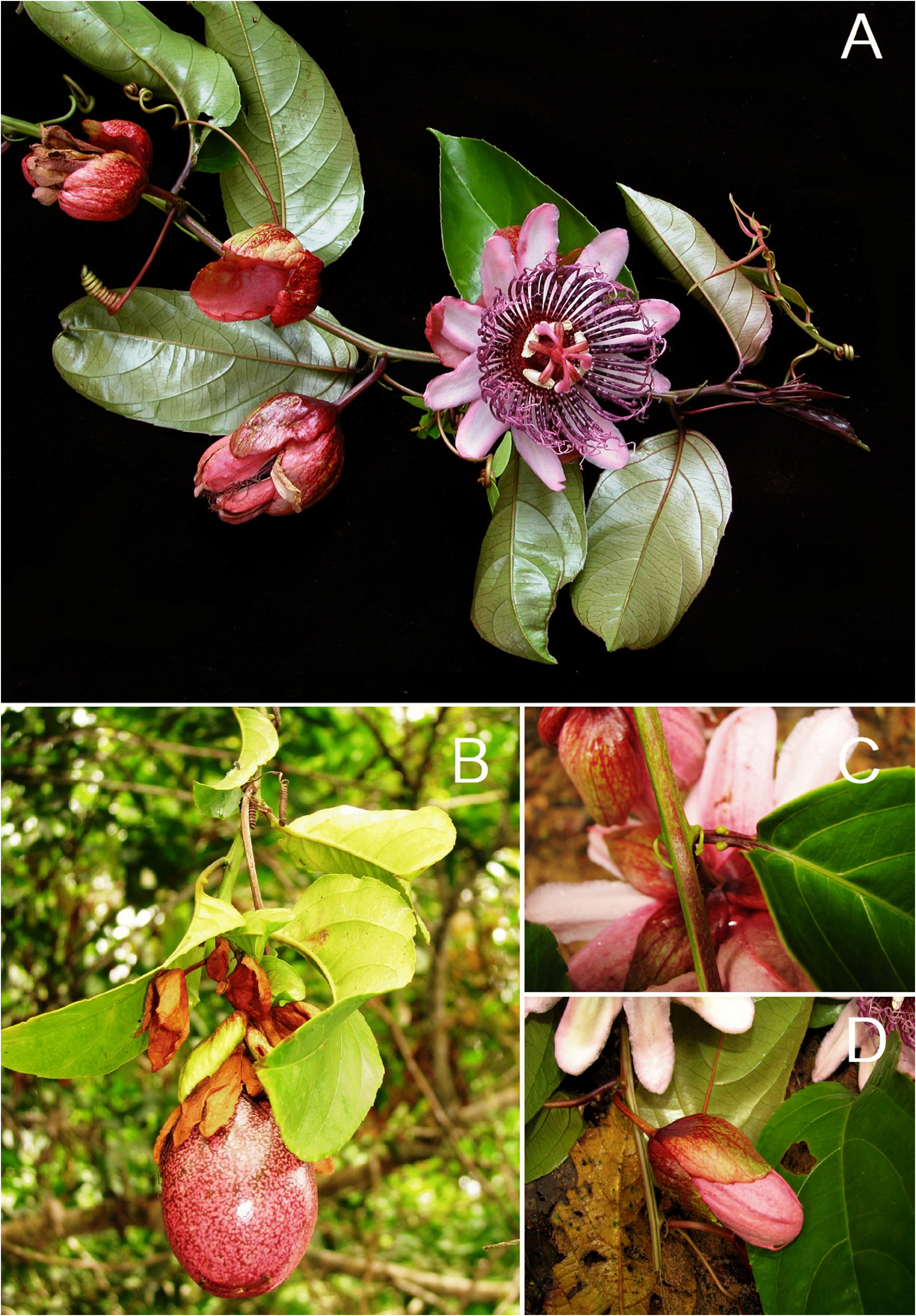
Passiflora coloranigra Kuethe & Meerman View in CoL , sp. nov. ( Figures 1–3 View FIGURE 1 View FIGURE 2 View FIGURE 3 )
Type:— PANAMA. Cólon province: Donoso district, east of Pamilla, Orilla del Río Caimito , 09°00’54”N 080°41’31”W, 10–50 m, 5 March 2008, Blanca Araúz & Jan Meerman 1691 (holotype: F!; GoogleMaps isotypes: MO, STRI!, US!) GoogleMaps .
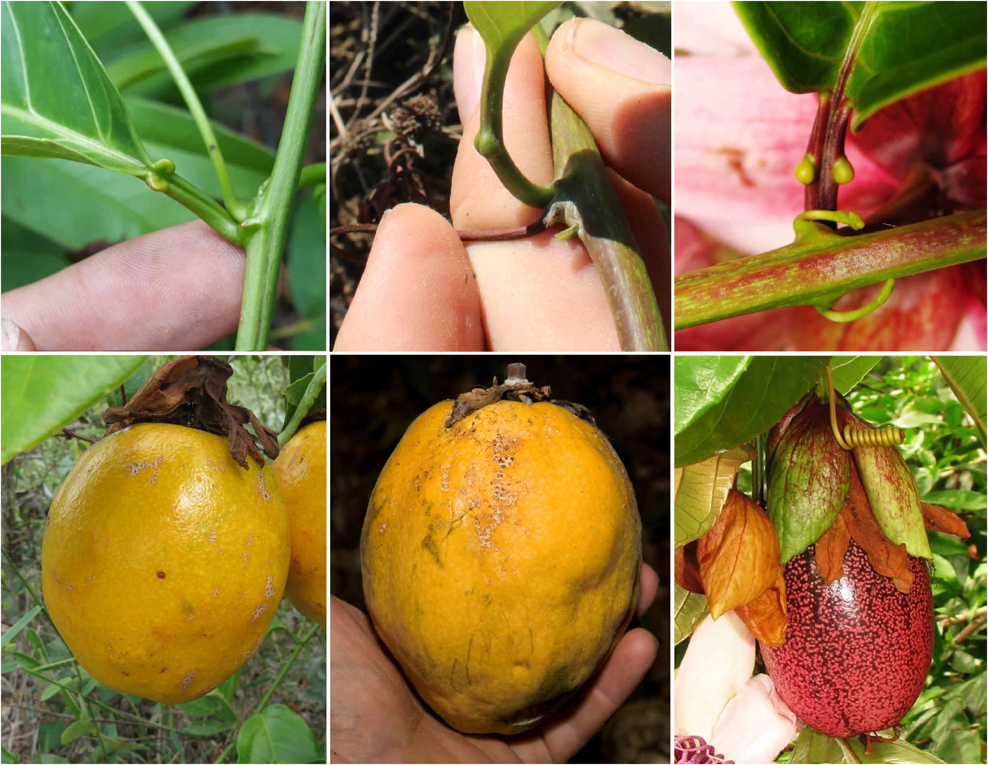
Diagnosis:—This new species belongs to subgenus Passiflora supersect. Laurifoliae, where it appears to be morphologically related to Passiflora nitida . The two species can easily be distinguished by the red-purple colour of the flower and fruit of Passiflora coloranigra , whereas in Passiflora nitida the flower is white with blue, followed by a yellow-orange fruit. The location of the petiolar nectaries in this species are located near the middle of the petiole, while in Passiflora nitida they are located near the apex of the petiole.
Description:—Plant: wooden vine or liana, glabrous throughout, except ovary. Stem: Mainly terete, younger shoots occasionally a little striate, reddish to reddish-purple to green. Stipules: hooked, ca. 15 mm long, lanceolate to tubular, apically glandular occasionally deciduous, green. Tendrils: well-developed, red to purple-colored to green when mature. Petioles: (1.3–)2–4(–5) cm long, with one pair of ovate, sessile, green glands, located just above middle of the petiole. Leaves: ovate-oblong to ovate-elliptic, (10–)13–20(–25) × (5–)7–10(–13) cm, obtuse at base, acute to acuminate at apex, entirely pinnate-veined, thick coriaceous and shiny at the adaxial surface, thick coriaceous and dull beneath. Leaf margin: green, slightly dentate to distally serrate, glandular. Laminar nectaries: absent. Juvenile branches: Membranous, shiny, deeply tinted purple to red (especially abaxially), turning green when older. Inflorescence: solitary on the younger wood. Peduncles: terete, glabrous, (3–) 4–5 cm long. Bracts: involucrate to ovate, free inserted ca. 2 mm below flower, 3–4 × 4–4.5 cm, margin partially with several stout brown glands, color variable; from cherry-red to olive green. Hypanthium: campanulate, cherry-red to pinkish-purple. Sepals: fleshy, ovate to lanceolate, 3.5–4.2 × 2–2.2 cm, obtuse, colours consistent, cherry-red abaxially, deep pink adaxially. Petals: subequal to sepals, narrowovate to acuminate, 3.5–4 × 1.5–2 cm, rich pink from both sides. Corona: filaments in 5–6 series; filaments of outer series: stout at the base, distally wavy, ligulate, 4.5–5.2 cm long, very dark purple near the base, and more pinkish to whitish pink distally, with 4–6 lighter pinkish bands in lower half; filaments of second series quite similar to the outer series, stout at the base and wavy at the apex, ligulate, 4.5–5 cm, cross-banded with dark purple and white; third to fifth series minute, filiform, reddish black, 0.4–0.6 cm, slightly curved inwards for the apical 2 mm; innermost series erect-linear, reddish purple, slightly inclined towards the androgynophore, slightly longer the preceding rows, 0.8–1 cm. Trochlea absent. Androgynophore: red to cherry red, 3–3.5 cm long. Ovary: tomentose, reddish pink, very finely sericeous, ellipsoid to obovoid. Filaments: red to cherry. Anthers: white to yellow. Mature fruits: ovoid, 9–11 × 5–6 cm, bright orange to deep purple red with darker spots when mature, edible, and very sweet.
Etymology:—The specific epithet is derived from the Latin combination “ Colores Nigra ”, meaning “dark colours”. This refers to the unusual dark purple coloration of the juvenile branches, buds, petals, sepals, corona and fruit.
Phenology:—This new species was found in flower between March and July. This corresponds with the beginning of the Panamanian wet season. The fruits have been seen on the plant between June and August. The morphology of the flower suggests pollination by medium to large carpenter bees, although this has not been observed in situ.
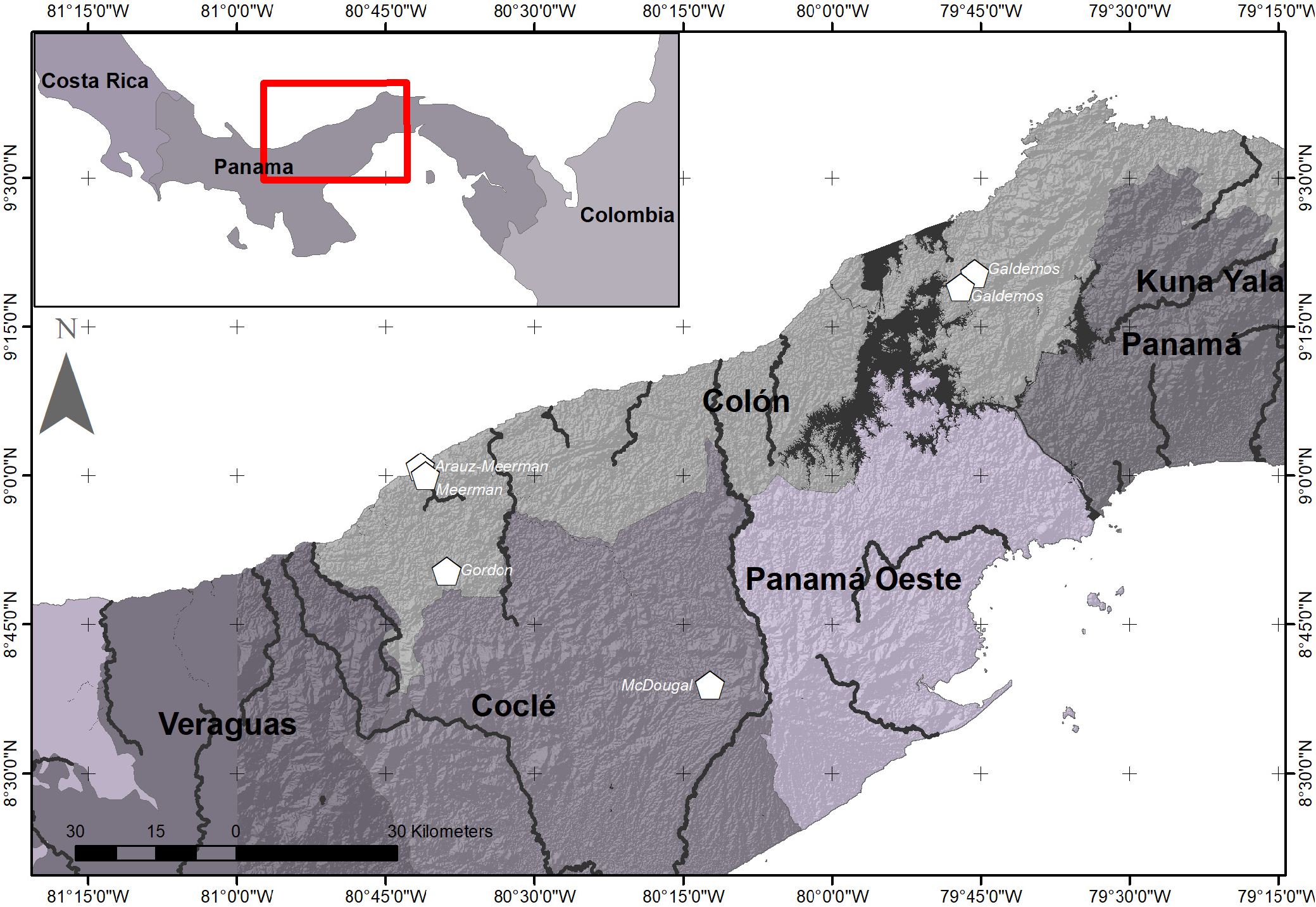
Distribution and ecology:— Passiflora coloranigra has been collected at three locations in the vicinity of the Canal region of Panama ( Fig. 4 View FIGURE 4 ), where it grows in wet broadleaf forest ranging from sea-level up to 250 m elevation. The first collection was found along the Santa Rita Ridge road, which transects a small rainforest strip at the east side of the Parque Nacional Chagres, Cólon, Central Panama. This area is characterized by very wet broadleaf forest with a high rate of rainfall (about 3000 mm annually), occasional nubiculous precipitation, and high humidity year-round.
The second and third collection were at a lower elevation, and both were found closer to the Canal Zone area in the Soberanía National Park. Furthermore, the second author reported a large plant covering a tall tree growing on the NW side of the small island in the Rio Caimito, Donoso district, Cólon Province. The island itself rose barely above river level (<20 m a.s.l.) and is probably subject to frequent flooding which is common in this area receiving about 4,000 mm of rain per year. The lateritic soils of the island are mostly Andesitic/Basaltic sand and gravel, reflecting the general geology of the Donoso district.
Conservation:—During early 2019, the first author visited the first location along the Santa Rita Ridge road, which marks a small piece of remnant cloud forest on the edge of the orographic barrier that divides the drainage zone from the Atlantic (Caribbean) and Pacific rainfall, respectively. Unfortunately, the area was strongly deforested to make space for agriculture, and no new plants of P. coloranigra were found. The second location is within the periphery of a national park, and thus should be better protected against agricultural development. The Rio Caimito location does not enclose a protected area, though reportedly the plants were growing in brook forest that is unsuitable for agricultural development (Meerman, pers. comm.). Unfortunately, the species has not yet been introduced into cultivation and cultivation efforts should be encouraged.
Additional specimens examined (paratypes):— P. coloranigra : PANAMA. Cólon province: Carretera Santa Rita - Sierra Llorona , 160-180 m, 09°19’N 079°47’W, 6 April 2006, C GoogleMaps . Galdames & Carla Chízmar 5548 ( STRI); Santa Rita , on a small road, 5 km North of Santa Rita Arriba, 160–180 m, 9°20’24.0”N 79°45’36.0”W, 6 April 2006, C GoogleMaps . Galdames & Carla Chízmar 5549 ( STRI); Santa Rita Arriba, Dick Howard, Smithsonian Institution [Only known from picture ( RAH _053 rah05271.tif)]; Teck Cominco Petaquilla mining concession, collected near plot C003 , 184 m, 08°50’22”N 080°38’51”W, 18 September 2007, Gordon McPherson 19669 ( MO); GoogleMaps Between Penonomé and Cerro La Vieja , 383 m, 08°38’53”N 080°12’18”W, 19 July 2009, John M GoogleMaps . MacDougal, Jorge Lezcano & T . Skimina 6287 ( MO); Panamá province: El Llano –Cartí road, Interamerican Hwy. to continental divide, ca. 8 km from Interamerican Hwy , 380 m, 09°16’30”N 078°57’30”W, 23 July 2009, John M GoogleMaps . MacDougal, Jorge Lezcano & T . Skimina 6309 ( MO); Canal Zone , summit, May 1931, Q. V . Lindsay 230 ( US); Barro Colorado Island , 10-100 m, 09°09’N 079°51’W, 24 January 1936, J GoogleMaps . Zetec 3620 ( MO) .
Additional specimens examined:— P. ambigua : BELIZE. Toledo District: Machaca, 50 ft., 8 February 1934, W. A . Schipp 1302 ( F) ; Stann Creek District: Stann Creek valley, Mountain Cow Ridge , 12 March 1940, P. H . Gentle 3254 ( F) . COSTA RICA. Alajuela: Upala, Parque Nacional Guanacaste, Cordillera de Guanacaste, Estación San Ramón , Sendero El Argentino Dos Ríos, 550 m, 10°52’48”N 085°24’00”W, 23 March 1994, Dunia García 147 ( CR, MO) GoogleMaps ; San José 11 Km al Noreste del pueblo, Asentamiento campesino Jomusa , Río Palo Quemado , 40 m, 10°58’48”N 085°06’36”W, 14 April 1988, Gerardo Herrera Ch. 1814 ( CR, MO); GoogleMaps Parque Rincón de la Vieja Hacienda Santa María; del mirador siguiendo la Fila al Noreste, camino al Volcán Santa María, 800 m, 10°48’00”N 085°18’36”W, 19 October 1987, Gerardo Herrera Ch. 908 ( CR, MO) GoogleMaps ; Puntarenas: Golfo Dulce, Península de Osa, Bahía Chal , 3 Km antes de Rincón, 20 m, 08°43’12”N 083°26’24”W, 10 January 1994, Nelson Zamora, Mery Ocampo & V GoogleMaps . Alpízar 2188 ( CR, MO) . NICARAGUA. Atlántico Sur: E. G . Sturridge s.n. ( K) .
| F |
Field Museum of Natural History, Botany Department |
| MO |
Missouri Botanical Garden |
| STRI |
Smithsonian Tropical Research Institute |
| C |
University of Copenhagen |
| M |
Botanische Staatssammlung München |
| T |
Tavera, Department of Geology and Geophysics |
| Q |
Universidad Central |
| V |
Royal British Columbia Museum - Herbarium |
| J |
University of the Witwatersrand |
| W |
Naturhistorisches Museum Wien |
| A |
Harvard University - Arnold Arboretum |
| P |
Museum National d' Histoire Naturelle, Paris (MNHN) - Vascular Plants |
| H |
University of Helsinki |
| CR |
Museo Nacional de Costa Rica |
| E |
Royal Botanic Garden Edinburgh |
| G |
Conservatoire et Jardin botaniques de la Ville de Genève |
| K |
Royal Botanic Gardens |
No known copyright restrictions apply. See Agosti, D., Egloff, W., 2009. Taxonomic information exchange and copyright: the Plazi approach. BMC Research Notes 2009, 2:53 for further explanation.
|
Kingdom |
|
|
Phylum |
|
|
Class |
|
|
Order |
|
|
Family |
|
|
Genus |