
Abrahamia thouvenotii (Lecomte) Randrian. & Lowry
|
publication ID |
https://doi.org/ 10.5281/zenodo.7618113 |
|
DOI |
https://doi.org/10.5281/zenodo.7620660 |
|
persistent identifier |
https://treatment.plazi.org/id/038887C6-FF4F-FF5C-FE43-83631B7E0D26 |
|
treatment provided by |
Carolina |
|
scientific name |
Abrahamia thouvenotii (Lecomte) Randrian. & Lowry |
| status |
|
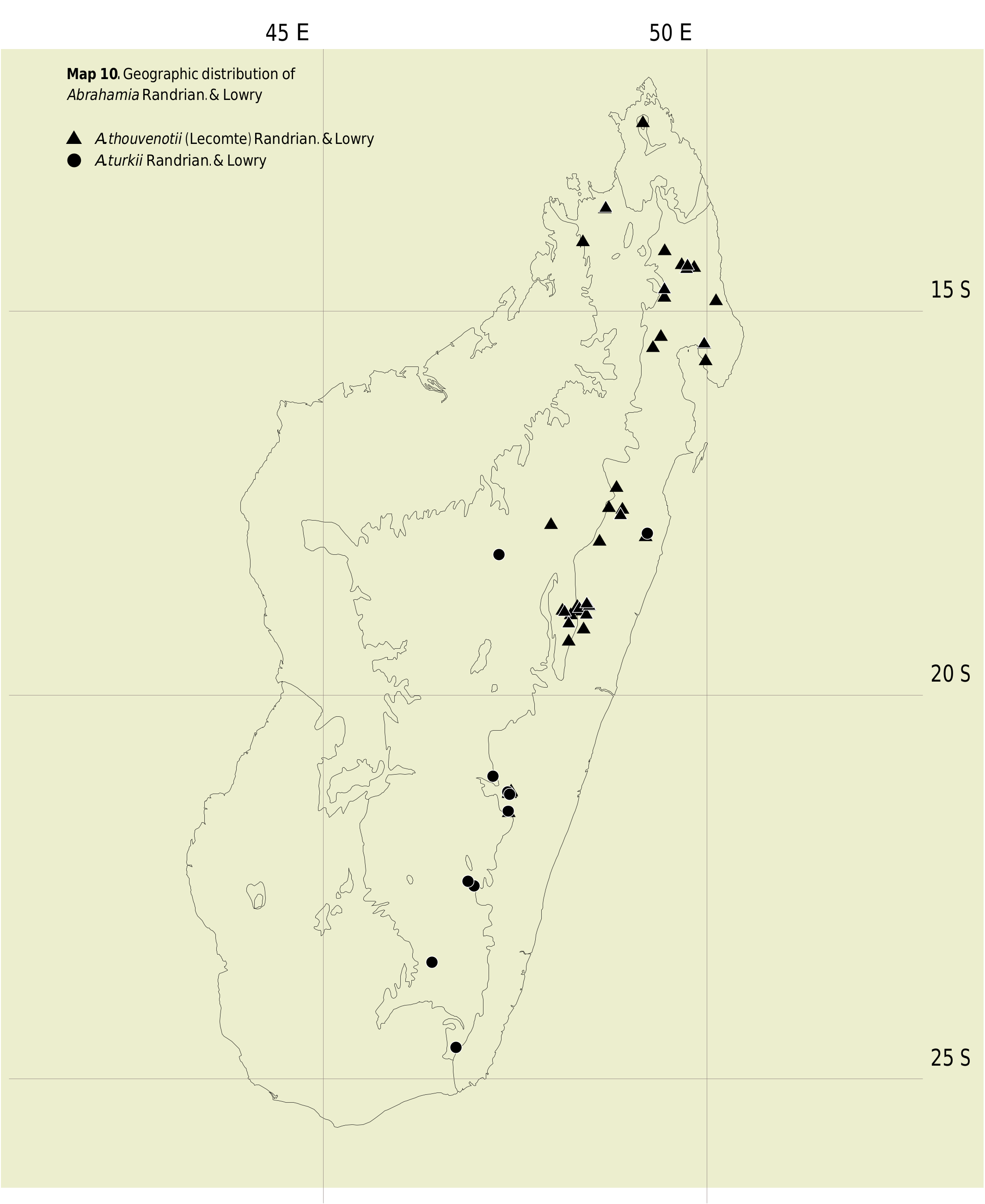
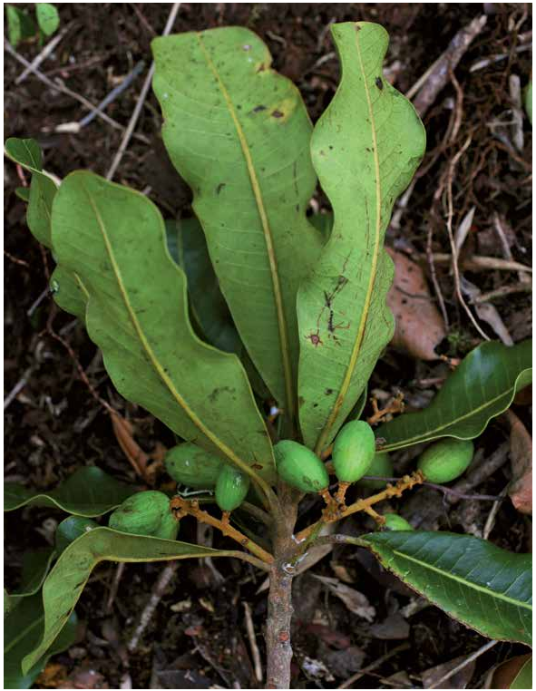
32. Abrahamia thouvenotii (Lecomte) Randrian. & Lowry View in CoL View at ENA , comb. nova ( Fig. 30 View Fig ).
≡ Protorhus thouvenotii Lecomte View in CoL , Madagascar Bois Analamazaotra: 73. 1922.
Lectotypus (designated here): MADAGASCAR. Prov. Toamasina: Rég. Alaotra-Mangoro , Moramanga, Forêt d’Analamazaotra, [18°56’S 48°26’E], 1000 m, s.d., fr., Thouvenot 80 ( P [ P00580346 ]!; GoogleMaps isolecto-: MO- 6684138 !, P [ P00580347 ]!, TAN [ TAN000076 View Materials ]!). GoogleMaps
Description
Trees 5-20 m tall, 5-54 cm DBH, bark with white milky latex; young twigs ferruginous pubescent. Leaves alternate; blades oblanceolate to obovate or elliptic to narrowly elliptic or narrowly oblong, 3-15 3 1.5-5 cm, coriaceous, apex emarginate, retuse, or shortly acuminate, sometimes truncate, margin entire, base acute to cuneate or obtuse, adaxial surface ferruginous pubescent when young, later glabrescent or pubescent only on the midvein, abaxial surface pubescent, venation craspedodromous, midvein prominent abaxially, secondary veins 10-20 pairs, arcuate, 2-10(-15) mm apart, prominent on both surfaces, tertiary veins raised on both surfaces; petiole 5-15 mm long, canaliculate on adaxial surface, pubescent, sometimes glabrescent. Inflorescence axillary or terminal, a panicle, 3-8 cm long, axes terete, tomentose. Male and female flowers 5-merous; pedicel 0-0.3 mm long, pubescent; calyx lobes deltate to ovate, 1.2-1.5 3 1-1.5 mm, imbricate, adaxial surface glabrous, abaxial surface pubescent, persistent on fruit; corolla lobes ovate, 2-3 3 1-1.2 mm, imbricate, adaxial surface pale yellow, glabrous, abaxial surface brown, pubescent; stamens 5. Male flowers with filaments 1 mm long, glabrous, white, anthers 0.6-0.8 mm long, ovoid, yellow, glabrous; disk 1-1.2 mm in diam., pubescent; ovary rudimentary. Female flowers with filaments c. 0.8-1 mm long, glabrous, white, anthers c. 0.5-0.6 mm long, subglobose or ovoid, sterile, yellow, glabrous; disk 1.5-2 mm in diam., pubescent; ovary widely to very widely ovoid, c. 1-1.2 3 1 mm, pubescent, placentation subapical; style very shortly trifid, apical, 0.3-0.4 mm long, covered with indument. Fruits 1.5-2.5 3 0.8-1.5 cm, ellipsoid, very often glabrate or glabrescent, rarely completely glabrous, with longitudinal striations.
Vernacular names
“Ditimena’’, “Menavahatra’’, “Tandraviravy’’ (North East).
Distribution, ecology and phenology
Abrahamia thouvenotii occurs mainly in eastern Madagascar and the Sambirano region ( Map 10 View Map 10 ). It is found principally in mid-elevation rainforests at an elevation between 800 and 900 m, although a few subpopulations have been recorded at much higher elevations. Flowers have generally been collected from August to October, although some individuals may flower as early as July. Fruits have been recorded between November and January.
Conservation status
With an EOO of 116,472 km 2, a minimum AOO of 180 km 2, and 46 recorded localities, with subpopulations in at least 10 protected areas (Anjanaharibe-Sud, Makira, Manon-garivo, Mantadia, Marojejy, Masoala, Montagne d’Ambre, Analamazaotra, Ranomafana, and Zahamena), A. thouvenotii is assigned a preliminary conservation status of “Least Concern’’ [LC] using the IUCN Red List Categories and Criteria ( IUCN, 2012).
Notes
Abrahamia thouvenotii can be distinguished from other members of the genus by the presence of widely spaced secondary leaf venation and indument on the ovary and disk. Three collections from northern and northeastern Madagascar (Miller 3625, Service Forestier 15067 and Ursch 195) differ from typical material by having flowers with a gla-brous disk. Additional collections from this area, especially from female individuals, will be needed, however, to determine whether they may represent a distinct taxon. Until such time, we have chosen to include them in our circumscription of A. thouvenotii .
PERRIER DE LA BâTHIE (1944) cited two collections in the protologue of Protorhus thouvenotii , one in bud (Thouvenot 7) and the other in fruit (Thouvenot 80). We have designated a sheet of Thouvenot 80 as the lectotype because it is represented by two additional specimens, whereas there is only a single sheet of Thouvenot 7.
Protorhus lecomtei (≡ Abrahamia lecomtei ) was based on two collections that belong to different taxa, one of which (Perrier de la Bâthie 5283) we have placed in A. thouvenotii . As indicated above under A. lecomtei , we have designated a specimen of the other syntype gathering, Perrier de la Bâthie 14301, as the lectotype in order to retain a circum-scription that includes the additional material assigned by PERRIER DE LA BâTHIE (1944) to Protorhus lecomtei .
Additional material examined
MADAGASCAR. Prov. Antananarivo: Anjozorobe , 2 km NNE d’Andranomay, 18°28’08’’S 47°57’03’’E, 1340-1400 m, 20.XII.1996, fr., Birkinshaw et al. 373 ( G, K, MO, P, TAN). GoogleMaps Prov. Antsiranana: Ambilobe, forêt de Kalabenono , 13°38’43’’S 48°40’41’’E, 971 m, 27.XI.2006, fr., Callmander et al. 643 ( G, NY, MO, P, TAN); GoogleMaps Marojejy PN, versant S de Beondroka, 14°25’S 49°50’E, 600 m, 14.XI.1989, bud, Deroin & Badré 96 ( MO, P, TAN) GoogleMaps ; Ambanja, Antsatrotro ( Manongarivo ), [14°05’S 48°23’E], 800 m, XI.1954, fr., Service Forestier 11505 ( P [3 sheets], TEF); GoogleMaps Andapa, SW edge of Anjanaharibe-Sud Reserve , 14°48’15’’S 49°26’45’’E, 1000- 1100 m, 6.VIII.1997, bud, McPherson 17266 ( G, K, MO, P, TAN) GoogleMaps ; Marojejy PN, NW Manantenina, Campement n° 3, 14°26.2’S 49°44.5’E, 1200 m, 1.XI.1996, fl., Messmer et al. 305 ( G, MO, P, TAN); GoogleMaps Montagne d’Ambre , 12°32’S 49°10’E, 1050 m, 21.X.1988, fl., Miller 3625 ( MO [2 sheets], P, TAN); GoogleMaps Ambilobe, Antanambao Belinta village, Kalabinono , 13°39’22’’S 48°40’11’’E, 1004 m, 3.XI.2007, fr., Rakotovao 3897 ( G, MO, P, TAN); GoogleMaps Marojejy PN, env. d’Andohan’Antsahamberokely et Marojejybe , 14°25’45’’S 49°40’20’’E, 1672 m, 7.III.1994, fr., Rasoavimbahoaka 176 ( MO, P, TAN) GoogleMaps ; Andapa-Bealanana, Befingotra , 14°12’S 49°27’E, 1100 m, 13-18.IX.1996, fl., Ravelonarivo et al. 1029 ( G, K, MO, P, TAN); GoogleMaps Marojejy PN, between Campsite II and Campsite III, 14°25’09’’- 14°25’24’’S 49°44’46’’- 49°45’29’’E, 1280- 1350 m, 23.XI.2003, fl., Schmidt et al. 4308 ( G, K, MO, P, TAN); GoogleMaps Antalaha, Ambodigavo-Maromandia , [14°51’S 50°07’E], 120 m, 11.IX.1955, bud, Service Forestier 15067 ( P [2 sheets], TEF); GoogleMaps forêt d’Ambre, [12°36’S 49°09’E], 16.VI.1954, ster., Service Forestier 160-R-152 ( P); GoogleMaps Diego Suarez , [12°16’S 49°17’E], 17.X.1927, bud, Ursch 195 ( P). GoogleMaps Prov. Fianarantsoa: Ifanadiana , 7 km W of Ranomafana, 21°16’S 47°25’E, 1000 m, 19.X.1987, ster., Daniels 95 ( MO, P, UMO); GoogleMaps Ranomafana PN, parcelle 3, Talatakely , Piste C, [21°15’S 47°27’E], 1645 m, 3-8.IX.1993, fl., Kotozafy et al. 230 ( G, K, MO, NY, P, TAN, WAG); GoogleMaps Ranomafana PN, Vatoharanana , Parcelle 3, 21°16’S 47°26’E, 900- 1100 m, ster., Kotozafy et al. 544 ( MO, P, TAN); GoogleMaps Ranomafana PN, parcelle 3, 21°16’S 47°26’E, 980 m, 16-19.II.1994, ster., Rakoto et al. 514 ( MO, P, TAN); GoogleMaps Ranomafana PN, Talatakely area , 21°16’S 47°25’E, 800- 900 m, 8.X.1996, ster., A. Randrianasolo 497 ( MO, P, TAN); GoogleMaps Ranomafana NP, parcelle 3, 21°15’30’’S 47°25’E, 900- 1100 m, 23.IX.1994, fl., J. Randrianasolo et al. 154 ( MO, P, TAN); GoogleMaps ibid. loco, J. Randrianasolo et al. 155 ( MO, P, TAN); GoogleMaps ibid. loco, J. Randrianasolo et al. 157 ( MO, P, TAN); GoogleMaps Andrambovato , E de Fianarantsoa, [21°31’S 47°25’E], 878- 1000 m, 24-25.I.1955, ster., Service Forestier 11587 ( P, TEF); GoogleMaps ibid. loco, Service Forestier 13260 ( P); GoogleMaps Ranomafana PN, Talatakely trail system, 21°15’30’’S 47°25’00’’E, 950- 1150 m, 23. IX.1993, fl., Solo & J. Randrianasolo 8 ( MO, P, TAN); GoogleMaps ibid. loco, 16.VIII.1993, fl., Turk et al. 527 ( G, K, MO, NY, P, TAN, WAG); GoogleMaps Ranomafana PN, parcelle I, [21°14’S 14°27’E], 850 m, 29.IX.1994, fl., Turk et al. 637 ( MO, P, TAN). GoogleMaps Prov. Mahajanga: Anjanaharibe-Sud RS, [14°42’S 49°27’E], 1100 m, 14.XII.1994, fr., Ravelonarivo et al. 552 ( MO, P, TAN). GoogleMaps Prov. Toamasina: Vavatenina, Zahamena PN, 17°38’27’’S 48°52’32’’E, 700- 1040 m, 4.X.2001, fl., Andrianjafy et al. 194 ( CNARP, MO, P, TAN); GoogleMaps Masoala PN, Ambohitsitondroina , 15°25’37’’S 45°57’24’’E, 1158 m, 10.X.2003, bud, Antilahimena et al. 2169 ( G, MO, P, TAN); GoogleMaps Commune Vinanibe, Makira forest , 15°27’40’’S 49°17’46’’E, 1153 m, 28.XI.2003, fl., Antilahimena 2421 ( G, K, MO, NY, P, TAN); GoogleMaps Maroantsetra, Ambatofotsy , Andampy forest, 15°19’03’’S 49°24’06’’E, 800 m, 4.IX.2004, fr., Antilahimena 2746 ( G, MO, P, TAN); GoogleMaps Ambatovy, Sahavarina forest , 18°51’37’’S 48°20’25’’E, 1020 m, 24. XI.2005, fr., Antilahimena et al. 4230 ( G, MO, P, TAN); GoogleMaps Ambatovy, Ampangadiantrandraka Forest, 18°51’43’’S 48°17’39’’E, 1049 m, 9.XII.2006, fr., Antilahimena & Edmond 5087 ( G, MO, P, TAN); GoogleMaps forêt d’Analamay, 18°49’37’’S 48°19’11’’E, 1153 m, 6.VI.2007, ster., Bernard et al. 529 ( MO, P, TAN); GoogleMaps Mantadia PN, 700 m N from point PK 13, 18°48’09’’S 48°25’39’’E, 870- 930 m, 23.VI.1996, y. fl., Birkinshaw et al. 313 ( MO, P, TAN); GoogleMaps moyenne vallée du Mangoro , [18°53’S 48°07’E], 10.IX.1942, fl., Decary 18516 ( MO, P); GoogleMaps Analamazaotra, [18°56’S 48°26’E], X.1925, bud, Louvel 44 ( P); GoogleMaps ibid. loco, 1925, bud, Louvel 112 ( P); GoogleMaps Mantadia PN, 10.I.2003, ster., Pell et al. 633 ( MO, NY, P, TAN); GoogleMaps forêt d’Analamazaotra, [18°56’S 48°26’E], 800 m, s.d., fr., Perrier de la Bâthie 5283 ( P [4 sheets]); GoogleMaps Ambatondrazaka , Commune Didy , Fokontany Antsevabe, 17°59’S 48°36’E, 1165 m, 28.IX.2005, fl., Rakotonasolo 1066 ( G, K, MO, P, TAN); GoogleMaps Amparafaravola, E d’Ambodisaina , 17°16’49’’S 48°49’18’’E, 850 m, 11.XII.2001, fr., Rakotondrafara et al. 102 ( CNARP, MO, P, TAN); GoogleMaps 1.5 km E du campement du PK 14, piste de Mantadia PN, 18°49’S 48°26’E, 940- 1012 m, 21.IX.1996, fl., Ralimanana et al. 10 ( G, MO, P, TAN); GoogleMaps Lakato , village Agnalatsara, 19°07’29’’S 48°23’32’’E, 815 m, 1.VI.2007, ster., Ranaivojaona et al. 1724 ( MO, P, TAN); GoogleMaps Analamazaotra RS, [18°56’S 48°26’E], 950 m, 15.VII.1996, ster., A. Randrianasolo 413 ( MO, P, TAN); GoogleMaps Analamazaotra RS, along the Indri trail, about 300 m from observation point, 18°56’12’’S 48°25’10’’E, 1000 m, 10.I.2003, ster., A. Randrianasolo 779 ( MO, TEF); GoogleMaps Analamazaotra forestry station, 18°56’S 48°26’E, 950 m, 19.X.1996, fl., A. Randrianasolo 506 ( MO, P, TAN); GoogleMaps ibid. loco, 18.VII.1996, ster., A GoogleMaps . Randrianasolo 433 ( MO, P, TAN); GoogleMaps ibid. loco, 16.VII.1996, ster., A. Randrianasolo 414 ( MO, P, TAN); GoogleMaps Zahamena PN, forêt communautaire d’Antenina, 17°32’32’’S 48°43’20’’E, 1250 m, 6.XII.2002, fr., Randrianjanaka et al. 762 ( CNARP, G, MO, NY, P, TAN, TEF); GoogleMaps Ambodimangavolo, Ambatoharanana , Moango , 17°33’57’’S 48°53’58’’E, 740- 1200 m, 25.X.2005, fl., Ratovoson et al. 336 ( CNARP, G, MO, P, TAN, TEF); GoogleMaps Ambohibary, Ambatovy , 18°52’28’’S 48°19’19’’E, 1036 m, 12.XII.2011, fr., Ravelonarivo et al. 3972 ( G, K, MO, NY, P, TAN); GoogleMaps entre Analamay et Ambatovy, 18°49’52’’S 48°18’45’’E, 1192 m, 22.XI.2005, fl., Razafindraibe et al. 104 ( MO, P, TAN); GoogleMaps Ambatovy , forêt de cuirasse de Vatovy, 18°51’21’’S 48°18’29’’E, 1104 m, 1.XII.2005, fr., Razanatsoa et al. 194 ( MO, NY, P, TAN); GoogleMaps Masoala Peninsula, SE of Ambanizana, 15°38’S 49°59’E, 150- 170 m, 1.XI.1992, bud, Schatz et al. 3401 ( G, MO, P, TAN); GoogleMaps Sahamaloto, Périnet , [18°56’S 48°26’E], 1000 m, 11.X.1952, fl., Service Forestier 6052 ( P [2 sheets], TEF); GoogleMaps massif de l’Ambohitsitondroina de Mahalevona , NW de la presqu’île Masoala, [15°25’S 49°58’E], 900 m, 5. XII.1953, bud, Service Forestier 8714 ( G, MO, P, TEF); GoogleMaps Sahamaloto, Périnet , [19°03’S 48°12’E], 1054 m, 20.IV.1954, y. fr., Service Forestier 10359 ( P, TEF); GoogleMaps Amparafaravola, forêt d’Andranobe, W de Manohilahy , [17°46’S 47°58’E], 1000- 1200 m, 31.VIII.1958, fl., Service Forestier 18772 ( MO, P [2 sheets], TEF); GoogleMaps vestiges de forêts près du village d’Ankarahara (PK 100-102 Antananarivo-Moramanga), Mangoro , [18°54’S 48°09’E], 800 m, 8.VIII.1961, bud, Service Forestier 20337 ( MO, P [3 sheets], TEF); GoogleMaps Analamazaotra, [18°56’S 48°26’E], 1000 m, 21.V.1962, ster., Service Forestier 21142 ( MO, P); GoogleMaps ibid. loco, 25.V.1962, ster., Service Forestier 21143 ( MO, P); GoogleMaps Andasitsimanga, Périnet , [18°53’30’’S 48°22’30’’E], 800- 1000 m, 2.VIII.1962, bud, Service Forestier 21224 ( MO, P); GoogleMaps Perinet , [18°56’S 48°26’E], 1000 m, II.1966, ster., Service Forestier 25720 ( P); GoogleMaps ibid. loco, Service Forestier 25721 ( P); ibid. loco, Service Forestier 25722 ( P); ibid. loco, 29.VI.1966, ster., Service Forestier 25960 ( P); ibid. loco, N. de la pisciculture, III.1966, ster., Service Forestier 25778 ( P); GoogleMaps Ankazomanitra, PK 45 route Moramanga-Anosibe , [18°56’20’’S 48°13’40’’E], 900 m, 9.XI.1968, y. fr., Service Forestier 26830 ( P, TEF); GoogleMaps forêt W d’Antanandava (PK 45 de la route Moramanga-Anosibe ), [19°17’S 48°12’E], 900 m, XI.1968, fr., Service Forestier 28443 ( P); GoogleMaps Sahamaloto, Périnet , [19°03’S 48°12’E], 1054 m, 20.VII.1952, bud, Service Forestier 45B-R-172 ( P, TEF); GoogleMaps ibid. loco, 27.IX.1952, bud, Service Forestier 165B-R-172 ( P, TEF); Ampatsakambe, 28.V.1950, ster., Service Forestier 189B-R-56 ( P).
| TEF |
TEF |
| UMO |
United Kingdom, Oxford, University Museum of Natural History |
| WAG |
WAG |
| CNARP |
CNARP |
| P |
Museum National d' Histoire Naturelle, Paris (MNHN) - Vascular Plants |
| TAN |
Parc de Tsimbazaza |
| G |
Conservatoire et Jardin botaniques de la Ville de Genève |
| K |
Royal Botanic Gardens |
| MO |
Missouri Botanical Garden |
| NY |
William and Lynda Steere Herbarium of the New York Botanical Garden |
| TEF |
Centre National de la Recherche Appliquée au Developement Rural |
| UMO |
University of Maine |
| WAG |
Wageningen University |
No known copyright restrictions apply. See Agosti, D., Egloff, W., 2009. Taxonomic information exchange and copyright: the Plazi approach. BMC Research Notes 2009, 2:53 for further explanation.
|
Kingdom |
|
|
Phylum |
|
|
Class |
|
|
Order |
|
|
Family |
|
|
Genus |
Abrahamia thouvenotii (Lecomte) Randrian. & Lowry
| Randrianasolo, Armand, Lowry II, Porter P. & Schatz, George E. 2017 |
Protorhus thouvenotii
| Lecomte 1922: 73 |